Mori Atlas logo
Nature reserveKlingnauer Stausee

A vital wetland corridor and reservoir landscape within the northern Swiss Jura foothills

Klingnauer Stausee Nature Reserve: Mapping the Aare River Floodplain in Aargau, Switzerland

The Klingnauer Stausee serves as a significant nature reserve and artificial reservoir along the Aare River in the canton of Aargau. This water-dominated landscape preserves a complex mosaic of reedy margins, alluvial forest remnants, and restored backwaters that support dense populations of waterbirds and migratory species. Through this atlas entry, observe how historic hydroelectric infrastructure evolved into a nationally protected habitat within the broader Aare valley geography.

reservoirhydroelectric lakeriver floodplainwetlandalluvial forestbirdwatching

Klingnauer Stausee

Nature reserve

Park overview

Structured park overview, official facts, and landscape profile for Klingnauer Stausee

Klingnauer Stausee park facts, protected area profile, and essential visitor context

Review the core facts for Klingnauer Stausee, including designation, size, terrain, visitor scale, habitats, and operating context in one park-focused overview.

About Klingnauer Stausee

The Klingnauer Stausee occupies a distinctive place in the Swiss protected-area landscape as a working hydroelectric reservoir that has matured into a habitat of national importance. Although the lake itself is entirely anthropogenic, its surroundings retain substantial natural character, including surviving floodplain forest fragments and old meander relics, giving the site a layered identity shaped by river regulation, flood control, and ecological recovery.

The reservoir sits in the lower Aare valley, north of the area traditionally known as the Wasserschloss der Schweiz, where the Aare, Reuss, and Limmat systems converge before meeting the Rhine. The nearest sizeable communities around the lake are Klingnau on the right bank and Böttstein and Leuggern on the left, with Döttingen, Kleindöttingen, and Gippingen also bordering the water. This proximity to inhabited areas means that the lake functions both as a piece of regional infrastructure and as a readily accessible green space for recreation and nature observation.

What sets the Klingnauer Stausee apart is the unusual richness of its birdlife, which has developed over decades as successive bird communities colonized the newly available open water and shoreline habitats. It is supported by deliberate protection, including the lake's status within the national inventory of landscapes of national importance and the adjacent floodplain designations. The result is a compact but ecologically dense site in the Swiss lowlands that demonstrates how heavily regulated rivers can still host vibrant wildlife communities.

For visitors, the area is reached easily from towns along the Aare and is well integrated into Switzerland's network of walking and cycling routes, with an observation tower near Kleindöttingen providing elevated views over the water. Whether approached as a nature destination, a piece of industrial heritage, or a stop along a regional tour, the Klingnauer Stausee offers a coherent story of how a 20th-century engineering project became a long-term ecological asset.

Quick facts and research context for Klingnauer Stausee

Klingnauer Stausee is a regulated reservoir on the lower Aare in the canton of Aargau, just upstream of where the river meets the Rhine. The lake formed behind a weir integrated with the Klingnau hydroelectric power station, built between 1931 and 1935, and stretches roughly three kilometers in length within historic flood protection embankments established after centuries of damaging floods.

The surrounding Aare landscape is included in the federal Inventory of Landscapes and Natural Monuments of National Importance, and parts of it are designated as floodplain areas of national significance. The lake's tributaries include the Surb and the Leuggernbach, and the broader site combines the modern reservoir with old river arms, alluvial forest remnants like the Gippinger Grien, and reclaimed gravel areas that support diverse waterbird and mammal populations.

Protection and recognition

Documented terrestrial protection scope and Ramsar site listings for Klingnauer Stausee

Klingnauer Stausee Protection Status and International Recognition Records

Terrestrial protection records and Ramsar site designations establish the official international recognition status for Klingnauer Stausee. Documented conservation frameworks and administrative sources provide structured context for this protected natural area.

International recognition

Protection details

Protection scope
Terrestrial
Transboundary protection
No
Park context

Deeper park guide and search-rich context for Klingnauer Stausee

Klingnauer Stausee history, landscape, wildlife, and travel context

Explore Klingnauer Stausee through its history, landscape character, ecosystems, wildlife, conservation priorities, cultural context, and seasonal travel timing in a structured park guide built for atlas discovery and search intent.

Why Klingnauer Stausee stands out

The Klingnauer Stausee is best known as one of Switzerland's most rewarding inland birdwatching destinations and as a showcase example of how a man-made reservoir can evolve into a nationally protected floodplain habitat. The combination of open water, sheltered bays, reedy margins, and adjacent alluvial forest remnants attracts large numbers of waterbirds, including herons, ducks, grebes, and seasonal migrants, while rare visitors draw birders from across the country. Equally important is its setting within the broader Aarelandschaft bei Klingnau, a landscape unit of national importance that preserves traces of the historic dynamic Aare floodplain. This pairing of engineered infrastructure and ecological recovery has defined the site's reputation, making it a textbook case of integrated hydropower and conservation in the northern Swiss lowlands.
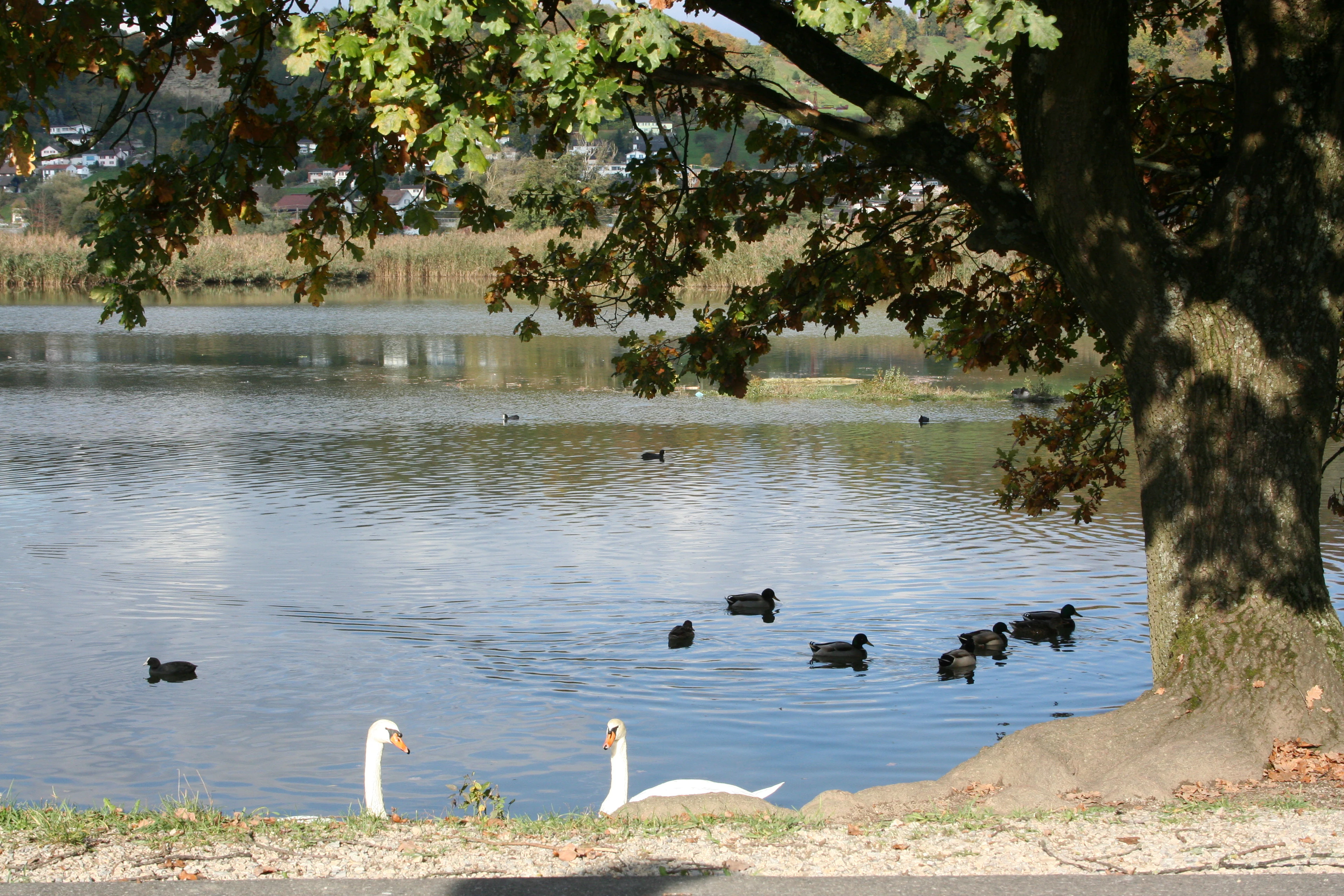
A group of swans and ducks swim in the foreground of a reservoir with an oak tree on the right bank and distant buildings visible across the water.
Swans and ducks on the waters of Klingnauer Stausee during autumn.

Klingnauer Stausee history and protected-area timeline

The history of the Klingnauer Stausee stretches back well beyond the lake itself, into centuries of struggle with flooding along the lower Aare. Communities in the valley endured repeated devastating inundations, and at the close of the 19th century, embankments were built on both sides of the river, reaching from Böttstein almost to Koblenz. These flood protection works straightened the river's course, cut off a meander near Gippingen, and gave rise to a still backwater fed only by groundwater, while another relic arm persists below Klingnau. Around the same era, a large floodplain landscape flourished along the Aare.

Hydroelectric development arrived early. Around 1900 a power plant was built at Beznau near Böttstein, and material excavated for its headrace canal was partly used to fill portions of the old riverbed, which were then planted with forest. About half of that former channel, roughly twenty-three hectares, survived as Auenwald, alluvial floodplain forest, and remains protected today as part of the Gippinger Grien nature reserve. During the First World War, investors began planning a new electricity works north of Klingnau, even starting an access road and a bridge, but abandoned the scheme over concerns about insufficient demand for the power it would have generated. The unfinished bridge stood as a ruin until it was dismantled for safety reasons in 2005.

The reservoir itself came into being between 1931 and 1935 with the construction of the Klingnau hydroelectric power station near the railway bridge between Koblenz and Felsenau, about a kilometer above the Aare's mouth. A weir set between the embankments raised the river level, producing a roughly three-kilometer-long lake up to five hundred meters wide. The power station is integrated into the weir on the right bank, while the Surb joins the Aare at the head of the lake and smaller streams such as the Leuggernbach are diverted around the dam structures to enter downstream of the works.

Within a few years of the lake's filling, several migratory bird species had adopted the new waterbody as a wintering or breeding area, and resident species also expanded into it. More recently, beavers have returned to the lakeshore surroundings, marking the site's further evolution as a wildlife refuge.

Klingnauer Stausee landscape and geographic character

The Klingnauer Stausee is set in a broad, low-elevation stretch of the northern Swiss Jura, where the Aare has been channeled between high flood embankments for over a century. The lake itself is a long, narrow sheet of still water, running approximately three kilometers along the river's course and reaching up to about five hundred meters in width within the historic dike lines. Its surface lies near 318 meters above sea level, reflecting the gentle topography of the Aargau lowlands rather than any mountainous setting.

Surrounding the reservoir, the terrain combines engineered elements with naturally expressive floodplain features. The flood protection embankments form the immediate visual frame, while beyond them the valley floor holds relics of the former braided river system. The old meander near Gippingen now supports quiet backwaters and groundwater-fed ponds, and below Klingnau another disused channel survives as a sheltered wetland corridor. These features contrast with the open expanses of the main lake, producing a varied mosaic of water, marsh, and riparian woodland.

From a scenic standpoint, the lake is most appreciated from its eastern end near Kleindöttingen, where viewpoints and the Klingnauer Beobachtungsturm observation tower offer broad views over the water, reed belts, and the wooded opposite shore near Klingnau. The wider landscape integrates easily into regional walking and cycling routes, with the surrounding Jura ridgelines providing a quiet backdrop to the otherwise flat, water-dominated scene.

Klingnauer Stausee ecosystems, habitats, and plant life

The ecological identity of the Klingnauer Stausee rests on the interplay between an open, regulated lake and a set of surviving and recovering floodplain habitats around it. The lake's shallow margins and relatively quiet waters support diverse aquatic vegetation, while reedbeds and muddy shorelines provide important feeding and resting habitat for waterbirds. The artificial origin of the lake has not prevented it from developing into a functioning wetland ecosystem.

A key ecological partner to the reservoir is the adjacent Gippinger Grien, where around twenty-three hectares of Auenwald, softwood floodplain forest, has been preserved along the relic Aare meander. Together, the lake, the backwaters, and the surrounding woodland form a coherent landscape unit of national importance and are partly protected as Auengebiete von nationaler Bedeutung, floodplain areas of national significance. This designation reflects not just rarity but also the ecological function of these habitats as transition zones between aquatic and terrestrial environments.

Surrounding land use is a mix of forest, agricultural fields, and small settlements, giving the site ecological edges that further enhance its habitat diversity. The combination of standing water, slow-flowing back channels, alluvial forest, and seasonally inundated areas allows a wide range of species to coexist within a relatively compact area, including amphibians, fish, and mammals such as the recently returned beaver.

Klingnauer Stausee wildlife and species highlights

The Klingnauer Stausee is, above all, a birding site. The combination of open water, sheltered bays, reed margins, and adjacent woodland attracts a rich community of waterbirds throughout the year, including various species of ducks, grebes, and herons. Migratory species recognized the lake's value within just a few years of its creation, and the site has continued to develop as a wintering and staging area alongside its role for breeding birds.

Beyond the immediate lakeshore, the Gippinger Grien and other relic floodplain fragments host woodland and scrub species that benefit from the alluvial forest structure. The broader mosaic of habitats supports a varied mammal community as well, with the beaver noted in recent decades as a returning presence around the lake and its connected channels.

The site's relatively compact size and concentration of habitat types make it unusually productive for wildlife observation. The presence of the Klingnauer Beobachtungsturm observation tower near Kleindöttingen underscores this role, providing an accessible vantage point for visitors interested in the lake's diverse fauna.

Klingnauer Stausee conservation status and protection priorities

The Klingnauer Stausee and its surrounding Aare landscape are protected on multiple levels within Switzerland's conservation framework. The entire landscape unit is recorded in the Bundesinventar der Landschaft und Naturdenkmäler von nationaler Bedeutung, the federal Inventory of Landscapes and Natural Heritage Sites of National Importance, recognizing its combined scenic, ecological, and cultural value. In addition, specific areas around the lake, including the Auenwald remnants at Gippinger Grien, are designated as Auengebiete von nationaler Bedeutung, floodplain areas of national significance.

These designations reflect the importance of conserving functioning floodplain and wetland ecosystems in a country where most major rivers have been heavily modified. The lake illustrates how artificial waterbodies, when paired with relic natural features and managed for ecological values, can support nationally significant biodiversity. Conservation of the site also depends on managing conflicts between hydropower operation, recreation, and water quality, a tension made visible by recent disputes over PCB-contaminated sediment that had been proposed for transfer downstream toward the Rhine.

Management of the reserve involves both formal protection and practical measures such as regulated access, public observation infrastructure, and coordination with fisheries and conservation associations. The Klingnauer Stausee therefore stands as a working example of how industrial infrastructure and nature protection can coexist within a Swiss lowland landscape.

Klingnauer Stausee cultural meaning and human context

The Klingnauer Stausee sits within a region shaped by centuries of interaction with the Aare. Communities along the river developed in close relation to its flood dynamics, and the historic struggles with inundation left a lasting imprint on local identity, settlement patterns, and agricultural land use. The decision to construct embankments in the late 19th century, and later to dam the river for hydroelectric power, marked a turning point in which the valley's communities increasingly took control of the river rather than simply adapting to it.

The hydropower era brought industrial infrastructure and electricity-led economic development to the area, with the Klingnau power station and the older Beznau plant becoming part of the regional identity. Around the same time, conservation-minded protection of relic floodplain features such as the Gippinger Grien reflected an emerging awareness of the value of these habitats in an otherwise heavily modified valley.

For visitors and residents, the lake now serves as a familiar everyday landmark and a focal point for outdoor recreation, angling, and birdwatching, while retaining the deeper cultural resonance of a valley whose communities have long learned to live with, and ultimately reshape, a powerful river.

Top sights and standout views in Klingnauer Stausee

The Klingnauer Stausee's most distinctive highlights are the depth of its birdlife, the integrity of its surrounding floodplain landscape, and the unusual story of an industrial reservoir that has become a national nature reserve. The lake serves as a year-round stage for waterbirds, with seasonal shifts that bring new species and new viewing opportunities across every part of the annual cycle.

Equally striking are the surviving relics of the Aare's original floodplain, including the protected Auenwald at Gippinger Grien and the calmer backwaters near Gippingen. These features, combined with accessible viewpoints such as the Klingnauer Beobachtungsturm observation tower and well-developed walking and cycling routes, make the Klingnauer Stausee a compact yet richly layered destination where hydropower heritage, river history, and modern conservation come together.

Best time to visit Klingnauer Stausee

The Klingnauer Stausee rewards visits across much of the year, with each season emphasizing different aspects of its character. In winter, the lake hosts one of its most significant phases, with large numbers of waterfowl gathering on the open water and along sheltered margins, drawing birdwatchers who come specifically for the wintering populations.

Spring and early summer bring breeding activity and the return of migratory species, with reedbeds and wooded shorelines becoming particularly lively. Late summer and autumn offer quieter conditions and often mild weather suitable for walking and cycling around the lake. Birdwatchers tend to favor early morning hours in any season, when activity around the water is at its peak.

Monthly climate preview

Analyzing monthly weather patterns and long-term temperature averages across the protected landscape

Klingnauer Stausee Climate Normals: Measured Temperature and Precipitation Rhythm

Klingnauer Stausee records measured monthly temperatures ranging from sub-zero winter minimums to warm summer maximums alongside consistent daily precipitation. Reviewing the complete twelve-month climatology profile provides deeper insight into long-term environmental patterns across the protected coordinate point.
Annual mean9 °C
-1 °C18 °C
Jan-1°
Feb
Mar
Apr
May13°
Jun17°
Jul18°
Aug18°
Sep14°
Oct
Nov
Dec
Warmest month
July

18.3 °C

Coolest month
January

-0.6 °C

Wettest month
May

4 mm/day

Driest month
February

2.3 mm/day

Park location guide

Geography guide, regional context, and park location map for Klingnauer Stausee

Klingnauer Stausee park geography, regions, and map view in Switzerland

Understand where Klingnauer Stausee sits in Switzerland through a broader geographic reading of the surrounding landscape, nearby location context, and its mapped position within the national park landscape.

How Klingnauer Stausee fits into Switzerland

Switzerland is a landlocked federal republic in Central Europe comprising 26 cantons, with Bern as the federal city and Zurich as the largest city. The country features the Swiss Alps, Swiss Plateau, and Jura Mountains, with German, French, Italian, and Romansh as official languages. It is noted for its political neutrality, direct democracy traditions, and strong economy.

Wider geography shaping Klingnauer Stausee in Switzerland

Switzerland is located in Central Europe at the intersection of Western and Southern Europe. It is bordered by Germany to the north, France to the west, Austria and Liechtenstein to the east, and Italy to the south. The country is geographically divided among the Swiss Alps (covering most of the territory), the Swiss Plateau (where most of the population resides), and the Jura Mountains. Switzerland is landlocked.

Map view of Klingnauer Stausee

Use this park location map to pinpoint Klingnauer Stausee in Switzerland, understand its exact geographic position, and read its mapped placement within the surrounding landscape more clearly.

Pigeon | © OpenStreetMap contributors

Location context for Klingnauer Stausee

Aargau
Recorded earthquake history

View the Historical Earthquake Catalogue for Klingnauer Stausee

Access the complete collection of recorded seismic activity near Klingnauer Stausee through the MoriAtlas historical database. This reference provides documented event dates, magnitudes, and precise epicentre distances, supporting informed geographic discovery within the Aargau landscape.

Klingnauer Stausee Earthquake History

Catalogued events

61 events

Strongest magnitude

Magnitude 4.6

Most recent event

Jun 27, 2024

This history includes earthquakes recorded inside the park or within 50 km of its borders

Protected area imagery highlighting floodplain habitats and reservoir views

Visual Exploration of Klingnauer Stausee Landscapes and Scenery

Photographic records document the open waters, reedy margins, and alluvial forest remnants that define the Klingnauer Stausee environment. Visual documentation reveals the interplay between engineered river embankments and restored wetland habitats across the protected reserve.

A group of swans and ducks swim in the foreground of a reservoir with an oak tree on the right bank and distant buildings visible across the water.

Park atlas

Compare surrounding river floodplains, protected alluvial forests, and regional nature reserves

Exploring Parks Near Klingnauer Stausee and Connected Swiss Wetlands

Visitors exploring Klingnauer Stausee can browse nearby protected areas, wetland complexes, and river valley reserves across the northern Swiss lowlands. Comparing adjacent natural habitats provides broader geographic context into regional conservation efforts and connected ecological corridors.
Watercolor painting of a river landscape with lush green riverbanks, patches of grass in the foreground, and gentle rolling hills in the background.
Protected landscapeAargau
Mapped location lies within the park boundary#1 closest

Northwest

Aarelandschaft bei Klingnau: A Protected Riverine Landscape in Northern Switzerland

Wetland geography, alluvial forests, and floodplain corridors

The Aarelandschaft bei Klingnau preserves a unique riverine mosaic where the Aare River meets the Rhine in northern Aargau. This protected landscape encompasses the Klingnauer Stausee reservoir, rich alluvial forests, and remnant oxbows. It serves as a vital migratory node for avian populations and provides a structured look at the interplay between human-engineered power infrastructure and protected natural river channels.

Area
3.6 km²
Established
1996
IUCN
V
Relief
Lowland
Nature reserveBaden-Württemberg
13 km away#2 closest

Northeast

Blumberger Pforte und Mittlere Wutach: Protected Landscape and Gorge Geography

Nature reserve terrain and ecological atlas in Baden-Württemberg

This protected area captures the dramatic transition where the Wutach river cuts through limestone strata. Discover a rugged landscape mosaic featuring canyon forests, juniper heaths, and karst cave systems across the Swabian Alb and Black Forest fringe. The site offers significant value for understanding regional ecological gradients and limestone-dependent plant communities within the broader southern German geography.

Area
63.25 km²
Established
2019
A watercolor painting showing a panoramic view of green rolling hills and wooded ridges under a soft light.
Regional parkAargau
About 17 km away#3 closest

Southwest

Jurapark Aargau: Geographic Overview of a Swiss Regional Nature Park and Jura Landscapes

Protected Jura mountain terrain and regional landscape mapping

Located in northern Switzerland, Jurapark Aargau encompasses a vast, connected perimeter defined by the interaction of tabular limestone plateaus and dramatic folded mountain ridges. This regional nature park serves as an essential refugium for native flora, preserving ancient geological history through fossil-rich sediments, steep escarpments, and traditional rural land use that persists between the Aargau, Zurich, and Basel regions.

Area
299 km²
Established
2012
Relief
Mountain
Climate
Temperate
A watercolor painting showing a soft, impressionistic landscape with rolling green hills, forest patches, and pale distant mountains under a light sky.
Protected landscapeBaden-Württemberg
About 18 km away#4 closest

West

Obersäckingen Protected Landscape: Regional Geography and Map Context in Baden-Württemberg

A preserved mosaic of southern Black Forest meadows and mixed woodland habitats

Located in the Waldshut district, the Obersäckingen protected landscape showcases a balanced environmental mosaic of oat-grass meadows, hedgerows, and field copses. This area serves as a key piece of the regional conservation network, closely overlapping with the Murg zum Hochrhein Natura 2000 site to maintain the visual and ecological character of the southern Black Forest countryside.

Area
0.415 km²
Established
2004
IUCN
V
Watercolor painting of a pastoral landscape featuring soft, rolling green hills and a small group of evergreen trees, with light pastel mountains in the background.
Protected landscapeBaden-Württemberg
About 21 km away#5 closest

North

St. Blasien Protected Landscape: Geographic Profile and Glacial Mapping

Southern Black Forest protected area in Baden-Württemberg.

The St. Blasien Protected Landscape represents a significant conservation zone in the southern Black Forest. Defined by its strong glacial influence, the area showcases a complex terrain of trough valleys, moraine ridges, and rocky crests alongside centuries-old alpine pastures. Its role in the regional conservation network makes it a key site for understanding the intersection of Pleistocene geography and traditional land management in Germany.

Area
35.754 km²
Established
2002
IUCN
V
Protected landscapeBaden-Württemberg
About 25 km away#6 closest

West

Südwestlicher Dinkelberg Protected Landscape and Dinkelberg Plateau Geography

Karst terrain and forest habitats in Baden-Württemberg

Located in the Lörrach district, Südwestlicher Dinkelberg protects a diverse mix of ravine forests, dry grasslands, and mires. The area preserves essential ecological corridors within the Lörrach-Basel region, showcasing complex geological features such as stream sinks and dry valleys that define the plateau edge.

Area
13.89 km²
Established
2013
IUCN
V
Relief
Upland
A horizontal watercolor painting depicting a landscape with soft rolling hills, green meadows, and wild grasses under a pale sky.
Nature reserveBaden-Württemberg
About 31 km away#7 closest

West

Dinkelberg und Röttler Wald: Geographic Overview of this Baden-Württemberg Nature Reserve

Protected karst landscapes and mature beech forest habitat

Uncover the ecological and physical geography of Dinkelberg und Röttler Wald, a protected area stretching across diverse limestone plateaus and sandstone slopes in Germany. This site offers a valuable look at managed cultural landscapes that bridge the gap between rural meadows and wild forest reserves, providing critical habitat for European bat populations and rare flora across its varied elevational zones.

Area
46.47 km²
Established
2015
A soft watercolor illustration of rolling hills, forested slopes, and meadow vegetation with a light, airy aesthetic.
Nature reserveBaden-Württemberg
31 km away#8 closest

Northwest

Belchen Nature Reserve: Exploring the Mountain Geography of the High Black Forest

A diverse protected landscape in Baden-Württemberg

Belchen represents an essential protected area in the southern Black Forest, known for its compressed ecological profile ranging from lowland beech forests to exposed subalpine summits. The site maps a complex mosaic of scree slopes, mires, and rocky habitats that sustain specialized bat species and rare montane flora, offering a detailed perspective on central European highland ecosystems.

Area
29.072 km²
Established
2019
Relief
Mountain
Climate
Temperate

Common questions about visiting, size, designation, and location context for Klingnauer Stausee

Klingnauer Stausee FAQs for park facts, access, geography, and protected area context

Find quick answers about Klingnauer Stausee, including protected-area facts, park geography, trail and visitor context, and how the park fits into its surrounding country and regional landscape.
MoriAtlas Explorer

Continue Your Protected Areas Search Across the Global Atlas

Deepen your exploration by continuing the structured search for national parks and protected areas worldwide. Utilize the comprehensive filtering capabilities to compare different conservation landscapes and refine your understanding of global park geography. Discover more about the distribution and characteristics of protected natural areas.

Global natural geography