
Mori Atlas logo
Nature reserveKluckbachtal

A preserved mosaic of traditional orchard meadows, hedgerows, and riparian forest habitats

Kluckbachtal Nature Reserve and Mapped Protected Stream Valley in Nordrhein-Westfalen Germany

(Naturschutzgebiet Kluckbachtal)

Kluckbachtal represents a protected valley segment in the northern Eifel foothills, centered on the natural course of the Kluckbach stream. This nature reserve serves as a critical habitat mosaic, encompassing nutrient-poor grasslands, broom shrub, and traditional orchard meadows that define the local Monschauer Heckenland character. As an FFH-designated area, it provides essential ecological corridors for diverse woodland and aquatic species within the broader landscape of Nordrhein-Westfalen.

nature reservestream valleyEifelMonschauhabitat mosaicorchard meadows
A stylized flat vector illustration of a valley landscape featuring foreground meadows with scattered flowering trees, a dense coniferous forest, and distant rock cliffs under a soft sunset sky.

Kluckbachtal

Nature reserve

Park overview

Structured park overview, official facts, and landscape profile for Kluckbachtal

Kluckbachtal park facts, protected area profile, and essential visitor context

Review the core facts for Kluckbachtal, including designation, size, terrain, visitor scale, habitats, and operating context in one park-focused overview.

About Kluckbachtal

Kluckbachtal is a compact but ecologically rich nature reserve located in the Eifel region of western Germany, within the municipal area of Monschau and the broader Städteregion Aachen. Although small by national-park standards, it captures a remarkable cross-section of the traditional cultural landscape of the Monschauer Heckenland, a patchwork of small pastures, hedgerows, orchards, brooks, and wooded valley slopes that has been shaped by generations of farming.

The reserve follows the course of the Kluckbach between the villages of Rohren and Höfen. Its tributary streams rise in grasslands that are still partly intensively used, with a number of artificial fish ponds along the upper reaches. As the valley deepens, the left-hand slope in particular reveals a structurally varied habitat mosaic, including nutrient-poor (Mager) grassland, wet grassland, broom-dominated shrub, surviving hedgerow remnants, rows of predominantly old oak and alder, and several traditional orchard meadows where old fruit trees continue to shape the landscape.

Near the lower end of the valley, the Kluckbach widens to as much as five meters, flowing over a stony bed before emptying into the Rur. At this confluence, a mixed hornbeam forest (Hainbuchenmischwald) has developed, adding a further woodland layer to the reserve's habitat diversity. The combination of flowing water, valley grassland, old trees, and orchard elements gives Kluckbachtal a character that is neither purely wild nor purely agricultural, but a working cultural landscape that has been formally protected for its ecological value.

Quick facts and research context for Kluckbachtal

Kluckbachtal is a roughly 113-hectare nature reserve (Naturschutzgebiet) in Monschau, Städteregion Aachen, North Rhine-Westphalia, Germany, classified as IUCN Category IV (Habitat/Species Management Area). It lies in the valley between Rohren and Höfen along the Kluckbach stream, with the identification code ACK-052 and WDPA ID 318671. Established in 1997 and reconfirmed in 2004, it is managed under the Monschau landscape plan by the lower landscape authority of the Städteregion Aachen.

Protection and recognition

Examine the verified terrestrial conservation scope and recognition history for Kluckbachtal.

Kluckbachtal Protection Status and Documented Protected Area Records

Kluckbachtal maintains a recorded terrestrial protection status governed by official conservation frameworks and administrative records. Review the structured designation details and international recognition parameters associated with this protected landscape.

Protection details

Protection scope
Terrestrial
Transboundary protection
No
WDPA ID
318671
Park context

Deeper park guide and search-rich context for Kluckbachtal

Kluckbachtal history, landscape, wildlife, and travel context

Explore Kluckbachtal through its history, landscape character, ecosystems, wildlife, conservation priorities, cultural context, and seasonal travel timing in a structured park guide built for atlas discovery and search intent.

Why Kluckbachtal stands out

Kluckbachtal is best known for its protected stream and valley habitat complex in the Monschauer Heckenland, combining near-natural stretches of the Kluckbach with steep slopes of species-rich grassland, wet meadows, broom shrub, hedgerows, traditional orchard meadows, and old oak and alder trees. Its designation under the EU Habitats Directive reflects the conservation importance of its flowing waters with underwater vegetation and moist tall-herb fringes, as well as its role as habitat for Red List species such as kingfisher, black woodpecker, grey-headed woodpecker, yellow wild daffodil, and bullhead.
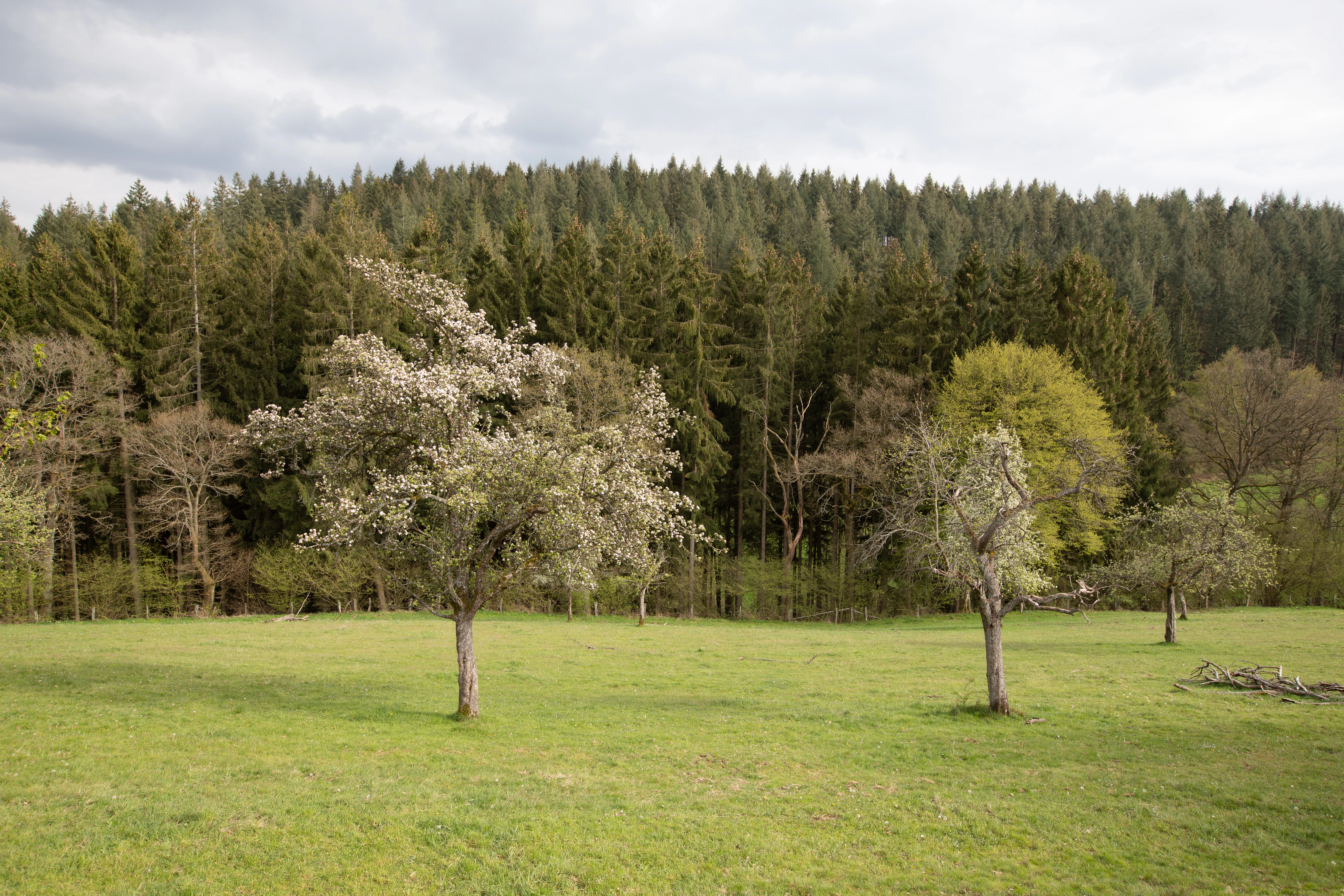
A green, open pasture with scattered flowering fruit trees in the foreground, backed by a dense coniferous forest under a cloudy sky.
Pasture meadow with blooming fruit trees in the Kluckbachtal nature reserve.

Kluckbachtal history and protected-area timeline

Kluckbachtal was formally designated as a nature reserve (Naturschutzgebiet) in 1997, with the existing boundaries and protections revised and reaffirmed in 2004. The reserve was formulated within the framework of the Monschau landscape plan (Landschaftsplan), and administrative responsibility rests with the lower landscape authority (Untere Landschaftsbehörde) of the Städteregion Aachen.

Its conservation designation reflects the broader European push to protect representative stream and valley habitats under the EU Habitats Directive (FFH-Richtlinie). The reserve's listed features include flowing waters with underwater vegetation and moist tall-herb fringes (Hochstaudensäume), explicitly targeted for preservation and development. As a result, Kluckbachtal's history is less about dramatic episodes and more about the gradual institutionalization of protection around a regionally valued valley landscape.

Kluckbachtal landscape and geographic character

The landscape of Kluckbachtal is a narrow, dissected valley typical of the northern Eifel foothills. Steep slopes flank the Kluckbach and its small tributaries, creating a transition from flat, partly intensively used grassland on the upper valley edges to increasingly varied habitats lower down.

The valley floor is defined by the stony bed of the Kluckbach, which broadens to roughly five meters in the lower reaches. Rocky stretches and shallow riffles alternate along the course, while the confluence with the Rur is marked by a hornbeam-dominated mixed forest. Surrounding slopes carry a culturally shaped mix of nutrient-poor meadows, wet grassland, broom shrub, hedgerow fragments, old oak and alder trees, and traditional orchard meadows, giving the valley a layered, small-scale character rather than a single dominant ecosystem.

Kluckbachtal ecosystems, habitats, and plant life

Ecologically, Kluckbachtal is defined by the contrast between its stream system and its surrounding cultural landscape. The Kluckbach and its tributaries support aquatic and bankside communities recognized under the FFH Habitats Directive, including flowing waters with submerged vegetation and moist tall-herb fringes along the edges.

Surrounding the stream, the reserve preserves an unusually diverse set of biotopes for its size: near-natural, unobstructed brook sections; spring areas; swamp and alluvial forests; dwarf-shrub heaths; exposed rocky outcrops; and in some places, patches of alder swamp woodland. On the slopes, the interplay of dry and wet habitats, combined with old trees, hedgerows, and orchards, supports a high density of Red List plant and animal species in North Rhine-Westphalia.

Kluckbachtal wildlife and species highlights

Kluckbachtal's most characteristic wildlife is associated with old deciduous woodland and clean, structured stream habitat. The reserve is noted especially for the kingfisher (Eisvogel), black woodpecker (Schwarzspecht), and grey-headed woodpecker (Grauspecht), all of which depend on the combination of mature trees and open, quiet stretches of flowing water.

In the stream itself, the bullhead (Groppe) is highlighted as a notable fish species, reflecting the structural quality of the streambed. On the slopes and meadows, traditional orchard meadows and hedgerows provide nesting and foraging habitat for a wider community of birds and insects typical of culturally shaped Eifel valleys, while swamp and riparian woodland patches at the mouth of the valley add further habitat complexity.

Kluckbachtal conservation status and protection priorities

Kluckbachtal's conservation significance lies in its role as a protected refuge for habitats and species that are scarce or declining in North Rhine-Westphalia. The reserve is explicitly designed to protect Red List plants, fungi, and animals recorded in the region, with particular emphasis on maintaining and developing flowing-water habitats with underwater vegetation and moist tall-herb fringes under the EU Habitats Directive.

The protected biotope types within the reserve include natural and near-natural water bodies, near-natural unobstructed brook sections, swamp and riparian forests, dwarf-shrub heaths, alluvial forests, spring areas, and exposed rocks. By integrating the stream system with its surrounding grassland, hedgerow, and woodland mosaic, the reserve helps maintain ecological connectivity in the Monschauer Heckenland and supports species that would be unlikely to survive in the more intensively farmed parts of the broader region.

Kluckbachtal cultural meaning and human context

The reserve sits within the cultural landscape of the Monschauer Heckenland, a long-cultivated region characterized by hedgerows, small enclosed fields, and traditional orchard meadows. Old oak and alder tree rows, surviving hedgerow remnants, and Streuobstwiesen reflect generations of agricultural practice and remain functional elements of the local rural identity.

The villages of Rohren and Höfen frame the protected valley, and the broader Monschau region is known for its historic Eifel character. While Kluckbachtal is primarily valued for its natural features, its protected status is in effect a recognition that the cultural shaping of this landscape, including its orchards, hedgerows, and meadows, is itself part of what gives the valley its ecological value.

Top sights and standout views in Kluckbachtal

Designated in 1997 and revised in 2004, Kluckbachtal protects a coherent valley segment of the Kluckbach between Rohren and Höfen, recognized both as a German Naturschutzgebiet and as an FFH-relevant site under the EU Habitats Directive.

Its standout qualities include near-natural stream sections with stony beds, steep valley slopes combining Magerrasen, wet grassland, broom shrub, and hedgerow remnants, prominent old oak and alder trees, traditional orchard meadows, and a hornbeam-rich mixed forest at the mouth of the Kluckbach where it enters the Rur.

Best time to visit Kluckbachtal

Kluckbachtal is a quiet, lowland valley reserve and can be appreciated in any season that offers safe walking conditions, though spring brings the most visible seasonal character when wildflowers such as the yellow wild daffodil (Gelbe Narzisse) bloom in the meadows and woodland edges. Late spring and early summer also tend to be the most active period for woodland birds along the valley. Autumn highlights the mature oak and alder trees in the slope woodlands and orchard meadows, while winter offers a clearer view of the valley's structure and the exposed streambed of the lower Kluckbach. As in all Eifel valley reserves, weather and ground conditions matter more than calendar timing.

Monthly climate preview

Long-term representative monthly averages for temperature and precipitation rhythm

Kluckbachtal Climate Normals and Measured Annual Temperature Patterns

Kluckbachtal records documented monthly temperature and precipitation normals derived from standardized coordinate sampling. Detailed twelve-month climate comparisons reveal full seasonal ranges across the protected landscape.
Annual mean8 °C
0 °C17 °C
Jan
Feb
Mar
Apr
May11°
Jun15°
Jul17°
Aug17°
Sep13°
Oct
Nov
Dec
Warmest month
July

17 °C

Coolest month
January

-0 °C

Wettest month
December

3.1 mm/day

Driest month
April

1.9 mm/day

Park location guide

Geography guide, regional context, and park location map for Kluckbachtal

Kluckbachtal park geography, regions, and map view in Germany

Understand where Kluckbachtal sits in Germany through a broader geographic reading of the surrounding landscape, nearby location context, and its mapped position within the national park landscape.

How Kluckbachtal fits into Germany

Germany is a federal republic in Western and Central Europe with a population of over 83 million across sixteen constituent states. It is Europe's largest economy by nominal GDP and a major global exporter and importer. The capital is Berlin, and the country borders Denmark, Poland, Czech Republic, Austria, Switzerland, France, Luxembourg, Belgium, and the Netherlands.

Wider geography shaping Kluckbachtal in Germany

Germany is located in Western and Central Europe, spanning 357,022 km². It borders Denmark to the north, Poland and the Czech Republic to the east, Austria and Switzerland to the south, and France, Luxembourg, Belgium, and the Netherlands to the west. The country has coastlines on the Baltic Sea and North Sea to the north, with the Alps located in the southern region.

Map view of Kluckbachtal

Use this park location map to pinpoint Kluckbachtal in Germany, understand its exact geographic position, and read its mapped placement within the surrounding landscape more clearly.

Pigeon | © OpenStreetMap contributors

Location context for Kluckbachtal

Nordrhein-Westfalen

Visual exploration of stream valleys, slope habitats, and protected woodland environments.

Kluckbachtal Photos and Landscape Scenery in the Northern Eifel Foothills

Visual documentation captures the dissected valley terrain, stony stream beds, and rich habitat mosaics characteristic of the protected reserve. Detailed imagery reveals slope meadows, ancient oak trees, and riparian zones that define the ecological character of the protected area.

A green, open pasture with scattered flowering fruit trees in the foreground, backed by a dense coniferous forest under a cloudy sky.

Park atlas

Compare adjacent valley habitats and regional protected landscapes

Explore Parks Near Kluckbachtal and Surrounding Protected Natural Areas

Browse other parks near Kluckbachtal to examine connected stream valleys and foothill ecosystems across the surrounding region. Extending the geographic comparison reveals broader patterns in protected habitats and regional conservation geography.
A horizontal watercolor painting showing a soft, stylized landscape with rolling green hills, distant purplish ridges, and grassy foreground elements on a white background.
Nature reserveNordrhein-Westfalen
About 1.6 km away#1 closest

Northeast

Mittleres Rurtal mit den Felsbildungen der Perdsley und Wiselsley Protected Nature Reserve Map

Exploring the Rur valley river dynamics and cliff geology

Investigate the topographical features of the Mittleres Rurtal mit den Felsbildungen der Perdsley und Wiselsley, a critical nature reserve characterized by free flowing river segments and steep ravine forests. This overview outlines the ecological distribution of rock formations and riparian habitats across the Monschau region landscape.

Area
1.33 km²
Established
2003
IUCN
IV
A pale, minimalist watercolor painting showing a soft-focus landscape with green trees in the foreground, rolling hills in the background, and hints of pink in the foreground foliage.
Protected areaGermany
About 1.9 km away#2 closest

East

Holderbachtal, Dürholderbachtal: Protected Area Geography and Landscape Mapping in Germany

Integrated stream valley and wetland habitat analysis

Holderbachtal, Dürholderbachtal covers 187 hectares of diverse terrain in Germany, blending alder swamp forests with species-rich grasslands. This protected area offers deep insight into the valley-bound ecology and hydrological characteristics that define the Eifel region. Explore the connection between the primary stream systems, spring mires, and the surrounding woodland mosaic in this structured geographic overview.

Watercolor illustration showing a soft-focus landscape with rolling green hills, a winding stream, and hints of red floral color against a light background.
Nature reserveNordrhein-Westfalen
About 2.2 km away#3 closest

South

Naturschutzgebiet Perlenbach-Fuhrtsbachtal: Geographic Atlas and Protected Area Context

Mapped brook valleys and rare Eifel wetland habitats

The Naturschutzgebiet Perlenbach-Fuhrtsbachtal protects a distinctive valley system near the Eifel plateau. This area is recognized for its cold, humid microclimate and diverse habitats, ranging from spring-fed fens to ancient meadow systems. Beyond its rare floral displays, the reserve serves as a critical refuge for freshwater pearl mussels and ice-age butterfly relict species, illustrating the intersection of regional geography and conservation.

Area
3.4 km²
Established
1976
IUCN
IV
Relief
Upland
Watercolor illustration of rolling green hills and meadows with patches of pink and yellow flowers
National parkNorth Rhine-Westphalia
About 3.1 km away#4 closest

Northeast

Eifel National Park: North Rhine-Westphalia Protected Area Atlas

Explore mapped boundaries and regional geography.

Gain a structured understanding of Eifel National Park, a key protected area within Germany's North Rhine-Westphalia region. This page focuses on its geographic identity, detailing mapped boundaries and offering context within the state's broader natural landscapes. MoriAtlas enhances your exploration by presenting Eifel National Park as a distinct entity within a larger geographic framework, ideal for atlas-based research and understanding protected land distribution.

Area
107 km²
Established
2004
IUCN
II
Relief
Upland
A watercolor painting depicting a soft, panoramic landscape of a meandering stream valley with rolling hills, meadows, and scattered patches of trees.
Nature reserveNordrhein-Westfalen
About 3.5 km away#5 closest

Northwest

Kleines Laufenbachtal Nature Reserve: Geographic Atlas of an Eifel Stream Valley

Protected brook habitats and natural rock landscapes in North Rhine-Westphalia

Investigate the topographical features and habitat diversity of Kleines Laufenbachtal, an established nature reserve in the Eifel. This protected area showcases a dense assembly of wet grasslands, reed banks, and rocky slopes that anchor local ecological corridors within the Monschau landscape.

Area
0.13 km²
Established
1997
IUCN
IV
A soft watercolor illustration showing a hazy, green landscape with a winding stream, distant hills, and low-lying vegetation on a white background.
Nature reserveNordrhein-Westfalen
About 6.1 km away#6 closest

North

Kranzbach und Kranzbruchvenn: Protected Nature Reserve and Bog Landscape in Nordrhein-Westfalen

Wetland stream valleys and historic military relic landscapes

Investigate the specialized wetland ecosystems of Kranzbach und Kranzbruchvenn, a nature reserve in Nordrhein-Westfalen known for its bog and fen habitats. The site offers a detailed case study of small-stream hydrology and the transformation of former Westwall dragon teeth structures into unique marsh environments.

Area
0.328 km²
Established
2002
IUCN
IV
Watercolor painting of a soft, hazy landscape featuring rolling hills and marshy wetlands in muted green and yellow tones.
Nature reserveNorth Rhine-Westphalia
About 6.1 km away#7 closest

North

Kalltal Nature Reserve: Protected Stream Valley and Eifel Landscape in North Rhine-Westphalia

Ecological corridor with rare bog habitats and wet meadows.

Kalltal protects a stretch of the Kall stream, creating a haven for moisture-dependent plant species and wildlife within the Monschau municipality. Its terrain is defined by soft wet grasslands, peat-rich depressions, and small forest patches that form an intact ecological refuge within the broader German landscape.

Area
0.545 km²
Established
1998
IUCN
IV
Nature reserveNordrhein-Westfalen
About 6.3 km away#8 closest

Southeast

Wüstebachtal Nature Reserve: Protected Eifel Valley and Wetland Landscapes

Hydrological geography and upland meadow ecosystems in Nordrhein-Westfalen

Wüstebachtal represents a quintessential Eifel nature reserve where the convergence of flowing stream corridors and species-rich meadows creates a unique habitat for threatened flora. This protected area focuses on the conservation of the Wüstebach valley, maintaining vital connections between alpine-style meadow communities and forest-fringed wetlands within the North Rhine-Westphalia region.

Area
0.834 km²
Established
1997
IUCN
IV

Common questions about visiting, size, designation, and location context for Kluckbachtal

Kluckbachtal FAQs for park facts, access, geography, and protected area context

Find quick answers about Kluckbachtal, including protected-area facts, park geography, trail and visitor context, and how the park fits into its surrounding country and regional landscape.
MoriAtlas Explorer

Continue Your Protected Areas Search Across the Global Atlas

Deepen your exploration by continuing the structured search for national parks and protected areas worldwide. Utilize the comprehensive filtering capabilities to compare different conservation landscapes and refine your understanding of global park geography. Discover more about the distribution and characteristics of protected natural areas.

Global natural geography