
Mori Atlas logo
Nature reserveKühmstedter Berg

Examining the ecological and archaeological landscape of a central German ridge

Kühmstedter Berg Nature Reserve: Mapping Protected Woodlands and Historical Terrain in Thuringia

(Naturschutzgebiet Kühmstedter Berg)

Kühmstedter Berg is a protected nature reserve in the Thuringia region that preserves a unique intersection of natural and historical landscapes. This wooded ridge, defined by its beech-rich oak and hornbeam forest on Muschelkalk bedrock, serves as a significant link between the Eichsfeld uplands and the Thuringian Basin. The area integrates natural terrain with cultural heritage, encompassing a Bronze Age tumulus cemetery and sections of the medieval Mühlhäuser Landgraben fortification.

nature reservebroadleaf forestoak hornbeam forestMuschelkalk geologyThuringiaarchaeological landscape
A stylized vector illustration showing a park scene with a path leading toward a waterfall flanked by steep rock cliffs and forest trees.

Kühmstedter Berg

Nature reserve

Park overview

Structured park overview, official facts, and landscape profile for Kühmstedter Berg

Kühmstedter Berg park facts, protected area profile, and essential visitor context

Review the core facts for Kühmstedter Berg, including designation, size, terrain, visitor scale, habitats, and operating context in one park-focused overview.

About Kühmstedter Berg

Kühmstedter Berg occupies a low, plateau-like ridge in the northwest of the Unstrut-Hainich-Kreis in Thuringia, just a short distance from the border with the Eichsfeld district. Although the hill itself barely rises above the surrounding countryside, it carries enough local relief to create a distinctive mosaic of forested slopes, small valley incisions, and agricultural fringe. The reserve lies within the Gemeinde Unstruttal, near the villages of Horsmar to the east and Lengefeld to the south, with the small town of Zella visible to the north across the Unstrut.

The protected hill is part of the eastern descent of the Upper Eichsfeld toward the Thuringian Basin. Its geology is dominated by Upper Muschelkalk, with a thin cap of Lower Keuper along parts of the southern ridge near a site locally known as the Lange Mark. From this geological base springs the characteristic flora of the area: a beech-rich oak and hornbeam woodland (Eichen-Hainbuchenwald) that thrives on the calcareous soils typical of the region.

Ecologically, the reserve is significant for its forest character. The central and northern portions of the hill remain wooded, while the eastern slope and the southern margins have historically been cleared for farming. Small landscape elements such as the damp hollow along the roadside near the reserve, where pools collect after rain, contribute to the variation in ground moisture that supports the diverse understory of the forest.

Along the western edge of the hill runs the Mühlhäuser Landgraben, a medieval fortification earthwork built to mark the boundary of the former Free Imperial City of Mühlhausen against the Electorate of Mainz territory of the Eichsfeld. Together with the Bronze Age tumuli on the ridge, this landscape brings the cultural heritage of the hill into close contact with its natural protection, making Kühmstedter Berg a compact example of how Thuringia's protected areas often preserve layers of both ecological and historical significance.

Quick facts and research context for Kühmstedter Berg

Kühmstedter Berg is a designated nature reserve (Naturschutzgebiet) with the official identifier 16, placed under protection in 1961. It lies in the Unstrut-Hainich-Kreis in the northwest corner of the Thuringian Basin, close to the border with the Eichsfeld district of Lower Saxony. The protected area measures approximately 38.7 hectares.

The reserve sits on a gently rising hill between the Unstrut valley to the north and the Kühmstedter Bach valley to the south, with elevations ranging from roughly 300 to 360 meters. The underlying rock is Upper Muschelkalk, with a thin layer of Lower Keuper in places to the south. Forest dominates the central and northern slopes, while the eastern side and southern edge remain in agricultural use.

Protection and recognition

Review official terrestrial protection parameters and designation records.

Kühmstedter Berg Protection Status and Documented Conservation Scope

Kühmstedter Berg maintains a documented terrestrial protection scope within its designated natural boundary. Structured conservation records outline the established legal framework and management parameters associated with the protected landscape.

Protection details

Protection scope
Terrestrial
Park context

Deeper park guide and search-rich context for Kühmstedter Berg

Kühmstedter Berg history, landscape, wildlife, and travel context

Explore Kühmstedter Berg through its history, landscape character, ecosystems, wildlife, conservation priorities, cultural context, and seasonal travel timing in a structured park guide built for atlas discovery and search intent.

Why Kühmstedter Berg stands out

Kühmstedter Berg is best known for its beech-rich oak and hornbeam forest growing on Muschelkalk bedrock, forming one of the small but ecologically representative woodlands of the transition zone between the Eichsfeld uplands and the Thuringian Basin. The hill also carries a notable Bronze Age tumulus field and a preserved stretch of the medieval Mühlhäuser Landgraben boundary fortification. The combination of a modest but intact forest community, archaeological landscape features, and a quiet, transitional geography gives the reserve a character that reflects both natural heritage and historical land use in central Thuringia.
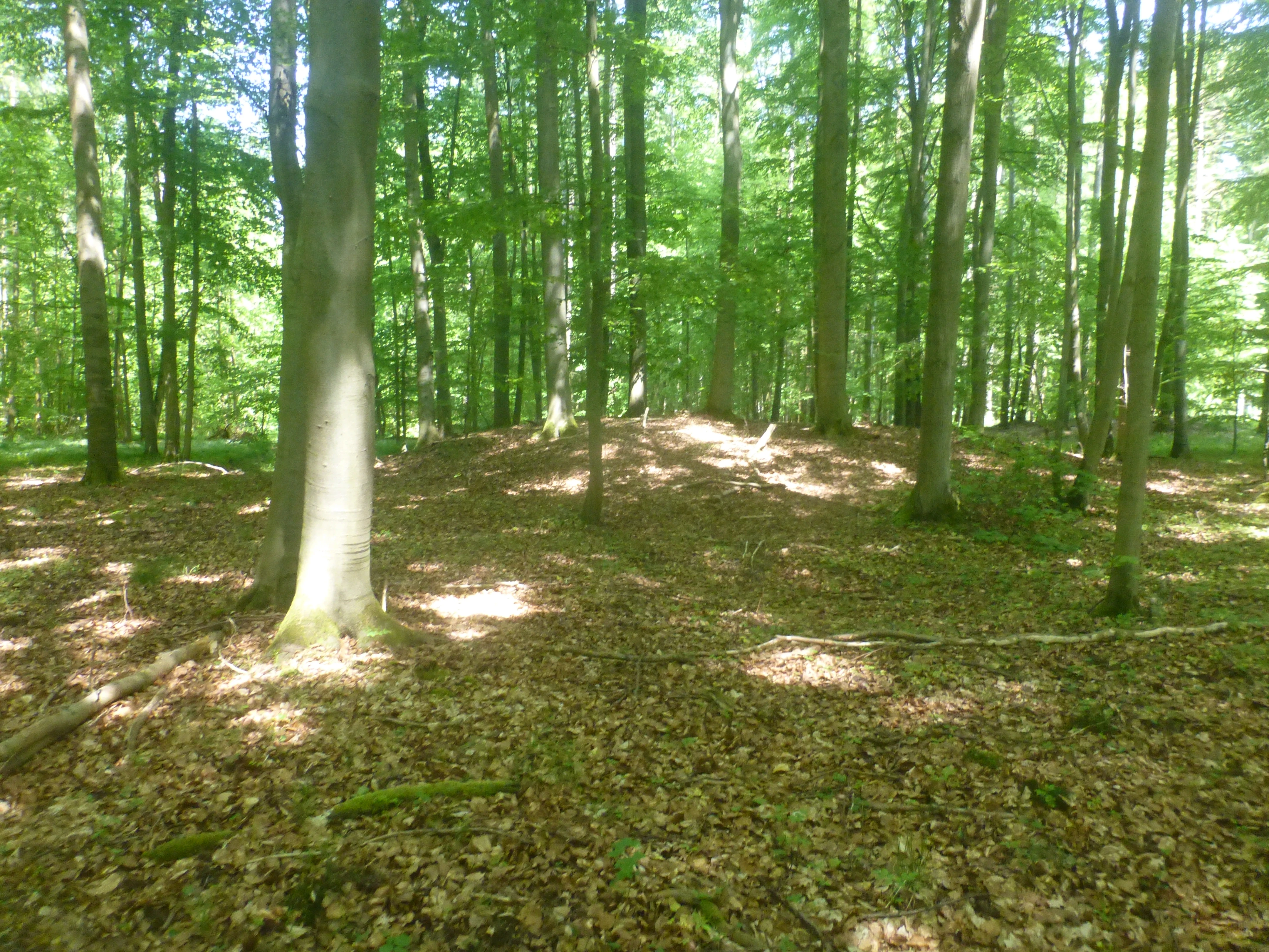
A slightly raised earthen mound surrounded by tall deciduous trees in a forest with a leafy ground cover.
Historical burial mound located within the beech forest of Kühmstedter Berg.

Kühmstedter Berg history and protected-area timeline

The formal protection of the Kühmstedter Berg area dates back to 1961, when the roughly 38-hectare site was designated as a nature reserve (Naturschutzgebiet) under the identifier 16. This placed the wooded ridge into the broader German conservation framework that aimed at preserving representative examples of regional forest communities in central Thuringia.

Long before formal protection, however, the hill already carried a deep human imprint. On its broad, flat ridge lies one of the larger tumulus cemeteries of the former Mühlhausen district, with at least fifteen burial mounds dating to the period between roughly 1600 and 1300 BCE. The site remains under archaeological monument protection today.

In the early medieval period, the area below the ridge, in what is called the Kühmstedter Grund, hosted a small village. It first appears in written records in 1280, when a local knight named Heinrich von Lengefeld (called Wendephafe) and his nephew Reinhard von Ammern sold the settlement of "Kemestete" to the Brückenkloster Mühlhausen. They were likely vassals of Count Albert von Gleichenstein, whose seal confirmed the transaction. The village was apparently abandoned not long afterward.

During the 14th century, the Mühlhäuser Landgraben was constructed along the northwestern edge of the hill. This defensive earthwork formed the boundary between the Free Imperial City of Mühlhausen and the Eichsfeld, which belonged to the Electorate of Mainz. A road-controlled passage called the Lengefelder Warte was built into the line, and these earthworks and ditches remain clearly visible on the ground today, accessible via a hiking trail.

Kühmstedter Berg landscape and geographic character

Kühmstedter Berg is a low, plateau-shaped ridge reaching roughly 300 to 360 meters in elevation, defined more by its gentle relief and valley incisions than by dramatic topography. To the north the land drops into the Unstrut valley, and to the south it descends toward the small stream valley of the Kühmstedter Bach, creating a broad, flat-topped hill framed by two contrasting lowlands.

The underlying rock is Upper Muschelkalk, a limestone-dominated unit typical of much of the Thuringian Basin margin, while a layer of Lower Keuper lies just to the south along the Lange Mark. This calcareous base supports the dry, warm-loving forest community that defines the hill. The western boundary of the area is essentially drawn by the course of the Mühlhäuser Landgraben, a long, narrow earthwork that still shapes the terrain.

Forested land dominates the central and northern slope of the hill, producing a continuous woodland cover that visually anchors the reserve. The eastern slopes and southern margins sit at the edge of agricultural land use, giving the protected area a clear forest-to-field transition. Small water features, like the shallow pond along a path within the reserve, add further texture to the otherwise modestly undulating terrain.
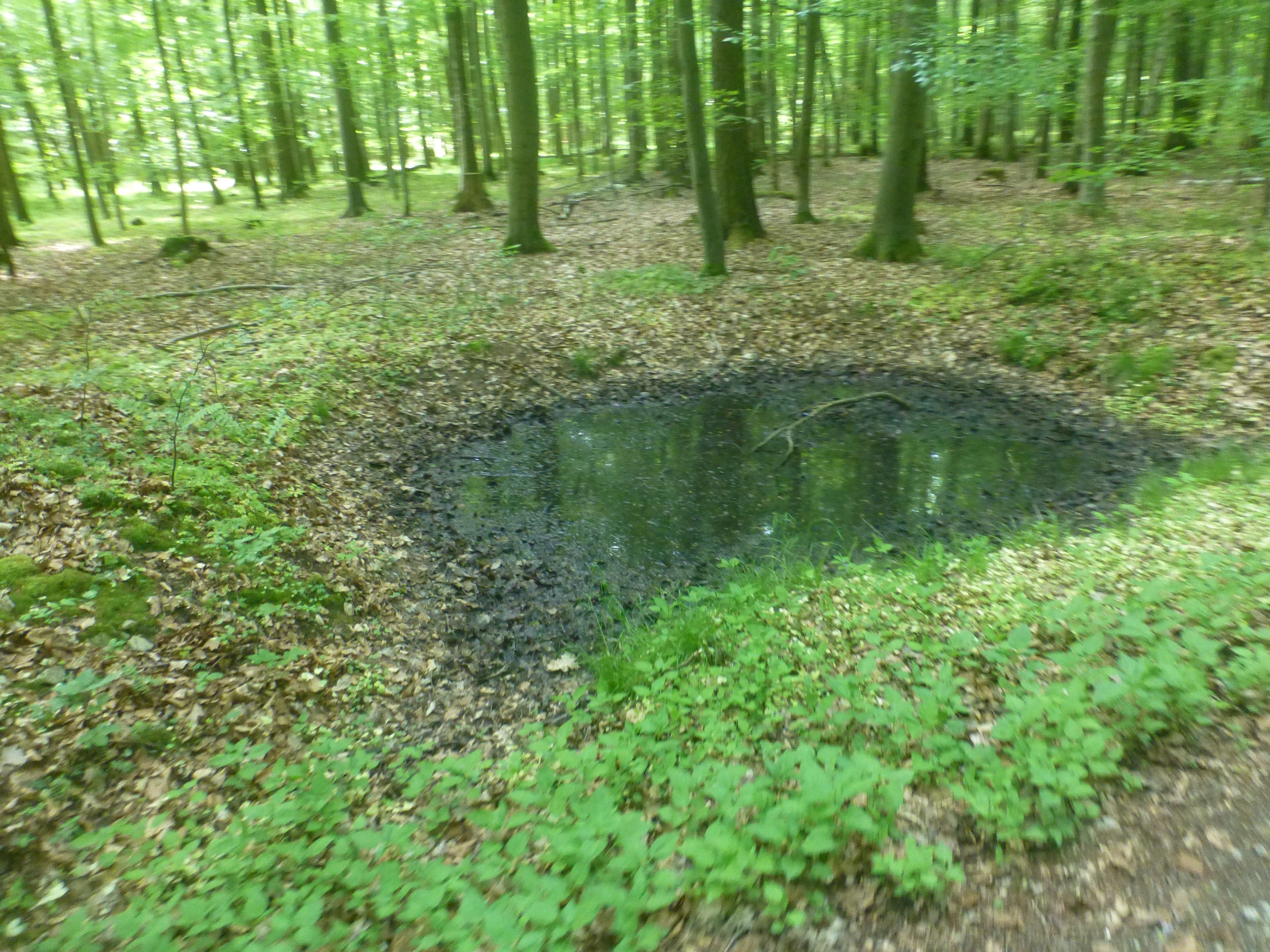
A small, muddy pond surrounded by deciduous trees and leaf litter in a temperate forest setting.
A small pond nestled within the forest of the Kühmstedter Berg nature reserve.

Kühmstedter Berg ecosystems, habitats, and plant life

The defining ecological character of Kühmstedter Berg is its beech-rich oak and hornbeam woodland (Eichen-Hainbuchenwald) growing on the calcareous soils of the Muschelkalk. This forest type is characteristic of the warmer, drier hill margins that mark the transition from the Eichsfeld uplands into the Thuringian Basin, and the reserve preserves a coherent example of this habitat.

Woodland dominates the heart of the hill, with the central and northern parts of the slope remaining under closed forest cover. In contrast, the eastern slopes and the southern rim open up into agricultural land, creating an ecotone between forest and field that is itself ecologically valuable for many edge-adapted species.

Moisture variation across the hill contributes additional habitat diversity. Small topographical depressions and pools, like the shallow roadside pond within the reserve, retain water after rain and support moisture-loving plants that differ from the drier forest floor elsewhere. The combination of calcareous substrate, varied light exposure, and the forest-field boundary gives the nature reserve a mix of habitat conditions in a compact area.

Kühmstedter Berg wildlife and species highlights

The protected woodland of Kühmstedter Berg provides habitat for the typical fauna of lowland central European oak and hornbeam forests, including the small mammals, woodland birds, and insect communities associated with mature mixed broadleaf canopies. The reserve's modest size and continuity with surrounding forest fragments mean it functions as a refuge and stepping stone within the broader agricultural landscape of the Thuringian Basin.

The transition zones along the forest edges and along the stream valleys of both the Unstrut and the Kühmstedter Bach support additional wildlife, particularly woodland-edge birds and invertebrates that benefit from the proximity of open agricultural land. The damp hollows and small water bodies in and around the reserve also create local conditions for amphibians and aquatic invertebrates.

Kühmstedter Berg conservation status and protection priorities

Kühmstedter Berg has been formally protected since 1961 as a designated nature reserve (Naturschutzgebiet), placing it under the strict conservation regime of German nature protection law. Its designation reflects the regional importance of its beech-rich oak and hornbeam forest on calcareous Muschelkalk soils, a habitat type that has lost much of its extent to historical land use elsewhere in central Thuringia.

Within the system of protected areas of the Unstrut-Hainich-Kreis, the reserve carries the identifier 16, alongside other protected sites such as the Flachstal, the Grabsche Berge, Großer Horn, Herbslebener Teiche, Klosterschranne and Faulunger Stein, Sonder, the Unstruttal between Nägelstedt and Großvargula, Volkenroder Wald, and Zimmerbachtal-Hellerbachtal. Together, these sites preserve representative forest, grassland, aquatic, and valley habitats across the district.

The reserve's conservation value extends beyond the forest itself. The protection of the wooded ridge also preserves the integrity of the surrounding landscape context, including the Mühlhäuser Landgraben earthworks and the Bronze Age tumulus field, both of which benefit from the exclusion of intensive land use within the reserve boundary.

Kühmstedter Berg cultural meaning and human context

The cultural landscape around Kühmstedter Berg reflects centuries of layered human presence on a modest hill that has long served as a transition between administrative and natural regions. The Bronze Age tumulus cemetery on the ridge, with at least fifteen burial mounds, links the site to the prehistoric occupation of the Eichsfeld and Thuringian Basin, while the medieval settlement of "Kemestete" in the Kühmstedter Grund, first documented in 1280, points to a village landscape that was later abandoned.

The Mühlhäuser Landgraben running along the western edge is among the most distinctive cultural features of the area. Built in the 14th century as a boundary fortification of the Free Imperial City of Mühlhausen against the Electorate of Mainz territory of the Eichsfeld, this earthwork remains clearly visible in the terrain and is accessible via a hiking trail. The Lengefelder Warte, a controlled passage through the line, marks the former road crossing point. Together these heritage elements tie the protected natural area into the broader historical identity of the region between Mühlhausen and the Eichsfeld.

Top sights and standout views in Kühmstedter Berg

Kühmstedter Berg offers a compact combination of natural and cultural heritage within a small protected area. The reserve's beech-rich oak and hornbeam forest on Muschelkalk bedrock represents one of the characteristic woodland types of the Thuringian Basin margin.

Equally notable are the archaeological and medieval features preserved on and around the ridge, including the Bronze Age tumulus cemetery and the preserved stretches of the Mühlhäuser Landgraben. The result is a hill that protects not only forest habitat but also visible traces of how the Thuringian landscape has been inhabited, defended, and farmed over many centuries.

Best time to visit Kühmstedter Berg

The Kühmstedter Berg reserve can be visited in any season without the kind of severe weather barriers that affect higher mountain parks, but the character of the experience changes with the time of year. Late spring brings fresh green canopies to the oak and hornbeam forest and makes the small pools and damp hollows along the paths most visible. Summer offers the deepest shade under the broadleaf trees and the longest daylight for exploring both the woodland trails and the adjacent earthworks of the Mühlhäuser Landgraben.

Autumn is particularly atmospheric on the hill, with the mixed broadleaf forest turning color and the agricultural fields at the eastern and southern margins in harvest. Winters are generally mild by German standards in this part of Thuringia, and the open agricultural fringes and the preserved Mühlhäuser Landgraben offer clearer views through the bare deciduous canopy, making archaeological features easier to see.


Monthly climate preview

Monthly temperature ranges and precipitation rhythm from 1991 to 2020

Kühmstedter Berg Climate Normals and Long-Term Temperature Patterns

Historical meteorological data records monthly temperature variations and precipitation averages across representative coordinates in Thuringia. Examining the complete twelve-month profile provides deeper insight into measured long-term climatic conditions.
Annual mean8 °C
-1 °C18 °C
Jan-1°
Feb-1°
Mar
Apr
May12°
Jun15°
Jul18°
Aug18°
Sep13°
Oct
Nov
Dec
Warmest month
July

17.7 °C

Coolest month
January

-1.4 °C

Wettest month
July

2.8 mm/day

Driest month
April

1.5 mm/day

Park location guide

Geography guide, regional context, and park location map for Kühmstedter Berg

Kühmstedter Berg park geography, regions, and map view in Germany

Understand where Kühmstedter Berg sits in Germany through a broader geographic reading of the surrounding landscape, nearby location context, and its mapped position within the national park landscape.

How Kühmstedter Berg fits into Germany

Germany is a federal republic in Western and Central Europe with a population of over 83 million across sixteen constituent states. It is Europe's largest economy by nominal GDP and a major global exporter and importer. The capital is Berlin, and the country borders Denmark, Poland, Czech Republic, Austria, Switzerland, France, Luxembourg, Belgium, and the Netherlands.

Wider geography shaping Kühmstedter Berg in Germany

Germany is located in Western and Central Europe, spanning 357,022 km². It borders Denmark to the north, Poland and the Czech Republic to the east, Austria and Switzerland to the south, and France, Luxembourg, Belgium, and the Netherlands to the west. The country has coastlines on the Baltic Sea and North Sea to the north, with the Alps located in the southern region.

Map view of Kühmstedter Berg

Use this park location map to pinpoint Kühmstedter Berg in Germany, understand its exact geographic position, and read its mapped placement within the surrounding landscape more clearly.

Pigeon | © OpenStreetMap contributors

Location context for Kühmstedter Berg

Thuringia

Visualizing the wooded ridge, Muschelkalk geology, and forest habitats of Kühmstedter Berg

Kühmstedter Berg Photos and Protected Area Landscapes in Thuringia

Photographic records document the dense canopy, gentle elevation changes, and woodland habitats defining Kühmstedter Berg. Visual references reveal the protected terrain, transitional geography, and historical landscape boundaries across the Thuringian reserve.

A slightly raised earthen mound surrounded by tall deciduous trees in a forest with a leafy ground cover.

A panoramic view of a green grassy field with a dirt path leading toward a dense treeline under a clear blue sky.

A small, muddy pond surrounded by deciduous trees and leaf litter in a temperate forest setting.

Park atlas

Compare nearby woodlands, limestone ridges, and protected regional landscapes

Parks Near Kühmstedter Berg and Protected Areas Across the Surrounding Region

Browse other parks and protected areas situated near Kühmstedter Berg to examine related woodland ecology and limestone ridge terrain. Expanding the geographic comparison provides broader context on the transitional landscapes connecting the Thuringian Basin and surrounding uplands.
Watercolor painting of a green, rolling valley with muted pastel tones.
Nature reserveThuringia
About 8.4 km away#1 closest

East

Flachstal Nature Reserve: Geographic Profile and Protected Valley Landscapes in Thuringia

Ecologically rich calcareous dry valley and protected habitat mosaic

Flachstal represents a significant nature reserve within Thuringia, defined by its steep flanks of Muschelkalk limestone and centuries of traditional sheep grazing. This dry valley functions as both a hotspot for grassland species and a vital climate corridor for the surrounding plateau. The site offers an opportunity to study the intersection of geological history, fossil-rich streambeds, and modern conservation management within the Natura 2000 network.

Area
1.876 km²
Established
1999
IUCN
IV
Relief
Upland
A wide watercolor painting showing a gentle river winding through green hills with pink flowering trees and pale blue mountains in the background.
Nature reserveUnstrut-Hainich-Kreis
About 12 km away#2 closest

Southwest

Klosterschranne, Faulunger Stein Nature Reserve: Mapped Boundaries and Regional Geography

A protected Muschelkalk valley landscape in the Thuringia region

Klosterschranne, Faulunger Stein consists of a protected woodland and rock environment shaped by limestone erosion. The reserve features sharp valley spurs, calcareous springs, and cliffs that rise up to thirty meters, anchoring a larger network of habitats within the Upper Eichsfeld plateau. Users can examine the layered conservation status and distinct topographic features that define this ecologically significant German site.

Area
2.983 km²
Established
1996
IUCN
IV
Relief
Mountain
Watercolor painting of green rolling hills, forested slopes, and light-colored rocky outcrops in a rural landscape.
Nature reserveThuringia
About 13 km away#3 closest

West

Ibenkuppe Nature Reserve and the Muschelkalk Cuesta Landscapes of Thuringia

Mapped protected woodland and limestone escarpment geography

Located in the Eichsfeld district, Ibenkuppe is a nature reserve that protects a significant Muschelkalk spur. Its geography includes the prominent Abrißwand landslide scar and the deeply cut Rosoppe valley. This site provides a focused look at the intersection of forested limestone slopes and traditional valley pasture fragments in the heart of Germany.

Area
0.292 km²
Established
1997
Relief
Mountain
Scope
Terrestrial
A horizontal watercolor painting showing rolling green and yellow hills with distant purple-toned forests against a white background.
Nature reserveThuringia
About 13 km away#4 closest

Northeast

Keulaer Wald Nature Reserve: Geographic Overview of the Dün Plateau Forest in Thuringia

Mapped beech-dominated plenterwald and limestone escarpment terrain

Located in northern Thuringia, Keulaer Wald is a designated nature reserve characterized by its continuous beech canopy on shell limestone bedrock. This site serves as a vital protected area within the regional forest belt, offering high-elevation viewpoints over the surrounding Eichsfeld Basin and the distant Harz mountain range.

Area
2.97 km²
Established
1961
Relief
Mountain
Climate
Temperate
A watercolor painting showing a panorama of soft green rolling hills and meadows under a hazy, pale sky.
Nature reserveThuringia
About 13 km away#5 closest

Southeast

Grabsche Berge Nature Reserve: Thuringia Protected Hill and Cuesta Geography

Steppe-like terrain within the Thuringian Basin

The Grabsche Berge nature reserve encompasses a series of low hills forming a notable cuesta landscape in central Germany. This protected area provides a focal point for understanding dry grassland vegetation and geological transitions on the edge of the Unstrut floodplain, offering a distinct botanical and environmental study site in the heart of the Thuringian Basin.

Area
0.544 km²
Established
1996
Nature reserveThuringia
About 16 km away#6 closest

Southwest

Werrahänge von Frankenroda bis Falken: A Deep Dive into Thuringian Protected Landscapes

Mapping limestone river canyons and unique forest habitats in Wartburgkreis.

This protected area captures a distinct geomorphological intersection of river-cut canyons and plateau ridges in Thuringia. The site preserves an intense mosaic of juniper heath, dry grasslands, and ancient beech forests, functioning as a vital link for species conservation. Examine the mapped boundaries, karst features, and the sculptural topography formed by the Werra river as it winds through the Muschelkalk rim of the Thuringian Basin.

Area
5.69 km²
Established
1999
IUCN
IV
Relief
Upland
A horizontal watercolor painting depicting a soft-toned, layered landscape of rolling hills and forests in shades of green and pale yellow.
Nature reserveThuringia
About 17 km away#7 closest

Southwest

Adolfsburg, Bornberg, Sülzenberg: A Protected Muschelkalk Landscape in Thuringia

Geographic map and protected-area atlas context

This nature reserve stands as a prominent geological feature in the Werrabergland region, where steep Muschelkalk hills and plateaus meet the Werra valley. The site protects a rare assembly of habitats including juniper heathland, scree slopes, and old-growth orchards, offering a dense case study for regional botanical diversity and limestone-terrain mapping in central Germany.

A soft watercolor illustration depicting layered green and pale pink rolling hills under a light sky.
Protected areaThuringia
About 18 km away#8 closest

Northeast

Bleicheröder Berge: Geographic Profile and Protected Landscape Context in Thuringia

Mapping the forested ridges and Muschelkalk geology of the Thuringian region.

Investigate the Bleicheröder Berge as a vital protected area in Thuringia. This resource outlines the range's formation as a series of isolated hill remnants, its fossil-bearing limestone cliffs, and the botanical diversity characterizing its beech forests and rare orchid populations.

Area
16 km²
Relief
Mountain
Climate
Temperate
Access
Easy access

Common questions about visiting, size, designation, and location context for Kühmstedter Berg

Kühmstedter Berg FAQs for park facts, access, geography, and protected area context

Find quick answers about Kühmstedter Berg, including protected-area facts, park geography, trail and visitor context, and how the park fits into its surrounding country and regional landscape.
MoriAtlas Explorer

Continue Your Protected Areas Search Across the Global Atlas

Deepen your exploration by continuing the structured search for national parks and protected areas worldwide. Utilize the comprehensive filtering capabilities to compare different conservation landscapes and refine your understanding of global park geography. Discover more about the distribution and characteristics of protected natural areas.

Global natural geography