

Mori Atlas logo
State or regional parkKwadacha Wilderness Provincial Park

Mapping the unroaded mountain terrain and remote wilderness boundaries of northern British Columbia

Kwadacha Wilderness Provincial Park: A Comprehensive Geographic Atlas and Protected Landscape Overview

Spanning over 130,000 hectares of rugged northern Rocky Mountain territory, Kwadacha Wilderness Provincial Park stands as a prime example of strict wilderness preservation in British Columbia. This expansive, roadless landscape is defined by its high-relief peaks, deep forested valleys, and intricate river systems that remain largely inaccessible to casual travel. As a critical component of the Muskwa-Kechika Management Area, the park offers a distinct study in isolated mountain ecosystems and pristine northern geography.

wilderness arearoadless parkmountain landscaperemote backcountryMuskwa-KechikaBritish Columbia

Kwadacha Wilderness Provincial Park

State or regional park

Park overview

Structured park overview, official facts, and landscape profile for Kwadacha Wilderness Provincial Park

Kwadacha Wilderness Provincial Park park facts, protected area profile, and essential visitor context

Review the core facts for Kwadacha Wilderness Provincial Park, including designation, size, terrain, visitor scale, habitats, and operating context in one park-focused overview.

About Kwadacha Wilderness Provincial Park

Kwadacha Wilderness Provincial Park represents the kind of large, roadless, mountainous wilderness that has become increasingly rare in southern Canada. Covering more than 130,000 hectares in northeastern British Columbia, the park sits deep within the northern Rocky Mountains, where high ridges, river-cut valleys, and northern forests combine into a continuous wilderness landscape. It is one of several adjoining protected areas that together form the backbone of the Muskwa-Kechika Management Area, a massive conservation and land-use framework spanning much of northern BC.

The park's setting shapes every aspect of its character. The nearest road, the Alaska Highway, lies roughly 150 kilometers away overland, and reaching the park on foot requires about 12 to 14 days of sustained backpacking through river crossings and difficult terrain. For most visitors, access is by small aircraft landing at remote strips or by multi-day horseback riding expeditions. This logistical barrier is not an incidental feature; it is central to what Kwadacha is, a place where isolation, solitude, and the absence of development are part of the protected experience itself.

Ecologically, the park is positioned at the intersection of northern Rocky Mountain and boreal-influenced landscapes. Its elevation range, forests, and waterways support a rich mix of fauna typical of remote northern BC wilderness, including more than 70 recorded bird species and mammals such as bears, wolves, and small northern specialists like the Siberian lemming. Because there are no roads, trails, or facilities, the park is intentionally managed as a walk-in or fly-in wilderness, with camping allowed for self-sufficient travelers at any time of year.

In the broader provincial and national context, Kwadacha contributes to a critical conservation story: the preservation of a vast, interconnected wildlife landscape in a region where resource extraction, forestry, and other land uses remain active. Its IUCN Category Ib wilderness designation reflects this intent, placing Kwadacha among Canada's most strictly preserved landscapes and giving it an enduring role in debates over wilderness protection in the province.

Quick facts and research context for Kwadacha Wilderness Provincial Park

Kwadacha Wilderness Provincial Park is a provincial park of approximately 130,279 hectares located in the Peace River Regional District of northeastern British Columbia. It was established on May 18, 1973, and is classified as an IUCN Category Ib wilderness area, a designation used for large, unmodified or lightly modified ecosystems managed to retain their natural character.

The park is managed by BC Parks and forms part of the Muskwa-Kechika Management Area, a major multiple-use landscape framework in northern BC. It lies south of Northern Rocky Mountains Provincial Park and Stone Mountain Provincial Park, contributing to a large unroaded wilderness block adjacent to the Alaska Highway corridor. There is no road access into the park, and it is reached by air, horseback, or extended backpacking.

Protection and recognition

Documented terrestrial protection scope and international recognition data

Kwadacha Wilderness Provincial Park Protection Status and Recognition

Kwadacha Wilderness Provincial Park maintains a documented terrestrial protection scope within the regional protected area network. Official records outline its conservation designation parameters and international recognition frameworks without implying specific management outcomes.

Protection details

Protection scope
Terrestrial
Transboundary protection
No
Park context

Deeper park guide and search-rich context for Kwadacha Wilderness Provincial Park

Kwadacha Wilderness Provincial Park history, landscape, wildlife, and travel context

Explore Kwadacha Wilderness Provincial Park through its history, landscape character, ecosystems, wildlife, conservation priorities, cultural context, and seasonal travel timing in a structured park guide built for atlas discovery and search intent.

Why Kwadacha Wilderness Provincial Park stands out

Kwadacha Wilderness Provincial Park is best known as one of the most inaccessible wilderness parks in British Columbia, defined by its complete absence of road access and its scale of untouched mountain terrain. The park's identity is rooted in the Muskwa-Kechika Management Area, a signature landscape conservation initiative in Canada's northern Rockies. The park stands out for the combination of large protected area size, rugged topography, and the ruggedness of approach. Visitors who do reach Kwadacha typically fly in to remote gravel airstrips or ride in by horseback, making it a destination for true backcountry travelers rather than casual sightseers. Birdlife, large mammals such as bears and wolves, and the presence of uncommon northern species like the Siberian lemming contribute to its ecological reputation.

Kwadacha Wilderness Provincial Park history and protected-area timeline

Kwadacha Wilderness Provincial Park was formally established on May 18, 1973, as a provincial park in British Columbia. Its creation reflected an early recognition that the mountainous terrain of northeastern BC contained landscapes of significant wilderness value that warranted protection from road building and development.

Over time, the park became integrated into the broader Muskwa-Kechika Management Area, a regional land-use framework that coordinates conservation and resource activities across a large portion of northern British Columbia. Through this integration, Kwadacha strengthened its role as a wilderness anchor within a much larger landscape-level conservation system, linking northward to Northern Rocky Mountains Provincial Park and Stone Mountain Provincial Park.

Since its establishment, the park has remained under the management of BC Parks and has retained its character as a roadless wilderness area, with access only by aircraft, horseback, or extended backcountry travel.

Kwadacha Wilderness Provincial Park landscape and geographic character

Kwadacha Wilderness Provincial Park is dominated by mountainous terrain, with much of its 130,000-plus hectares described as rugged, high-relief country typical of the northern Rocky Mountains. Ridges, peaks, and deep valleys shape the terrain, while forests clothe the lower slopes and valley bottoms. The park lies well south of the community of Fort Nelson, giving it a distinctly remote interior position away from settled areas.

The landscape is defined by the difficulty of moving through it. Rivers draining from the park's mountains create natural barriers, and backcountry travelers describe the river crossings as treacherous, particularly during seasonal high water. There are no roads, bridges, or marked trail systems within the park boundary, reinforcing the impression of a continuous, unfragmented wilderness.

At higher elevations the terrain transitions toward more open alpine and subalpine environments, while the valley floors and lower slopes support boreal and northern forest types characteristic of the region. This vertical and ecological layering gives Kwadacha a varied topography within a relatively compact regional setting.

Kwadacha Wilderness Provincial Park ecosystems, habitats, and plant life

The park's natural setting reflects its position in the northern interior of British Columbia, where the Rocky Mountains meet northern forest ecosystems. Elevations range from forested valley corridors to subalpine ridges, creating a layered environment that supports both montane and boreal ecological influences. Wildlife habitat within the park is largely shaped by these elevational transitions, with valley bottoms providing winter range and security cover for large mammals, and higher terrain offering summer foraging and migration corridors.

Because Kwadacha is unroaded and largely undeveloped, the ecosystems within it retain a high degree of naturalness. River systems draining the mountains are important features of the landscape, supporting riparian vegetation and structuring wildlife movement across the park. The combination of intact forests, mountainous topography, and clean water systems makes the park a significant contributor to ecological connectivity in the broader Muskwa-Kechika region.

Kwadacha Wilderness Provincial Park wildlife and species highlights

Kwadacha Wilderness Provincial Park supports a rich and characteristic assemblage of northern Rocky Mountain wildlife. More than 70 bird species have been recorded in and around the park, reflecting the diversity of habitats provided by its mountains, forests, and waterways. Birdlife draws from both montane and boreal faunas, giving the park a transitional character for avian species typical of this part of Canada.

Among mammals, the park is known for healthy populations of large carnivores and ungulates typical of the region. Bears, both grizzly and black, and wolves roam the wilderness valleys and slopes, taking advantage of the unbroken habitat that stretches north into adjacent protected areas. Smaller but distinctive species also occur, including the Siberian lemming, a small northern mammal that emphasizes the park's position at the edge of northern and alpine faunal zones.

The combination of large carnivores, ungulates, and a long list of bird species reflects an ecosystem with relatively little human disturbance, where predator-prey relationships and seasonal migrations still play out across a connected landscape. This wildlife profile is one of the defining reasons the park has been preserved as a wilderness area.

Kwadacha Wilderness Provincial Park conservation status and protection priorities

Kwadacha Wilderness Provincial Park holds significant conservation value because of its scale, its intactness, and its role within the Muskwa-Kechika Management Area, one of North America's most notable large-landscape conservation frameworks. Holding more than 130,000 hectares of essentially unroaded wilderness, the park helps maintain ecological processes such as movement, migration, and predator-prey dynamics across an enormous unbroken region in northeastern British Columbia.

The park's IUCN Category Ib wilderness designation reflects a deliberate policy choice: the area is managed to remain essentially unmodified, with no roads or permanent facilities and only minimal human presence. This status protects not only the park itself but also its function as a refuge for wide-ranging species such as bears and wolves that depend on large, connected habitat blocks.

In the wider context of resource-rich northern BC, where forestry, mining, and energy development are active land uses, Kwadacha stands as a counterweight: a strictly protected core within a multiple-use region. Its long-term conservation importance lies as much in what is absent from it, roads, settlements, and permanent infrastructure, as in the wildlife and landscapes it preserves.

Top sights and standout views in Kwadacha Wilderness Provincial Park

Kwadacha Wilderness Provincial Park is a signature example of strict wilderness protection in British Columbia, distinguished by its complete absence of roads and its integration into the Muskwa-Kechika Management Area. Its scale of more than 130,000 hectares, combined with its mountainous terrain and unaltered ecosystems, gives it an outsized role in regional conservation.

Equally notable is the rarity of the experience it offers: with no road access and no facilities, every visit requires self-sufficiency, whether by aircraft, horseback, or extended backpacking. This combination of ecological value and logistical challenge makes Kwadacha one of the most uncompromising wilderness destinations in the Canadian Rockies.

Best time to visit Kwadacha Wilderness Provincial Park

Because the park is roadless and only accessible by aircraft, horseback, or long backcountry travel, the practical character of a visit depends heavily on weather and seasonal conditions. Summer and early fall typically offer the most viable travel window, when rivers may be lower and conditions for backpacking or horseback travel are generally more favorable, though river crossings can still be hazardous.

Winter transforms the park into a much more demanding landscape, where heavy snow, extreme cold, and limited daylight add significant risk to any travel beyond short ski or snowshoe outings. The park is open year round, but visitors normally time their trips to align with stable weather windows, longer daylight hours, and conditions suited to their chosen mode of access.
Monthly climate preview

Long-term representative point measurements tracking annual temperature and precipitation

Kwadacha Wilderness Provincial Park Climate Normals and Weather by Month

Kwadacha Wilderness Provincial Park records documented monthly temperature variations and precipitation rates across a representative elevation of 1671 meters. Detailed twelve month climate profiles provide comprehensive analytical context for regional environmental monitoring.
Annual mean-5 °C
-16 °C8 °C
Jan-16°
Feb-15°
Mar-13°
Apr-7°
May
Jun
Jul
Aug
Sep
Oct-6°
Nov-14°
Dec-16°
Warmest month
July

8.4 °C

Coolest month
January

-16.4 °C

Wettest month
June

4.5 mm/day

Driest month
February

1.5 mm/day

Park location guide

Geography guide, regional context, and park location map for Kwadacha Wilderness Provincial Park

Kwadacha Wilderness Provincial Park park geography, regions, and map view in Canada

Understand where Kwadacha Wilderness Provincial Park sits in Canada through a broader geographic reading of the surrounding landscape, nearby location context, and its mapped position within the national park landscape.

How Kwadacha Wilderness Provincial Park fits into Canada

Canada is a federal parliamentary constitutional monarchy spanning North America from the Atlantic to the Pacific and Arctic Oceans. With a population of over 41 million, it is officially bilingual in English and French at the federal level. The country gained independence from the United Kingdom through a gradual process culminating in 1982.

Wider geography shaping Kwadacha Wilderness Provincial Park in Canada

Canada occupies the northern portion of North America, sharing its longest international border with the United States. The country extends from the Atlantic Ocean to the Pacific Ocean and northward into the Arctic Ocean, giving it the longest coastline of any nation.

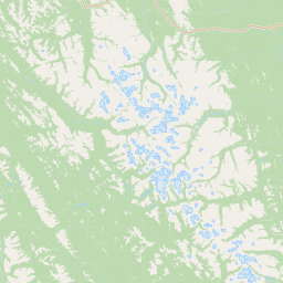
Map view of Kwadacha Wilderness Provincial Park

Use this park location map to pinpoint Kwadacha Wilderness Provincial Park in Canada, understand its exact geographic position, and read its mapped placement within the surrounding landscape more clearly.

Pigeon | © OpenStreetMap contributors

Location context for Kwadacha Wilderness Provincial Park

British Columbia
Recorded earthquake history

Explore Historical Earthquake Records for Kwadacha Wilderness Provincial Park

Review a structured dataset of recorded seismic activity occurring near the vast, mountainous landscape of Kwadacha Wilderness Provincial Park. Provided by MoriAtlas, this historical collection offers clear insights into regional seismic events and their proximity to this remote northern wilderness area.

Kwadacha Wilderness Provincial Park Earthquake History

Catalogued events

1 event

Strongest magnitude

Magnitude 4.3

Most recent event

Jun 7, 2012

This history includes earthquakes recorded inside the park or within 50 km of its borders

Park atlas

Compare adjacent protected landscapes and northern mountain environments in British Columbia

Exploring Other Parks Near Kwadacha Wilderness Provincial Park and Surrounding Wilderness Reserves

Compare adjacent protected landscapes and rugged mountain reserves after reviewing Kwadacha Wilderness Provincial Park. Broaden your geographic perspective by examining connected northern wilderness areas across the region.
State or regional parkBritish Columbia
32 km away#1 closest

Southeast

Redfern-Keily Provincial Park: A Deep Dive into Muskwa Ranges Protected Geography

Remote Glacial Landscapes and Northern Wilderness Terrain

Redfern-Keily Provincial Park encompasses a significant stretch of remote wilderness in the Muskwa Ranges of northeastern British Columbia. Anchored by the eight-kilometer Redfern Lake and surrounding glaciers like the Ithaca and Achaean, the area serves as a primary example of intact boreal and subalpine geography. The terrain offers a rugged look at high-elevation ecosystems and glacial history within the Muskwa-Kechika Management Area.

Area
807.12 km²
Established
1999
IUCN
II
Relief
Mountain
State or regional parkBritish Columbia
About 35 km away#2 closest

East

Prophet River Hot Springs Provincial Park: Protected Landscape and Geothermal Geography

Remote backcountry wilderness in northeastern British Columbia

Prophet River Hot Springs Provincial Park is a specialized protected area known for its unique tufa mounds and geothermal features. Set against the mountainous backdrop of the Muskwa Ranges, this backcountry destination offers a compelling study of boreal and subalpine geography, accessible only by hiking or horseback through undisturbed wilderness corridors.

Area
1.84 km²
Established
1999
IUCN
II
Relief
Mountain
State or regional parkBritish Columbia
About 50 km away#3 closest

Southwest

Finlay-Russel Provincial Park and Protected Area: Mapping Northern British Columbia Wilderness

A remote river corridor in the Muskwa-Kechika Management Area.

Located in northern British Columbia, Finlay-Russel Provincial Park and Protected Area preserves an essential 85-kilometre river corridor along the Finlay River. This expansive wilderness territory serves as an integral part of the Muskwa-Kechika Management Area, showcasing deep boreal forest landscapes and rugged river valley terrain far from established road networks.

Area
1,092.05 km²
Established
2001
IUCN
II
Access
Remote access
State or regional parkBritish Columbia
About 77 km away#4 closest

Northwest

Dune Za Keyih Provincial Park and Protected Area: Watershed and Terrain Geography

Remote wilderness landscape in northern British Columbia

Dune Za Keyih Provincial Park and Protected Area protects the largest unlogged watershed in British Columbia. Situated within the Muskwa-Kechika Management Area, this remote wilderness is defined by the geological structures of the Rocky Mountain Trench, providing a continuous corridor of undisturbed mountain forest, riparian zones, and highland terrain.

Area
3,468.33 km²
Established
2001
IUCN
Ib
Relief
Mountain
State or regional parkBritish Columbia
110 km away#5 closest

Southeast

Graham-Laurier Provincial Park: Protected Boreal Landscape and Geographic Context

Remote wilderness exploration in the Peace River region

Graham-Laurier Provincial Park represents a massive, intact wilderness area in northeastern British Columbia. Defined by boreal forests, undulating ridges, and the cascading waters of Christina Falls, this region serves as a crucial natural refuge within the Muskwa-Kechika Management Area. Access is centered on rugged forest service roads and backcountry trails, making the area a primary destination for self-reliant exploration and terrain study.

Area
999.82 km²
Established
1999
IUCN
II
Relief
Mountain
State or regional parkBritish Columbia
122 km away#6 closest

Northwest

Denetiah Provincial Park and Protected Area: Regional Geography and Wilderness Mapping

An undisturbed boreal reserve in the Stikine Region

Discover the geographic structure of Denetiah Provincial Park and Protected Area, a vast roadless landscape in northern British Columbia. This park protects pristine boreal forests, elongated glacial lake basins, and critical river headwaters that serve as a benchmark for northern conservation within the Muskwa-Kechika Management Area.

Area
1,053.49 km²
Established
1999
IUCN
II
Relief
Upland
State or regional parkBritish Columbia
About 127 km away#7 closest

Southeast

Pink Mountain Provincial Park: Regional Geography and Protected Alpine Landscapes

Muskwa Foothills terrain and scientific conservation history.

Situated in the eastern foothills of the Rocky Mountains, Pink Mountain Provincial Park is defined by its transition from forested valleys to high-altitude tundra. This protected area stands as a unique ecological corridor, preserving major Mesozoic fossil sites and providing a habitat for diverse northern wildlife species that thrive in the cold-adapted vegetation of the Muskwa Foothills.

Area
0.98 km²
Established
1999
IUCN
II
Relief
Mountain
State or regional parkBritish Columbia
About 163 km away#8 closest

Northwest

Horneline Creek Provincial Park: Protected Canyon Landscapes and Rocky Mountain Trench Geography

Remote glacial-terrace wilderness in northern British Columbia

Located deep in the Rocky Mountain Trench, Horneline Creek Provincial Park is defined by its deep-cut canyon and ancient glacial terraces. This protected area offers an intimate view of sub-boreal terrain where mineral-stained walls and aspen-dotted grasslands create a concentrated, ecologically significant landscape within a remote corner of northern British Columbia.

Area
2.98 km²
Established
1999
IUCN
II
Relief
Upland

Common questions about visiting, size, designation, and location context for Kwadacha Wilderness Provincial Park

Kwadacha Wilderness Provincial Park FAQs for park facts, access, geography, and protected area context

Find quick answers about Kwadacha Wilderness Provincial Park, including protected-area facts, park geography, trail and visitor context, and how the park fits into its surrounding country and regional landscape.
MoriAtlas Explorer

Continue Your Protected Areas Search Across the Global Atlas

Deepen your exploration by continuing the structured search for national parks and protected areas worldwide. Utilize the comprehensive filtering capabilities to compare different conservation landscapes and refine your understanding of global park geography. Discover more about the distribution and characteristics of protected natural areas.

Global natural geography