
Mori Atlas logo
Nature reserveLahder Marsch

A critical wetland mosaic of flooded gravel pits and floodplain habitats within the Weseraue corridor.

Lahder Marsch Nature Reserve: Mapped Protected Landscapes in the Weser River Valley District

(Naturschutzgebiet Lahder Marsch)

Lahder Marsch represents a distinctive protected landscape situated in the Weser river valley, covering an area of former gravel extraction sites in northern Germany. As a core component of the Weseraue Bird Protection Area, this nature reserve functions as a vital wetland node for migratory and wintering waterbirds. The terrain is defined by open water basins, reed beds, and willow-lined shores, illustrating the ecological connectivity between local waterbodies and broader river floodplain networks in the Kreis Minden-Lübbecke district.

nature reservewetlandgravel pitswaterbird habitatWeser floodplainNatura 2000
Digital flat illustration of a peaceful lakeside forest scene with birch trees in the foreground, a small island, and a waterfall cascading from rocky hills in the distance.

Lahder Marsch

Nature reserve

Park overview

Structured park overview, official facts, and landscape profile for Lahder Marsch

Lahder Marsch park facts, protected area profile, and essential visitor context

Review the core facts for Lahder Marsch, including designation, size, terrain, visitor scale, habitats, and operating context in one park-focused overview.

About Lahder Marsch

Lahder Marsch is one of several protected wetland sites in the Petershagen area along the middle course of the Weser. Set in the broad Weser valley natural region, it occupies a stretch of lowland floodplain near the Bückeburger Aue tributary and represents a typical example of how former commercial extraction sites along German rivers have been converted into valuable nature reserves.

Although small in size, the reserve plays a meaningful role within the regional conservation landscape. It belongs to the Weseraue EU Bird Protection Area, which is itself part of the European Natura 2000 network, placing the site within an internationally recognized framework for the protection of wild birds and their habitats. The land is owned by the Kreis Minden-Lübbecke, giving the local district authority a direct role in managing and safeguarding the area.

The site is primarily an aquatic and wetland environment, shaped by post-extraction hydrology rather than by natural river dynamics alone. The interplay of standing water, vegetated shorelines, small islands, and surrounding agricultural land gives the reserve a diverse microhabitat structure in a compact area. Photographs from the site record small islands within the ponds as well as arable land at the edges of the protected zone, illustrating the typical mosaic of lowland Weser floodplain use.

Quick facts and research context for Lahder Marsch

Lahder Marsch is a statutory nature reserve officially numbered MI-034, located in the Kreis Minden-Lübbecke district and owned by that local authority. It lies within the municipality of Petershagen in the natural region of the Weser valley and is incorporated into the broader Weseraue EU Bird Protection Area, which is part of the Natura 2000 network.

The protected area covers approximately 19 hectares and centers on former gravel extraction sites in the lowland floodplain shared by the Weser river and the Bückeburger Aue tributary. Its conservation focus is on waterbird habitat, with characteristic features that include small islands, narrow peninsulas, willow fringe scrub, and reed beds surrounding the extraction ponds.

Protection and recognition

Explore documented conservation measures and management scope for Lahder Marsch

Lahder Marsch Protection Status and Official Designation Records

Examine the verified protection status and administrative designation records established for Lahder Marsch. Review available management data and formal recognition parameters structured for geographic analysis.

Protection details

Transboundary protection
No
Park context

Deeper park guide and search-rich context for Lahder Marsch

Lahder Marsch history, landscape, wildlife, and travel context

Explore Lahder Marsch through its history, landscape character, ecosystems, wildlife, conservation priorities, cultural context, and seasonal travel timing in a structured park guide built for atlas discovery and search intent.

Why Lahder Marsch stands out

Lahder Marsch is best known as a waterbird sanctuary set within a network of former gravel pits. The reserve's combination of open pit water bodies, small islands, and fringing reed and willow habitats provides breeding and resting conditions for several notable species, including Eurasian teal, garganey, and little grebe. The site's importance is heightened by its integration into the Weseraue Bird Protection Area, which links it to a much larger floodplain habitat complex along the Weser. This regional connectivity gives the small reserve an outsized role as a stepping stone for migratory and wintering waterfowl traveling through the Westphalian lowlands.
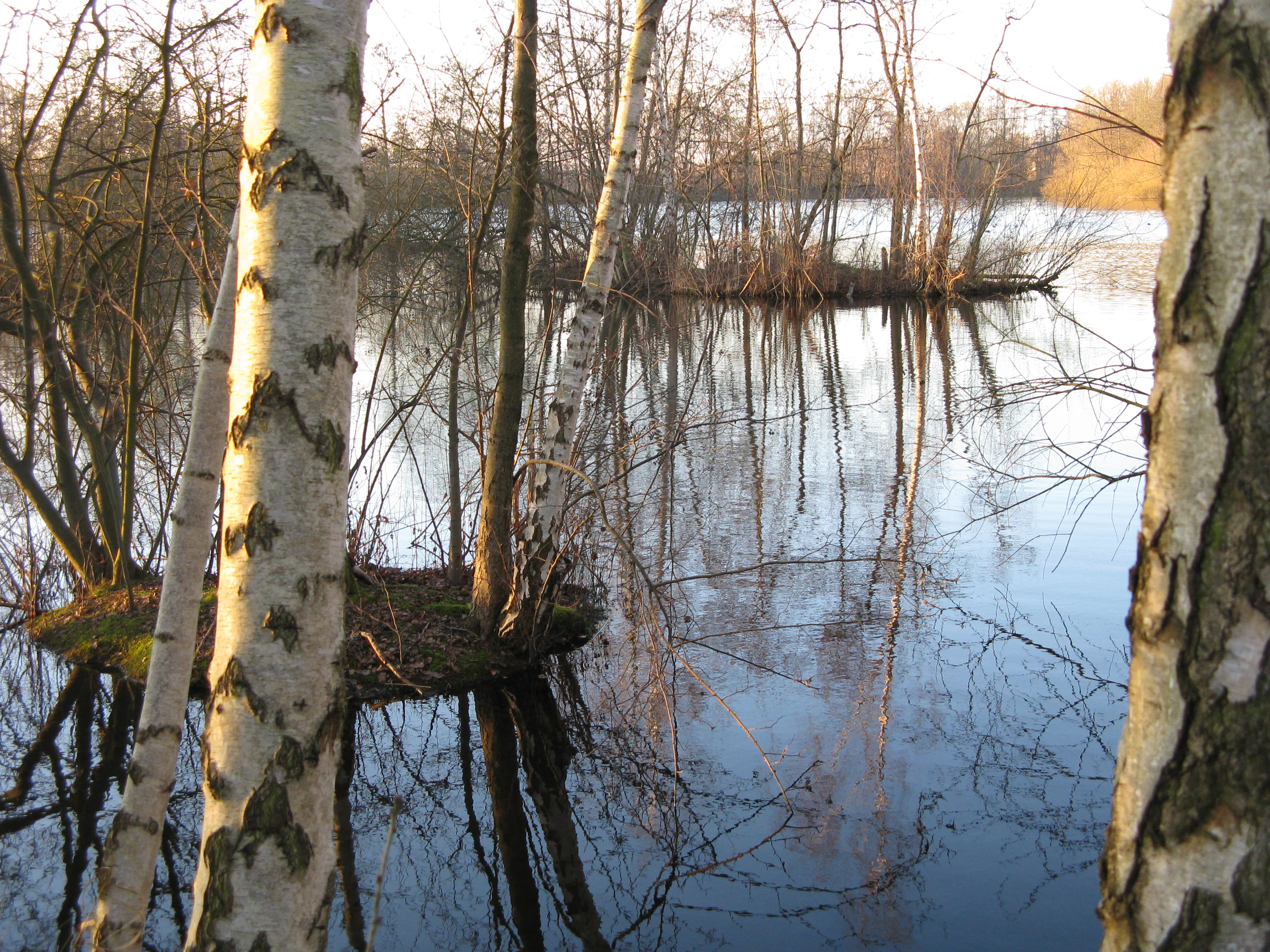
A calm pond with small, tree-covered islands in the Lahder Marsch nature reserve, framed by the white trunks of birch trees in the foreground.
Small islands and birch trees within a pond at the Lahder Marsch nature reserve.

Lahder Marsch history and protected-area timeline

The historical background of Lahder Marsch is rooted in gravel extraction rather than traditional land use. The five ponds that form the core of the reserve originated as Kiesabgrabungen, or gravel pits, worked in the floodplain of the Bückeburger Aue and the Weser. As extraction activity declined, the resulting water bodies and their surroundings were identified as habitat of significant ecological value.

Following this recognition, the two eastern extraction sites were formally placed under nature protection, and the wider area was incorporated into the Weseraue Bird Protection Area as part of Germany's contribution to the Natura 2000 network. The reserve is now recorded in the district's official nature protection register under the designation MI-034, with the Grundstücke, or parcels, held by the Kreis Minden-Lübbecke. This transition from industrial extraction to statutory protection reflects a broader pattern in the region, where depleted gravel resources have been reclaimed for biodiversity and bird conservation.

Lahder Marsch landscape and geographic character

The landscape of Lahder Marsch is defined by the open lowland character of the Weser valley. The reserve lies in a flat, alluvial setting shaped by the Weser and its tributary the Bückeburger Aue, where former gravel workings have left behind a series of standing-water basins.

These artificial water bodies are framed by characteristic floodplain features: small islands rising from pond surfaces, narrow peninsulas pushing into the water, and stretches of shore lined with willow scrub and reed beds. Beyond the protected zone, the surrounding land continues as agricultural fields, forming a patchwork of cultivation and wetland that is typical of the middle Weser floodplain. The result is a quiet, low-relief landscape where water, vegetation, and open farmland meet at close range.

Lahder Marsch ecosystems, habitats, and plant life

Ecologically, Lahder Marsch is a wetland reserve of the kind that depends on the interaction between open water, emergent vegetation, and shore habitats. The ponds themselves are near-natural extraction water bodies whose edges host a mix of reed beds and willow scrub, creating the structural variety that waterbirds need for feeding, nesting, and shelter.

Small islands and peninsulas break up the surface of the water and provide relatively undisturbed sites for breeding and resting birds, away from terrestrial predators. The hedgerow-like fringe of willows and the bands of reeds along the shorelines add a further layer of cover, while the surrounding agricultural land offers open foraging space in the wider floodplain mosaic.

Lahder Marsch wildlife and species highlights

Lahder Marsch is managed primarily for waterbirds and waders. Its ponds and shore vegetation serve as an important breeding, resting, molting, migratory stopover, and wintering site for a wide range of species associated with wetlands.

Among the characteristic bird species highlighted for the reserve are the Eurasian teal, the garganey, and the little grebe. These species depend on the type of habitat mosaic that the site provides: sheltered open water for dabbling and diving birds, reed-edged margins for nesting, and quiet islands where birds can roost without disturbance. The reserve's role within the broader Weseraue Bird Protection Area enhances its value for migratory species that move along the Weser corridor.

Lahder Marsch conservation status and protection priorities

Lahder Marsch carries conservation significance well beyond its modest size. As a designated Naturschutzgebiet, or statutory nature reserve, it benefits from the strongest level of habitat protection available under German nature law, with management aimed at preserving and improving its near-natural extraction water bodies.

At the European level, the reserve is part of the Weseraue EU Bird Protection Area and, through that designation, of the Natura 2000 network established under the European Habitats Directive. This connects the site to broader transnational efforts to protect migratory bird populations and their wetland habitats. Combined with public ownership by the Kreis Minden-Lübbecke, the reserve has a stable institutional setting for long-term habitat management, waterbird monitoring, and the careful balance between conservation and the surrounding agricultural landscape.

Top sights and standout views in Lahder Marsch

Standout features of Lahder Marsch include its chain of former gravel pits, which have been reshaped into a coherent wetland mosaic rather than a single uniform lake; the small islands and peninsulas that give the ponds their distinctive structure; and the willow and reed fringe that frames the water bodies.

A further highlight is the reserve's place within the Weseraue Bird Protection Area and the Natura 2000 network, which links this small local site to a much wider system of protected floodplain habitats along the Weser. For visitors interested in birdwatching and lowland wetland ecology, this combination of compact size, varied habitat, and regional ecological importance makes the reserve unusually rewarding.

Monthly climate preview

Track measured monthly weather averages and precipitation rhythms for Lahder Marsch

Lahder Marsch Climate Normals and Long Term Temperature Patterns

Historical monitoring data from 1991 to 2020 documents the measured annual temperature spread and daily precipitation rates across a representative coordinate in Lahder Marsch. Examining the full monthly sequence reveals broader long term atmospheric rhythms that define regional conservation conditions.
Annual mean9 °C
1 °C18 °C
Jan
Feb
Mar
Apr
May13°
Jun16°
Jul18°
Aug18°
Sep14°
Oct10°
Nov
Dec
Warmest month
July

18.5 °C

Coolest month
January

0.9 °C

Wettest month
July

2.3 mm/day

Driest month
April

1.4 mm/day

Park location guide

Geography guide, regional context, and park location map for Lahder Marsch

Lahder Marsch park geography, regions, and map view in Germany

Understand where Lahder Marsch sits in Germany through a broader geographic reading of the surrounding landscape, nearby location context, and its mapped position within the national park landscape.

How Lahder Marsch fits into Germany

Germany is a federal republic in Western and Central Europe with a population of over 83 million across sixteen constituent states. It is Europe's largest economy by nominal GDP and a major global exporter and importer. The capital is Berlin, and the country borders Denmark, Poland, Czech Republic, Austria, Switzerland, France, Luxembourg, Belgium, and the Netherlands.

Wider geography shaping Lahder Marsch in Germany

Germany is located in Western and Central Europe, spanning 357,022 km². It borders Denmark to the north, Poland and the Czech Republic to the east, Austria and Switzerland to the south, and France, Luxembourg, Belgium, and the Netherlands to the west. The country has coastlines on the Baltic Sea and North Sea to the north, with the Alps located in the southern region.

Map view of Lahder Marsch

Use this park location map to pinpoint Lahder Marsch in Germany, understand its exact geographic position, and read its mapped placement within the surrounding landscape more clearly.

Pigeon | © OpenStreetMap contributors

Location context for Lahder Marsch

Kreis Minden-Lübbecke

Visual reference for gravel pit habitats and Weser floodplain scenery

Lahder Marsch Photos and Protected Wetland Landscapes

Visual documentation captures the open water basins, reed fringes, and island structures that define the nature reserve. Detailed photography reveals how former extraction sites function as a vital wetland refuge within the Weser river valley.

A calm pond with small, tree-covered islands in the Lahder Marsch nature reserve, framed by the white trunks of birch trees in the foreground.

A dirt farm track leads through a green field toward a dense woodland area in the Lahder Marsch nature reserve.

Park atlas

Compare regional floodplain reserves and connected wetland habitats

Explore Protected Areas and Parks Near Lahder Marsch

Browse other parks and protected areas located near Lahder Marsch across the Weser river valley. Examining surrounding wetland geography reveals broader ecological corridors and regional conservation patterns.
A horizontal watercolor painting depicting a soft, impressionistic forest landscape with green trees, subtle hints of pink and purple, and a light background.
Nature reserveNorth Rhine-Westphalia
About 2.6 km away#1 closest

West

Heisterholz: Protected Oak Forests and Wetland Mosaics in North Rhine-Westphalia

Geographic overview of a key nature reserve and forest belt

Explore the structured geography of Heisterholz, a state-protected lowland forest in the Rahden-Diepenauer Geest. This site details the composition of its oak-dominated woodlands, spring zones, and stream valleys, illustrating its critical function within the interconnected forest chain of northern Germany.

Area
8.8 km²
Relief
Lowland
Climate
Temperate
Scope
Terrestrial
Nature reserveNordrhein-Westfalen
About 7.4 km away#2 closest

North

Weseraue Nature Reserve and Weser River Floodplain Geographic Overview

Protected wetland landscapes in North Rhine-Westphalia

The Weseraue landscape encompasses 25 kilometers of the Weser river corridor, characterized by its diverse mix of dammed sections, natural flow channels, and seasonal wet grasslands. As a cornerstone of the Natura 2000 network, it provides essential habitat for breeding and migratory species, serving as a primary refuge within the North Rhine-Westphalia floodplain geography.

Area
27.438 km²
Established
1983
Relief
Lowland
Scope
Terrestrial
Nature reserveNorth Rhine-Westphalia
About 11 km away#3 closest

West

Mindenerwald Protected Nature Reserve: Geography, Boundaries, and Forest Terrain

A vital deciduous woodland complex in northern North Rhine-Westphalia.

The Mindenerwald nature reserve represents a substantial forest tract characterized by sandy-soil oak woodlands and diverse ash-alder wetlands. This protected landscape serves as a critical node for habitat connectivity, hosting a complex mosaic of spring-fed marshes and mature trees that support important bird and bat species within the broader Minden-Lübbecke district.

Area
8 km²
Relief
Lowland
Scope
Terrestrial
Water
Minor water
Nature reserveNorth Rhine-Westphalia
About 15 km away#4 closest

Southwest

Wittekindsberg Nature Reserve: Mapping Protected Forests and Jurassic Cliffs in Germany

A conservation-focused geographic analysis of the Wiehengebirge ridge

Wittekindsberg Nature Reserve represents a key protected landscape in northeastern North Rhine-Westphalia. Spanning the crest of the Wiehengebirge, the area is characterized by a mosaic of beech-dominated forests and Jurassic-age geological features. This atlas entry provides essential context on the reserve's topography, cliff-face habitats, and its role as a representative ecological site within the larger Natura 2000 network of the region.

Area
1.143 km²
Established
1990
IUCN
IV
Relief
Mountain
Nature reserveLower Saxony
About 18 km away#5 closest

Northeast

Steinhuder Meer mit Randbereichen: Protected Nature Reserve and Wetland Geography

Lowland lake, fen meadows, and bog ecosystems in Lower Saxony

Steinhuder Meer mit Randbereichen stands as a primary conservation site in northwestern Germany. The protected landscape combines a vast, shallow lowland lake with extensive reed belts and peatland remnants, creating a complex wetland gradient that defines the regional geography of the Weser-Aller lowlands.

Area
53.71 km²
Established
2004
A soft watercolor illustration depicting a line of trees and greenery along a shoreline with rolling hills in the background.
Nature reserveKreis Lippe
About 21 km away#6 closest

South

Naturschutzgebiet Abgrabung Stemmen: Protected Landscape and Regional Geography in Kreis Lippe

Post-mining habitat restoration in North Rhine-Westphalia

Gain insights into the geography and conservation status of Naturschutzgebiet Abgrabung Stemmen. This 20-hectare nature reserve in Kreis Lippe showcases the development of ruderal grasslands, willow pioneer woodland, and wetland ecosystems across a reclaimed industrial site.

Area
0.2 km²
Established
1995
Nature reserveLower Saxony
About 22 km away#7 closest

Northeast

Westufer Steinhuder Meer Nature Reserve: Geographic Profile and Wetland Boundaries

Protected mosaic of swamp forest and bog in Lower Saxony

Westufer Steinhuder Meer represents a significant wetland complex within the Natura 2000 network of Lower Saxony. The protected area features a unique concentric gradient ranging from lakeshore reedbeds to inland fen and bog forest. By mapping these interconnected peat habitats, the reserve highlights its role as a key stopover for migratory waterfowl and a sanctuary for rare breeding species on the North German Plain.

Area
6.63 km²
Established
2020
A wide watercolor illustration showing a misty landscape with soft purple mountains in the distance and pink and green grasses in the foreground against a white background.
Nature reserveGermany
About 24 km away#8 closest

Northwest

Steinbrinker-Ströhener Masch: Nature Reserve and Wetland Protected Area in Lower Saxony

Mapping the fen peat grasslands and moorland buffers of Germany.

Steinbrinker-Ströhener Masch is an essential protected site in northwestern Germany, characterized by low-lying fen peat soils and expansive wet grasslands. Functioning as a key link within the Diepholzer Moorniederung, the area preserves critical habitat for meadow-breeding birds, shaped by seasonal waterlogging and traditional low-intensity land management techniques.

Area
3.25 km²
Established
1991
Relief
Lowland
Climate
Temperate

Common questions about visiting, size, designation, and location context for Lahder Marsch

Lahder Marsch FAQs for park facts, access, geography, and protected area context

Find quick answers about Lahder Marsch, including protected-area facts, park geography, trail and visitor context, and how the park fits into its surrounding country and regional landscape.
MoriAtlas Explorer

Continue Your Protected Areas Search Across the Global Atlas

Deepen your exploration by continuing the structured search for national parks and protected areas worldwide. Utilize the comprehensive filtering capabilities to compare different conservation landscapes and refine your understanding of global park geography. Discover more about the distribution and characteristics of protected natural areas.

Global natural geography