

Mori Atlas logo
Protected areaLake Buluan

A vital river-fed freshwater basin serving as a convergence of Mindanao watersheds.

Lake Buluan Protected Area: Mapping the Geographic Boundaries and Inland Wetland Landscape

Lake Buluan stands as the third largest lake on the island of Mindanao, defining a unique shallow marshy basin that integrates multiple river tributaries. This expansive freshwater system functions as a critical hydrological node where rivers such as the Pulangi and Alah converge within the low-lying plains of Maguindanao del Sur. The terrain represents a complex mosaic of open water, floodplains, and wetland environments that characterize the regional geography of the southern Philippines.

freshwater lakelowland lakeshallow lakewetlandmarshy basinriver-fed lake
A flat vector art illustration depicting a scenic landscape featuring a waterfall cascading from a cliff into a river, surrounded by mountains, trees, and rocky terrain under a bright sun.

Lake Buluan

Protected area

Park overview

Structured park overview, official facts, and landscape profile for Lake Buluan

Lake Buluan park facts, protected area profile, and essential visitor context

Review the core facts for Lake Buluan, including designation, size, terrain, visitor scale, habitats, and operating context in one park-focused overview.

About Lake Buluan

Lake Buluan is a prominent freshwater lake on the island of Mindanao in the southern Philippines and stands out as the island's third largest lake, after Lake Lanao and Lake Mainit. It occupies a low-elevation inland position between the provinces of Maguindanao del Sur and Sultan Kudarat, with its waters and margins shared by four municipalities that together define the lake's political and human geography: Buluan and Mangudadatu on the Maguindanao del Sur side, and President Quirino and Lutayan within Sultan Kudarat.

What distinguishes Lake Buluan from larger and more widely known Philippine lakes is the way it is structured as a system of adjoining marshy basins rather than a single deep open water body. The lake collects water from several tributaries, including the Pulangi, Maanoy, Buluan, and Alah rivers, which together form part of the broader Mindanao River drainage. This configuration gives the lake a soft, water-rich contour of shallow waters, fringing wetlands, and seasonally inundated margins, which influence both its ecological character and its relationship with the surrounding communities.

Beyond its physical setting, Lake Buluan carries regional importance because of its place in Mindanao's historical and cultural landscape. The lake's surroundings were historically part of the Sultanate of Buayan, a major pre-American Maguindanao political entity, and this history continues to inform the cultural identity of the communities that live along its shores. The lake also supports inland fisheries and serves as an important local water resource, while increasingly drawing attention for environmental reasons: mining operations in the nearby provinces of South Cotabato, Davao del Sur, and Sultan Kudarat have been identified as a potential threat to the lake's habitat and water quality, placing Lake Buluan within the wider conversation about protecting Mindanao's inland freshwater systems.

Quick facts and research context for Lake Buluan

Lake Buluan is a freshwater lake situated on Mindanao in the southern Philippines and ranks as the third largest lake on the island by surface area.

It lies between Maguindanao del Sur and Sultan Kudarat provinces and is bordered by the municipalities of Buluan, Mangudadatu, President Quirino, and Lutayan. The lake receives inflow from the Pulangi, Maanoy, Buluan, and Alah rivers, which are tributaries of the Mindanao River, giving the lake a marshy, river-dominated character. Its primary listed inflow is the Marbel River, and the surrounding basin supports a community of freshwater fish species. The area is also historically associated with the Sultanate of Buayan.

Park context

Deeper park guide and search-rich context for Lake Buluan

Lake Buluan history, landscape, wildlife, and travel context

Explore Lake Buluan through its history, landscape character, ecosystems, wildlife, conservation priorities, cultural context, and seasonal travel timing in a structured park guide built for atlas discovery and search intent.

Why Lake Buluan stands out

Lake Buluan is best known for being Mindanao's third largest lake and for its expansive, shallow character as a marshy freshwater lake fed by multiple river systems. Its defining identity is less about dramatic scenic depth and more about its position as a lowland convergence of tributaries of the Mindanao River, producing a wide, marsh-bordered lake that ties together the hydrology of Maguindanao del Sur and Sultan Kudarat. The lake is also notable within Mindanao's cultural and historical geography, because its shores were once part of the Sultanate of Buayan, a significant pre-colonial Maguindanao polity. In more recent decades, Lake Buluan has gained regional recognition for the environmental pressures it faces from upstream mining activities in adjacent provinces, putting the lake at the center of broader discussions about water quality and wetland protection in Mindanao's interior basins.
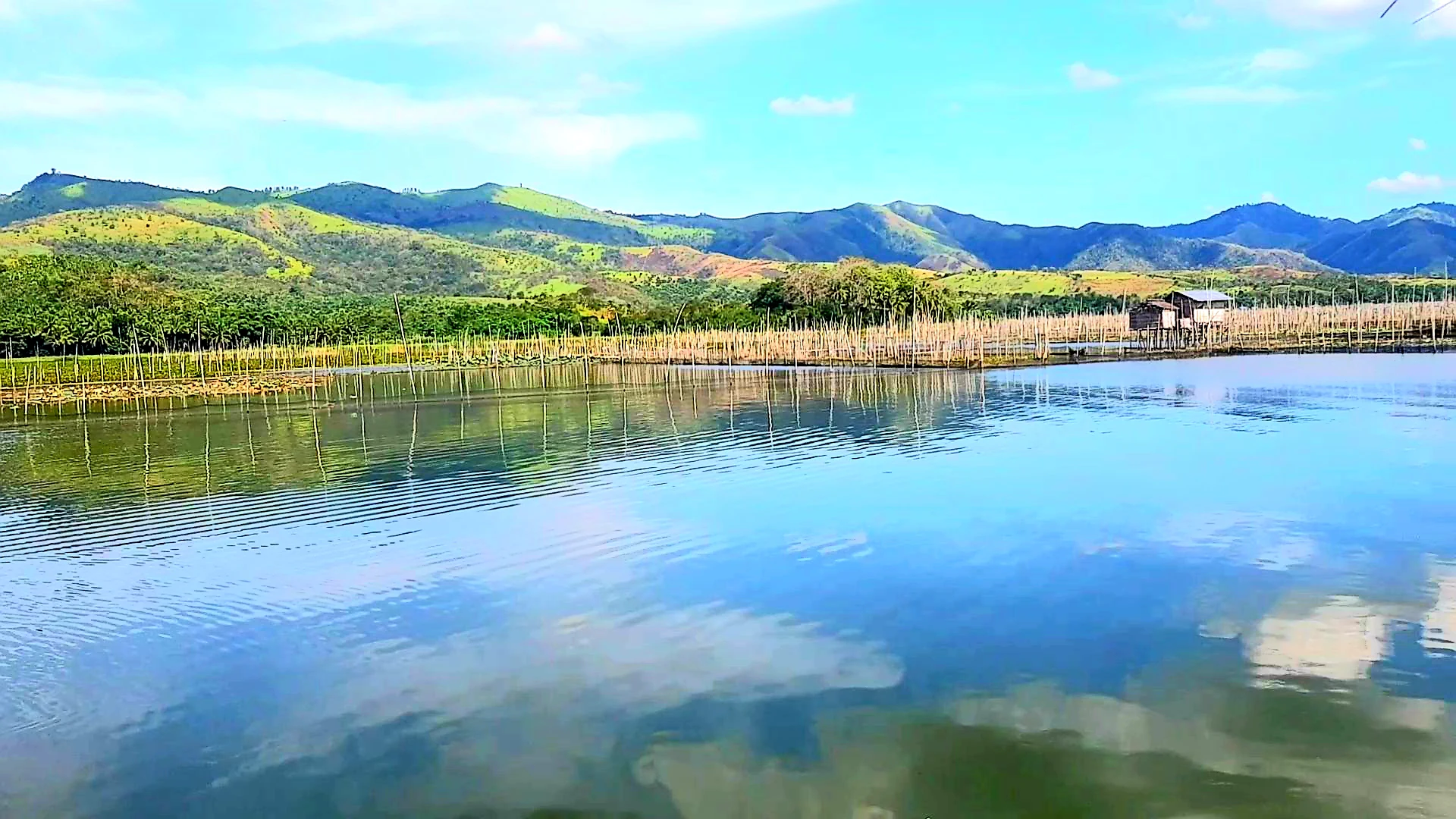
A wide view of Lake Buluan, showing calm blue water reflecting the sky, with wooden poles used for fishing in the water and a range of green, rolling mountains in the background.
A view across the waters of Lake Buluan with mountains in the background and traditional fishing structures visible.

Lake Buluan history and protected-area timeline

Lake Buluan's history is closely tied to the surrounding political landscape of southern Mindanao. Before the American colonial era, the lake and its surroundings were formally part of the Sultanate of Buayan, a Maguindanao polity centered on the Buluan area, which shaped the social and cultural organization of the communities along the lake's shores.

This pre-colonial political inheritance gives the lake a longer historical depth than a purely natural resource baseline. It situates Lake Buluan within an indigenous Maguindanao tradition of settlement and governance along the lake and its adjacent marshy river basins, a framework that endured through transitions in political administration up to the modern provincial structure that now divides the lake between Maguindanao del Sur and Sultan Kudarat.

Lake Buluan landscape and geographic character

Lake Buluan sits in a low-lying section of interior Mindanao, with an average elevation of around 4.5 meters above mean sea level. Rather than being defined by dramatic relief, the lake's landscape is shaped by shallowness and the gentle margins of surrounding marshy basins. With an average depth of about 4.5 meters and a maximum depth near 6 meters, the lake reads more as an expansive flooded plain than a deep lake.

The surrounding terrain is essentially a network of adjoining lowland river basins that converge on the lake. The Pulangi, Maanoy, Buluan, and Alah rivers, all tributaries of the Mindanao River, feed into Lake Buluan from different directions, while the Marbel River is identified as a primary inflow. The result is a soft, water-dominated landscape of shallow open water, fringing marshes, and seasonally flooded fringes that blend gradually into the surrounding lowlands of Maguindanao del Sur and Sultan Kudarat.

Lake Buluan ecosystems, habitats, and plant life

The ecological character of Lake Buluan is shaped primarily by its function as a shallow, river-fed inland freshwater system. Because the lake is essentially a composite of adjoining marshy basins fed by several tributaries, its nature is less that of a single open-water lake and more that of a lowland wetland complex, with open water areas interspersed with marshy shallows, river mouths, and seasonally flooded margins.

This mosaic supports an aquatic ecosystem adapted to warm, shallow, often turbid freshwater conditions. The lake functions as a regional fishery resource, sustaining both native and introduced fish populations that are tied to the lake's productivity and the surrounding communities' livelihoods. The wetland character also implies a broader habitat value, providing transitional environments between open water and terrestrial systems that typically support diverse aquatic and semi-aquatic life.

Lake Buluan wildlife and species highlights

Lake Buluan supports a freshwater fish community typical of lowland Mindanao river-fed lakes. Recorded species include climbing gourami (Anabas testudineus), snakehead murrel (Channa striata), milkfish (Chanos chanos), walking catfish (Clarias batrachus), common carp (Cyprinus carpio carpio), sundari bele (Glossogobius giuris), Mozambique tilapia (Oreochromis mossambicus), spotted or common barb (Puntius binotatus), and snakeskin gourami (Trichopodus pectoralis).

The presence of both indigenous Southeast Asian freshwater species and introduced or widely distributed species like common carp and Mozambique tilapia reflects the lake's mix of natural fish fauna and species with broader regional distributions. The fish community underscores the lake's role as a working inland fishery whose productivity depends on the continued health of its shallow, river-fed aquatic habitat.

Lake Buluan conservation status and protection priorities

Lake Buluan's conservation profile centers on the pressures placed on its habitat by activities beyond its immediate shoreline. Mining operations in the nearby provinces of South Cotabato, Davao del Sur, and Sultan Kudarat have been identified as a threat to the lake's water quality and ecosystem, raising concerns that runoff, sedimentation, or pollution from upstream industrial activity could degrade the conditions that sustain the lake's fisheries and surrounding wetlands.

Because the lake gathers water from multiple river tributaries before flowing onward into the Mindanao River system, the implications of upstream impacts are potentially amplified within Lake Buluan. This makes the lake not just a local fishery resource but also a downstream indicator whose condition reflects the broader management of Mindanao's interior catchment.

Lake Buluan cultural meaning and human context

The cultural context of Lake Buluan is rooted in the Maguindanao presence that has historically organized life around the lake. Before the American era, the lake and its surroundings were within the Sultanate of Buayan, an important Maguindanao polity that anchored political, social, and cultural life in the Buluan area and along the lake's fringes.

That legacy continues to shape the identity of the lake's surrounding communities across the present-day provinces of Maguindanao del Sur and Sultan Kudarat, where fishing, riverine livelihoods, and longstanding settlement patterns around the lake reflect centuries of adaptation to the wetland landscape and its waters.

Top sights and standout views in Lake Buluan

Lake Buluan combines the profile of Mindanao's third largest lake with the environmental character of a wide, shallow, river-converging freshwater system. The lake's key strengths are its scale within Mindanao, its wetland-rich mosaic of marshy basins fed by the Pulangi, Maanoy, Buluan, and Alah rivers, and its cross-province role between Maguindanao del Sur and Sultan Kudarat. Also of note is the lake's historical grounding in the pre-American Sultanate of Buayan and its present-day importance as both a regional fishery and a focal point for discussions of water quality and upstream pollution in southern Mindanao's interior.

Best time to visit Lake Buluan

Lake Buluan's shallow marshy character means it retains water year-round, but visitors interested in clearer open-water conditions and actively used landing areas often find the dry season a more comfortable period for getting close to the lake and its surrounding communities. During the rainy season, the lake's already marshy margins widen further as the tributary rivers swell with flow, deepening the wetland feel of the basin but also potentially making access more difficult. Visitors drawn to the lake's landscape character and cultural context generally benefit from approaching it as a regional destination tied to its surrounding Maguindanao del Sur and Sultan Kudarat communities rather than a compact single-site attraction.
Monthly climate preview

Long-term monthly temperature averages and precipitation patterns for Maguindanao del Sur

Lake Buluan Climate Normals, Annual Temperature and Precipitation Rhythm

Representative coordinates record sustained monthly temperature ranges between 24.69 °C and 26.4 °C alongside varying daily precipitation rates from 2.82 mm to 6.63 mm. Examining the complete twelve-month climatology profile provides deeper analytical insight into annual meteorological cycles across the terrain.
Annual mean25 °C
25 °C26 °C
Jan25°
Feb25°
Mar26°
Apr26°
May26°
Jun25°
Jul25°
Aug25°
Sep25°
Oct25°
Nov25°
Dec25°
Warmest month
April

26.4 °C

Coolest month
January

24.7 °C

Wettest month
June

6.6 mm/day

Driest month
February

2.8 mm/day

Park location guide

Geography guide, regional context, and park location map for Lake Buluan

Lake Buluan park geography, regions, and map view in Philippines

Understand where Lake Buluan sits in Philippines through a broader geographic reading of the surrounding landscape, nearby location context, and its mapped position within the national park landscape.

How Lake Buluan fits into Philippines

The Philippines, officially the Republic of the Philippines, is an archipelagic nation in Southeast Asia comprising approximately 7,641 islands categorized into three main geographical divisions: Luzon, Visayas, and Mindanao. Located in the western Pacific Ocean, it shares maritime borders with Taiwan, Japan, Palau, Indonesia, Malaysia, Vietnam, and China. Manila serves as the capital city, while Quezon City is the most populated city, both within Metro Manila.

Wider geography shaping Lake Buluan in Philippines

The Philippines is an archipelagic nation in Southeast Asia, positioned in the western Pacific Ocean. Its islands are bounded by the South China Sea to the west, Philippine Sea to the east, and Celebes Sea to the south. The country shares maritime borders with Taiwan to the north, Japan to the northeast, Palau to the east and southeast, Indonesia to the south, Malaysia to the southwest, Vietnam to the west, and China to the northwest.

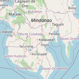
Map view of Lake Buluan

Use this park location map to pinpoint Lake Buluan in Philippines, understand its exact geographic position, and read its mapped placement within the surrounding landscape more clearly.

Pigeon | © OpenStreetMap contributors

Location context for Lake Buluan

Maguindanao del SurSultan Kudarat

Explore photographic records of shallow marsh basins, river confluences, and lowland terrain.

Lake Buluan Photos and Landscape Scenery: Visualizing Mindanao Wetland Habitats

Visual documentation captures the expansive open water, fringing marshes, and river-fed floodplains that define the lowland geography of Lake Buluan. Photographic records provide clear visual context for the shallow basin terrain, wetland habitats, and regional hydrological networks spanning southern Mindanao.

A wide view of Lake Buluan, showing calm blue water reflecting the sky, with wooden poles used for fishing in the water and a range of green, rolling mountains in the background.

Park atlas

Compare adjacent lowland basins, river-fed waters, and regional conservation areas

Exploring Parks Near Lake Buluan and Surrounding Protected Wetland Landscapes

Continue geographic discovery by comparing Lake Buluan with other protected wetland basins and river-fed lowland ecosystems across the surrounding region. Analyzing adjacent conservation areas helps place interior Mindanao freshwater habitats into a broader geographical and ecological perspective.
A watercolor illustration of a mountain range with green, yellow, and soft pink hues, featuring rolling hills and forested slopes in a panoramic format.
National parkPhilippines
About 48 km away#1 closest

Northeast

Mount Apo Natural Park: Volcanic Terrain and Biodiversity in Mindanao, Philippines

Mapping the highest peak and endemic-rich montane ecosystems

Spanning the provinces of Davao del Sur and Cotabato, Mount Apo Natural Park protects the volcanic massif of Mount Apo and its extensive forest surroundings. The park exhibits a distinct altitudinal zonation that supports a significant concentration of endemic birds, mammals, and plant life. Beyond its ecological relevance, the area features dramatic volcanic ridges, cascading waterfalls, and the high-elevation Lake Venado, forming a vital component of the regional natural heritage network in the southern Philippines.

Area
640.53 km²
Established
2004
Relief
Mountain
Climate
Tropical
A watercolor painting showing a soft, peaceful scene with green rolling hills, a calm bay or river in the foreground, and a pale pink and yellow sky.
National parkSarangani
About 84 km away#2 closest

Southeast

Sarangani Bay National Park: Regional Geography and Protected Seascape Atlas

Coastal landscapes and maritime boundaries in southern Mindanao

Sarangani Bay represents a unique intersection of heavy maritime commerce and formal protected-area status. Stretching across the southern coastline of Mindanao, the bay provides a vital anchor for regional geography and ecological oversight. Examine the mapped extent, coastal municipalities, and the integration of this expansive marine environment into the national protected-area system.

Established
2018
Relief
Lowland
Scope
Marine
Water
Water-dominated
National parkMaguindanao del Norte
About 87 km away#3 closest

Northwest

Mado Hot Spring National Park: Protected Geothermal Landscape in Maguindanao del Norte

Explore its therapeutic hot springs and mapped boundaries

Mado Hot Spring National Park, located in Maguindanao del Norte, Philippines, is a protected area defined by its geothermal features and therapeutic hot springs. This national park, established early in the Philippines' conservation history, offers a unique landscape centered around a warm mineral-rich natural pool. Delve into the geographic context and protected area identity of this distinctive site, understanding its role within the region's natural heritage.

Area
0.48 km²
Established
1939
IUCN
II
Scope
Terrestrial
National parkLanao del Sur
About 147 km away#4 closest

North

Salikata National Park: Explore Philippines National Park Geography

Mapped protected area boundaries and regional context.

Investigate Salikata National Park, a key protected area designated as a national park within Lanao del Sur, Philippines. This detailed view provides essential context for understanding its mapped boundaries, its place in the regional geography, and its significance as a protected landscape. Discover the unique geographic attributes that define Salikata National Park for atlas-based exploration.

Established
1965
IUCN
V
Relief
Mountain
Climate
Tropical
National parkLanao del Sur
About 149 km away#5 closest

North

Rungkunan National Park: Mapped Protected Landscape and Regional Geography Overview

Discover Rungkunan National Park's protected boundaries and landscape context.

Gain insight into Rungkunan National Park, a protected national park situated in Lanao del Sur. This page details the park's geographic positioning, mapped outlines, and its significance as a conservation landscape. It provides essential context for understanding the distribution of protected areas and the regional geography of the Philippines, facilitating a deeper atlas-style exploration.

Established
1965
IUCN
V
Water
Minor water
National parkLanao del Sur
About 153 km away#6 closest

North

Lake Butig National Park: National Park Atlas and Geographic Discovery in Lanao del Sur

Discover its mapped boundaries and regional landscape context.

Lake Butig National Park is a protected national park in the Philippines, located within Lanao del Sur. This entry provides specific geographic information and supports atlas exploration by detailing the park's mapped boundaries and its place within the regional landscape. Understand the terrain and protected area context crucial for geographic study and understanding Philippine natural landscapes.

Area
0.68 km²
Established
1965
IUCN
V
Relief
Mountain
National parkLanao del Sur
About 153 km away#7 closest

North

Pantuwaraya Lake National Park: National Park Atlas and Mapped Landscape

Explore the protected area and regional geography of Lanao del Sur.

Understand Pantuwaraya Lake National Park as a defined protected landscape and a significant national park within the Philippines. This entry focuses on its geographic placement in Lanao del Sur, providing context for its mapped boundaries and natural features. Users can explore its representation within a broader atlas of protected lands, gaining insight into its role and landscape identity.

Area
0.2 km²
Established
1965
IUCN
V
Climate
Tropical
Marine protected areaDavao Oriental
About 159 km away#8 closest

East

Pujada Bay Protected Seascape: Marine Protected Area and Coastal Landscape in Davao Oriental

Coastal geography and protected marine ecosystems of Mindanao

Pujada Bay Protected Seascape serves as a primary coastal sanctuary along the Davao Oriental shoreline. Defined by the convergence of mountain-fed rivers, mangrove forests, and coral reef habitats within a semi-enclosed bay, this protected area offers a deep look into the marine geography of the Philippine archipelago.

Area
212 km²
Established
1994
Relief
Mixed relief
Access
Access unknown

Common questions about visiting, size, designation, and location context for Lake Buluan

Lake Buluan FAQs for park facts, access, geography, and protected area context

Find quick answers about Lake Buluan, including protected-area facts, park geography, trail and visitor context, and how the park fits into its surrounding country and regional landscape.
MoriAtlas Explorer

Continue Your Protected Areas Search Across the Global Atlas

Deepen your exploration by continuing the structured search for national parks and protected areas worldwide. Utilize the comprehensive filtering capabilities to compare different conservation landscapes and refine your understanding of global park geography. Discover more about the distribution and characteristics of protected natural areas.

Global natural geography