Mori Atlas logo
Marine protected areaLake Ontario National Marine Sanctuary

Exploring the maritime archaeology, underwater cultural heritage, and Indigenous landscape significance of this New York sanctuary.

Lake Ontario National Marine Sanctuary: Mapped Boundaries and Freshwater Protected Landscapes

The Lake Ontario National Marine Sanctuary encompasses over 1,700 square miles of cold, fresh water along the New York coastline, serving as a primary site for protected maritime history. This area preserves a dense concentration of well-preserved shipwrecks alongside an enduring spiritual landscape for the Haudenosaunee Confederacy. Beyond the underwater sites, the sanctuary connects with a diverse regional shoreline featuring harbors, lighthouse stations, and deep-water basins that define the freshwater terrain of the Great Lakes.

national marine sanctuaryGreat LakesLake Ontariofreshwater sanctuaryshipwrecksunderwater archaeology

Lake Ontario National Marine Sanctuary

Marine protected area

Park overview

Structured park overview, official facts, and landscape profile for Lake Ontario National Marine Sanctuary

Lake Ontario National Marine Sanctuary park facts, protected area profile, and essential visitor context

Review the core facts for Lake Ontario National Marine Sanctuary, including designation, size, terrain, visitor scale, habitats, and operating context in one park-focused overview.

About Lake Ontario National Marine Sanctuary

The Lake Ontario National Marine Sanctuary is a federally protected freshwater seascape in southeastern Lake Ontario, established to safeguard a remarkable mix of maritime heritage and Indigenous cultural history. Encompassing about 1,722 square miles along the New York shoreline from Jefferson and Oswego counties to Wayne County, the sanctuary extends to the international border with Canada and includes a substantial portion of one of North America's largest freshwater lakes.

What sets this sanctuary apart from other protected areas in the United States is its underwater focus within a freshwater lake rather than an ocean or coastal marine environment. The cold, oxygen-rich, low-salinity conditions of Lake Ontario have preserved shipwrecks with unusual fidelity. Divers, maritime archaeologists, and historians have documented dozens of wrecked vessels within the sanctuary, ranging from late 18th-century sailing craft to 19th-century schooners and a World War II-era aircraft. These wrecks tell layered stories of commerce, immigration, naval history, shipbuilding, and the everyday life of communities that depended on the lake.

The sanctuary also acknowledges that Lake Ontario was, and remains, a living cultural landscape. The Onondaga, Cayuga, Seneca, Oneida, and later Tuscarora peoples of the Haudenosaunee Confederacy have used these waters for trade, travel, fishing, and ceremony since long before European contact. NOAA has formally recognized that the sanctuary's waters hold cultural, historical, and spiritual value for these nations, and archaeological sites within the sanctuary may contain Indigenous artifacts and other sensitive heritage materials.

In addition to protection, the sanctuary offers research, education, community engagement, and heritage tourism opportunities. Scuba diving, recreational boating, fishing, paddling, lighthouse visits, and maritime museums all connect visitors to the broader story of southeastern Lake Ontario, while NOAA continues to support hydrographic survey work, habitat mapping, and the ongoing identification of submerged cultural resources throughout the area.

Quick facts and research context for Lake Ontario National Marine Sanctuary

The sanctuary lies off the New York State shoreline in Jefferson, Oswego, Cayuga, and Wayne counties and extends northward to the international border with Canada. It is administered by NOAA's Office of National Marine Sanctuaries in partnership with the State of New York.

Designated on September 6, 2024, it is the 16th National Marine Sanctuary in the United States and the first located in New York waters. Its protection focuses on submerged cultural resources, particularly shipwrecks, aircraft wreckage, and related underwater archaeological sites connected to more than two centuries of maritime activity on Lake Ontario.

Protection and recognition

Explore documented marine conservation scope, 2024 establishment timeline, and recognized protected area data.

Lake Ontario National Marine Sanctuary Protection Status and Designation History

Lake Ontario National Marine Sanctuary maintains an established marine protection status backed by official designation records from 2024. Review structured management scope details alongside verified conservation frameworks for this protected water landscape.

Protection details

Protection scope
Marine
Designated year
2024
Transboundary protection
No
Park context

Deeper park guide and search-rich context for Lake Ontario National Marine Sanctuary

Lake Ontario National Marine Sanctuary history, landscape, wildlife, and travel context

Explore Lake Ontario National Marine Sanctuary through its history, landscape character, ecosystems, wildlife, conservation priorities, cultural context, and seasonal travel timing in a structured park guide built for atlas discovery and search intent.

Why Lake Ontario National Marine Sanctuary stands out

The Lake Ontario National Marine Sanctuary is best known for its exceptional collection of historic shipwrecks preserved in cold, fresh water, some of which are among the oldest and best-preserved wrecks in the Great Lakes. Notable sites include the schooner St. Peter, listed on the National Register of Historic Places, and the sloop Washington, the oldest known commercial sailing vessel on the lake. Equally defining is the sanctuary's recognition of southeastern Lake Ontario as an enduring cultural and spiritual landscape for the Haudenosaunee Confederacy, whose member nations see the lake as central to identity, history, and traditional lifeways. The combination of maritime archaeology and Indigenous heritage, set within a freshwater lake environment, gives the sanctuary a distinctive identity within the National Marine Sanctuary system.

An underwater photograph looking down at the wooden deck of a shipwreck in Lake Ontario, featuring a central metal bollard covered in small crustaceans.
An underwater view of the deck and a mooring bollard on the St. Peter shipwreck in Lake Ontario.

Lake Ontario National Marine Sanctuary history and protected-area timeline

The idea for a National Marine Sanctuary on Lake Ontario took shape in early 2017, when leaders from Jefferson, Oswego, Cayuga, and Wayne counties in New York, along with the city of Oswego, jointly submitted a nomination to NOAA. The proposal described a roughly 1,746-square-mile area of southeastern Lake Ontario that already encompassed more than twenty known shipwrecks and one aircraft wreck, with dozens of additional sites suspected. Endorsements came from the Governor of New York, the Onondaga Nation, and a wide range of historical, educational, conservation, and tourism organizations.

NOAA signaled its intent to pursue the designation in April 2019 and, in 2020, convened a 15-member pre-designation Sanctuary Advisory Council representing diverse community stakeholders. The council became an important liaison between NOAA and local communities throughout the multi-year process. By July 2021, NOAA had published a draft environmental impact statement and draft management plan laying out possible boundary configurations and levels of protection.

Public engagement was a defining feature of the process. NOAA held public meetings in communities such as Fair Haven, New York, and received dozens of written comments, the great majority supportive of the sanctuary. Concerns from the commercial shipping sector and several federal agencies ultimately led NOAA to limit the proposed boundary to Lake Ontario and exclude the St. Lawrence River. In October 2022, the NOAA survey ship NOAAS Thomas Jefferson conducted a hydrographic survey over 274 square nautical miles of the proposed area, including the deepest point of Lake Ontario, searching particularly for the wreck of the sloop Washington.

Following a proposed rulemaking in January 2023, a further round of public comments, and consultations with Indigenous nations, NOAA finalized the environmental impact statement in April 2024 and announced the upcoming designation in June 2024. After the required 45-day congressional review period, the Lake Ontario National Marine Sanctuary was officially designated on September 6, 2024, becoming the 16th National Marine Sanctuary in the United States, the third in the Great Lakes, and the first in New York State waters. New community-based governance was established concurrently through a new Sanctuary Advisory Council.

Lake Ontario National Marine Sanctuary landscape and geographic character

The physical setting of the Lake Ontario National Marine Sanctuary is defined by the vast southwestern shoreline of Lake Ontario, the smallest by surface area of the five Great Lakes yet one of the deepest. The sanctuary encompasses an extensive offshore region along the New York coast, including waters off Jefferson, Oswego, Cayuga, and Wayne counties, and extends northward toward the international border where Lake Ontario meets the St. Lawrence River.

The lake itself forms a dramatic freshwater interior landscape. Beneath its surface lie broad sedimentary basins, submerged shoals, and the deepest point of the lake, where depths exceed 240 meters. The cold, well-oxygenated fresh water creates exceptional conditions for the preservation of cultural materials and supports distinctive freshwater ecosystems. The shoreline that frames the sanctuary includes working harbors, lighthouse stations such as Tibbetts Point Light and the Oswego Harbor West Pierhead Light, beaches, bluffs, and stretches of New York state park land that connect visitors with the lake.
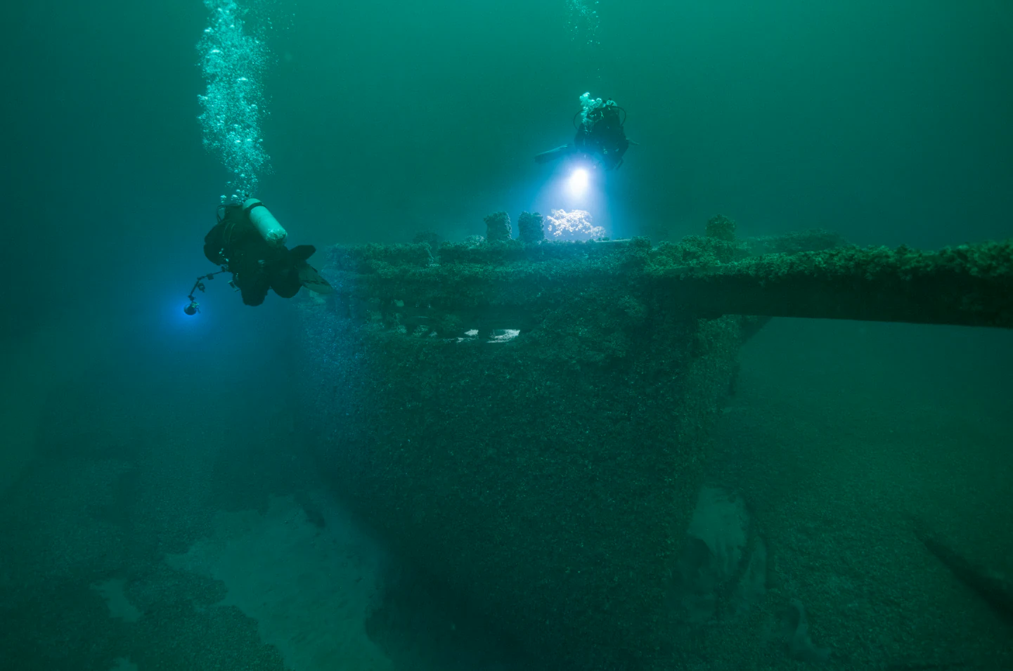
Underwater view of two scuba divers using flashlights to inspect the wooden wreckage of a historic schooner on the lakebed.
Scuba divers exploring the bowsprit and deck of the St. Peter shipwreck in Lake Ontario.

Lake Ontario National Marine Sanctuary ecosystems, habitats, and plant life

Although the Lake Ontario National Marine Sanctuary is recognized primarily for its cultural heritage rather than its ecology, the protected waters also encompass significant freshwater habitat. The cold, oxygen-rich conditions and the lake's depth support fish populations and broader aquatic life that have sustained human communities, from Indigenous peoples to modern recreational anglers, for centuries.

The sanctuary's waters and shoreline are also being studied as habitat space in their own right. Future NOAA survey work, including planned work with uncrewed surface vehicles, is explicitly aimed at identifying critical habitats within the sanctuary. This ecological dimension complements the protected area's cultural mission, recognizing that Lake Ontario is simultaneously an underwater archaeological landscape and a living freshwater ecosystem.
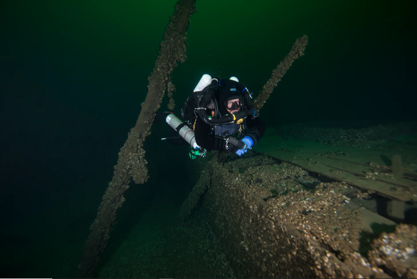
A scuba diver in full gear examines the submerged wooden wreckage of a ship in dark, deep water.
A scuba diver explores the historic shipwreck of the schooner St. Peter in Lake Ontario.

Lake Ontario National Marine Sanctuary wildlife and species highlights

The sanctuary's wildlife story is tightly interwoven with its human heritage. The lake supports fish populations historically central to the diets, economies, and spiritual lives of the Haudenosaunee peoples, and ongoing Indigenous stewardship of these resources remains a defining feature of the area.

For modern visitors, recreational fishing is one of the principal ways people encounter the sanctuary's wildlife. Pleasure boating, paddling, and diving also bring visitors into contact with the lake's broader aquatic environment, while the surrounding shoreline hosts the birds and terrestrial wildlife typical of the Great Lakes coastal zone.

Two scuba divers suspended in deep green water while using a professional underwater camera setup to film a historic shipwreck site.
Divers documenting the St. Peter shipwreck in Lake Ontario National Marine Sanctuary.

Lake Ontario National Marine Sanctuary conservation status and protection priorities

The Lake Ontario National Marine Sanctuary is itself an act of conservation, applying the National Marine Sanctuary framework within an inland freshwater context that is unusual in the U.S. protected areas system. By federal regulation, activities that could harm the sanctuary's archaeological resources are restricted: moving, damaging, possessing, or selling sanctuary resources and anchoring on shipwrecks are prohibited, and permits are required for tethered underwater systems such as remotely operated vehicles.

The sanctuary's conservation rationale emphasizes the preservation of submerged cultural heritage, including the wrecks themselves, the lakebed context that protects them, and the broader landscapes of meaning associated with them. NOAA has also committed to working with the Haudenosaunee Confederacy to protect culturally and spiritually significant sites and sensitive archaeological materials, recognizing that conservation in this setting extends beyond physical artifacts to include living cultural relationships with the lake. The partnership with the State of New York ensures that day-to-day management reflects both federal standards and local priorities.

Lake Ontario National Marine Sanctuary cultural meaning and human context

The cultural fabric of the Lake Ontario National Marine Sanctuary stretches back centuries. Long before European arrival, the ancestors of the Onondaga, Cayuga, Seneca, and Oneida peoples used these waters for transportation and trade in canoes and other small boats. By around 1000 CE, these nations had begun to coalesce into what would become the Haudenosaunee Confederacy, with the Tuscarora joining in 1722. The lake remains central to the identity, language, and ceremonies of these nations, and their stewardship of the water and its fish continues today.

Coupled with this Indigenous heritage is a more recent but equally important maritime story. From the era of European exploration through early American industrialization, Lake Ontario carried ships, cargo, and people that shaped the growth of the northeastern United States. The wrecks within the sanctuary, from the late 18th-century sloop Washington to 19th-century cargo schooners and a World War II transport aircraft, embody that history in tangible form. Lighthouses, harbor piers, maritime museums, and state parks along the shoreline further anchor the lake in regional identity as a working, traveling, and remembering landscape.
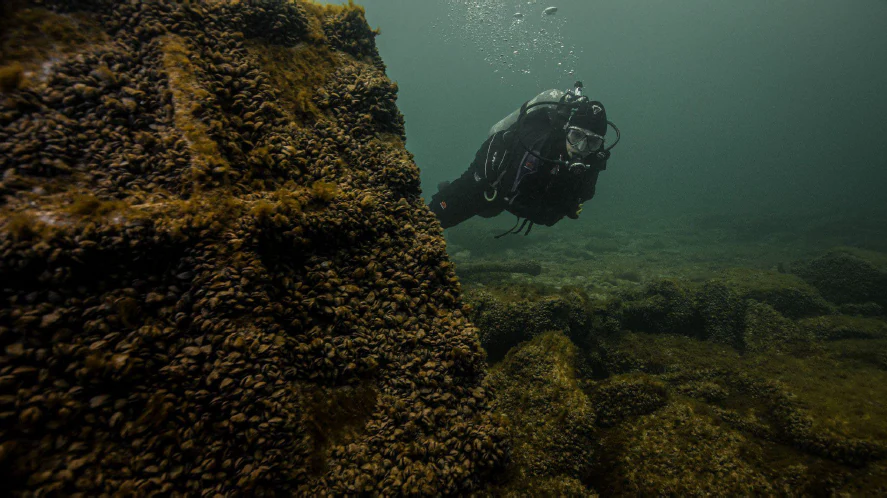
A scuba diver in full gear floating underwater next to the sediment and mussel-covered hull of a shipwreck in Lake Ontario.
A scuba diver explores a historic shipwreck in the Lake Ontario National Marine Sanctuary.

Top sights and standout views in Lake Ontario National Marine Sanctuary

The Lake Ontario National Marine Sanctuary brings together two major strands of heritage in a single protected area: the maritime history of the Great Lakes, expressed through dozens of unusually well-preserved shipwrecks, and the enduring cultural and spiritual relationship of the Haudenosaunee Confederacy with the lake. Few protected areas in the United States combine underwater cultural resource preservation of this density with formal recognition of Indigenous heritage at this scale.

Its status as the first National Marine Sanctuary in New York waters and the third on the Great Lakes underscores its significance within NOAA's national system. For visitors, the sanctuary offers an unusual blend of freshwater scuba diving, lighthouse and maritime-museum touring, paddling, recreational fishing, and shoreline exploration, all set within one of the most historically rich sections of Lake Ontario.
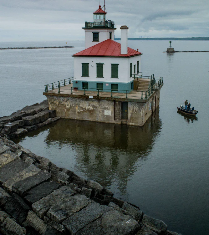
A white square lighthouse with a red roof and green trim, built on a stone-faced concrete pier in calm water, with a small boat nearby and a rocky breakwater in the foreground.
A historic lighthouse situated on a concrete foundation in the waters of Lake Ontario.

Best time to visit Lake Ontario National Marine Sanctuary

Because the Lake Ontario National Marine Sanctuary is primarily a water-based protected area rather than a terrestrial park with dramatic seasonal scenery shifts, visitation considerations turn on lake conditions rather than foliage or wildlife migrations. Summer is generally the most practical season for scuba diving, boating, paddling, and visiting shoreline lighthouses and maritime museums, when water temperatures are more comfortable and surface conditions are calmer for recreational activity.

Shoulder seasons can offer quieter experiences for those interested in shoreline heritage sites and museum visits, though colder water can affect diving and paddling opportunities. Visitors interested in active NOAA research or survey operations will want to track NOAA announcements, as survey periods, including future work by ships like NOAAS Thomas Jefferson, occasionally provide windows to observe the sanctuary in action.

Monthly climate preview

Long-term representative temperature and precipitation rhythm across twelve recorded intervals

Lake Ontario National Marine Sanctuary Climate Normals and Annual Weather Patterns

Lake Ontario National Marine Sanctuary displays a recorded monthly temperature range from sub-zero winter minimums to warm summer maximums alongside steady precipitation averages. Reviewing the complete twelve-month climatological profile provides deeper insight into measured long-term environmental patterns at this protected location.
Annual mean9 °C
-2 °C21 °C
Jan-2°
Feb-2°
Mar
Apr
May10°
Jun16°
Jul21°
Aug21°
Sep18°
Oct12°
Nov
Dec
Warmest month
August

21.1 °C

Coolest month
February

-2.4 °C

Wettest month
October

3.1 mm/day

Driest month
February

2 mm/day

Park location guide

Geography guide, regional context, and park location map for Lake Ontario National Marine Sanctuary

Lake Ontario National Marine Sanctuary park geography, regions, and map view in United States of America

Understand where Lake Ontario National Marine Sanctuary sits in United States of America through a broader geographic reading of the surrounding landscape, nearby location context, and its mapped position within the national park landscape.

How Lake Ontario National Marine Sanctuary fits into United States of America

The United States of America is a federal presidential republic and one of the world's largest countries by area and population. It consists of 50 states across a vast territory spanning multiple time zones, with its capital in Washington, D.C. and largest city in New York City. The nation has a diverse economy, influential political system, and significant cultural and military presence globally.

Wider geography shaping Lake Ontario National Marine Sanctuary in United States of America

The United States occupies a vast territory in North America, bordered by Canada to the north and Mexico to the south. The 48 contiguous states stretch from the Atlantic to the Pacific Ocean, while Alaska occupies the northwestern region and Hawaii is an archipelago in the Pacific. The country encompasses diverse terrain including the Rocky Mountains, Appalachian Mountains, Great Plains, and extensive river systems.

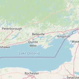
Map view of Lake Ontario National Marine Sanctuary

Use this park location map to pinpoint Lake Ontario National Marine Sanctuary in United States of America, understand its exact geographic position, and read its mapped placement within the surrounding landscape more clearly.

Pigeon | © OpenStreetMap contributors

Location context for Lake Ontario National Marine Sanctuary

New York

Visualizing freshwater environments, maritime heritage, and protected coastal geography

Lake Ontario National Marine Sanctuary Photos and Landscape Scenery

Visual documentation of Lake Ontario National Marine Sanctuary reveals the expansive freshwater environments, submerged archaeological sites, and rugged New York coastlines that define the protected area. Examining these detailed photographic records helps researchers and visitors understand the distinctive aquatic terrain and conservation character of the Great Lakes.

An underwater photograph looking down at the wooden deck of a shipwreck in Lake Ontario, featuring a central metal bollard covered in small crustaceans.

Two scuba divers in full gear exploring the wooden hull of a historic shipwreck underwater, illuminated by their dive lights.

Underwater view of two scuba divers using flashlights to inspect the wooden wreckage of a historic schooner on the lakebed.

A scuba diver in full gear examines the submerged wooden wreckage of a ship in dark, deep water.

Two scuba divers suspended in deep green water while using a professional underwater camera setup to film a historic shipwreck site.

Underwater view of two scuba divers using flashlights to explore the wooden remains of a sunken shipwreck on the lake bed.

A scuba diver in full gear floating underwater next to the sediment and mussel-covered hull of a shipwreck in Lake Ontario.

A white square lighthouse with a red roof and green trim, built on a stone-faced concrete pier in calm water, with a small boat nearby and a rocky breakwater in the foreground.

Two scuba divers swimming near the prominent bowsprit and hull of an underwater shipwreck, rendered in high-contrast black and white.

An underwater view of a scuba diver in dark gear using a flashlight to explore the wooden wreckage of a submerged ship.

Park atlas

Compare adjacent freshwater landscapes and connected maritime conservation areas across New York.

Exploring Parks Near Lake Ontario National Marine Sanctuary and Regional Protected Areas

Visitors reviewing Lake Ontario National Marine Sanctuary can continue exploring surrounding freshwater ecosystems and protected coastal terrain. Comparing nearby conservation areas reveals broader patterns in regional geography and Great Lakes heritage.
Watercolor painting of green hills, islands, and a body of water under a pale yellow sky
National parkOntario
About 46 km away#1 closest

Northeast

Thousand Islands National Park: Exploring Ontario's Protected Landscape Geography

Discover the mapped terrain and regional context of this national park.

Uncover the protected landscape identity of Thousand Islands National Park, a key national park located in Ontario. This resource focuses on its geographic setting, mapped boundaries, and overall atlas context, providing a clear understanding of its role as a protected area. Explore how its unique terrain contributes to the regional geography and the broader national park network, offering valuable insight for landscape-focused discovery.

Area
24.4 km²
Established
1904
IUCN
II
Visitors
109.3K annual
Wildlife reserveOntario
About 47 km away#2 closest

North

Prince Edward Point National Wildlife Area: Protected Geography and Migration Hub

Coastal woodland and shoreline terrain in southeastern Ontario

Prince Edward Point National Wildlife Area is a federal reserve located on a narrow peninsula extending into Lake Ontario. This area features a diverse landscape of forest patches, open meadows, and jagged lakefront, providing critical refuge for migrating bird species. As a long-standing center for ornithological research, the site remains an essential node for understanding the regional migration patterns and natural heritage of the Great Lakes basin.

Area
5.6 km²
Established
1980
IUCN
Ia
Relief
Lowland
Wildlife reserveOntario
About 88 km away#3 closest

Northwest

Wellers Bay National Wildlife Area: Coastal and Island Geography in Ontario

An important Great Lakes barrier beach protected reserve

Wellers Bay National Wildlife Area contains a rare collection of undeveloped shorelines, including the Baldhead peninsula and offshore islands. This protected area offers a deep look into the littoral processes of Lake Ontario, providing crucial sanctuary for waterbirds and endangered species within a fragile, compact, and natural woodland environment.

Area
0.74 km²
Established
1978
IUCN
Ia
Scope
Terrestrial
Wildlife reserveOntario
About 169 km away#4 closest

Northeast

Rideau Migratory Bird Sanctuary: Protected Wildlife Reserve and Regional Waterfowl Habitat

Riparian conservation zones along the Rideau River in Ontario

The Rideau Migratory Bird Sanctuary protects a strategically important riparian corridor within Ontario. This federal wildlife reserve provides essential refuge for migratory birds along the Rideau River system, offering a specialized look at the region's diverse wetland margins and floodplain geography.

Area
7.52 km²
Established
1957
Wildlife reserveOntario
About 173 km away#5 closest

North

Zugvogelschutzgebiet Mississippi Lake Protected Landscape and Wildlife Reserve Atlas

Waterfowl habitat and wetland geography in Ontario

Zugvogelschutzgebiet Mississippi Lake serves as a designated wildlife reserve providing essential staging grounds for migratory waterfowl. Located at the river-mouth interface on Mississippi Lake, the area encompasses provincially significant wetlands within Ewan Bay. This protected footprint offers a distinct look at the quiet, low-relief hydrology and marsh ecology characteristic of the broader southern Ontario basin.

Area
2.84 km²
Established
1959
IUCN
IV
Relief
Lowland
National parkOntario
About 195 km away#6 closest

West

Rouge National Urban Park: Ontario's Mapped Protected Landscape Atlas

Explore national park boundaries and regional geography.

Investigate Rouge National Urban Park, a designated national park situated in Ontario, Canada. This page provides detailed atlas-style information focusing on its mapped boundaries, regional geographic context, and its identity as a significant protected natural landscape. Understand the park's role within the broader Canadian atlas for landscape exploration.

Area
79.1 km²
Established
2015
IUCN
V
Relief
Mixed relief
A pale, soft watercolor painting of a rolling landscape with green hills, scattered trees, and a flat foreground.
Protected landscapePennsylvania
About 236 km away#7 closest

Southwest

Allegheny National Forest: Geographic Analysis and Protected Landscape Mapping in Pennsylvania

Rolling plateau topography and expansive hardwood forest conservation zones.

Covering over half a million acres in northwestern Pennsylvania, Allegheny National Forest represents a pivotal protected landscape east of the Mississippi. This overview focuses on the intersection of even-aged timber management, old-growth hemlock stands, and the hydrology of the Allegheny Reservoir. Examine the forest's varied terrain, from ridgelines to riverine islands, through a lens of regional conservation and mapped environmental data.

Area
2,076.75 km²
Established
1923
Relief
Upland
Climate
Temperate
A soft watercolor painting depicting a wide, marshy wetland scene with gentle green hills in the distance and reflections on the water surface.
Wildlife reserveQuebec
About 245 km away#8 closest

Northeast

Réserve nationale de faune du lac-Saint-François: A Protected Wetland Landscape in Quebec

Explore wildlife reserve boundaries, riparian habitats, and St. Lawrence River geography.

This protected area safeguards a diverse freshwater wetland complex along the St. Lawrence River. Covering marshes, cedar stands, and mixed hardwood forests, the reserve provides a critical sanctuary for migratory species. The geography of the site offers a unique look at transition zones between open water and inland plains, serving as a key node for bird conservation in Quebec.

Area
15.21 km²
Established
1978
IUCN
III
Relief
Lowland

Common questions about visiting, size, designation, and location context for Lake Ontario National Marine Sanctuary

Lake Ontario National Marine Sanctuary FAQs for park facts, access, geography, and protected area context

Find quick answers about Lake Ontario National Marine Sanctuary, including protected-area facts, park geography, trail and visitor context, and how the park fits into its surrounding country and regional landscape.
MoriAtlas Explorer

Continue Your Protected Areas Search Across the Global Atlas

Deepen your exploration by continuing the structured search for national parks and protected areas worldwide. Utilize the comprehensive filtering capabilities to compare different conservation landscapes and refine your understanding of global park geography. Discover more about the distribution and characteristics of protected natural areas.

Global natural geography