
Mori Atlas logo
National parkThousand Islands National Park

Explore the geographic context and mapped boundaries of this national park in Ontario.

Thousand Islands National Park: Ontario's Mapped Protected Landscape Identity

Discover Thousand Islands National Park, a significant protected area situated within the province of Ontario. This page offers an atlas-driven exploration of its geographic scope and mapped landscape identity, providing essential context for understanding its protected status and natural terrain. Delve into the mapped boundaries and regional geography that define this national park, offering a factual foundation for geographic discovery and conservation landscape exploration.

Island archipelagoRiver landscapeHistorical siteBiosphere ReserveSouthern OntarioIndigenous heritage
Illustrated landscape featuring a river flowing through islands with dense forests and a waterfall

Thousand Islands National Park

National park

Park overview

Structured park overview, official facts, and landscape profile for Thousand Islands National Park

Thousand Islands National Park park facts, protected area profile, and essential visitor context

Review the core facts for Thousand Islands National Park, including designation, size, terrain, visitor scale, habitats, and operating context in one park-focused overview.

About Thousand Islands National Park

Thousand Islands National Park occupies a distinctive position in Canada’s protected areas network as the oldest national park east of the Rocky Mountains. The park’s island landscape represents the eroded remnants of ancient mountains that once formed a continuous highland corridor connecting the Canadian Shield in Ontario to the Adirondack Mountains in New York. This geological formation, known as the Frontenac Axis, created the conditions for the distinctive island archipelago that characterizes the Thousand Islands region today. The park consists of 21 named islands plus numerous smaller islets scattered across the Saint Lawrence River, with two mainland properties providing visitor access at Mallorytown and along the 1000 Islands Parkway. The region has been inhabited by humans for approximately 10,000 years, following the retreat of the last glacial period, and contains significant archaeological evidence of Indigenous presence including pictographs and artifacts. The park is administered by Parks Canada and provides various visitor amenities including camping facilities, hiking trails, and oTENTik accommodations, though much of the island territory remains accessible only by boat.

Quick facts and research context for Thousand Islands National Park

Thousand Islands National Park spans 24.4 square kilometres across 21 islands and multiple islets in the Saint Lawrence River near Brockville, Ontario. Established in 1904, it holds the distinction of being Canada’s oldest national park east of the Rocky Mountains. The park is managed by Parks Canada and is part of the Frontenac Arch Biosphere Reserve, a UNESCO-recognized area known for exceptional biodiversity. Most islands are accessible only by boat, with the visitor centre located at Mallorytown on the mainland. The park features camping facilities, trails, and oTENTik accommodations.

Protection and recognition

Exploring the structured management scope and designation history of the protected island landscape.

Thousand Islands National Park Protection Status and Designation History

Geographic records outline the protection status and management framework governing Thousand Islands National Park since its official designation. Evaluating mapped conservation boundaries helps explorers trace the regional distribution and designation history of protected freshwater environments.

Protection details

Protection scope
Mixed
Designated year
2013
Transboundary protection
No
Park context

Deeper park guide and search-rich context for Thousand Islands National Park

Thousand Islands National Park history, landscape, wildlife, and travel context

Explore Thousand Islands National Park through its history, landscape character, ecosystems, wildlife, conservation priorities, cultural context, and seasonal travel timing in a structured park guide built for atlas discovery and search intent.

Why Thousand Islands National Park stands out

Thousand Islands National Park is best known for its unique island archipelago landscape carved from ancient mountain remnants, its position within the Frontenac Arch Biosphere Reserve representing Canada’s most biodiverse region, and its historical significance as the first eastern Canadian national park. The park preserves Iroquois archaeological sites including pictographs on shoreline cliffs and artifacts such as a 2500-year-old pot discovered by a diver in 1979. Cedar Island features the preserved Cathcart Tower, a Martello tower from the War of 1812 period. The park also hosts experimental theatre performances on Cedar Island as part of The Kick & Push Festival since 2019.
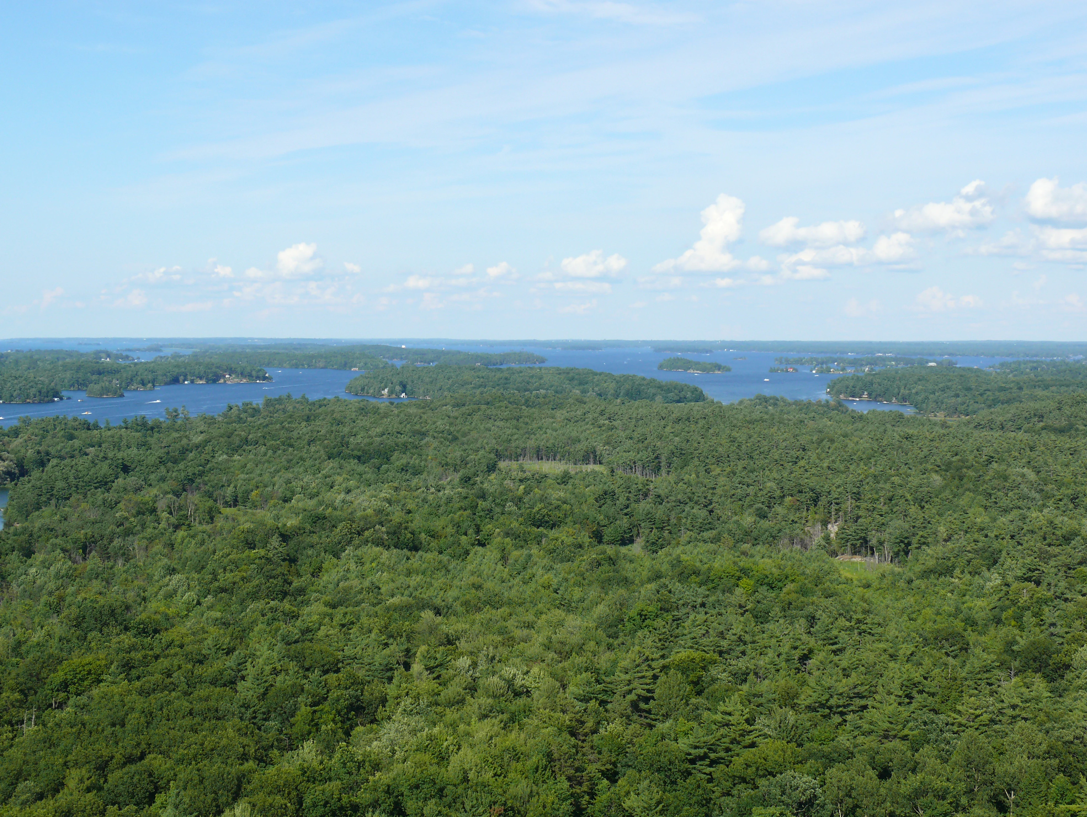
Aerial view of dense green forest with the Saint Lawrence River and distant islands under a partly cloudy sky
Panoramic view of the Saint Lawrence River and Thousand Islands from Hill Island Skydeck

Thousand Islands National Park history and protected-area timeline

The human history of the Thousand Islands region extends back approximately 10,000 years to the hunting and fishing peoples who arrived following the last glacial period. Archaeological evidence within the park includes a 2500-year-old pot discovered by a scuba diver in 1979 and pictographs that remain visible on shoreline cliffs today. By the early 17th century, Iroquois people established large summer encampments along the riverbanks, fishing the productive waters of the Saint Lawrence. French explorers, fur traders, and missionaries began visiting the area around this time, following the river corridor into the interior of the continent. Following the American Revolution at the end of the 18th century, European settlement intensified and gradually displaced the traditional fishing encampments, though some Iroquois continued returning to fish until fish stocks collapsed by the 1860s. During the War of 1812, the area saw significant military activity with both British and American warships present. A British gunboat was sunk nearby and its hull was recovered in 1967; it now resides within the park. Martello towers were constructed in the area for defense, including Cathcart Tower on Cedar Island which remains visible from Kingston. Thousand Islands National Park was established in 1904, originally named St. Lawrence Islands National Park, and was renamed in 2013 to reflect the common name of the natural region. In 1997, the park was identified as having one of the highest levels of ecological impairment among Canadian national parks. Since 2019, the park has partnered with The Kick & Push Festival to host experimental theatre performances on Cedar Island.

Thousand Islands National Park landscape and geographic character

The Thousand Islands landscape consists of a scattered archipelago of islands rising from the Saint Lawrence River, representing the eroded summits of ancient Precambrian mountains. These rocky islands, covered in mixed forest, create a distinctive island-studded waterway that defines the visual character of the region. The Frontenac Axis, the geological corridor that contains these islands, connects the Canadian Shield to the Adirondack Mountains and represents a natural pathway for species movement between these two major geological regions. The islands vary in size and character, with some supporting substantial forest cover while others are bare rock outcrops. The mainland properties along the 1000 Islands Parkway provide accessible trail experiences through forested areas at Mallorytown Landing, Jones Creek, and Landon Bay. The river itself, with its strong currents and seasonal variations, shapes the islands’ shorelines and creates the aquatic environment that distinguishes this park from inland forest reserves.

Thousand Islands National Park ecosystems, habitats, and plant life

The Thousand Islands National Park lies within the Frontenac Arch Biosphere Reserve, which is recognized as the most biodiverse region in Canada due to its position at the confluence of species from multiple continental biomes. The Frontenac Axis serves as a natural corridor allowing northern and southern species to meet and overlap, creating unusual ecological combinations. The islands support diverse forest communities adapted to the rocky island conditions, with mixed deciduous and coniferous forest covering most land areas. The aquatic environment of the Saint Lawrence River adds another dimension to the park’s ecological character, supporting fish species and providing foraging habitat for water birds. The combination of island habitats, mainland forests, and river ecosystems creates a complex ecological mosaic that supports the region’s notable biodiversity.

Thousand Islands National Park wildlife and species highlights

The terrestrial wildlife of Thousand Islands National Park includes typical eastern Ontario species adapted to the mixed forest and rocky island environment. Mammals commonly found in the park include coyotes, white-tailed deer, North American porcupines, North American beavers, foxes, skunks, raccoons, and weasels. Smaller mammals such as rabbits and various squirrel species are also present. The bird population includes turkey vultures, which are frequently seen soaring over the islands, and chickadees and other songbirds in the forest canopy. The park’s location on a major migratory bird route adds seasonal bird diversity, though specific migratory species are not detailed in the source material. The aquatic environment of the Saint Lawrence River supports additional wildlife not catalogued in the available source.

Thousand Islands National Park conservation status and protection priorities

Thousand Islands National Park faces significant conservation challenges, having been identified in 1997 as one of the Canadian national parks with the highest levels of ecological impairment. This recognition reflects the pressures that come with a park located in a densely populated region of southern Ontario, adjacent to major transportation corridors and heavily used waterways. The park’s position within the Frontenac Arch Biosphere Reserve, a UNESCO-recognized biosphere reserve, provides additional conservation framework and recognition for the region’s biodiversity significance. The reserve designation emphasizes sustainable development and conservation partnerships that support the ecological integrity of the broader landscape in which the park sits. Conservation efforts must balance visitor access and recreation with the need to protect the sensitive island ecosystems and archaeological resources.

Thousand Islands National Park cultural meaning and human context

The Thousand Islands region has a rich human history spanning approximately 10,000 years, beginning with hunting and fishing peoples who arrived after the last glacial period. The Iroquois people were significant users of the area in the early 17th century, establishing large summer encampments to exploit the rich fishing grounds of the Saint Lawrence River. French explorers, fur traders, and missionaries followed the river corridor into the continent during this period. Following the American Revolution, European settlement increased and gradually displaced Indigenous fishing practices. The War of 1812 brought military activity to the area, with both British and American warships navigating the islands. The preserved Martello tower on Cedar Island, known as Cathcart Tower, represents this military period and remains a visible historical feature. The park preserves evidence of this long human occupation through archaeological artifacts and pictographs on shoreline cliffs.

Top sights and standout views in Thousand Islands National Park

The Frontenac Arch island archipelago, representing ancient mountain peaks rising from the Saint Lawrence River, forms the park’s most distinctive visual feature. The Cathcart Tower Martello tower on Cedar Island provides a visible connection to the region’s military history during the War of 1812. The park contains significant Indigenous archaeological sites including pictographs on cliff faces and a 2500-year-old pot discovered by a diver in 1979. The Frontenac Arch Biosphere Reserve designation highlights the region’s exceptional biodiversity as Canada’s most biodiverse area. The experimental theatre program on Cedar Island, part of The Kick & Push Festival since 2019, represents a unique cultural use of the park space. Most of the park’s islands are accessible only by boat, preserving a sense of remoteness despite the park’s location in southern Ontario.

Best time to visit Thousand Islands National Park

The summer months offer the most accessible park experience, when boat access to the islands is easiest and the full range of camping and trail facilities are available. The warm season allows visitors to fully experience the island archipelago by boat and enjoy the hiking trails on both the islands and mainland properties. Fall provides a different character as the deciduous forests display autumn coloration across the islands, though boat access becomes more challenging as conditions change. Winter access is limited, though the snow-covered islands and frozen river channels create a distinctly different landscape for those interested in off-season exploration. The shoulder seasons of spring and fall may offer fewer crowds while providing opportunities to experience the park’s changing character and wildlife activity patterns.

Monthly climate preview

Historical temperature normals and precipitation records across the upper Saint Lawrence river landscape.

Thousand Islands National Park Average Temperature and Weather by Month

Long term climate measurements at Thousand Islands National Park reveal a distinct seasonal cycle where average temperatures peak in July and drop lowest in January. Examining the complete monthly database helps researchers trace precipitation trends and temperature extremes recorded at the representative Ontario island landscape.
Annual mean7 °C
-8 °C21 °C
Jan-8°
Feb-7°
Mar-1°
Apr
May13°
Jun18°
Jul21°
Aug21°
Sep17°
Oct
Nov
Dec-4°
Warmest month
July

21.3 °C

Coolest month
January

-7.8 °C

Wettest month
June

2.5 mm/day

Driest month
February

1.5 mm/day

Park location guide

Geography guide, regional context, and park location map for Thousand Islands National Park

Thousand Islands National Park park geography, regions, and map view in Canada

Understand where Thousand Islands National Park sits in Canada through a broader geographic reading of the surrounding landscape, nearby location context, and its mapped position within the national park landscape.

How Thousand Islands National Park fits into Canada

Canada is a federal parliamentary constitutional monarchy spanning North America from the Atlantic to the Pacific and Arctic Oceans. With a population of over 41 million, it is officially bilingual in English and French at the federal level. The country gained independence from the United Kingdom through a gradual process culminating in 1982.

Wider geography shaping Thousand Islands National Park in Canada

Canada occupies the northern portion of North America, sharing its longest international border with the United States. The country extends from the Atlantic Ocean to the Pacific Ocean and northward into the Arctic Ocean, giving it the longest coastline of any nation.

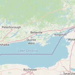
Map view of Thousand Islands National Park

Use this park location map to pinpoint Thousand Islands National Park in Canada, understand its exact geographic position, and read its mapped placement within the surrounding landscape more clearly.

Pigeon | © OpenStreetMap contributors

Location context for Thousand Islands National Park

OntarioUnited Counties of Leeds and Grenville
Recorded earthquake history

Explore the Historical Earthquake Catalogue for Thousand Islands National Park

Review documented seismic events near the park region through a structured historical archive. This collection provided by MoriAtlas allows for the examination of past earthquake records, including magnitude and epicentre data, specifically localized to the Thousand Islands National Park landscape.

Thousand Islands National Park Earthquake History

Catalogued events

2 events

Strongest magnitude

Magnitude 3.6

Most recent event

Jun 29, 2024

This history includes earthquakes recorded inside the park or within 50 km of its borders

A visual atlas showcasing the park's unique island formations, forested shores, and protected riverine habitats.

Thousand Islands National Park: Explore its Iconic Island Archipelago Landscapes and Protected River Scenery

Explore a comprehensive visual collection of Thousand Islands National Park, revealing its distinctive island archipelago, ancient geological formations, and diverse riverine habitats. These protected area photos offer crucial insights into the park's unique landscape character, showcasing its intricate network of forested islands, rocky outcrops, and the dynamic Saint Lawrence River environment.

Aerial view of dense green forest with the Saint Lawrence River and distant islands under a partly cloudy sky

Park atlas

Browse comparable protected landscapes across the Saint Lawrence River and Frontenac Arch region

Discover More National Parks and Protected Areas Near Thousand Islands National Park

Explore other national parks and protected areas geographically connected to Thousand Islands National Park within the diverse Saint Lawrence River and Frontenac Arch region. Compare mapped landscapes, conservation efforts, and regional contexts to deepen your understanding of the unique island archipelago.
Wildlife reserveOntario
About 18 km away#1 closest

Southwest

Prince Edward Point National Wildlife Area: Protected Geography and Migration Hub

Coastal woodland and shoreline terrain in southeastern Ontario

Prince Edward Point National Wildlife Area is a federal reserve located on a narrow peninsula extending into Lake Ontario. This area features a diverse landscape of forest patches, open meadows, and jagged lakefront, providing critical refuge for migrating bird species. As a long-standing center for ornithological research, the site remains an essential node for understanding the regional migration patterns and natural heritage of the Great Lakes basin.

Area
5.6 km²
Established
1980
IUCN
Ia
Relief
Lowland
Wildlife reserveOntario
About 40 km away#2 closest

North

Rideau Migratory Bird Sanctuary: Protected Wildlife Reserve and Regional Waterfowl Habitat

Riparian conservation zones along the Rideau River in Ontario

The Rideau Migratory Bird Sanctuary protects a strategically important riparian corridor within Ontario. This federal wildlife reserve provides essential refuge for migratory birds along the Rideau River system, offering a specialized look at the region's diverse wetland margins and floodplain geography.

Area
7.52 km²
Established
1957
Marine protected areaNew York
About 46 km away#3 closest

Southwest

Lake Ontario National Marine Sanctuary: Geographic Atlas and Protected Area Overview

Mapping freshwater maritime heritage and coastal New York landscapes.

Spanning the southeastern waters of Lake Ontario, this marine protected area safeguards dozens of historic shipwrecks and vital Indigenous cultural sites. This atlas entry provides geographic context on the sanctuary boundaries, submerged archaeological zones, and the surrounding New York freshwater environment.

Area
4,460 km²
Established
2024
IUCN
V
Relief
Lowland
Wildlife reserveOntario
66 km away#4 closest

North

Zugvogelschutzgebiet Mississippi Lake Protected Landscape and Wildlife Reserve Atlas

Waterfowl habitat and wetland geography in Ontario

Zugvogelschutzgebiet Mississippi Lake serves as a designated wildlife reserve providing essential staging grounds for migratory waterfowl. Located at the river-mouth interface on Mississippi Lake, the area encompasses provincially significant wetlands within Ewan Bay. This protected footprint offers a distinct look at the quiet, low-relief hydrology and marsh ecology characteristic of the broader southern Ontario basin.

Area
2.84 km²
Established
1959
IUCN
IV
Relief
Lowland
Wildlife reserveOntario
About 78 km away#5 closest

West

Wellers Bay National Wildlife Area: Coastal and Island Geography in Ontario

An important Great Lakes barrier beach protected reserve

Wellers Bay National Wildlife Area contains a rare collection of undeveloped shorelines, including the Baldhead peninsula and offshore islands. This protected area offers a deep look into the littoral processes of Lake Ontario, providing crucial sanctuary for waterbirds and endangered species within a fragile, compact, and natural woodland environment.

Area
0.74 km²
Established
1978
IUCN
Ia
Scope
Terrestrial
Wildlife reserveQuebec
About 109 km away#6 closest

Northeast

Réserve nationale de faune du lac-Saint-François: A Protected Wetland Landscape in Quebec

Explore wildlife reserve boundaries, riparian habitats, and St. Lawrence River geography.

This protected area safeguards a diverse freshwater wetland complex along the St. Lawrence River. Covering marshes, cedar stands, and mixed hardwood forests, the reserve provides a critical sanctuary for migratory species. The geography of the site offers a unique look at transition zones between open water and inland plains, serving as a key node for bird conservation in Quebec.

Area
15.21 km²
Established
1978
IUCN
III
Relief
Lowland
Nature reserveQuebec
168 km away#7 closest

Northeast

Îles de la Paix Migratory Bird Sanctuary: Protected Island Geography and Wetland Maps

A vital riverine habitat within the St. Lawrence River basin

Examine the unique river-island topography of the Îles de la Paix Migratory Bird Sanctuary in Quebec. This protected area offers a rare glimpse into a dynamic landscape of marshes and flooded forests, serving as a critical node in the St. Lawrence River migratory flyway near the Montreal metropolitan region.

Area
10.92 km²
Established
1972
IUCN
III
Relief
Lowland
Wildlife reserveQuebec
About 170 km away#8 closest

Northeast

Réserve nationale de faune des îles de la Paix: Geography of an Island Wetland Refuge

A protected wildlife corridor in southwestern Quebec

The Réserve nationale de faune des îles de la Paix comprises a cluster of islands and protected wetlands in the St. Lawrence River. This site provides critical nesting and staging grounds within a managed habitat system, connecting forested terrestrial areas with expansive aquatic zones essential for migratory bird species.

Area
1.87 km²
Established
1977
IUCN
Ia
Relief
Lowland

Common questions about visiting, size, designation, and location context for Thousand Islands National Park

Thousand Islands National Park FAQs for park facts, access, geography, and protected area context

Find quick answers about Thousand Islands National Park, including protected-area facts, park geography, trail and visitor context, and how the park fits into its surrounding country and regional landscape.
MoriAtlas Explorer

Continue Your Protected Areas Search Across the Global Atlas

Deepen your exploration by continuing the structured search for national parks and protected areas worldwide. Utilize the comprehensive filtering capabilities to compare different conservation landscapes and refine your understanding of global park geography. Discover more about the distribution and characteristics of protected natural areas.

Global natural geography