
Mori Atlas logo
Nature reserveLandgoederen Oldenzaal

A mosaic of spring-fed estate forests and ice-pushed ridge terrain in the Twente region

Landgoederen Oldenzaal Nature Reserve and the Protected Landscapes of Eastern Overijssel

Landgoederen Oldenzaal sits at the base of the ice-pushed ridge in eastern Overijssel, forming a protected mosaic of spring-fed brook-side forests and traditional hedgerow landscapes. This Natura 2000 site acts as a vital ecological corridor, featuring historical estate woodlands and the landmark Boerskotten wildlife crossing. The geography reflects a complex transition between sandy upland slopes and wet valley floors, preserved through long-term land management.

Natura 2000Habitats Directiveestate woodlandsspring forestsbrook-side foresthedgerow landscape
Digital vector-style illustration of a dramatic mountain valley with towering cliffs, two waterfalls, a winding river, and pine trees, framed by large trees in the foreground.

Landgoederen Oldenzaal

Nature reserve

Park overview

Structured park overview, official facts, and landscape profile for Landgoederen Oldenzaal

Landgoederen Oldenzaal park facts, protected area profile, and essential visitor context

Review the core facts for Landgoederen Oldenzaal, including designation, size, terrain, visitor scale, habitats, and operating context in one park-focused overview.

About Landgoederen Oldenzaal

Landgoederen Oldenzaal represents a particular kind of protected natural area that is common in the eastern Netherlands but increasingly rare elsewhere in Europe: a network of historical country estates whose centuries of careful management have produced ecologically rich and culturally layered landscapes. Rather than being carved out of wilderness, the site has been shaped by human hands for generations, and it is this combination of woodland, water, and small-scale agricultural use that the Natura 2000 designation seeks to safeguard.

Geographically, the site lies in the Twente region of Overijssel, tucked against the southern slope of the stuwwal of Oldenzaal. This ridge, formed by the pressure of Pleistocene ice sheets, rises abruptly above the surrounding lowlands and creates a sharp contrast between drier, sandy uplands and wetter, spring-rich terrain at its foot. The estates of Landgoederen Oldenzaal sit precisely in this transition zone, where groundwater seeps from the ridge base and feeds a network of small brooks that wind through the woodland. This setting gives the area its characteristic mix of moist forest types and mossy, herb-rich understoreys.

The site is composed of three distinct sub-areas rather than a single block. Together they encompass not only the well-known estates and their woodlands but also the surrounding hedgerow landscape of damp meadows and small cultivated plots that has long characterised rural Twente. The southernmost tract touches the boundary of the neighbouring Natura 2000 site of Dinkelland, forming part of a larger connected habitat complex that runs along the lower edge of the stuwwal.

A defining feature of the site, both ecologically and culturally, is the presence of the Boerskotten woodland complex, parts of which were historically separated by the construction of the A1 motorway. In 1992, the Dutch authorities addressed this by building a dedicated wildlife overpass, the so-called ecoduct, reconnecting the two halves of the forest and setting an early national precedent for ecological infrastructure. This crossing was further refined in 2020 to better protect small amphibians such as the great crested newt, a species that depends on the moist forest pools and brook-side habitat the estates provide.

Through its formal designation as a Natura 2000 site under the Habitats Directive, Landgoederen Oldenzaal has joined the broader European effort to maintain coherent networks of high-value habitat. Its status reflects the long-standing recognition that estate woodlands, hedgerow landscapes, and spring-fed forests together form a heritage worth conserving, both for their biodiversity and for the cultural identity they lend to the region.

Quick facts and research context for Landgoederen Oldenzaal

Landgoederen Oldenzaal is a Natura 2000 site in the province of Overijssel, in the eastern Netherlands near the German border. It lies between the towns of Oldenzaal, Losser, and De Lutte, at the foot of the stuwwal of Oldenzaal, a ridge of ice-pushed sediments that dominates the local topography. The site covers roughly 5.78 square kilometres across three separate sub-areas and was formally designated on 3 September 2013 under the European Habitats Directive, with the European site code NL3004003 and Dutch area number 50.

The protected landscape is built around historical estate woodlands with well-developed spring and brook-side forests, set within a small-scale mosaic of hedgerows, moist grasslands, and small arable parcels. The southern tract links directly into the adjacent Natura 2000 site of Dinkelland, extending the connected habitat network southward through Twente.

Protection and recognition

Review documented terrestrial protection metrics and official recognition data for Landgoederen Oldenzaal

Landgoederen Oldenzaal Protection Status and Documented Conservation Scope

Landgoederen Oldenzaal maintains a recorded terrestrial protection scope within its regional landscape. Structured records detail the documented conservation status and available designation history for the protected area.

Protection details

Protection scope
Terrestrial
Transboundary protection
No
Park context

Deeper park guide and search-rich context for Landgoederen Oldenzaal

Landgoederen Oldenzaal history, landscape, wildlife, and travel context

Explore Landgoederen Oldenzaal through its history, landscape character, ecosystems, wildlife, conservation priorities, cultural context, and seasonal travel timing in a structured park guide built for atlas discovery and search intent.

Why Landgoederen Oldenzaal stands out

Landgoederen Oldenzaal is best known for its spring-fed and brook-side estate forests, which are among the more richly developed woodland habitats of this type in Overijssel, and for the survival of a classic Twenthe hedgerow-and-field landscape around them. The site is also notable in Dutch conservation history because one of its central woodland parcels, the Boerskotten estates, was physically reconnected across the A1 motorway through what was in 1992 only the third wildlife overpass, or ecoduct, ever constructed in the Netherlands. That same crossing was adapted in 2020 to better accommodate small amphibians including the great crested newt, underscoring the site's continued role as a working example of habitat connectivity under pressure from transport infrastructure.
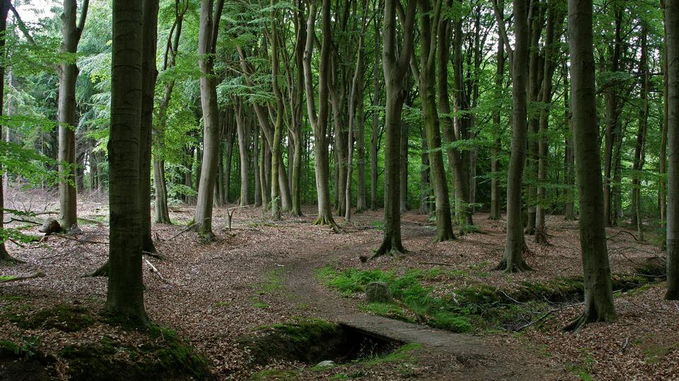
A dirt hiking trail leads through a dense, mature deciduous forest with a small wooden bridge over a drainage ditch in the foreground.
A shaded path through the woodland of the Boerskotten estate in Landgoederen Oldenzaal.

Landgoederen Oldenzaal history and protected-area timeline

The estates that now make up Landgoederen Oldenzaal have a long history as privately owned and managed country properties in the Twente region, with woodland management and small-scale agricultural use shaping the landscape over many generations. The hedgerow patterns, mature forest stands, and brook-side woodlands visible today are the product of that continuous stewardship rather than of any single dramatic intervention.

A decisive modern event came with the construction of the A1 motorway, which physically divided part of the Boerskotten woodland complex. In 1992, Dutch road authorities and conservation organisations worked together to restore ecological continuity by constructing a dedicated wildlife overpass, the Boerskotten ecoduct (officially the Ir. H.J.W. Snijders ecoduct), which was only the third such structure in the Netherlands at that time and became an early reference point for ecological infrastructure design in the country.

The area's formal protection history culminated on 3 September 2013, when Landgoederen Oldenzaal was officially designated as a Natura 2000 site under the European Habitats Directive, receiving the European site code NL3004003 and Dutch area number 50. The designation brought the existing estate landscape into the broader European network for habitat protection. In 2020, the Boerskotten ecoduct was retrofitted to better accommodate small amphibians, including the great crested newt, demonstrating the ongoing adaptive management of the site as ecological understanding and species needs evolve.

Landgoederen Oldenzaal landscape and geographic character

The defining physical feature of Landgoederen Oldenzaal is the stuwwal, or ice-pushed ridge, of Oldenzaal, which rises sharply above the surrounding lowlands of eastern Overijssel. The protected estates lie at the foot of this ridge, on the lower slopes and the plain immediately below, where the transition from sandy upland to wet lowland produces a rich gradient of soil and moisture conditions.

Across the three separate sub-areas, the landscape alternates between mature woodland on the better-drained slopes and wetter, mossy forest types in the valleys fed by springs emerging from the base of the stuwwal. These springs feed small brooks such as the Snoeyinksbeek near De Lutte, which carve shallow, vegetated valleys through the estates and contribute to the characteristic moist forest habitats.

Between and around the woodland blocks, the terrain reverts to the classic small-scale Twenthe agricultural landscape: narrow parcels of meadow and arable land separated by dense lines of hedgerows, with occasional estate lanes bordered by avenues of trees. Rhododendron-lined avenues, a feature of older Dutch estate plantings, are visible in parts of the area and add to the layered, semi-cultural character of the terrain. From elevated points such as the Tankenberg, the highest point of the local stuwwal, visitors can look out over the patchwork of woodland and field that defines the site.

The result is a landscape that reads as both natural and cultivated: shaped by long estate management, threaded by small watercourses, and anchored by the imposing wall of the ice-pushed ridge that forms its constant backdrop.
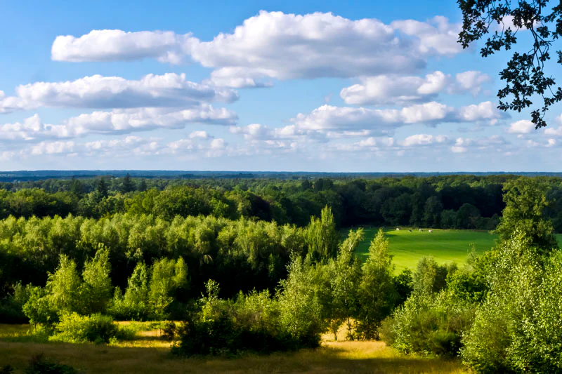
A wide, elevated view overlooking a landscape of dense green forests, grassy meadows, and patches of light, under a blue sky with scattered clouds.
A scenic view over the forested landscape and grasslands of the Tankenberg.

Landgoederen Oldenzaal ecosystems, habitats, and plant life

Ecologically, Landgoederen Oldenzaal is defined by the interaction between the sandy, well-drained soils of the stuwwal and constant groundwater seepage at its base. These conditions support some of the more richly developed spring and brook-side forest communities in Overijssel, often referred to in Dutch conservation language as bron- and beekbegeleidende bossen. Such forests are typically characterised by a moist, mossy ground layer, a diverse herb flora in spring, and trees such as oak and beech on the drier edges grading into alder-dominated woodland along the watercourses.

The small-scale mosaic of woodland, hedgerow, damp grassland, and arable field is itself a habitat of considerable ecological value. Hedgerows provide shelter, nesting sites, and foraging corridors for a wide range of species, while the interspersed meadows and small cultivated plots maintain the open, semi-structured character of the estate landscape. Pools in estate woodlands, such as those visible in Landgoed Egheria, add still further microhabitats for amphibians and aquatic invertebrates.

The connection to the adjacent Dinkelland Natura 2000 site to the south extends the effective ecological footprint of Landgoederen Oldenzaal, allowing species and ecological processes to move along a continuous band of suitable habitat rather than being confined to the protected area's administrative boundaries.
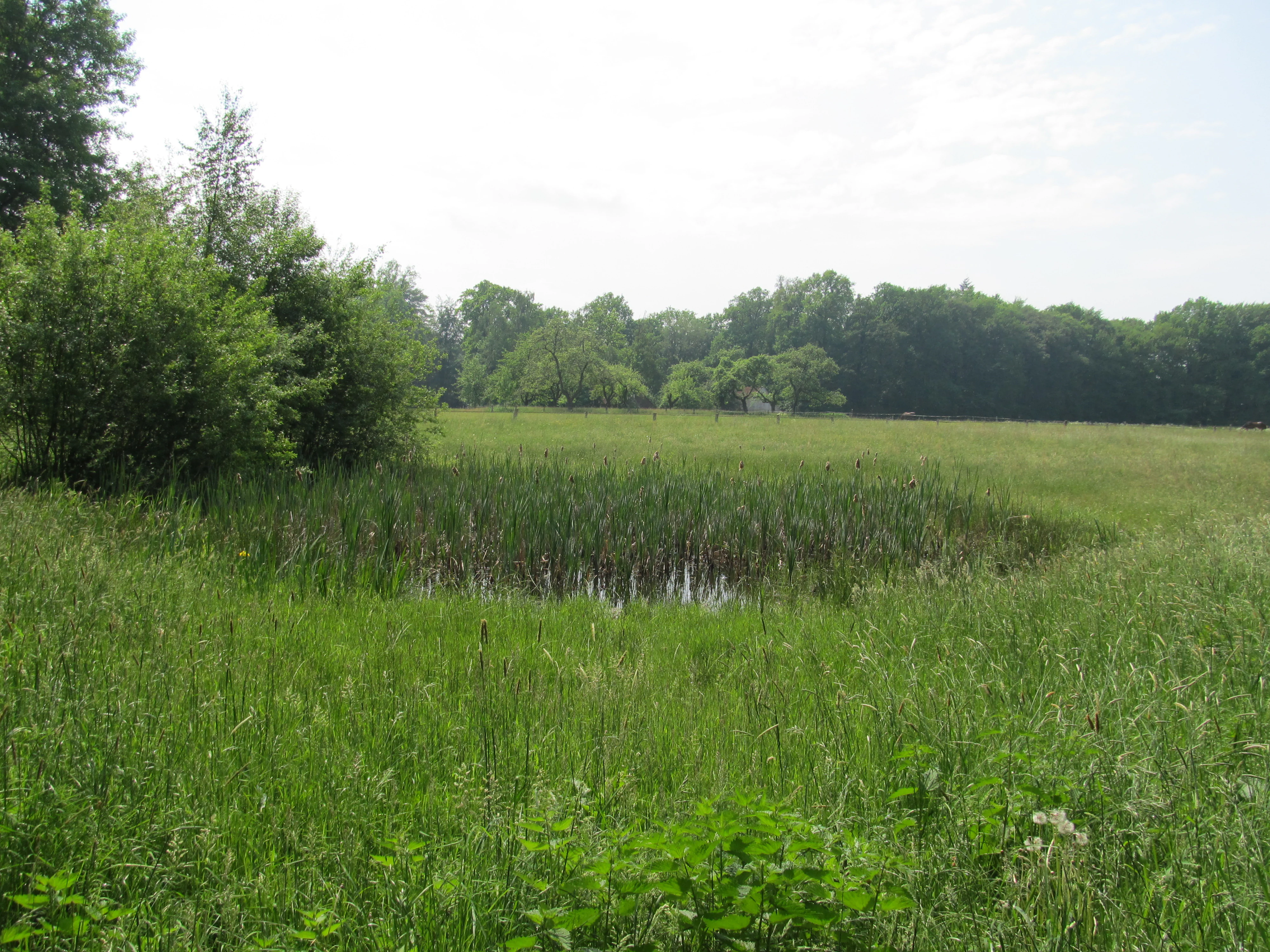
A small pond overgrown with reeds situated in the middle of a green field, with a line of trees in the background under a bright sky.
A small pond surrounded by lush grassland and trees in the Egheria Estate.

Landgoederen Oldenzaal wildlife and species highlights

The wildlife significance of Landgoederen Oldenzaal lies less in any single charismatic species than in the persistence of habitat conditions that support a wide community of forest and brook-valley fauna. The spring-fed forests and adjacent pools are particularly important for amphibians, with the great crested newt (kamsalamander) highlighted as a species of conservation concern whose continued presence depends on the small water bodies embedded within the estate landscape.

The hedgerow mosaic surrounding the woodlands provides habitat for woodland birds, small mammals, and invertebrates, while the continuous forest cover supports typical Overijssel woodland fauna. Small mammals, bats, and a range of forest-specialist bird species are among the groups likely to benefit from the connectivity maintained by the Boerskotten ecoduct, which allows animals to cross the A1 motorway without descending to road level.

The 2020 adaptation of the ecoduct to better protect small amphibians illustrates how the site's infrastructure has been deliberately tuned to support the wildlife most sensitive to fragmentation. This reflects a broader pattern in which the conservation value of the estate depends not only on what lives within the woodlands themselves but on the ability of animals to move between forest fragments across a heavily trafficked transport corridor.

Landgoederen Oldenzaal conservation status and protection priorities

Landgoederen Oldenzaal holds its conservation status primarily through designation as a Natura 2000 site under the European Habitats Directive, formalised on 3 September 2013. The designation ties the site into the wider European network of protected areas and obliges national and regional authorities to maintain the habitat types and species for which it was notified.

The conservation value of the site rests on several pillars: the unusually well-developed spring and brook-side forest communities at the foot of the stuwwal, the persistence of a small-scale hedgerow landscape that supports a wide range of species, and the historical continuity of estate management that has produced ecologically mature woodland. The site's ability to function as a coherent ecological unit was significantly enhanced by the construction of the Boerskotten ecoduct in 1992, which addressed a long-standing severance caused by the A1 motorway.

Ongoing conservation management at the site includes adaptive measures such as the 2020 upgrade of the ecoduct to improve conditions for small amphibians, a marker of how the area continues to be managed as a working example of habitat connectivity. The link with the neighbouring Dinkelland Natura 2000 site further strengthens the site's role as part of a regionally coherent conservation network along the Oldenzaal stuwwal.

Landgoederen Oldenzaal cultural meaning and human context

Landgoederen Oldenzaal sits within a region, Twente, where the cultural identity of the countryside is closely tied to the presence of historic landed estates, or landgoederen. These estates, many of which date back centuries, have shaped the rural landscape through their woodlands, avenues, hedgerows, and carefully managed fields, and they remain prominent features of local identity and heritage.

The landscape patterns visible in the protected area, including rhododendron-lined avenues and estate pools such as those of Landgoed Egheria, reflect this long tradition of ornamental and productive estate planting. Beyond their biodiversity value, these features are part of how the region understands itself, marking the area as historically cultivated rather than wild.

The construction of the early wildlife overpass at Boerskotten in 1992 also carries cultural significance. As one of the first ecoducts in the Netherlands, it represents an early moment in which Dutch society formally reconciled the demands of modern infrastructure with the value of its ecological and cultural landscape. Its naming and continued adaptation reflect a sustained local commitment to keeping that balance in view.

Top sights and standout views in Landgoederen Oldenzaal

Among the standout features of Landgoederen Oldenzaal, the spring-fed and brook-side estate forests at the foot of the stuwwal represent the ecological heart of the site and the principal reason for its Natura 2000 designation. Their combination of mature woodland structure, reliable groundwater input, and long continuity of management makes them unusually rich in habitat value.

The Boerskotten ecoduct is a second defining highlight, both as a piece of conservation infrastructure and as a milestone in Dutch environmental history. Built in 1992 as only the third wildlife overpass in the country and adapted in 2020 to better protect small amphibians, it embodies the site's role as a working example of how fragmented habitats can be reconnected in a modern landscape.

Finally, the broader integration of the site with the adjacent Dinkelland Natura 2000 area, and its setting against the dramatic backdrop of the Oldenzaal ice-pushed ridge, give the protected area a sense of regional coherence rare among smaller, fragmented Natura 2000 sites. Together these qualities make Landgoederen Oldenzaal a compact but unusually multifaceted conservation landscape.

Best time to visit Landgoederen Oldenzaal

The character of Landgoederen Oldenzaal shifts with the seasons in ways that reflect both its woodland ecology and its estate landscape. In spring, the ground flora of the moist forests and the verges of the small brooks comes into flower, and amphibians become active around the estate pools, including species such as the great crested newt for which the site is particularly noted.

Late spring and early summer are also typically when the surrounding hedgerow landscape is at its most vivid, with mature trees in full leaf and the small fields and meadows in active growth. Summer offers a green, fully leafed-out woodland experience, though the dense canopy can limit views of the broader landscape.

Autumn brings colour to the estate woodlands, with the beech and oak stands on the better-drained soils turning before the alder-dominated brook-side forest, and visibility through the thinner hedgerow network improves. Winter, while quieter ecologically, can provide clearer views across the mosaic of woodland and field from elevated vantage points such as the Tankenberg, though visitors should expect typical Dutch winter weather. Across all seasons, the site's small-scale agricultural and estate character means that quieter, less intensively visited periods generally offer the richest experience of its landscape qualities.


Monthly climate preview

Track representative monthly temperature ranges and precipitation patterns across the year

Landgoederen Oldenzaal Climate Profile, Long Term Temperature and Precipitation Normals

Historical monitoring data from 1991 through 2020 documents the measured monthly temperature progression and precipitation rhythm across representative coordinate points in Landgoederen Oldenzaal. Reviewing the complete twelve month record provides deeper insight into baseline climatic conditions and long term environmental trends.
Annual mean10 °C
2 °C18 °C
Jan
Feb
Mar
Apr
May13°
Jun16°
Jul18°
Aug18°
Sep14°
Oct10°
Nov
Dec
Warmest month
July

18.1 °C

Coolest month
January

1.7 °C

Wettest month
December

2.5 mm/day

Driest month
April

1.4 mm/day

Park location guide

Geography guide, regional context, and park location map for Landgoederen Oldenzaal

Landgoederen Oldenzaal park geography, regions, and map view in Netherlands

Understand where Landgoederen Oldenzaal sits in Netherlands through a broader geographic reading of the surrounding landscape, nearby location context, and its mapped position within the national park landscape.

How Landgoederen Oldenzaal fits into Netherlands

The Netherlands is a low-lying coastal country in Northwestern Europe, famous for its extensive dike and canal systems that reclaim land from the sea. It consists of twelve provinces and is known for tulips, windmills, and cycling culture. The country is a founding member of the European Union with Amsterdam as its capital and The Hague as the seat of government.

Wider geography shaping Landgoederen Oldenzaal in Netherlands

The Netherlands is located in Northwestern Europe along the North Sea coastline to the north and west. It borders Germany to the east and Belgium to the south. The country is notably flat, with a significant portion of its territory lying below sea level, protected by dikes and dune systems. It consists of twelve provinces and also includes overseas municipalities in the Caribbean.

Map view of Landgoederen Oldenzaal

Use this park location map to pinpoint Landgoederen Oldenzaal in Netherlands, understand its exact geographic position, and read its mapped placement within the surrounding landscape more clearly.

Pigeon | © OpenStreetMap contributors

Location context for Landgoederen Oldenzaal

Overijssel

Visualizing spring-fed estate forests, hedgerow terrain, and ice-pushed ridge topography.

Landgoederen Oldenzaal Photos and Landscape Scenery Visual Exploration

Examine detailed visual records of Landgoederen Oldenzaal to understand the complex mosaic of spring-fed estate forests and traditional agricultural hedgerows. Photographic documentation reveals the underlying terrain transitions and habitat characteristics across the protected tracts of eastern Overijssel.

A dirt hiking trail leads through a dense, mature deciduous forest with a small wooden bridge over a drainage ditch in the foreground.

A narrow red gravel walking trail flanked by dense, large bushes full of vibrant purple rhododendron flowers under a canopy of green trees.

A wide, elevated view overlooking a landscape of dense green forests, grassy meadows, and patches of light, under a blue sky with scattered clouds.

A small pond overgrown with reeds situated in the middle of a green field, with a line of trees in the background under a bright sky.

Park atlas

Compare regional nature reserves and connected conservation areas across Overijssel

Explore Parks Near Landgoederen Oldenzaal and Surrounding Protected Landscapes

Browse other protected areas and woodland reserves situated near Landgoederen Oldenzaal to examine regional ecological corridors. Comparing adjacent park geography reveals broader habitat patterns across the surrounding eastern Netherlands terrain.
Nature reserveOverijssel
About 8.4 km away#1 closest

Southwest

Landgoed Lonnekermeer Nature Reserve: Geographic Landscape and Protected Area Mapping

Twente region, Overijssel province, Netherlands

Landgoed Lonnekermeer is a 98 hectare nature reserve in Overijssel characterized by a designed early twentieth century landscape, lakes originating from historic sand quarries, and expansive wet heath. Explore the protected boundaries of this estate as it serves as a living model for habitat restoration, showcasing the successful recovery of local fens, brooks, and biodiversity-rich hay meadows within the eastern Netherlands.

Area
1.05 km²
Established
1902
Relief
Lowland
Climate
Temperate
Nature reserveNiedersachsen
About 11 km away#2 closest

Northeast

Syen-Venn Nature Reserve: Geographic Overview of Mired Landscapes in Lower Saxony

A study of raised bog regeneration, peatlands, and wetland bird habitats

Syen-Venn is a prominent nature reserve in Niedersachsen, characterized by its long-standing history of mire conservation and active bog surface regeneration. The landscape features diverse structural elements including cottongrass-covered hummocks, nutrient-poor standing waters, and moor birch woodlands that provide essential habitat within the broader regional geography of northern Germany.

Area
1.96 km²
Established
1936
Nature reserveGrafschaft Bentheim
About 12 km away#3 closest

East

Weiher am Syen-Venn Nature Reserve: Protected Landscapes and Geography in Grafschaft Bentheim

Exploring nutrient-poor ponds and meadow buffer zones

Weiher am Syen-Venn stands as a significant nature reserve in Grafschaft Bentheim, defined by its flat lowland terrain and aquatic-focused ecological zones. The protected area encompasses nearly 30 hectares of meadows and ponds, providing vital refuge for moor frogs and migratory bird species within an agricultural landscape framework.

Area
0.28 km²
Established
2016
Relief
Lowland
Climate
Temperate
Protected areaOverijssel
About 13 km away#4 closest

North

Springendal & Dal van de Mosbeek Protected Area: Mapped Geography and Terrain Overview

Glacial push-moraine landscapes in the Overijssel province

The Springendal & Dal van de Mosbeek protected area stands out for its concentrated geological diversity, where boulder-clay layers trigger consistent groundwater seepage. This natural process maintains rare ash-elm spring forests and calcareous mires within a twelve square kilometer expanse. The area preserves a classic Twente cultural pattern of small meadows and hedgerows, creating a protected sanctuary for specialized invertebrates and woodland wildlife.

Area
12.25 km²
Established
2013
Relief
Upland
Scope
Terrestrial
A soft watercolor illustration showing rolling green hills, a winding stream, and distant pastel-colored ridgelines on a white background.
Nature reserveOverijssel
About 13 km away#5 closest

North

Bergvennen & Brecklenkampse Veld Protected Area: Geographic Atlas and Landscape Map

Nature reserve featuring rare fens and glacial sand ridges in Overijssel

Bergvennen & Brecklenkampse Veld provides an essential case study in transboundary conservation within the eastern Netherlands. This nature reserve, characterized by its weakly buffered fens and juniper-studded heathlands, sits atop undulating cover sand ridges. Our mapping tools detail the gradient-rich terrain and the specific hydrological conditions that allow these habitats to thrive in the Twente region.

Area
1.33 km²
Established
2013
Relief
Lowland
Scope
Terrestrial
Nature reserveLandkreis Grafschaft Bentheim
About 14 km away#6 closest

East

FFH-Gebiet Bentheimer Wald: A Deep Dive into German Protected Woodland and Forest Terrain

Historic wood pasture in Landkreis Grafschaft Bentheim

Explore the geographical structure and protected status of FFH-Gebiet Bentheimer Wald. This woodland region is renowned for its Hutewald heritage, riparian streams, and ancient growth that supports rare lichen and bryophyte species across its expansive lowland forest canopy.

Area
7.8 km²
Relief
Lowland
Climate
Temperate
Access
Access unknown
Nature reserveOverijssel
About 18 km away#7 closest

South

Witte Veen Nature Reserve: Mapped Protected Landscapes and Bog Terrain in Overijssel, NL

Regional peatland geography and cross-border conservation status

Witte Veen is a protected nature reserve in eastern Overijssel, known for its distinct raised bog habitat and active restoration efforts. This site forms an essential link in the Dutch-German border chain, offering a unique look at fragmented wetland terrain, bog pools, and heathland ecosystems managed for ecological recovery.

Area
2.9 km²
Established
2013
Relief
Lowland
Climate
Temperate
Watercolor painting of a low-lying, marshy landscape with soft green meadows and sparse vegetation against a white background.
Nature reserveNorth Rhine-Westphalia
About 24 km away#8 closest

South

Lüntener Fischteiche Nature Reserve: Geography and Protected Area Landscape Map

A preserved mosaic of Münsterland heath and bog ecosystems

Lüntener Fischteiche is a specialized nature reserve in North Rhine-Westphalia, documented here for its distinct heath-pond character and ecological significance within the German-Dutch borderland. The site preserves remnants of bog and heath vegetation embedded within a pine forest matrix, serving as an important hub for regional waterbird populations and transboundary habitat connectivity.

Area
1.011 km²
Established
1959
IUCN
IV

Common questions about visiting, size, designation, and location context for Landgoederen Oldenzaal

Landgoederen Oldenzaal FAQs for park facts, access, geography, and protected area context

Find quick answers about Landgoederen Oldenzaal, including protected-area facts, park geography, trail and visitor context, and how the park fits into its surrounding country and regional landscape.
MoriAtlas Explorer

Continue Your Protected Areas Search Across the Global Atlas

Deepen your exploration by continuing the structured search for national parks and protected areas worldwide. Utilize the comprehensive filtering capabilities to compare different conservation landscapes and refine your understanding of global park geography. Discover more about the distribution and characteristics of protected natural areas.

Global natural geography