
Mori Atlas logo
Protected landscapeLandschaftsschutzgebiet Balve – Mittleres Hönnetal

Mapping the forested river valley and agricultural transitions of this German protected area

Landschaftsschutzgebiet Balve Mittleres Hönnetal: A Protected Landscape in Maerkischer Kreis

Landschaftsschutzgebiet Balve Mittleres Hönnetal represents a significant protected area spanning thousands of hectares across the Maerkischer Kreis district. This landscape is defined by the central Hönne river valley, where dense beech and spruce forests meet managed grasslands, arable fields, and local settlements. The terrain encompasses diverse woodland tracts and cultural heritage sites, providing a comprehensive look at the intersection of forestry traditions, contemporary renewable energy development, and regional land preservation.

landscape protection areabeech forestspruce forestriver valleyHönne valleySauerland
Stylized graphic illustration showing a cascading waterfall falling between steep mountain cliffs into a valley with a river and surrounding pine forest.

Landschaftsschutzgebiet Balve – Mittleres Hönnetal

Protected landscape

Park overview

Structured park overview, official facts, and landscape profile for Landschaftsschutzgebiet Balve, Mittleres Hönnetal

Landschaftsschutzgebiet Balve, Mittleres Hönnetal park facts, protected area profile, and essential visitor context

Review the core facts for Landschaftsschutzgebiet Balve, Mittleres Hönnetal, including designation, size, terrain, visitor scale, habitats, and operating context in one park-focused overview.

About Landschaftsschutzgebiet Balve, Mittleres Hönnetal

Landschaftsschutzgebiet Balve – Mittleres Hönnetal is one of the larger landscape protection areas in the Märkischer Kreis and represents a span of countryside that surrounds and connects the different parts of the town of Balve. Geographically, it traces the middle course of the Hönne river, a valley system that has historically shaped settlement, agriculture, and forest use in this corner of the Sauerland region of North Rhine-Westphalia. The protected perimeter reaches frequently out to the built-up edges of villages, providing an unusually tight interface between rural protected land and inhabited areas.

Functionally, the area is a Type A general landscape protection area, meaning that its designation emphasizes the preservation and development of the natural balance, the visual character of the countryside, and its value for low-impact recreation. The landscape is dominated by forest stands, mainly composed of Norway spruce and European beech, alongside open areas of grassland and arable fields that maintain the traditional mosaic of land use in the Hönne valley. There are also smaller managed zones where Christmas tree production, decorative greenery cutting, and tree nursery operations are carried out, preserving a regional dimension of small-scale forestry and cultivation.

Culturally, the protected landscape includes the heritage-listed Köhlerhaus on the Vogelsberg, a remnant of historical charcoal burning that was once widespread in the wooded hills of the region. In more recent years, the area has also come to host wind energy installations. Before 2023, wind turbines were restricted to open agricultural land, but since then additional units have been erected within the forested parts of the protected landscape, marking a notable change in how energy infrastructure and forest conservation intersect in the area. The combination of traditional cultural artifacts, working forests, agricultural land, and emerging renewable energy developments gives the protected area a layered character that reflects both the historical depth and the current pressures of the German countryside.

Quick facts and research context for Landschaftsschutzgebiet Balve, Mittleres Hönnetal

The protected landscape lies entirely within the municipal territory of Balve in the Märkischer Kreis. It was first designated in 1989 by the district council under the Landschaftsplan Balve – Mittleres Hönnetal as a Type A general landscape protection area (Allgemeiner Landschaftsschutz), originally named Landschaftsschutzgebiet Mittleres Hönnetal. In 2015, a second designation was carried out through the 2nd amendment of Landscape Plan No. 2, which reduced the area by about 167.80 hectares. The legal protections prohibit most new construction, the establishment of new Christmas tree or nursery plantations, and new reforestation without approval from the lower nature conservation authority.

Protection and recognition

Terrestrial protected area established in 2015 with documented management scope.

Landschaftsschutzgebiet Balve – Mittleres Hönnetal Protection Status and Designation History

Terrestrial protected area records establish the 2015 designation history and management scope for Landschaftsschutzgebiet Balve – Mittleres Hönnetal. Official records outline the formal conservation framework without international recognition sources.

Protection details

Protection scope
Terrestrial
Designated year
2015
Transboundary protection
No
Park context

Deeper park guide and search-rich context for Landschaftsschutzgebiet Balve, Mittleres Hönnetal

Landschaftsschutzgebiet Balve, Mittleres Hönnetal history, landscape, wildlife, and travel context

Explore Landschaftsschutzgebiet Balve, Mittleres Hönnetal through its history, landscape character, ecosystems, wildlife, conservation priorities, cultural context, and seasonal travel timing in a structured park guide built for atlas discovery and search intent.

Why Landschaftsschutzgebiet Balve, Mittleres Hönnetal stands out

The protected area is best known for its extensive forests of beech and spruce that frame the central Hönne valley, its proximity to traditional charcoal production heritage represented by the listed Köhlerhaus on the Vogelsberg, and its role as a working landscape where forestry, agriculture, and renewable energy infrastructure coexist within formal landscape protection boundaries.
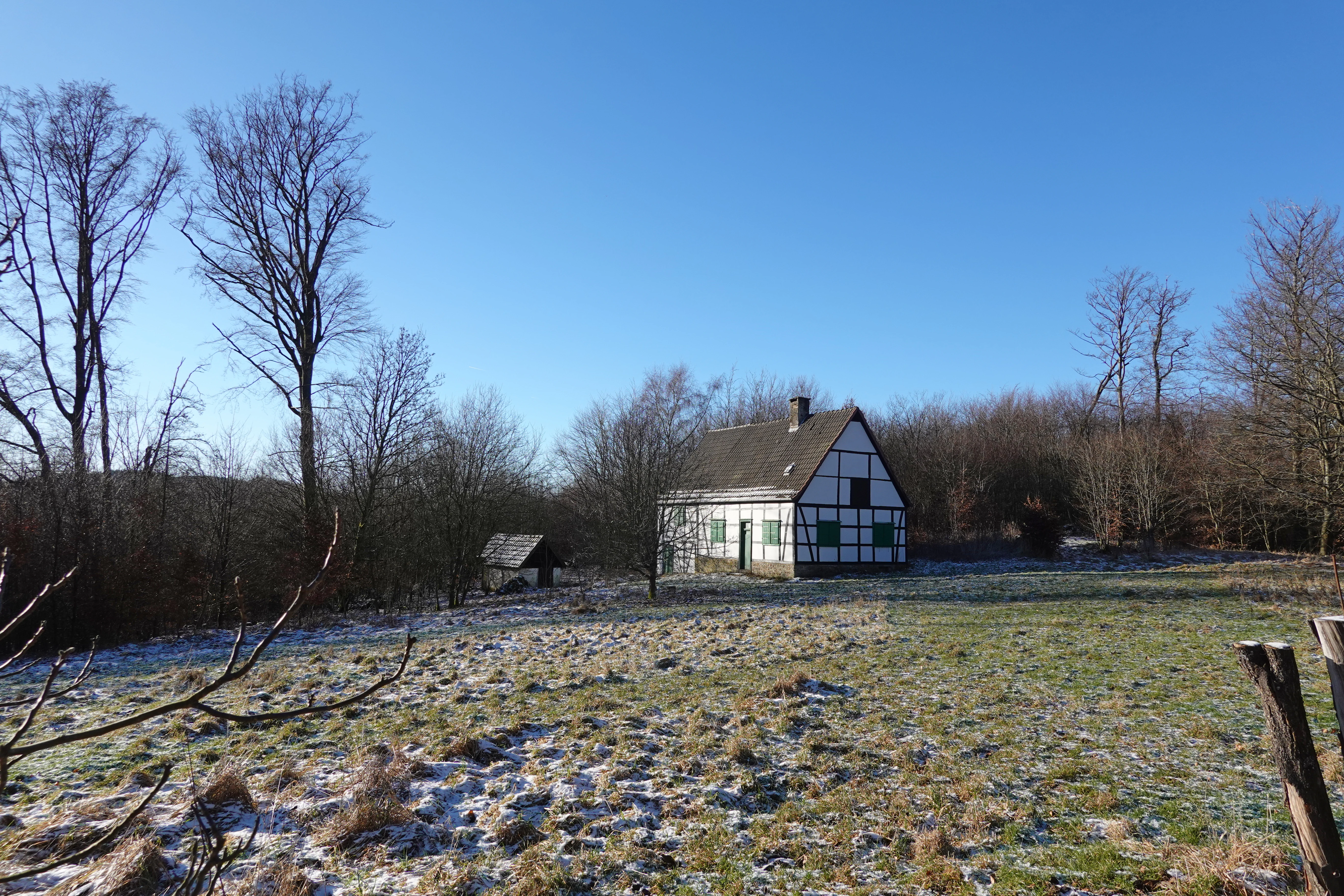
A traditional white and dark brown half-timbered house sits in a grassy clearing surrounded by bare forest trees under a clear blue sky on a cold day.
A traditional half-timbered house located in a forest clearing near Vogelsberg in the Balver Wald.

Landschaftsschutzgebiet Balve, Mittleres Hönnetal history and protected-area timeline

The protection of the middle Hönne valley landscape traces back to 1989, when the district council (Kreistag) of the Märkischer Kreis adopted Landschaftsplan Nr. 2 Balve-Mittleres-Hönnetal and designated the area as a landscape protection area (Landschaftsschutzgebiet) of Type A, classified under general landscape protection. The original designation used the name Landschaftsschutzgebiet Mittleres Hönnetal and covered approximately 4,913.46 hectares.

A second designation process took place in 2015 through the 2nd amendment of the landscape plan. This revised designation reaffirmed the protection of the area but reduced its total size by around 167.80 hectares, setting the current extent at about 4,745.66 hectares. The re-designation coincided with evolving management priorities, including the integration of small-scale forestry uses and an updated regulatory framework for new plantations, reforestation, and construction activities.

Landschaftsschutzgebiet Balve, Mittleres Hönnetal landscape and geographic character

The protected landscape follows the middle course of the Hönne river valley, an area where forested slopes, valley floor grasslands, and agricultural fields meet the edges of towns and villages. The woodland cover is high, and the canopy is largely composed of spruce stands together with beech-dominated forest patches, reflecting the regional forestry traditions of the Sauerland and the Märkischer Kreis. The forested hill of Vogelsberg is one recognizable landmark within the protected area, hosting the listed Köhlerhaus.

The open parts of the landscape include managed grasslands used for traditional farming and arable plots that continue to be cultivated. Smaller specialized plots host Christmas tree plantations, ornamental greenery production, and tree nursery operations. The protected boundary is unusual for frequently meeting residential and village edges directly, so the transition between settlement and protected countryside is unusually close. The terrain includes valley floors and the rising slopes that flank the Hönne, giving the protected area a varied topographic profile typical of mid-valley landscapes in this part of Germany.

Landschaftsschutzgebiet Balve, Mittleres Hönnetal ecosystems, habitats, and plant life

Ecologically, the area centers on the forest ecosystems that dominate the middle Hönne valley, with extensive beech and spruce stands providing the core habitat character. These forests alternate with smaller zones of grassland and arable fields, producing the kind of mosaic that supports a range of common forest and farmland species typical of western Germany. Although the area holds no strict nature reserve status, it functions as a broad buffer and connective landscape, linking settlements and more strictly protected zones.

The wooded compartments, including areas around Vogelsberg, support the kind of habitat structure associated with traditional Sauerland forestry, while the open land contributes additional landscape diversity. As a Type A landscape protection area, the ecological management focus is on maintaining the functional health of the natural balance, protecting habitats, and allowing for sustainable land use, rather than on enforcing the stricter controls typical of nature reserves.

Landschaftsschutzgebiet Balve, Mittleres Hönnetal conservation status and protection priorities

As a designated landscape protection area under German federal and state nature protection law, Balve – Mittleres Hönnetal carries a Type A general landscape protection status that targets the maintenance, development, or restoration of the functional capacity of the natural balance, the regenerative ability of natural resources, the diversity and beauty of the landscape, and its cultural-historical significance and recreational value. The protected area also serves the conservation of habitats and living spaces for native species across a large connected landscape.

The regulatory framework enforces these goals through restrictions such as a general prohibition on the construction of buildings, with limited exceptions for agricultural structures such as milking stands and open shelters for livestock, and for customary pasture and forestry fences. New Christmas tree plantations, decorative greenery, nursery areas, and new afforestation require approval from the lower nature conservation authority, ensuring that land-use changes remain consistent with the broader conservation purpose of the area.

Landschaftsschutzgebiet Balve, Mittleres Hönnetal cultural meaning and human context

The protected landscape is closely linked to the long tradition of woodland-based livelihoods in the Hönne valley, particularly the historical practice of charcoal burning that was once widespread in the forested uplands of the region. The heritage-listed Köhlerhaus on the Vogelsberg preserves physical evidence of this past and is a notable cultural landmark within the protected area's boundaries. The continued presence of small-scale forestry uses, such as Christmas tree cultivation and ornamental greenery production, also reflects an enduring regional connection between forest management and local livelihoods.

Top sights and standout views in Landschaftsschutzgebiet Balve, Mittleres Hönnetal

Among the distinctive features of the protected landscape are the heritage-listed Köhlerhaus on the Vogelsberg, the extensive beech and spruce forest tracts along the middle Hönne, the close proximity of protected countryside to the residential edges of Balve, and the presence of commercial Christmas tree and nursery plantations alongside more traditional farmland. The recent expansion of wind energy into the forested parts of the protected area since 2023 adds a layer of contemporary significance to the landscape, illustrating the evolving balance between renewable energy development and long-standing landscape protection goals.

Best time to visit Landschaftsschutzgebiet Balve, Mittleres Hönnetal

The forested middle Hönne valley changes character strongly with the seasons, with beech and spruce canopies providing a different visual and atmospheric experience in spring, summer, autumn, and winter. Late spring and early autumn are typically the most inviting periods for walks in mixed broadleaf and conifer forest, when temperatures are mild and forest paths are in good condition. Winter can reveal the structure of the woodlands more clearly and offers a quieter atmosphere, while the listed Köhlerhaus and traditional rural architecture can be appreciated year-round as part of the area's cultural landscape.

Monthly climate preview

Long-term representative coordinate measurements tracing regional weather by month

Annual Temperature and Precipitation Normals for Landschaftsschutzgebiet Balve – Mittleres Hönnetal

Historical climate data for Landschaftsschutzgebiet Balve – Mittleres Hönnetal establishes a measured annual rhythm of monthly average temperatures and precipitation rates from 1991 to 2020. Examining the complete twelve-month record provides deeper perspective on long-term temperature ranges and precipitation normals across the protected landscape.
Annual mean9 °C
1 °C19 °C
Jan
Feb
Mar
Apr
May13°
Jun16°
Jul19°
Aug18°
Sep14°
Oct10°
Nov
Dec
Warmest month
July

18.5 °C

Coolest month
January

0.9 °C

Wettest month
December

3 mm/day

Driest month
April

1.7 mm/day

Park location guide

Geography guide, regional context, and park location map for Landschaftsschutzgebiet Balve, Mittleres Hönnetal

Landschaftsschutzgebiet Balve, Mittleres Hönnetal park geography, regions, and map view in Germany

Understand where Landschaftsschutzgebiet Balve, Mittleres Hönnetal sits in Germany through a broader geographic reading of the surrounding landscape, nearby location context, and its mapped position within the national park landscape.

How Landschaftsschutzgebiet Balve, Mittleres Hönnetal fits into Germany

Germany is a federal republic in Western and Central Europe with a population of over 83 million across sixteen constituent states. It is Europe's largest economy by nominal GDP and a major global exporter and importer. The capital is Berlin, and the country borders Denmark, Poland, Czech Republic, Austria, Switzerland, France, Luxembourg, Belgium, and the Netherlands.

Wider geography shaping Landschaftsschutzgebiet Balve, Mittleres Hönnetal in Germany

Germany is located in Western and Central Europe, spanning 357,022 km². It borders Denmark to the north, Poland and the Czech Republic to the east, Austria and Switzerland to the south, and France, Luxembourg, Belgium, and the Netherlands to the west. The country has coastlines on the Baltic Sea and North Sea to the north, with the Alps located in the southern region.

Map view of Landschaftsschutzgebiet Balve, Mittleres Hönnetal

Use this park location map to pinpoint Landschaftsschutzgebiet Balve, Mittleres Hönnetal in Germany, understand its exact geographic position, and read its mapped placement within the surrounding landscape more clearly.

Pigeon | © OpenStreetMap contributors

Location context for Landschaftsschutzgebiet Balve, Mittleres Hönnetal

Maerkischer Kreis

Visual exploration of forest terrain, river valley habitats, and protected landscapes

Landschaftsschutzgebiet Balve – Mittleres Hönnetal Photos and Scenery

Visual documentation captures the forested slopes, valley floor grasslands, and cultural landmarks defining Landschaftsschutzgebiet Balve – Mittleres Hönnetal. Photographic records provide clear visual context for the terrain, woodland composition, and working rural environments spanning the region.

A traditional white and dark brown half-timbered house sits in a grassy clearing surrounded by bare forest trees under a clear blue sky on a cold day.

A meadow clearing in early winter with light frost on the ground, bordered by a leafless forest and a small hunting stand in the distance.

Park atlas

Compare adjacent river valleys and surrounding Sauerland conservation landscapes

Parks Near Landschaftsschutzgebiet Balve – Mittleres Hönnetal and Regional Protected Areas

Browsing other protected areas near Landschaftsschutzgebiet Balve – Mittleres Hönnetal reveals broader regional forestry patterns and valley floor terrain. Comparing adjacent conservation zones provides deeper context on mixed woodland ecosystems and protected rural boundaries.
A watercolor illustration depicting a wide valley with green hills, white limestone rock formations, and a small reddish cave entrance.
Protected landscapeNordrhein-Westfalen
About 6.8 km away#1 closest

Northeast

Hönnetal Protected Landscape: Mapping the Karst Valley and Limestone Cliffs of Nordrhein-Westfalen

A deep dive into the geology, conservation, and physical terrain of the Hönne river valley.

The Hönnetal stands as one of Central Europe's most striking karst landscapes, characterized by white limestone cliffs rising 60 meters above the riverbed. This protected area within Nordrhein-Westfalen represents a critical intersection of ancient geological processes, including dense cave networks and unique beech forests, alongside a historic civic conservation movement that preserves its defining natural boundaries.

Area
1.442 km²
Established
1920
Relief
Upland
Climate
Temperate
A soft watercolor painting of a green, rolling valley with a stream winding through the grassy foreground against a background of distant, misty hills.
Nature reserveNordrhein-Westfalen
About 7.4 km away#2 closest

East

Naturschutzgebiet Orlebachtal Protected Stream Valley and Floodplain Geography

A preserved meandering valley in the Sauerland foothills

This nature reserve protects a small but geomorphically active stream valley featuring a clean, oxygen-rich brook and diverse floodplain meadows. Managed through traditional grazing to sustain rare grassland species, the valley provides a representative look at the terrain and riparian ecology of the North Rhine-Westphalia region.

Area
0.151 km²
Established
1989
Relief
Upland
Scope
Terrestrial
Nature reserveNordrhein-Westfalen
About 8.3 km away#3 closest

South

Naturschutzgebiet Schlänke: Woodland Conservation in the Märkischer Kreis Region

Protected beech-forest terrain and spring-blooming flora

Spanning roughly 0.6 hectares, Naturschutzgebiet Schlänke is a focused nature reserve dedicated to the preservation of native deciduous woodland. The site occupies a north-facing slope, creating specific moisture conditions that sustain a notable population of spring snowflakes, marking it as a significant botanical patch within the broader forested landscape of Plettenberg.

Area
0.006 km²
Established
1985
Relief
Upland
Climate
Temperate
A soft watercolor illustration of a wide river landscape with rolling green hills in the background and grassy riverbanks in the foreground.
Nature reserveNordrhein-Westfalen
About 10 km away#4 closest

West

Naturschutzgebiet Pragpaul: Nature Reserve and Protected Lenne Valley Landscapes

Geographic atlas and protected area boundary overview

Naturschutzgebiet Pragpaul preserves a narrow, steeply sloping strip of forest between Altena and Nachrodt-Wiblingwerde. The site integrates rocky cliff outcrops, dense beech woodlands, and near-natural riverine sections along the Lenne, forming a vital component of the Schluchtwälder im Lennetal protected network.

Area
0.7 km²
Established
1999
IUCN
IV
A soft watercolor illustration depicting rolling green hills, dense forest patches, and a winding stream flowing through a grassy meadow.
Protected landscapeGermany
About 11 km away#5 closest

Northeast

Luerwald und Bieberbach Protected Landscape: Regional Forest Map and Habitat Overview

A major continuous woodland reserve in North Rhine-Westphalia, Germany.

Spanning the landscape between Neheim and Menden, Luerwald und Bieberbach functions as a critical Special Protection Area. The terrain features extensive beech and oak woodlands intersected by the Bieberbach stream, creating an important haven for woodland species and maintaining a large, undisturbed environmental mosaic across the northern Sauerland.

A watercolor painting depicting a soft-focus landscape with rolling green hills, a small pond or marshy water feature in the foreground, and distant hazy hills in the background.
Nature reserveHochsauerlandkreis
About 12 km away#6 closest

East

Naturschutzgebiet Piepenbruch: Protected Spring-Fed Grassland in Hochsauerlandkreis

A localized nature reserve protecting rare wet meadow ecosystems

Naturschutzgebiet Piepenbruch serves as a textbook example of a small-scale, high-value nature reserve. The site provides a critical refuge for rush vegetation and moisture-dependent wildflowers, acting as an important ecological buffer within the broader Flasmecketal landscape protection area of the Hochsauerlandkreis.

Area
0.023 km²
Established
2019
IUCN
IV
Relief
Upland
Nature reserveNorth Rhine-Westphalia
About 14 km away#7 closest

Northeast

Naturschutzgebiet Schakenberg: Protected Beech Forest Landscape and Regional Geography

A rare calcareous woodland reserve in the Hachener Kuppenland

Naturschutzgebiet Schakenberg safeguards a near-natural Waldmeister-Buchenwald forest on a limestone hilltop. This protected area acts as a crucial ecological anchor within the Luerwald and Bieberbach Natura 2000 network, showcasing the distinct hilly topography and forest biodiversity characteristic of the eastern Sauerland.

Area
0.022 km²
Established
1998
Relief
Upland
Climate
Temperate
Nature reserveNorth Rhine-Westphalia
About 14 km away#8 closest

East

Naturschutzgebiet Schla Nature Reserve: Geographic Profile and Protected Forest Landscape

Limestone hilltop woodland in North Rhine-Westphalia

Naturschutzgebiet Schla serves as a representative example of calcareous oak-hornbeam forests in the Hochsauerlandkreis. This small, 3.4-hectare nature reserve preserves ancient, 200-year-old oaks and a specialized geophyte-rich herb layer. Its hilltop position, characterized by thin limestone soils and proximity to an abandoned quarry, creates a unique microclimate that supports forest biodiversity and research into habitat connectivity in rural Germany.

Area
0.034 km²
Established
1993
Relief
Upland
Scope
Terrestrial

Common questions about visiting, size, designation, and location context for Landschaftsschutzgebiet Balve, Mittleres Hönnetal

Landschaftsschutzgebiet Balve, Mittleres Hönnetal FAQs for park facts, access, geography, and protected area context

Find quick answers about Landschaftsschutzgebiet Balve, Mittleres Hönnetal, including protected-area facts, park geography, trail and visitor context, and how the park fits into its surrounding country and regional landscape.
MoriAtlas Explorer

Continue Your Protected Areas Search Across the Global Atlas

Deepen your exploration by continuing the structured search for national parks and protected areas worldwide. Utilize the comprehensive filtering capabilities to compare different conservation landscapes and refine your understanding of global park geography. Discover more about the distribution and characteristics of protected natural areas.

Global natural geography