
Mori Atlas logo
Nature reserveLatumer Bruch

Mapping the floodplain forests and historic Rhine meander channels of a vital regional refuge

Latumer Bruch Nature Reserve and Protected Wetland Landscapes in Nordrhein-Westfalen Germany

(Naturschutzgebiet Latumer Bruch)

Latumer Bruch serves as a significant nature reserve on the southeastern edge of Krefeld, protecting a mosaic of swamp woodlands, wet ditches, and species-rich grassland ridges. Situated within the broader Lower Rhine valley, this protected area features old river meander channels that continue to function as natural floodwater retention basins. The site stands as a central component of an interconnected corridor of protected lands, providing critical habitats for migratory birds and amphibians across a lowland terrain.

swamp forestfloodplain forestwetlandLower Rhinenature reservemeadow birds
Stylized digital illustration of a mountain landscape with a waterfall, conifer forest, and a split-rail fence in the foreground.

Latumer Bruch

Nature reserve

Park overview

Structured park overview, official facts, and landscape profile for Latumer Bruch

Latumer Bruch park facts, protected area profile, and essential visitor context

Review the core facts for Latumer Bruch, including designation, size, terrain, visitor scale, habitats, and operating context in one park-focused overview.

About Latumer Bruch

Latumer Bruch is a compact but ecologically rich nature reserve that defines the southern green edge of Krefeld. It occupies a former meander belt of the Lower Rhine, where the river once carved shifting channels across a wide glacial valley plain. Today, two of these abandoned channels, the Buersbach and the Linner Mühlenbach, run through the area as slow, groundwater-fed streams. When the Rhine rises, pressurised groundwater pushes up into these channels, turning the surrounding floodplain into a temporary retention landscape that buffers downstream communities from flooding.

The protected area itself combines several distinct habitat types. The wettest zones are dominated by swamp woodland (Bruchwald) and floodplain woodland (Auwald), where alder, willow and poplar thrive alongside reeds, sedges and bur-reed stands. Pools and wet ditches add structural diversity, while the higher sandy ridges known locally as Donke carry dry, species-rich grassland marked by autumn crocus and cuckoo flower. Together these contrasting wet and dry microhabitats produce an unusually varied botanical community within a relatively small footprint.

The reserve takes its name from Haus Latum, a traditional manor farm on the edge of Lank-Latum, whose historic lands once included the wetland. It has been designated as a nature reserve since 1982. Beyond its own boundaries, Latumer Bruch is integrated into a wider ecological network: it forms the core of the Natura 2000 / FFH site 'Latumer Bruch mit Buersbach, Stadtgräben und Wasserwerk' together with the Buersbach reserve, the Linn Castle moat system, the Greiffenhorstpark and the Elt drinking-water catchment. It is also part of the 'Biotopverbund Krefelder Süden' biotope-connection programme, which links southern Krefeld's protected sites into a single ecological corridor.

Management of the area is carried out by the City of Krefeld's lower landscape authority, with on-the-ground involvement from NABU (Naturschutzbund Deutschland) and a volunteer landscape warden. Grazing is maintained on a low-intensity basis in the surrounding meadows, helping to preserve the open grassland mosaic that supports meadow birds and butterflies.

Quick facts and research context for Latumer Bruch

Latumer Bruch is a nature reserve located in the southeast of Krefeld in North Rhine-Westphalia, Germany, classified as an IUCN Category IV habitat and species management area. Covering roughly 185 hectares, it is administered under the designation KR-001 and forms part of the larger Natura 2000 site DE-4605-301 together with Buersbach, the Linn moat system, and the Elt waterworks area.

The reserve sits on former meander channels of the Lower Rhine and combines swamp forest (Bruchwald), floodplain woodland (Auwald), wet ditches, ponds, and semi-natural grassland. Since 1982 it has been protected for its wetland habitats, its rich bird and amphibian fauna, and its role as a natural water-retention landscape during high Rhine floods.

Protection and recognition

Terrestrial protected area metrics and international recognition data

Latumer Bruch Protection Status and Documented Conservation Framework

Latumer Bruch maintains a documented terrestrial protection status within global conservation databases. Official records outline the baseline designation scope and management framework assigned to the protected natural terrain.

Protection details

Protection scope
Terrestrial
Transboundary protection
No
WDPA ID
164382
Park context

Deeper park guide and search-rich context for Latumer Bruch

Latumer Bruch history, landscape, wildlife, and travel context

Explore Latumer Bruch through its history, landscape character, ecosystems, wildlife, conservation priorities, cultural context, and seasonal travel timing in a structured park guide built for atlas discovery and search intent.

Why Latumer Bruch stands out

Latumer Bruch is best known for its combination of swamp woodland and species-rich wetland habitats on the Lower Rhine, set within the old meander channels (Kendel) of a once-wandering Rhine. The reserve is recognised as a refuge for waterbirds and meadow birds, including breeding white storks and black kites, and as a roosting and feeding area for migratory species. It is also valued for its role as a natural floodwater retention basin and as the hub of a connected wetland landscape south of Krefeld. Ecologically, the area stands out for the interplay between wet alder, willow and poplar forests, marsh vegetation with marsh iris and marsh marigold, and dry nutrient-poor grassland with autumn crocus and lady's smock on the higher 'Donke' ridges.
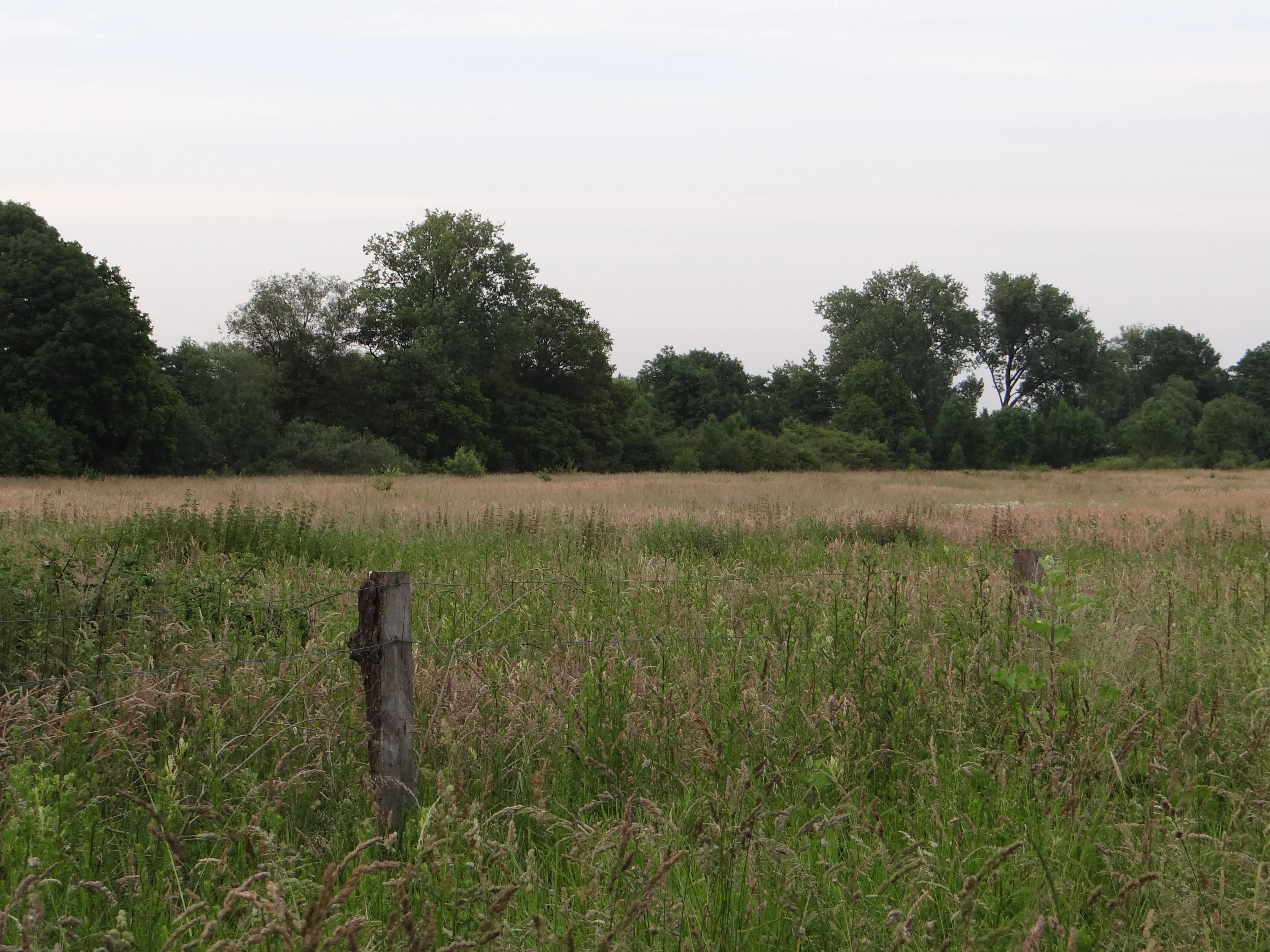
A wide view of a grassy meadow with a wooden fence post in the foreground and a dense line of trees in the background under an overcast sky.
A meadow and woodland edge within the Latumer Bruch nature reserve.

Latumer Bruch history and protected-area timeline

The Latumer Bruch takes its name from Haus Latum, a historic manor farm on the edge of Lank-Latum, whose lands historically encompassed the wetland. For centuries the area was part of the agricultural and estate landscape of the Lower Rhine, shaped by the meander channels and seasonal flooding of the Rhine.

Its formal conservation history began in 1982, when the site was designated as a nature reserve (Naturschutzgebiet) under the designation KR-001. This step recognised both its ecological value as a floodplain forest and its role as a natural floodwater retention area. Over time, the reserve became embedded in larger conservation frameworks. It is now part of the EU Natura 2000 / FFH site DE-4605-301, which links it to the adjacent Buersbach reserve, Linn Castle's moat and city ditch system, the Greiffenhorstpark and the Elt waterworks area. It is also incorporated in the Biotopverbund Krefelder Süden, a regional programme connecting protected habitats across southern Krefeld. Today the area is managed by Krefeld's lower landscape authority together with NABU and a volunteer landscape warden.

Latumer Bruch landscape and geographic character

Latumer Bruch sits within the flat, broad valley plain of the Lower Rhine, on terrain that was once shaped by a wandering, meandering Rhine. The local name 'Kendel' refers to these old river channels, several of which still cross the area as slow, often seasonally water-filled depressions. Two of them, the Buersbach and the Linner Mühlenbach, define the hydrological character of the reserve.

The topography is subtle but ecologically decisive. The lowest, wettest corridors are filled with swamp woodland, water-filled ditches, and small ponds that stay damp year-round. Slightly higher ground, the so-called Donke, rises as sandy ridges that remain dry even in wet seasons and carry open grassland instead of forest. This fine-scale alternation of wet channels and dry ridges creates a mosaic of micro-relief unusual for such a lowland setting.

During high water on the Rhine, groundwater rising under pressure fills the old channels from below because the water cannot drain away quickly enough. The result is a natural floodplain landscape that slows and stores water on its way downstream, giving Latumer Bruch a hydrological as well as ecological role in the regional landscape.
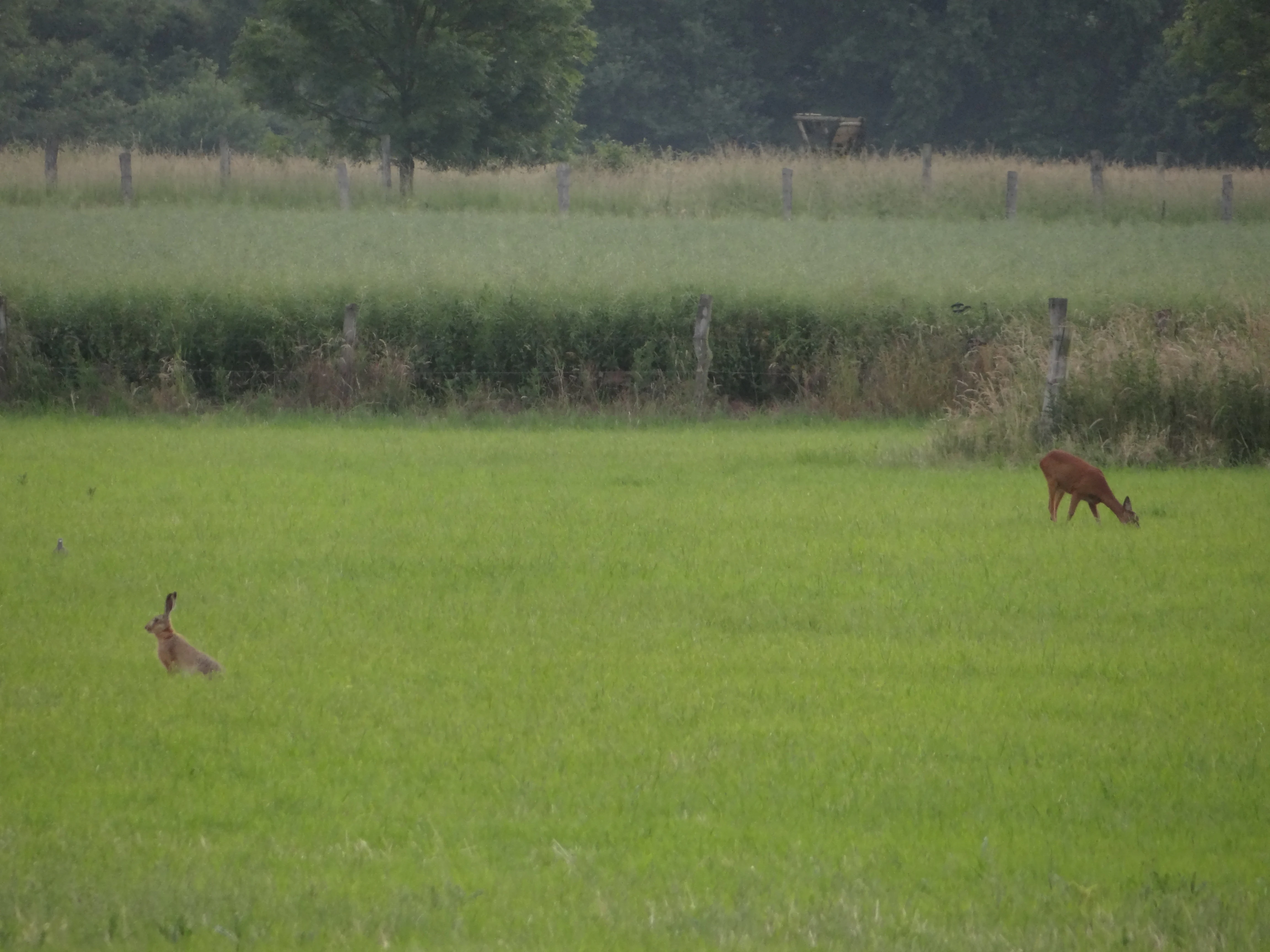
A brown roe deer and a European hare grazing on a grassy meadow with a fence and tree line in the background.
A European hare and a roe deer grazing together in the meadows of Latumer Bruch nature reserve.

Latumer Bruch ecosystems, habitats, and plant life

Ecologically, Latumer Bruch is defined by the contrast between its swamp-and-floodplain forest core and its surrounding dry grassland ridges. In the wettest areas, alder, willow and poplar form classic Bruchwald and Auwald communities, their roots anchored in waterlogged, peaty soils. Beneath and beside them grow a layered understorey of reeds, sedges and bur-reed, along with characteristic wetland flowers such as marsh iris (Sumpf-Schwertlilie) and marsh marigold (Sumpfdotterblume).

On the dry Donke ridges, conditions shift dramatically. Here, low-intensity grazing and nutrient-poor sandy soils have allowed a semi-natural dry grassland (Magerrasen) to persist. Autumn crocus (Herbstzeitlose) and cuckoo flower (Wiesenschaumkraut) are among the indicator species of these open meadows, which contrast sharply with the dense wetland forest only a short distance away.

This juxtaposition of habitats within a single small area supports a particularly wide range of invertebrates and plants for a protected site in such an urbanised setting. The mosaic also provides year-round feeding, breeding and shelter conditions for birds, amphibians and insects that depend on transitions between open water, wet woodland and open grassland.

Latumer Bruch wildlife and species highlights

Latumer Bruch is recognised above all for its birdlife. The wet meadows, ditches and ponds provide rich feeding for waterbirds and meadow birds, and the reserve is known as a breeding area for species such as the white storch and the black kite. Many migratory birds also use the area as a resting and refuelling station on their seasonal journeys, drawn by its reliable supply of water and food.

The amphibian fauna benefits from the network of pools and wet ditches. The great crested newt (Kammmolch) is among the notable species recorded here, alongside other amphibians that use the still water as breeding habitat. The mix of dry grassland, wetland edge and open water also supports diverse insects, including specialised butterflies such as the Schwarzblauer Bläuling and the Großer Moorbläuling, as well as the Veränderlicher Edelscharrkäfer, a rare beetle.

The reserve's larger mammals include roe deer and European hare, both of which are reported in the low-intensity meadows and woodland edges. The overall wildlife value of Latumer Bruch comes less from individual rare sightings than from the persistence of a diverse, functionally connected community of wetland, meadow and woodland species within a single small landscape.

Latumer Bruch conservation status and protection priorities

The primary conservation significance of Latumer Bruch is its role in preserving an intact functional example of Lower Rhine floodplain ecology. Swamp forest, floodplain woodland, wet ditches, ponds and semi-natural grassland coexist here at a scale large enough to sustain breeding populations of wetland birds, amphibians and specialist invertebrates within an otherwise heavily urbanised region.

The reserve is a recognised component of the European Natura 2000 network, integrated into the FFH site DE-4605-301 'Latumer Bruch mit Buersbach, Stadtgräben und Wasserwerk'. This larger designation links Latumer Bruch to the Buersbach reserve, the Linn Castle moat system, the Greiffenhorstpark and the Elt waterworks area, creating a continuous conservation corridor of nearly 300 hectares. Locally, the site is also part of the Biotopverbund Krefelder Süden programme, which connects protected habitats across southern Krefeld.

In addition to its biodiversity value, the reserve contributes to flood management. The old Kendel channels act as natural retention basins when the Rhine is in flood, absorbing pressurised groundwater that would otherwise accelerate downstream flooding. Long-term, low-intensity grazing and active management by the city's lower landscape authority, NABU and a volunteer warden help maintain the open grassland mosaic that supports meadow birds and butterflies.

Latumer Bruch cultural meaning and human context

The cultural context of Latumer Bruch is closely tied to the historic manor landscape of the Lower Rhine. The reserve is named after Haus Latum, a traditional estate farm on the edge of Lank-Latum, and the wetland was once part of that estate's land. The name 'Lohbruch' preserves an older local term for the area.

The reserve also sits within a broader heritage landscape south of Krefeld: it neighbours Linn, the city's oldest quarter with Linn Castle and its historic moat system, and lies within the corridor between Lank-Latum, Ossum-Bösinghoven, Oppum and Gellep-Stratum. These communities retain traces of the agricultural and water-management traditions that shaped the use of the Rhine floodplain for centuries.

Top sights and standout views in Latumer Bruch

Latumer Bruch combines several standout qualities in a small area: intact Bruchwald and Auwald swamp forest, a network of ponds and wet ditches, species-rich dry grassland ridges, and old Rhine meander channels that still function as floodwater retention basins. It is well known for breeding waterbirds and meadow birds, for hosting migratory species, and for amphibians such as the great crested newt.

Its role as the core of a larger Natura 2000 site linked to Linn, the Buersbach and the Elt waterworks gives the reserve an importance well beyond its 185 hectares. Together with surrounding nature reserves and parks, it forms a continuous green corridor along the southern edge of Krefeld.

Best time to visit Latumer Bruch

As a lowland wetland on the Lower Rhine, Latumer Bruch has the most atmospheric character in spring and early summer, when water levels in the old channels are naturally high, vegetation in the swamp forest is at its lushest, and marsh flowers such as marsh iris are in bloom. This is also when breeding waterbirds and meadow birds are most active and amphibians are most visible around the pools and ditches. Late summer and early autumn bring the distinctive flowering of the autumn crocus on the dry Donke grassland ridges, while late autumn and winter can deliver the highest water levels, when groundwater pushed up by Rhine floods fills the channels and turns the area into a broad shallow wetland.

Monthly climate preview

Long-term monthly temperature ranges and precipitation averages for Latumer Bruch

Latumer Bruch Climate Normals: Annual Temperature and Precipitation Patterns

Historical climate records from 1991 to 2020 document measured monthly temperature variations and precipitation averages across representative coordinates in Latumer Bruch. Reviewing the complete twelve-month profile provides deeper context on long-term weather patterns and thermal rhythms.
Annual mean10 °C
1 °C19 °C
Jan
Feb
Mar
Apr
May13°
Jun16°
Jul19°
Aug18°
Sep15°
Oct10°
Nov
Dec
Warmest month
July

18.6 °C

Coolest month
January

1.5 °C

Wettest month
December

2.8 mm/day

Driest month
April

1.6 mm/day

Park location guide

Geography guide, regional context, and park location map for Latumer Bruch

Latumer Bruch park geography, regions, and map view in Germany

Understand where Latumer Bruch sits in Germany through a broader geographic reading of the surrounding landscape, nearby location context, and its mapped position within the national park landscape.

How Latumer Bruch fits into Germany

Germany is a federal republic in Western and Central Europe with a population of over 83 million across sixteen constituent states. It is Europe's largest economy by nominal GDP and a major global exporter and importer. The capital is Berlin, and the country borders Denmark, Poland, Czech Republic, Austria, Switzerland, France, Luxembourg, Belgium, and the Netherlands.

Wider geography shaping Latumer Bruch in Germany

Germany is located in Western and Central Europe, spanning 357,022 km². It borders Denmark to the north, Poland and the Czech Republic to the east, Austria and Switzerland to the south, and France, Luxembourg, Belgium, and the Netherlands to the west. The country has coastlines on the Baltic Sea and North Sea to the north, with the Alps located in the southern region.

Map view of Latumer Bruch

Use this park location map to pinpoint Latumer Bruch in Germany, understand its exact geographic position, and read its mapped placement within the surrounding landscape more clearly.

Pigeon | © OpenStreetMap contributors

Location context for Latumer Bruch

Nordrhein-Westfalen

Visual exploration of swamp woodlands, ancient Rhine meander channels, and wetland habitats

Latumer Bruch Photos and Protected Landscape Scenery

Visual records illustrate the complex wetland environment and diverse floodplain topography found across Latumer Bruch. Detailed photography captures the interplay between swamp forests, open water channels, and dry grassland ridges within the Lower Rhine valley.

A wide view of a grassy meadow with a wooden fence post in the foreground and a dense line of trees in the background under an overcast sky.

A wide, flat green pasture in the foreground with a dense, dark forest line stretching across the background under a pale, overcast sky.

A brown roe deer and a European hare grazing on a grassy meadow with a fence and tree line in the background.

Park atlas

Compare regional wetland reserves and connected Lower Rhine protected areas

Explore Other Parks Near Latumer Bruch and Surrounding Protected Landscapes

Continue geographic comparison by browsing other protected areas situated within the surrounding Lower Rhine region. Analyzing adjacent reserves reveals shared floodplain topography, wetland habitats, and connected conservation corridors.
Watercolor painting of a green wetland landscape with a small body of water and soft rolling hills in the background.
Nature reserveNordrhein-Westfalen
About 3.6 km away#1 closest

South

Ilvericher Altrheinschlinge Nature Reserve: Mapped Protected Landscapes in Nordrhein-Westfalen

Tracing the ancient oxbow meander of the Lower Rhine

Investigate the unique physical geography of the Ilvericher Altrheinschlinge, where ancient river dynamics create a preserved loop of floodplain forest and wet grassland. This nature reserve provides essential habitat connectivity in Nordrhein-Westfalen, offering a clear look at how human infrastructure and natural wetland systems intersect along the modern Rhine valley.

Area
3.081 km²
Established
1981
IUCN
IV
Relief
Lowland
A soft watercolor illustration depicting a winding river flowing through green meadows and forest clusters against a light sky background.
Nature reserveNorth Rhine-Westphalia
About 3.9 km away#2 closest

Northeast

Spey Nature Reserve: Protected Floodplain Geography and River Corridor in North Rhine-Westphalia

A detailed map of Rhine riverbank habitats and floodplain terrain

Spey Nature Reserve protects a characteristic slice of the Lower Rhine floodplain, featuring a layered landscape of softwood forest, river valley grasslands, and open shoreline. Situated within the Deichvorland between the cities of Krefeld and Meerbusch, this protected area serves as an essential ecological stepping stone and bird habitat. The reserve provides a valuable example of natural river processes preserved within the densely populated North Rhine-Westphalia region.

Area
1.06 km²
Established
1987
IUCN
IV
Relief
Lowland
A watercolor painting showing a gentle, winding blue river flowing through a lush green landscape with soft hills in the distance.
Nature reserveNordrhein-Westfalen
About 6.7 km away#3 closest

South

Der Meerbusch Nature Reserve: Mapped Protected Landscapes and Floodplain Forest Geography in Nordrhein-Westfalen

A historic alder swamp woodland and protected wetland habitat in the Lower Rhine region.

Der Meerbusch is a specialized nature reserve that preserves the ecological memory of the Lower Rhine through its intact alder swamp woodlands and old river channel formations. By examining the mapped boundaries and terrain, visitors can understand how this forest fragment functions as a critical wetland sanctuary within the industrialized landscape of Nordrhein-Westfalen.

Area
0.54 km²
Established
1987
IUCN
IV
Relief
Lowland
Nature reserveKrefeld
About 8.6 km away#4 closest

Northwest

Hülser Bruch Nature Reserve: Geographic Atlas and Protected Landscape Mapping for Krefeld

A historic glacial plain and protected wetland habitat in the Lower Rhine region.

Hülser Bruch represents a vital protected area in Krefeld, characterized by clay rich soils, high groundwater levels, and ancient brook channels. The reserve preserves a distinct mosaic of coppice woodland and earthen embankments that reveal the geomorphological influence of Pleistocene ice sheets on this lowland territory.

Area
4.3 km²
Established
2002
Relief
Lowland
Climate
Temperate
A horizontal watercolor illustration of a calm stream flowing through a wetland with green trees and grasses along the banks.
Nature reserveNordrhein-Westfalen
About 15 km away#5 closest

East

Hummelsbach Nature Reserve: Mapped Protected Brook and Floodplain Landscape in Nordrhein-Westfalen

Protected sandy stream and alder woodland mosaic

Located in the Mettmann district of Nordrhein-Westfalen, Hummelsbach preserves a near-natural sandy brook and alder floodplain forest. This reserve functions as an essential ecological bridge between rolling hill forests and lowland floodplains, providing a concentrated look at specialized habitats within a mosaic of meadows and wet woodland.

Area
0.13 km²
Established
1984
IUCN
IV
Watercolor painting of a calm pond with cattails in the foreground and rolling hills in the background.
Nature reserveNorth Rhine-Westphalia
About 16 km away#6 closest

Southeast

Naturschutzgebiet Pillebachtal, Dernkamp und Gallberg: Protected Landscape and Geography

Nature reserve in North Rhine-Westphalia, Germany

An urban-adjacent nature reserve, this area provides a mapped look at the transition between mature beech forest stands and moist wetland corridors along the Pillebach stream. It serves as a study in ecological structure, featuring reed beds, meadow springs, and gallery woodlands that offer a protected refuge within the Rhine-Ruhr metropolitan region.

Area
0.745 km²
Established
1996
IUCN
IV
A watercolor illustration of a gentle winding stream flowing through a lush green valley at dawn or dusk.
Nature reserveNordrhein-Westfalen
About 18 km away#7 closest

East

Schwarzbachtal bei Götzenberg: Nature Reserve and Protected Landscape in North Rhine-Westphalia

Mapped stream valley, floodplain, and forest geography

Schwarzbachtal bei Götzenberg is an ecologically rich nature reserve located near Ratingen in the Mettmann district. The protected area features a well-preserved stretch of the Schwarzbach stream, old-growth beech stands, and complex wetland mosaics including reedbeds and ponds, providing essential habitat within a suburban landscape.

Area
0.54 km²
Established
1984
IUCN
IV
Relief
Lowland
Watercolor painting of a green valley with a winding stream and gentle hills in the background.
Nature reserveNordrhein-Westfalen
About 19 km away#8 closest

Southeast

Morper Bachtal: Mapped Nature Reserve and Stream Valley Geography in Germany

Protected wetland landscapes and regional habitat connectivity.

Morper Bachtal represents a tightly layered protected area where open water, reedbeds, and beech forests converge along the Rotthäuser Bach. This detailed look at its landscape composition and position within the district of Mettmann reveals the significance of its compact, undulating terrain and corridor role in German regional geography.

Area
0.74 km²
Established
1984
IUCN
IV
Relief
Upland

Common questions about visiting, size, designation, and location context for Latumer Bruch

Latumer Bruch FAQs for park facts, access, geography, and protected area context

Find quick answers about Latumer Bruch, including protected-area facts, park geography, trail and visitor context, and how the park fits into its surrounding country and regional landscape.
MoriAtlas Explorer

Continue Your Protected Areas Search Across the Global Atlas

Deepen your exploration by continuing the structured search for national parks and protected areas worldwide. Utilize the comprehensive filtering capabilities to compare different conservation landscapes and refine your understanding of global park geography. Discover more about the distribution and characteristics of protected natural areas.

Global natural geography