Mori Atlas logo
Wildlife reserveLaVerkin Creek Wilderness

A vital protected landscape safeguarding the headwaters of the Virgin River drainage system

LaVerkin Creek Wilderness: Exploring Protected Watersheds and Canyon Terrain in Washington County

LaVerkin Creek Wilderness represents a significant protected area within the rugged canyon country of southwestern Utah. Situated in Washington County, this wilderness unit focuses on preserving the upper headwaters of LaVerkin Creek as they descend from the Kolob plateau. Its geographic boundaries create a continuous corridor of natural terrain that remains ecologically connected to the broader canyon systems and the Wild and Scenic Virgin River basin.

wilderness areasouthwestern UtahWashington CountyKolob plateaucanyon countryheadwaters

LaVerkin Creek Wilderness

Wildlife reserve

Park overview

Structured park overview, official facts, and landscape profile for LaVerkin Creek Wilderness

LaVerkin Creek Wilderness park facts, protected area profile, and essential visitor context

Review the core facts for LaVerkin Creek Wilderness, including designation, size, terrain, visitor scale, habitats, and operating context in one park-focused overview.

About LaVerkin Creek Wilderness

LaVerkin Creek Wilderness is a small but strategically located wilderness area in southwestern Utah, in the high desert and canyon landscape of Washington County. At only 445 acres, it is dwarfed by many of the better-known wilderness areas of the American West, but its significance is tied less to its size than to where it sits and what it protects. The area lies along the western edge of the Kolob plateau, directly adjacent to the Kolob Canyons section of Zion National Park. It borders the much larger Zion Wilderness to the south, creating a connected block of federally protected canyon country in the upper Virgin River drainage.

The defining purpose of the wilderness is to protect the upper headwaters of LaVerkin Creek. LaVerkin Creek is a tributary of the Virgin River, which is itself designated as a Wild and Scenic River. By keeping the high-country beginnings of this creek in a wild and undisturbed state, the wilderness contributes to the long-term health of a river system that runs through several southwestern Utah landscapes, including Zion. This watershed-oriented role is central to the area's identity.

Although the site is administered by the Bureau of Land Management rather than the National Park Service, its placement next to Zion means that it shares much of the visual and ecological character of the Kolob region: red cliffs, deep canyons, and a transition zone between higher forested plateaus and the arid lowlands to the west. Its wilderness designation, granted in 2009 under the Omnibus Public Land Management Act, ensures that this portion of the creek corridor remains free from roads, mechanical equipment, and permanent structures, preserving a small but intact piece of the watershed for the long term.

Quick facts and research context for LaVerkin Creek Wilderness

LaVerkin Creek Wilderness lies in Washington County in southwestern Utah, near the nearest city of Cedar City. It is classified as an IUCN Category Ib wilderness area, meaning it is a large protected area managed mainly for ecosystem protection and minimal human intervention.

The wilderness is administered by the Bureau of Land Management, making it a federal designation rather than a national park or state park. It sits directly next to the Kolob Canyons area of Zion National Park and borders the Zion Wilderness, placing it within a larger complex of protected canyon country in the Virgin River drainage. Through LaVerkin Creek, it contributes to the watershed of the Wild and Scenic Virgin River, an important ecological link in the region.

Protection and recognition

Documented terrestrial protection scope and 2009 designation timeline

LaVerkin Creek Wilderness Protection Status and Designation History

LaVerkin Creek Wilderness maintains a documented terrestrial protection status established in the year 2009. Official records detail the administrative designation history, management scope, and verified international recognition sources for this protected landscape.

Protection details

Protection scope
Terrestrial
Designated year
2009
Transboundary protection
No
Park context

Deeper park guide and search-rich context for LaVerkin Creek Wilderness

LaVerkin Creek Wilderness history, landscape, wildlife, and travel context

Explore LaVerkin Creek Wilderness through its history, landscape character, ecosystems, wildlife, conservation priorities, cultural context, and seasonal travel timing in a structured park guide built for atlas discovery and search intent.

Why LaVerkin Creek Wilderness stands out

LaVerkin Creek Wilderness is best known for protecting the upper headwaters of LaVerkin Creek, a tributary of the Wild and Scenic Virgin River. It functions as a small but ecologically meaningful companion to the Kolob Canyons section of Zion National Park, and helps preserve the natural condition of the creek corridor before the water descends into the broader Virgin River system.

LaVerkin Creek Wilderness history and protected-area timeline

The LaVerkin Creek Wilderness was formally established on March 30, 2009, when it became part of the Omnibus Public Land Management Act of 2009. That sweeping federal law designated multiple new wilderness areas across the United States, and LaVerkin Creek was among the Utah additions. Its designation reflected an effort to extend wilderness protection along the boundaries of the Zion region, particularly in the headwater drainages of the Virgin River system.

Because the area sits adjacent to the Kolob Canyons section of Zion National Park, its protection can be understood as a complement to earlier conservation efforts focused on Zion. By pulling the upper LaVerkin Creek drainage into the National Wilderness Preservation System, the 2009 act created a continuous protected buffer between the large Zion Wilderness, the surrounding canyon lands, and the Virgin River watershed. The Bureau of Land Management, which manages the site, became responsible for maintaining its wilderness character in keeping with the act's intent.

LaVerkin Creek Wilderness landscape and geographic character

LaVerkin Creek Wilderness occupies a transitional zone between the higher forested terrain of the Kolob plateau and the deeply carved canyon country farther south. The landforms are shaped by the same geological forces that define the broader Zion region: layered sedimentary cliffs, narrow drainages, and steep slopes descending toward the Virgin River basin.

The terrain is dominated by the channel of LaVerkin Creek itself and the slopes that frame it. The creek cuts down through canyons and broken terrain, leaving a corridor of rocky benchlands, cliff faces, and sheltered draws along the way. Because the wilderness sits near the edge of the Kolob region, elevations tend to step down toward the west, where the land gives way to the warmer, more arid landscapes of the Virgin River basin.

Although the area is small, its scenery is closely tied to the dramatic cliffs and canyon walls that visitors associate with the Kolob Canyons portion of Zion National Park. The wilderness effectively extends a sliver of that scenery northward into the upper LaVerkin Creek drainage, preserving a piece of the rock-and-creek landscape that characterizes southwestern Utah.

LaVerkin Creek Wilderness ecosystems, habitats, and plant life

The ecological character of LaVerkin Creek Wilderness reflects the broader pattern of southwestern Utah canyon country, where higher forested terrain transitions sharply into desert environments below. At higher elevations on the adjacent Kolob plateau, ponderosa pine and mixed conifer forests dominate, while lower elevations in the creek drainage support pinyon-juniper woodlands, scrublands, and dry rocky slopes typical of the Colorado Plateau.

The creek itself is the most important ecological feature within the wilderness. Riparian vegetation follows the stream corridor, creating a strip of cooler, more humid habitat that contrasts with the surrounding arid cliffs and benches. This riparian zone is critical for wildlife movement and provides shade, moisture, and structural diversity in an otherwise dry landscape. Because the wilderness protects the headwaters of the creek, it preserves the most pristine section of this habitat, where natural flow patterns and undisturbed soils still shape the local ecology.

Ecologists also recognize that such small wilderness areas can play an outsized role when they protect headwaters, because the water and sediment regime they maintain influences everything downstream. By keeping the upper LaVerkin Creek drainage in a natural state, the wilderness helps sustain the ecological integrity of the creek and, by extension, the Virgin River system into which it flows.

LaVerkin Creek Wilderness wildlife and species highlights

Wildlife in LaVerkin Creek Wilderness reflects the mix of habitats found across the Kolob plateau and the canyon corridor below it. Mule deer are among the more commonly observed large mammals, moving between forested uplands and the lower canyon slopes. Smaller mammals such as black-tailed jackrabbits, rock squirrels, and various bat species are also present in the area's mix of rocky terrain and riparian cover.

Birds are a particularly important component of the wildlife profile. Raptors, including red-tailed hawks and golden eagles, are commonly seen riding thermals above the cliffs and along the canyon rims. Canyon wrens and other riparian and cliff-nesting bird species are likely to be present along the creek corridor, where vegetation, water, and rock create diverse nesting sites. Migratory songbirds also pass through the area seasonally, using the creek and its surrounding vegetation as protective habitat.

Because the wilderness is small and is best understood as part of a larger connected landscape next to Zion National Park and the Zion Wilderness, its wildlife value is amplified by that regional context. Animals moving through the broader Kolob region can find a protected refuge in the undisturbed upper portions of the LaVerkin Creek drainage.

LaVerkin Creek Wilderness conservation status and protection priorities

The conservation significance of LaVerkin Creek Wilderness lies in its role as a protected headwaters area within the larger Virgin River watershed. Because LaVerkin Creek joins the Virgin River, a federally designated Wild and Scenic River, the wilderness carries significance beyond its own acreage. Protecting the upper creek means protecting the upstream portion of a system that supplies water, sediment, and ecological function to one of the region's most important rivers.

The wilderness designation itself came in 2009, ensuring that the area would be managed under the National Wilderness Preservation System. Under this designation, the Bureau of Land Management is required to keep the area's Wilderness character intact, which means no roads, no permanent structures, and no motorized or mechanical use except in narrow exceptions. This degree of protection is rare even within federal public lands, and it provides long-term security against development pressures.

In a regional sense, the wilderness strengthens the broader conservation network of southwestern Utah. Together with the Zion Wilderness, Zion National Park, and other adjacent protected lands, it forms a substantial block of canyon country where natural processes still operate with minimal human interference. This connectivity enhances the resilience of local ecosystems and helps maintain migration corridors and watershed functions that would otherwise be fragmented.

Top sights and standout views in LaVerkin Creek Wilderness

LaVerkin Creek Wilderness packs several distinct qualities into a very small footprint. It sits along the western edge of the Kolob plateau, where forested uplands give way to deeply cut canyons, and its scenery feels closely linked to the dramatic terrain of the Kolob Canyons section of Zion National Park.

The wilderness's most distinctive highlight is its focus on water: it is one of the units specifically charged with protecting the upper headwaters of LaVerkin Creek, a stream that ultimately flows into the Wild and Scenic Virgin River. Its wilderness designation, won in 2009 and managed by the Bureau of Land Management, ensures that this small but ecologically important corner of southwestern Utah remains undeveloped, unroaded, and ecologically connected to the surrounding protected landscape.

Best time to visit LaVerkin Creek Wilderness

Spring and fall are generally the most comfortable seasons to explore areas in this part of southwestern Utah, when daytime temperatures are moderate and precipitation is low. In spring, the creek corridor and surrounding vegetation show renewed growth, and wildlife is more active after winter.

Summer can be hot in the lower canyon areas, while winter can bring snow and freezing conditions at higher elevations near the Kolob plateau. Because the wilderness is rugged and undeveloped, hiking tends to be most rewarding in cooler seasons, when canyon travel and creek crossings are safer and more enjoyable. Visitors should always check current conditions locally before entering the area.

Monthly climate preview

Long-term temperature ranges and monthly precipitation averages recorded at reference coordinates

LaVerkin Creek Wilderness Climate Normals and Annual Weather Patterns

LaVerkin Creek Wilderness exhibits a measured annual climate rhythm ranging from winter sub-zero minimums to mid-summer maximums exceeding thirty degrees Celsius alongside stable daily precipitation values. Reviewing the complete monthly normals provides detailed multi-year temperature and moisture trends for this protected landscape.
Annual mean9 °C
-2 °C22 °C
Jan-2°
Feb-1°
Mar
Apr
May12°
Jun18°
Jul22°
Aug21°
Sep16°
Oct
Nov
Dec-2°
Warmest month
July

21.8 °C

Coolest month
December

-2.2 °C

Wettest month
February

1.5 mm/day

Driest month
June

0.4 mm/day

Park location guide

Geography guide, regional context, and park location map for LaVerkin Creek Wilderness

LaVerkin Creek Wilderness park geography, regions, and map view in United States of America

Understand where LaVerkin Creek Wilderness sits in United States of America through a broader geographic reading of the surrounding landscape, nearby location context, and its mapped position within the national park landscape.

How LaVerkin Creek Wilderness fits into United States of America

The United States of America is a federal presidential republic and one of the world's largest countries by area and population. It consists of 50 states across a vast territory spanning multiple time zones, with its capital in Washington, D.C. and largest city in New York City. The nation has a diverse economy, influential political system, and significant cultural and military presence globally.

Wider geography shaping LaVerkin Creek Wilderness in United States of America

The United States occupies a vast territory in North America, bordered by Canada to the north and Mexico to the south. The 48 contiguous states stretch from the Atlantic to the Pacific Ocean, while Alaska occupies the northwestern region and Hawaii is an archipelago in the Pacific. The country encompasses diverse terrain including the Rocky Mountains, Appalachian Mountains, Great Plains, and extensive river systems.

Map view of LaVerkin Creek Wilderness

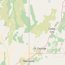
Use this park location map to pinpoint LaVerkin Creek Wilderness in United States of America, understand its exact geographic position, and read its mapped placement within the surrounding landscape more clearly.

Pigeon | © OpenStreetMap contributors

Location context for LaVerkin Creek Wilderness

UtahWashington County
Park atlas

Compare adjacent canyon reserves, watershed corridors, and regional protected lands

Explore Parks Near LaVerkin Creek Wilderness and Surrounding Protected Landscapes

Browsing parks near LaVerkin Creek Wilderness reveals connected canyon terrains, high plateau reserves, and regional watershed protection units across southwestern Utah. Expanding the geographic comparison highlights broader conservation networks and shared geological features throughout the surrounding canyon country.
National parkUtah
About 0.8 km away#1 closest

Southeast

Zion National Park National Park: Detailed Mapped Geography and Protected Landscape Identity

Explore the mapped terrain and regional context of this Utah national park.

Zion National Park represents a key protected area within Utah, ideal for detailed geographic exploration. This canonical page offers insights into the park's specific mapped boundaries, its inherent landscape character, and its regional geographic setting. It is designed for users seeking to understand the atlas-level significance of Zion National Park as a national park entity, focusing on its protected terrain and natural geography.

Area
593.26 km²
Established
1919
IUCN
II
Visitors
4.9M annual
Wildlife reserveUtah
About 52 km away#2 closest

Southwest

Red Mountain Wilderness: Mapped Sandstone Massif and Protected Landscape in Utah

Ecological transitions between the Mojave Desert and Great Basin

Red Mountain Wilderness is a distinct protected landscape in southwestern Utah characterized by its dramatic Navajo sandstone block. Positioned near the Gunlock Fault and Snow Canyon, the area features rugged desert terrain where Mojave and Great Basin ecosystems converge. This wilderness preserves significant archaeological history and diverse plant communities within its sandstone canyons and flats, offering a window into the varied natural environment of the region.

Area
75.8 km²
Established
2009
IUCN
Ib
Relief
Upland
National parkUtah
About 74 km away#3 closest

East

Bryce Canyon National Park: Utah's Mapped Protected Landscape and Geographic Context

Explore the unique geology and protected boundaries of Bryce Canyon National Park.

Bryce Canyon National Park offers a distinct protected landscape within the geography of Utah, characterized by its unique geological formations. This entry provides essential context for understanding its mapped boundaries and natural terrain, serving as a vital component for atlas-based discovery of protected areas. Investigate the specific geographic setting and conservation significance of this iconic national park.

Area
145.02 km²
Established
1928
IUCN
II
Visitors
2.5M annual
A horizontal watercolor illustration showing a calm lake in the foreground, surrounded by grassy banks, evergreen trees, and rolling mountains in the distance under a pale sky.
Protected landscapeArizona
About 77 km away#4 closest

Southeast

Kaibab National Forest: Protected Plateau Landscapes and Forested Geography in Arizona

High-elevation forest terrain bordering the Grand Canyon

Spanning over 1.6 million acres in Arizona, Kaibab National Forest is characterized by its split geographic configuration, with distinct sections flanking the North and South rims of the Grand Canyon. The terrain ranges from the high-altitude Kaibab Plateau to volcanic uplands near Williams, encompassing four designated wilderness areas and varied forest ecosystems that provide a critical buffer for the surrounding canyon country.

Area
6,500 km²
Established
1909
Relief
Mountain
Climate
Temperate
A minimalist watercolor painting depicting a pale desert landscape with soft green hills and light reddish rock formations against a white background.
Wildlife reserveArizona
About 96 km away#5 closest

Southeast

Kanab Creek Wilderness: Protected Canyon Landscapes and Geography of Northern Arizona

Extensive tributary canyon systems and plateau terrain

Kanab Creek Wilderness represents a vast protected area in northern Arizona, defined by deep gorges and vertical cliffs etched into the Kanab and Kaibab Plateaus. This geographic atlas entry provides insights into the canyon network that feeds the Colorado River, highlighting the extreme elevation gradients and archaeological significance of this rugged wilderness.

Area
305 km²
Established
1984
IUCN
Ib
Relief
Upland
Watercolor painting of a forested landscape featuring pine trees and distant rolling mountains on a white background.
Wildlife reserveArizona
About 113 km away#6 closest

South

Mount Trumbull Wilderness: A Detailed Geographic Overview of Northern Arizona Volcanic Protected Lands

Mapping basalt mesas and cinder cone ecosystems on the Uinkaret Plateau

Mount Trumbull Wilderness represents a distinct volcanic protected area located on the Uinkaret Plateau of the Arizona Strip. This rugged wilderness encompasses a massive basalt-capped mesa, scattered cinder cones, and deep ecological gradients ranging from pinyon-juniper woodlands to ancient ponderosa forests, providing a vivid look at the complex geological history near the Colorado River.

Area
31 km²
Established
1984
IUCN
Ib
Relief
Mountain
National parkArizona
About 115 km away#7 closest

Southeast

Grand Canyon National Park: Arizona National Park Protected Landscape & Geography

Explore mapped boundaries and regional atlas context.

Grand Canyon National Park stands as a premier national park, showcasing a unique protected landscape within Arizona's diverse geography. This detailed entry focuses on the park's specific geographic identity, its mapped boundaries, and its significance within the regional atlas. Discover the contours of this protected area and its place in the natural terrain of the American Southwest.

Area
4,926.08 km²
Established
1919
IUCN
II
Visitors
4.9M annual
A horizontal watercolor painting showing a soft-focus landscape with a pale river winding through desert terrain under a hazy sky, with stylized cacti in the foreground.
Protected landscapeUnited States of America
About 137 km away#8 closest

East

Glen Canyon National Recreation Area: Protected Landscape and High Desert Geography Map

Colorado Plateau canyons, sandstone strata, and reservoir environments

Explore the geological architecture of Glen Canyon National Recreation Area, a vast federal protected landscape. The area showcases towering Navajo Sandstone cliffs, deep blue reservoir arms, and remote backcountry canyons that exemplify the distinct high desert terrain of the Colorado Plateau in the United States.

Area
5,075.23 km²
Established
1972
Visitors
5.2M annual
Relief
Upland

Common questions about visiting, size, designation, and location context for LaVerkin Creek Wilderness

LaVerkin Creek Wilderness FAQs for park facts, access, geography, and protected area context

Find quick answers about LaVerkin Creek Wilderness, including protected-area facts, park geography, trail and visitor context, and how the park fits into its surrounding country and regional landscape.
MoriAtlas Explorer

Continue Your Protected Areas Search Across the Global Atlas

Deepen your exploration by continuing the structured search for national parks and protected areas worldwide. Utilize the comprehensive filtering capabilities to compare different conservation landscapes and refine your understanding of global park geography. Discover more about the distribution and characteristics of protected natural areas.

Global natural geography