Mori Atlas logo
Nature reserveLeutratal und Cospoth

Mapped calcareous grasslands and orchid-rich forest terrain in the middle Saale valley

Leutratal und Cospoth Nature Reserve: A Protected Muschelkalk Landscape in Thuringia, Germany

Leutratal und Cospoth represents a pivotal conservation area in Thuringia, characterized by its distinct Muschelkalk limestone geology and asymmetric valley structure. This nature reserve, located near Jena, provides a mosaic of dry calcareous grasslands and beech woodlands that support rare botanical assemblages. Users can trace the boundaries of this ecological corridor and examine how the terrain transitions from the Cospoth plateau to the lush Leutra valley floor.

nature reservecalcareous grasslandorchid habitatbeech forestMuschelkalk landscapedry grassland

Leutratal und Cospoth

Nature reserve

Park overview

Structured park overview, official facts, and landscape profile for Leutratal und Cospoth

Leutratal und Cospoth park facts, protected area profile, and essential visitor context

Review the core facts for Leutratal und Cospoth, including designation, size, terrain, visitor scale, habitats, and operating context in one park-focused overview.

About Leutratal und Cospoth

Leutratal und Cospoth is a nature reserve in Thuringia that combines the wooded valley of the Leutra stream with the slopes, ridges, and plateau surrounding the Cospoth, a 397-meter hill south of Jena. Together, these elements form one of the most ecologically significant Muschelkalk landscapes in the central Saale valley.

The reserve's identity is rooted in its geology. The underlying limestone produces thin, well-drained, calcium-rich soils that favor dry and semi-dry calcareous grasslands, while the slope and valley topography creates a sharp contrast between sun-exposed open slopes and cooler, shaded beech woodland on north-facing aspects and in the valley bottom. This juxtaposition of woodland and open habitat, set against a backdrop of limestone cliffs and ledges, gives the area its characteristically varied and botanically rich appearance.

Beyond the biological importance, the reserve is also a notable landscape conservation success story. For decades, the valley was crossed by the Bundesautobahn 4, whose route was incompatible with the protected status of the area. The decision to reroute the highway through the new Jagdberg Tunnel, completed in 2014, allowed the decommissioning and dismantling of the old road across the valley floor, restoring the ecological continuity of the Leutratal and reopening access to the original spring of the Leutra.

The reserve today is recognized both as a core site in the "Orchideenregion Jena" large-scale conservation project and as a long-established teaching and research landscape. Botanists and mycologists have studied the area since at least the 1930s, and it continues to serve as an excursion and reference site for the study of calcareous grassland ecology in central Germany.

Quick facts and research context for Leutratal und Cospoth

Leutratal und Cospoth is a Thuringian nature reserve classified under IUCN Category IV (Habitat/Species Management Area), with the official German designation number 150. The core Leutratal portion, roughly 141.5 hectares, was first provisionally protected in 1937 and formally designated in 1961.

The reserve was substantially expanded in 2007 under the larger "Orchideenregion Jena" conservation project, reaching its current combined extent of around 582.9 hectares. It lies on the Ilm-Saale and Ohrdrufer Platte, between the Jena districts of Ammerbach, Göschwitz, Leutra, and Winzerla and the Bucha villages of Nennsdorf, Oßmaritz, and Schorba.

A defining modern feature is the rerouting of the A4 autobahn out of the valley: the old highway was decommissioned in 2014 in favor of the new Jagdberg Tunnel alignment, after which the former road corridor was dismantled and renaturalized, restoring continuous habitat across the valley floor.

Protection and recognition

Terrestrial conservation metrics, establishment year, and formal recognition data

Leutratal und Cospoth Protection Status and Designated History Records

Leutratal und Cospoth maintains a documented terrestrial protection scope established in the year 2007. Official records track international recognition data and designation history for advanced conservation research.

Protection details

Protection scope
Terrestrial
Designated year
2007
Transboundary protection
No
WDPA ID
14498
Park context

Deeper park guide and search-rich context for Leutratal und Cospoth

Leutratal und Cospoth history, landscape, wildlife, and travel context

Explore Leutratal und Cospoth through its history, landscape character, ecosystems, wildlife, conservation priorities, cultural context, and seasonal travel timing in a structured park guide built for atlas discovery and search intent.

Why Leutratal und Cospoth stands out

Leutratal und Cospoth is best known for its extensive orchid-rich calcareous grasslands and Orchid-beech forests, growing on the warm, south-facing Muschelkalk slopes of the middle Saale valley. These habitats concentrate a notable diversity of terrestrial orchids and other lime-loving wildflowers within a relatively compact valley-and-plateau setting near Jena. The reserve is also strongly associated with the broader "Orchideenregion Jena" conservation initiative, which connects Leutratal und Cospoth with other Muschelkalk slope reserves in the middle Saale valley. Together, these sites represent one of the most important orchid landscapes in Thuringia and have been the subject of long-term botanical and mycological research dating back to the 1930s.
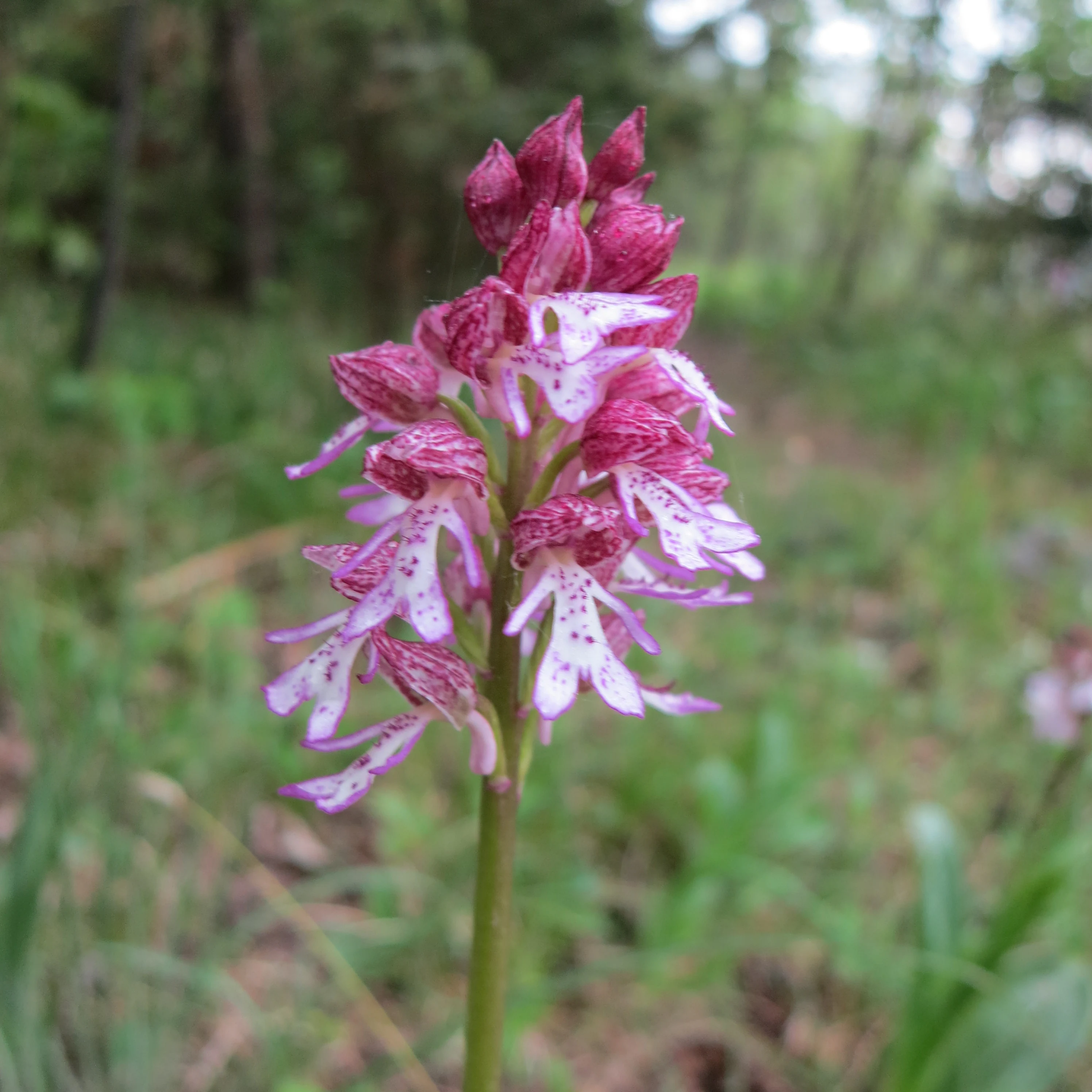
A close-up shot of a purple and white speckled orchid flower blooming in a grassy meadow.
A detailed close-up of a lady orchid in the Leutratal nature reserve.

Leutratal und Cospoth history and protected-area timeline

The origins of the reserve go back to the late 1930s, when a roughly 141.5-hectare portion of the present-day protected area was provisionally designated as the nature reserve "Leutratal" in 1937. This early protection reflected the growing recognition, during that period, of the scientific and conservational value of the Muschelkalk slopes south of Jena and their unusual concentration of orchids and other lime-loving plants.

In 1961, the Leutratal area received formal, definitive protection as a Naturschutzgebiet, placing it among the older nature reserves of the German Democratic Republic and establishing the legal basis for managing the area as a botanical and ecological reference site. Throughout the second half of the twentieth century, the site supported ongoing research into its vascular plants and fungi, including detailed mycofloristic and mykocoenological investigations carried out on the xerothermic habitats of the reserve.

A decisive modernization of the reserve came in 2007 under the Naturschutzgroßprojekt "Orchideenregion Jena – Muschelkalkhänge im Mittleren Saaletal." As part of this larger project, an additional 441.4 hectares were placed under protection, and the reserve was formally renamed Leutratal und Cospoth to reflect both the expanded area around the Cospoth and the renewed focus on the region's orchid-rich habitats.

The most visible recent chapter in the reserve's history is the rerouting of the A4 autobahn. The original highway, built in the 1930s, cut through the valley and stood in direct conflict with the protected status of the Leutratal. In November 2014, traffic was shifted to a new 11.8-kilometer alignment that includes the Jagdberg Tunnel beneath the reserve. Following the closure of the old route, the road surface was removed and the corridor, composed of construction debris, river gravels, and concrete remnants, was renaturalized, with pioneer grasses, foxtails, and mayweed among the first species to recolonize the former roadway.

Leutratal und Cospoth landscape and geographic character

The landscape of Leutratal und Cospoth is defined by a shallow, asymmetric valley cut into the Muschelkalk limestone of the Ilm-Saale and Ohrdrufer Platte. The Leutra stream runs through the valley bottom, while the slopes rise to the relatively flat plateau that culminates in the 397-meter Cospoth. The result is a compact, clearly structured topography that packs a surprising amount of landscape variety into a small area.

Open, south- to west-facing slopes are dominated by dry and semi-dry calcareous grasslands, with thin soils and frequent limestone outcrops that create a warm, sun-exposed microclimate. These open slopes alternate with patches of scrub and woodland, while the valley bottom and cooler, north-facing slopes support denser beech forest and other deciduous woodland types. Where the limestone bedrock is exposed at the surface, the resulting rocky ledges and small cliffs add both visual drama and habitat complexity.

The Cospoth itself forms a modest but prominent plateau-like elevation at the heart of the reserve. Around it, the terrain steps down toward the Leutra valley, producing transitions between open plateau, wooded slope, and valley floor within short distances. This tight interleaving of habitats, set against the geological backdrop of the middle Saale valley, gives the reserve its distinctive combination of openness, woodland, and topographic relief.

Leutratal und Cospoth ecosystems, habitats, and plant life

Ecologically, Leutratal und Cospoth is a textbook example of a Muschelkalk calcareous landscape, in which the chemistry of the underlying limestone shapes the composition of the vegetation. The reserve's protected habitats include extensive dry and semi-dry calcareous grasslands, often rich in orchids, as well as Orchid-beech forests, where characteristic ground flora thrive beneath beech canopy on lime-rich soils.

The combination of open grassland, woodland edge, scrub, and exposed rock supports a high diversity of plant communities within a relatively confined footprint. The reserve's protection goals explicitly emphasize the maintenance of the large-scale orchid-rich dry and semi-dry grasslands and the associated beech forests as a habitat complex for rare plant and animal species, while also safeguarding the area as a significant site for teaching, research, and field excursions.

The rebounding of the former autobahn corridor has added a younger, ruderal element to the ecological mosaic. After the road surface was removed, the remaining substrate of debris, river gravel, and concrete fragments became a substrate for pioneer vegetation, including grasses, foxtails, and mayweed. This early successional stage is gradually being integrated into the wider habitat network of the valley, alongside the older grassland and forest habitats that define the reserve.

Leutratal und Cospoth wildlife and species highlights

Although the reserve is primarily recognized for its botanical richness, the mosaic of dry grassland, woodland, scrub, and rocky habitat also supports a varied invertebrate and small vertebrate fauna typical of warm, calcareous landscapes in central Germany. The combination of exposed slopes and sheltered valleys provides both feeding and shelter opportunities for insects and other organisms associated with these habitats.

The reserve's status as a habitat for rare plant and animal species is explicitly part of its official protection purpose, alongside the conservation of the orchid-rich grasslands and beech forests themselves. The maintained openness of the grasslands and the structural diversity between woodland edge and open ground are key to sustaining this fauna over the long term.

Leutratal und Cospoth conservation status and protection priorities

Conservation significance at Leutratal und Cospoth rests on the preservation of a representative and unusually intact example of Muschelkalk calcareous habitat in the middle Saale valley. The reserve's protection purpose centers on maintaining the large-scale orchid-rich dry and semi-dry grasslands and Orchid-beech forests as continuous habitat for rare plants and animals, while also preserving the site's value as a long-term reference location for teaching and scientific research.

The 2007 expansion and renaming marked a transition from a smaller, older reserve to a larger landscape-scale protection effort integrated into the "Orchideenregion Jena – Muschelkalkhänge im Mittleren Saaletal" conservation project. This project consolidated the protection of calcareous grassland landscapes around Jena and elevated the reserve's role within a broader regional network of Muschelkalk slope reserves.

A second major conservation milestone was the rerouting of the A4 autobahn through the Jagdberg Tunnel and the subsequent dismantling and renaturalization of the old road within the Leutratal. By physically removing a long-standing infrastructure barrier from the valley, the project restored habitat continuity across a key section of the reserve and effectively reconnected grassland, woodland, and the upper course of the Leutra stream.

Leutratal und Cospoth cultural meaning and human context

The reserve is closely bound to the identity of Jena and the surrounding Saale-Holzland region. Its location directly south of the Jena urban area means that the protection of orchids, dry grasslands, and old-growth beech is intertwined with the surrounding tradition of natural history research associated with the university city.

The valley's long history of botanical and mycological study, including detailed mid-twentieth-century research on xerothermic habitats in the former GDR, makes Leutratal und Cospoth part of the regional cultural landscape of science as much as a piece of natural landscape. Local nature guides and excursion traditions, such as those documented in regional nature guides to the Leutratal area, reflect the site's persistent role as a place where local inhabitants, students, and visitors engage directly with the landscape.

Top sights and standout views in Leutratal und Cospoth

The reserve's most distinctive qualities include its large-scale orchid-rich calcareous grasslands on Muschelkalk slopes, its associated Orchid-beech forests, and the recently renaturalized former autobahn corridor that now functions as new habitat within the valley. Together, these features create a reserve that is both ecologically rich and shaped by an unusually direct conservation success story.

Its embeddedness in the "Orchideenregion Jena" large-scale conservation project, and its proximity to one of Thuringia's principal university cities, further reinforce Leutratal und Cospoth's standing as a flagship site for calcareous grassland conservation and research in the central Saale valley.

Best time to visit Leutratal und Cospoth

Late spring and early summer are widely regarded as the most rewarding period for visiting calcareous grassland landscapes of this type, when the majority of terrestrial orchids and many associated wildflowers reach peak bloom on the warm, open slopes. Early summer conditions also tend to offer the clearest views across the mosaic of grassland, woodland, and rocky outcrops that define the reserve.

Late spring through summer is also the season in which the reserve's botanical diversity, including the characteristic Orchid-beech forest ground flora, is most easily appreciated. As with any such protected area, the precise timing of flowering will vary from year to year with weather conditions, and visitors should follow the rules and access guidance in force within the reserve at any given time.


Monthly climate preview

Track monthly temperature variations and precipitation averages across the representative coordinate.

Leutratal und Cospoth Climate Normals: Long Term Temperature and Precipitation Rhythm

Long term climate data for Leutratal und Cospoth records measured monthly temperature fluctuations alongside daily precipitation amounts. Exploring the complete twelve month profile provides granular averages for temperature ranges and seasonal moisture distribution.
Annual mean9 °C
-1 °C19 °C
Jan-1°
Feb
Mar
Apr
May13°
Jun17°
Jul19°
Aug19°
Sep14°
Oct
Nov
Dec
Warmest month
July

18.9 °C

Coolest month
January

-1 °C

Wettest month
July

2.5 mm/day

Driest month
April

1.3 mm/day

Park location guide

Geography guide, regional context, and park location map for Leutratal und Cospoth

Leutratal und Cospoth park geography, regions, and map view in Germany

Understand where Leutratal und Cospoth sits in Germany through a broader geographic reading of the surrounding landscape, nearby location context, and its mapped position within the national park landscape.

How Leutratal und Cospoth fits into Germany

Germany is a federal republic in Western and Central Europe with a population of over 83 million across sixteen constituent states. It is Europe's largest economy by nominal GDP and a major global exporter and importer. The capital is Berlin, and the country borders Denmark, Poland, Czech Republic, Austria, Switzerland, France, Luxembourg, Belgium, and the Netherlands.

Wider geography shaping Leutratal und Cospoth in Germany

Germany is located in Western and Central Europe, spanning 357,022 km². It borders Denmark to the north, Poland and the Czech Republic to the east, Austria and Switzerland to the south, and France, Luxembourg, Belgium, and the Netherlands to the west. The country has coastlines on the Baltic Sea and North Sea to the north, with the Alps located in the southern region.

Map view of Leutratal und Cospoth

Use this park location map to pinpoint Leutratal und Cospoth in Germany, understand its exact geographic position, and read its mapped placement within the surrounding landscape more clearly.

Pigeon | © OpenStreetMap contributors

Location context for Leutratal und Cospoth

Thuringia

Visual reference guide to limestone valley terrain, orchid habitats, and protected woodland environments

Leutratal und Cospoth Landscape Photos and Calcareous Grassland Scenery

Visual documentation captures the limestone valley terrain, open calcareous grasslands, and woodland habitats defining Leutratal und Cospoth. Examining field photographs helps observers understand the topography and ecological character of this protected Thuringian nature reserve.

A close-up shot of a purple and white speckled orchid flower blooming in a grassy meadow.

Park atlas

Compare regional limestone reserves and connected valley landscapes

Parks Near Leutratal und Cospoth and Surrounding Protected Areas

Browse other protected areas near Leutratal und Cospoth to examine similar calcareous grasslands and valley ecosystems across the surrounding region. Expanding the geographic comparison reveals broader conservation networks and related limestone habitats throughout central Thuringia.
A horizontal watercolor illustration showing green rolling hills, distant light green ridges, and sparse trees against a white background.
Nature reserveThuringia
About 2.4 km away#1 closest

Southeast

Spitzenberg-Schießplatz Rothenstein-Borntal Nature Reserve and Saale Valley Geography

Protected forest and grassland terrain in Thuringia

Spitzenberg-Schießplatz Rothenstein-Borntal is a protected nature reserve in Thuringia, covering hundreds of hectares of forest slopes, plateaus, and open clearings. This reserve is recognized for its unusual structural diversity, ranging from closed valley woodland to sun-exposed semi-dry grassland, providing essential habitat within the middle Saale valley region.

Area
5.542 km²
Established
1961
IUCN
IV
A soft watercolor painting of a green landscape with trees, rolling hills, and a body of water under a light sky.
Nature reserveThuringia
About 2.5 km away#2 closest

Northwest

Jenaer Forst Nature Reserve: Mapping the Protected Limestone Plateau and Forest Terrain

Protected nature reserve in Thuringia, Germany

Jenaer Forst is a 540 hectare nature reserve in Thuringia, characterized by dry calcareous woodland and active restoration work. The site is a study in landscape recovery, balancing forest management with the protection of orchid-rich habitats on its limestone plateau. This detailed atlas entry provides insights into the park boundaries, geological features, and ecological significance of this peri-urban forest zone.

Area
5.411 km²
Established
2008
IUCN
IV
Nature reserveThuringia
About 9 km away#3 closest

North

Windknollen Nature Reserve: Mapping Protected Limestone Landscapes in Thuringia

Examining the plateau geography and former training site boundaries

The Windknollen nature reserve occupies a distinct position on the Muschelkalk limestone plateau near Jena. Its protected status reflects an evolution from historical battlefield use to a formal conservation area within the National Natural Heritage framework. The terrain is defined by exposed; dry-adapted vegetation across 185 hectares of highland geography.

Area
1.851 km²
Established
1997
IUCN
IV
Nature reserveWeimarer Land
About 13 km away#4 closest

West

Seeteich Blankenhain Nature Reserve: Geographic Map and Protected Area Context

Wetland landscape situated in the Weimarer Land district

Seeteich Blankenhain is a distinct nature reserve in Germany, characterized by its historic pond and surrounding moist lowland ecosystems. This site remains a focal point for ecological research and conservation, offering a layered landscape of reed zones and woodland that supports a diverse bird community. Its presence within the regional geography of Weimarer Land highlights the importance of small-scale wetland preservation in the Thuringian landscape.

Established
1991
Relief
Lowland
Access
Access unknown
Scope
Terrestrial
Nature reserveThuringia
About 19 km away#5 closest

North

Lohholz Nature Reserve: Protected Forest and Meadow Mosaic in Thuringia

Mapped deciduous woodlands and river valley meadow geography

Lohholz constitutes an isolated nature reserve in Thuringia, showcasing a distinct mosaic of broadleaf forest and traditional orchard meadows. The terrain slopes toward the Saale river valley, featuring varied grassland communities and a vital spring-fed brook. This protected area offers a look at forest preservation within a landscape predominantly utilized for agricultural purposes.

Area
0.304 km²
Established
1995
IUCN
IV
Relief
Upland
Protected landscapeThuringia
About 21 km away#6 closest

West

Landschaftsschutzgebiet Mittleres Ilmtal: Protected Landscape Geography and Map Discovery

Thuringia regional atlas and protected area profile

Gain insight into the diverse topography of Landschaftsschutzgebiet Mittleres Ilmtal, which spans roughly 150 square kilometers. This protected landscape is characterized by its dramatic shifts from Buntsandstein forests in the Tannrodaer Sattel to the elevated Muschelkalk escarpments, offering a detailed case study in German mid mountain geography.

Area
150 km²
Relief
Upland
Climate
Temperate
Access
Access unknown
A soft watercolor painting of a rolling landscape with green hills, scattered trees, and pale, earthy foreground textures.
Nature reserveThuringia
About 21 km away#7 closest

South

Buchenberg bei Krölpa Nature Reserve: Mapped Geography and Protected Landscape Context

A restored limestone quarry habitat located in Thuringia, Germany.

Buchenberg bei Krölpa stands as a regionally significant nature reserve located east of Krölpa. Formerly a site of limestone extraction, the protected area now functions as a managed habitat, characterized by its broken, stepped terrain and slopes that host native orchid species and dry grassland vegetation within the broader Thuringian countryside.

Area
0.201 km²
Established
1996
IUCN
IV
Relief
Upland
Nature reserveThuringia
About 24 km away#8 closest

Northwest

Südhang Ettersberg Nature Reserve: Geographic Overview and Protected Area Boundaries

A prominent protected ridge landscape in central Thuringia

Südhang Ettersberg encompasses 408 hectares of south-facing slopes, creating a unique microclimate in the Weimarer Land district. This nature reserve serves as a benchmark for dry grassland and thermophilic woodland conservation in central Germany, offering a distinct mapped landscape that stands out from the surrounding agricultural lowlands.

Area
4.083 km²
Established
1997
IUCN
IV
Relief
Upland

Common questions about visiting, size, designation, and location context for Leutratal und Cospoth

Leutratal und Cospoth FAQs for park facts, access, geography, and protected area context

Find quick answers about Leutratal und Cospoth, including protected-area facts, park geography, trail and visitor context, and how the park fits into its surrounding country and regional landscape.
MoriAtlas Explorer

Continue Your Protected Areas Search Across the Global Atlas

Deepen your exploration by continuing the structured search for national parks and protected areas worldwide. Utilize the comprehensive filtering capabilities to compare different conservation landscapes and refine your understanding of global park geography. Discover more about the distribution and characteristics of protected natural areas.

Global natural geography