Mori Atlas logo
Nature reserveLippeniederung zwischen Bad Lippspringe und Mastbruch

Examining the riverine floodplain geography and protected meadow habitats along the Lippe river valley.

Lippeniederung zwischen Bad Lippspringe und Mastbruch: Mapped Nature Reserve in Westphalia

(Naturschutzgebiet Lippeniederung zwischen Bad Lippspringe und Mastbruch)

The Lippeniederung zwischen Bad Lippspringe und Mastbruch nature reserve preserves a fragment of the historic floodplain landscape within the Paderborn district. This protected area consists of three distinct parcels that capture the essential riverine terrain, wet meadows, and transitional ecological zones defining this part of the Westphalian landscape in Germany.

nature reservefloodplainriver valleyLippe riverwet meadowshabitat management

Lippeniederung zwischen Bad Lippspringe und Mastbruch

Nature reserve

Park overview

Structured park overview, official facts, and landscape profile for Lippeniederung between Bad Lippspringe and Mastbruch

Lippeniederung between Bad Lippspringe and Mastbruch park facts, protected area profile, and essential visitor context

Review the core facts for Lippeniederung between Bad Lippspringe and Mastbruch, including designation, size, terrain, visitor scale, habitats, and operating context in one park-focused overview.

About Lippeniederung between Bad Lippspringe and Mastbruch

Lippeniederung zwischen Bad Lippspringe und Mastbruch is a designated nature reserve in the central-eastern part of the German state of North Rhine-Westphalia. It lies in the district of Paderborn, occupying a position along the Lippe river between the spa town of Bad Lippspringe and the Mastbruch area, which administratively belongs to the Paderborn district of Schloß Neuhaus.

The reserve is composed of three separate land parcels, reflecting the fragmented nature of the remaining semi-natural landscape in the heavily used Lippe valley. Together they amount to about 159 hectares and follow the lowland course of the Lippe southeast of the centre of Bad Lippspringe. Infrastructure crosses the area on its edges: the federal highway B 1 runs along the western boundary, while the state road L 814 passes through the northern portion of the protected zone.

Designated under the key number PB-046 and recognised in Germany's federal nature conservation system, the area carries the IUCN Category IV status, which designates it as a habitat and species management area. This means that the primary objective of the reserve is the active conservation of particular habitat types and species assemblages associated with the Lippe floodplain rather than the maintenance of an undisturbed wilderness. Its inclusion in the World Database on Protected Areas, under WDPA ID 318739, places it within the international framework of recognised protected sites.

The reserve is part of what the Landschaftsverband Westfalen-Lippe describes as a regionally significant cultural landscape along the Lippe valley, an area where the natural river environment and centuries of human land use have shaped a distinct regional character. The protection designation therefore sits at the intersection of nature conservation and cultural landscape preservation in this part of Westphalia.

Quick facts and research context for Lippeniederung between Bad Lippspringe and Mastbruch

Lippeniederung zwischen Bad Lippspringe und Mastbruch is a nature reserve (Naturschutzgebiet) registered under the key number PB-046 in the Paderborn district of North Rhine-Westphalia, Germany. It covers approximately 159 hectares across three separate parcels stretching along the Lippe river between Bad Lippspringe and the Mastbruch locality of Paderborn. The reserve is classified as an IUCN Category IV area, focused on habitat and species management, and is listed in the World Database on Protected Areas under the WDPA ID 318739. It lies in a landscape region that has been identified by the Landschaftsverband Westfalen-Lippe as a regionally significant cultural landscape along the Lippe valley.

Protection and recognition

Documented terrestrial protection scope, designation year, and official recognition records

Lippeniederung zwischen Bad Lippspringe und Mastbruch Protection Status and Designation History

Lippeniederung zwischen Bad Lippspringe und Mastbruch holds a documented terrestrial protection status established in the designation year 1996. Review the recorded management scope and verifiable administrative data to understand its official standing.

Protection details

Protection scope
Terrestrial
Designated year
1996
Transboundary protection
No
WDPA ID
318739
Park context

Deeper park guide and search-rich context for Lippeniederung between Bad Lippspringe and Mastbruch

Lippeniederung between Bad Lippspringe and Mastbruch history, landscape, wildlife, and travel context

Explore Lippeniederung between Bad Lippspringe and Mastbruch through its history, landscape character, ecosystems, wildlife, conservation priorities, cultural context, and seasonal travel timing in a structured park guide built for atlas discovery and search intent.

Why Lippeniederung between Bad Lippspringe and Mastbruch stands out

The reserve is best known for protecting a representative stretch of the Lippe river floodplain in the eastern Paderborn area, including the riverine and meadow habitats that characterise this part of the Lippe valley in Westphalia.
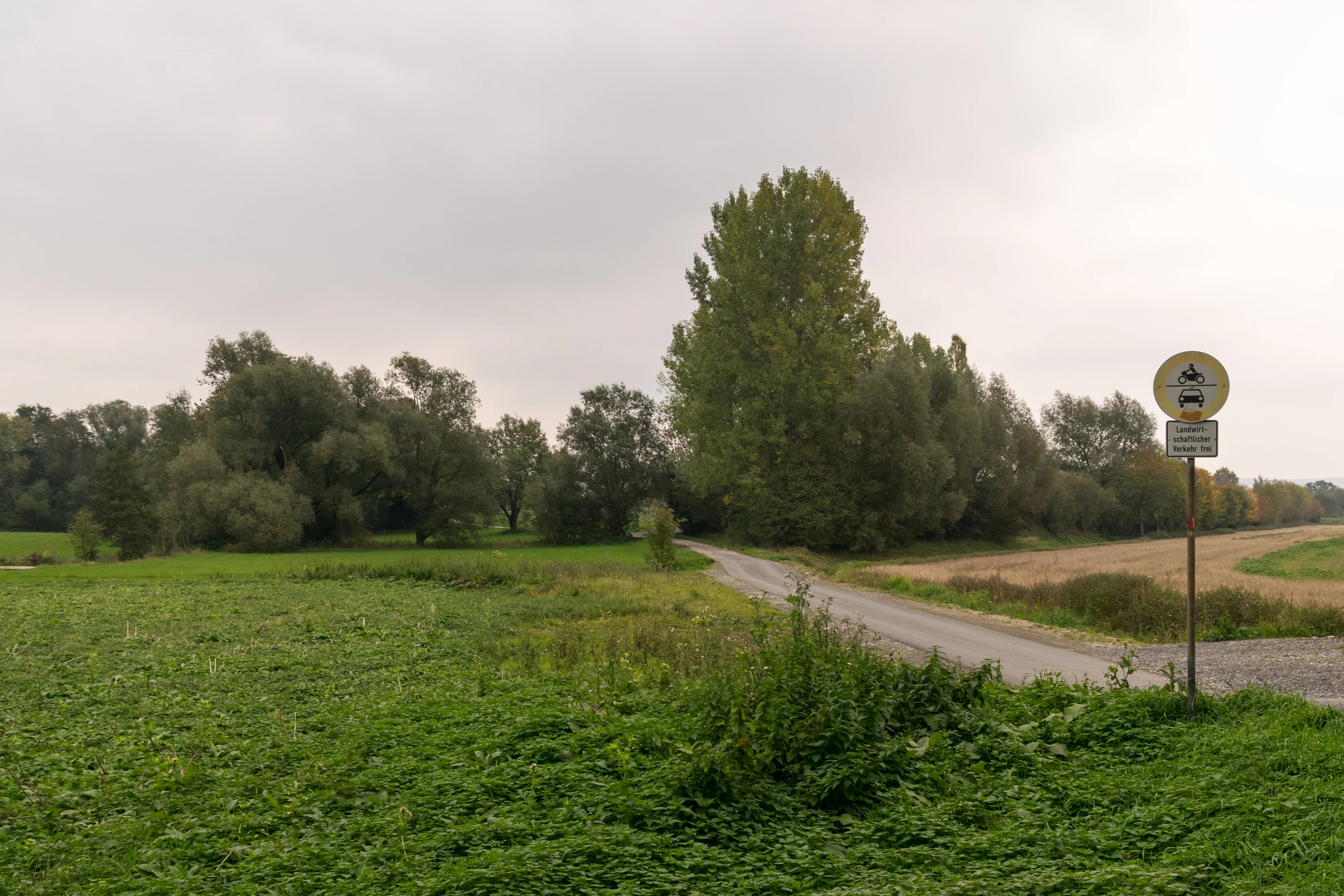
A narrow paved road winds through a flat, green landscape with trees and fields under an overcast sky, with a traffic sign indicating a restricted access zone.
A rural road path through the Lippeniederung nature reserve, marked with vehicle restriction signage.

Lippeniederung between Bad Lippspringe and Mastbruch history and protected-area timeline

The Lippeniederung zwischen Bad Lippspringe und Mastbruch was officially placed under nature protection in 1996 under the key number PB-046, formalising its status as a Naturschutzgebiet within the Paderborn district. Records also note administrative updates associated with the year 2007, suggesting a modernisation or revision of the reserve's designation framework alongside its original 1996 protection order.

Beyond these formal dates, the landscape itself reflects a much longer history of human use of the Lippe valley. The surrounding area has long been shaped by farming, settlement, and infrastructure development, and the surviving floodplain fragments preserved within the reserve represent what remains of the historically more extensive natural riverine environment of this part of Westphalia. The site's inclusion in the regional cultural landscape inventory by the Landschaftsverband Westfalen-Lippe further underlines the long-term significance of the area as a piece of the historic Lippe valley landscape.

Lippeniederung between Bad Lippspringe and Mastbruch landscape and geographic character

The landscape protected by the reserve consists of the low-lying floodplain of the Lippe river as it flows through the eastern part of the Paderborn district. Topographically, the area is flat and shaped by the course of the river, with the characteristic features of a riverine lowland: meadows, wet ground, and transitional zones between water and adjacent farmland.

The protected area is not a single contiguous block but a set of three separate parcels arranged along the river. This fragmentation reflects the broader pattern of the Lippe valley here, where agricultural use and transport corridors have long broken up what would once have been a more continuous floodplain environment. Two notable transport corridors flank or cross the reserve: the federal highway B 1 to the west, and the state road L 814 to the north.

The wider setting combines elements of open countryside with proximity to the town of Bad Lippspringe and the outskirts of Paderborn, including the Schloß Neuhaus district to which the Mastbruch locality belongs. The atmosphere of the area is therefore that of a rural river landscape in close reach of an urban region, a balance that the protection designation seeks to maintain against further development pressure.

Lippeniederung between Bad Lippspringe and Mastbruch ecosystems, habitats, and plant life

The nature of the reserve is closely tied to the ecology of the Lippe floodplain. Although the available documentation does not specify individual species or habitat types in detail, the area's location along a lowland river and its IUCN Category IV classification indicate that its ecological value rests on characteristic floodplain habitat complexes rather than on rare or exceptional species alone.

Such floodplain environments in this part of Westphalia typically support a mosaic of wet meadows, reed beds, alluvial woodland fragments, and aquatic edge habitats along the river. The protection framework is designed to maintain these structural elements of the riverine landscape, which together form the ecological basis of the Lippe valley as a coherent natural system.

The reserve's value lies in holding together, even in a fragmented form, a stretch of this mosaic in an otherwise heavily used valley. The three parcels function as stepping stones of floodplain habitat within the wider Lippe corridor, contributing to the ecological continuity that riverine habitats require to remain viable over time.

Lippeniederung between Bad Lippspringe and Mastbruch conservation status and protection priorities

Lippeniederung zwischen Bad Lippspringe und Mastbruch has been formally protected as a Naturschutzgebiet since 1996 under the key number PB-046, anchoring it within Germany's national nature conservation framework. Its classification as an IUCN Category IV area highlights its role as a habitat and species management area, a designation applied where active management is needed to maintain specific ecological values.

The reserve's conservation role is to preserve a functioning fragment of the Lippe river floodplain in a region where such habitats have been substantially reduced by agricultural intensification and infrastructure development. By holding three parcels under protection, the designation safeguards both the river's immediate surroundings and connecting landscape elements that support the broader ecological coherence of the valley.

Recognition of the reserve internationally through the World Database on Protected Areas under WDPA ID 318739 connects this local protection effort to the global system of monitoring protected areas, while its identification as a regionally significant cultural landscape by the Landschaftsverband Westfalen-Lippe adds a complementary cultural dimension to its conservation significance, linking habitat protection with the preservation of the historic Lippe valley landscape.

Lippeniederung between Bad Lippspringe and Mastbruch cultural meaning and human context

The reserve sits within a stretch of the Lippe valley that has been recognised by the Landschaftsverband Westfalen-Lippe as a regionally significant cultural landscape. This designation, applied under the regional inventory to the area known as Lippetal mit Klusheide und Füllers Heide bis Marienloh, acknowledges the long-standing relationship between the Lippe river, the surrounding agricultural land, and settlements such as Bad Lippspringe, Mastbruch, and Marienloh.

The cultural context of the area is therefore not one of dramatic historical monuments but of an evolved rural landscape in which centuries of human use have shaped the floodplain environment. The nature reserve preserves a portion of this landscape at a moment when its natural elements would otherwise be vulnerable to further loss, while the broader cultural landscape recognition protects the understanding of the area as a coherent cultural and natural entity.

Top sights and standout views in Lippeniederung between Bad Lippspringe and Mastbruch

A compact but ecologically focused floodplain reserve along the Lippe river, the area illustrates how small-scale protected sites contribute to maintaining habitat continuity within an intensively used German lowland river valley.

The combination of nature reserve status with cultural landscape recognition makes the site an example of integrated landscape protection in Westphalia, where habitat conservation and regional cultural heritage are managed in parallel rather than in isolation.

Best time to visit Lippeniederung between Bad Lippspringe and Mastbruch

The Lippe floodplain is most visually and ecologically expressive during the warmer months, when meadow vegetation is in growth and the riverine landscape is at its most active. Late spring and summer typically offer the best conditions for observing the open character of the floodplain, while autumn can highlight seasonal changes in vegetation and water levels along the Lippe.


Monthly climate preview

Long-term representative point measurements for annual temperature and precipitation rhythm

Lippeniederung zwischen Bad Lippspringe und Mastbruch Climate and Temperature Normals

Representative coordinates record measured monthly temperature ranges and steady precipitation averages across the protected terrain. Analyzing twelve-month climatology data provides a clear baseline for tracking long-term environmental patterns in this region.
Annual mean9 °C
1 °C18 °C
Jan
Feb
Mar
Apr
May13°
Jun16°
Jul18°
Aug18°
Sep14°
Oct
Nov
Dec
Warmest month
July

18.1 °C

Coolest month
January

0.5 °C

Wettest month
December

2.6 mm/day

Driest month
April

1.6 mm/day

Park location guide

Geography guide, regional context, and park location map for Lippeniederung between Bad Lippspringe and Mastbruch

Lippeniederung between Bad Lippspringe and Mastbruch park geography, regions, and map view in Germany

Understand where Lippeniederung between Bad Lippspringe and Mastbruch sits in Germany through a broader geographic reading of the surrounding landscape, nearby location context, and its mapped position within the national park landscape.

How Lippeniederung between Bad Lippspringe and Mastbruch fits into Germany

Germany is a federal republic in Western and Central Europe with a population of over 83 million across sixteen constituent states. It is Europe's largest economy by nominal GDP and a major global exporter and importer. The capital is Berlin, and the country borders Denmark, Poland, Czech Republic, Austria, Switzerland, France, Luxembourg, Belgium, and the Netherlands.

Wider geography shaping Lippeniederung between Bad Lippspringe and Mastbruch in Germany

Germany is located in Western and Central Europe, spanning 357,022 km². It borders Denmark to the north, Poland and the Czech Republic to the east, Austria and Switzerland to the south, and France, Luxembourg, Belgium, and the Netherlands to the west. The country has coastlines on the Baltic Sea and North Sea to the north, with the Alps located in the southern region.

Map view of Lippeniederung between Bad Lippspringe and Mastbruch

Use this park location map to pinpoint Lippeniederung between Bad Lippspringe and Mastbruch in Germany, understand its exact geographic position, and read its mapped placement within the surrounding landscape more clearly.

Pigeon | © OpenStreetMap contributors

Location context for Lippeniederung between Bad Lippspringe and Mastbruch

Nordrhein-Westfalen

Explore floodplain terrain, riverine habitats, and wetland scenery across the protected Westphalian valley.

Visualizing Lippeniederung zwischen Bad Lippspringe und Mastbruch Photos and Protected Landscapes

Visual records illustrate the flat lowland floodplain terrain and distinct riverine meadow systems preserved along the Lippe river corridor. Photographic documentation reveals the habitat structure and landscape character of each protected parcel within the Paderborn district.

A narrow paved road winds through a flat, green landscape with trees and fields under an overcast sky, with a traffic sign indicating a restricted access zone.

Park atlas

Explore surrounding river valleys and protected landscapes in the region

Parks Near Lippeniederung zwischen Bad Lippspringe und Mastbruch

Compare Lippeniederung zwischen Bad Lippspringe und Mastbruch with other protected river valley habitats and lowland reserves across the surrounding district. Analyzing adjacent lowland nature reserves provides deeper context into regional floodplain conservation and Westphalian wetland ecosystems.
A watercolor painting showing a green landscape with a winding river and distant hills under a light pink sky.
Protected landscapeKreis Paderborn
About 4.1 km away#1 closest

Southwest

Landschaftsschutzgebiet Fließgewässer und Auen: Regional Protected Landscape Overview

Riverine floodplain corridors and valley habitats in Paderborn

This protected landscape in Kreis Paderborn sustains essential habitat connectivity along river valleys including the Lippe and Beke. Its design features a fragmented network of sixteen sub-areas, showcasing how floodplain vegetation, wet meadows, and riparian corridors function within an urban-adjacent environment.

Area
9.583 km²
Established
1999
Relief
Lowland
Scope
Terrestrial
Nature reservePaderborn
About 9.4 km away#2 closest

Southwest

Ziegenberg Nature Reserve: Protected Landscape Geography and Paderborn River Corridors

Mapping the forest ridges and floodplains of Paderborn district.

Discover the geographic composition of Ziegenberg, a nature reserve in Paderborn that blends riparian meadows with stony forest ridges. This protected site demonstrates the complex relationship between municipal expansion, river hydrology, and conservation within the German landscape.

Area
0.81 km²
Established
1980
Relief
Upland
Climate
Temperate
Nature reserveNorth Rhine-Westphalia
About 10 km away#3 closest

Southwest

Ziegenberg Nature Reserve: Geographic Overview and Protected Area Boundaries

Riparian landscapes and calcareous slopes in the Paderborn region

Ziegenberg offers a distinct look at the intersection of calcareous hillside forests and moist stream environments in Germany. The reserve protects a concentrated diversity of habitats ranging from orchid-rich woodland to alluvial streamside corridors, serving as an important ecological link within the Paderborn district's natural geography.

Area
0.028 km²
Established
1984
IUCN
IV
A soft watercolor illustration featuring rolling green hills, a small grouping of trees on the right, and open grassy terrain on a white background.
Protected areaNordrhein-Westfalen
About 11 km away#4 closest

North

Senne mit Teutoburger Wald: Protected Habitat and Regional Geography Atlas

Heathland and forest ecosystems in North Rhine-Westphalia

This protected area presents a unique geographic profile, merging expansive lowland heath and dune systems with the wooded slopes of the Teutoburg Forest. Its distinct ecological gradient and significant size make it a critical site for habitat conservation, bird protection, and study of transition zones between sandy plains and mountain ridges.

Area
153.597 km²
Established
2001
Relief
Mixed relief
Climate
Temperate
Protected landscapeKreis Paderborn
About 12 km away#5 closest

West

Landschaftsschutzgebiet Delbrücker Rücken Protected Landscape Map and Regional Context

A rural ridge mosaic in the Kreis Paderborn district

This protected landscape in the Kreis Paderborn district features a characteristic mix of deciduous forests, field hedgerows, and agricultural zones on a gentle Westphalian ridge. Its geographic layout provides a clear example of rural land protection integrated into the local environmental buffer system, showcasing a distinct mosaic of terrain that stretches across the lands north and east of Delbrück.

Area
16.1 km²
Established
1970
Relief
Lowland
Climate
Temperate
Nature reserveNorth Rhine-Westphalia
About 13 km away#6 closest

Northeast

Hohlsteinhöhle Nature Reserve: Karst Geography and Subterranean Habitat Maps in North Rhine-Westphalia

Protected limestone fissure caves in the Eggegebirge range

Hohlsteinhöhle stands as a significant protected site within the northern Eggegebirge uplands. Known for its distinct Upper Cretaceous marl-limestone fissures and role as a crucial winter refuge for sensitive bat species, this nature reserve offers a detailed look at the karst-driven geological character of the region, emphasizing the conservation of restricted subterranean environments.

Relief
Mountain
Climate
Temperate
Access
Highly restricted
Scope
Terrestrial
A horizontal watercolor painting depicting a soft-toned landscape with scattered evergreen trees and undulating, sandy terrain under a light sky.
Nature reserveNordrhein-Westfalen
About 13 km away#7 closest

Northwest

Moosheide Nature Reserve: Mapping the Ancient Inland Dune Landscapes of Nordrhein-Westfalen

Protected heathland and spring-fed habitat geography.

Moosheide provides a focused look at the geomorphology of the western Senne region. This reserve protects some of the oldest inland dunes in northwestern Germany, alongside a rare juxtaposition of dry sandy grasslands and groundwater-dependent stream valleys that support high species diversity.

Area
4.427 km²
Established
1994
IUCN
IV
Relief
Lowland
A soft, horizontal watercolor painting showing a winding stream flowing through a green valley with gentle hills and trees in the background.
Nature reserveNordrhein-Westfalen
About 14 km away#8 closest

Southeast

Naturschutzgebiet Schmittwassertal: A Protected Nature Reserve in the Paderborn District

Mapping brook corridors and calcareous grassland landscapes in Westphalia.

Naturschutzgebiet Schmittwassertal represents a fragmented yet ecologically vital nature reserve in Nordrhein-Westfalen. The area encompasses 53.6 hectares of stream-cut valleys and limestone-influenced slopes. This atlas entry details the mosaic of habitats ranging from alder-lined brook corridors to nutrient-poor Borstgrasrasen and semi-dry calcareous grasslands, highlighting its function as a connected biological corridor.

Area
0.536 km²
Established
2014
Relief
Upland
Climate
Temperate

Common questions about visiting, size, designation, and location context for Lippeniederung between Bad Lippspringe and Mastbruch

Lippeniederung between Bad Lippspringe and Mastbruch FAQs for park facts, access, geography, and protected area context

Find quick answers about Lippeniederung between Bad Lippspringe and Mastbruch, including protected-area facts, park geography, trail and visitor context, and how the park fits into its surrounding country and regional landscape.
MoriAtlas Explorer

Continue Your Protected Areas Search Across the Global Atlas

Deepen your exploration by continuing the structured search for national parks and protected areas worldwide. Utilize the comprehensive filtering capabilities to compare different conservation landscapes and refine your understanding of global park geography. Discover more about the distribution and characteristics of protected natural areas.

Global natural geography