Mori Atlas logo
Marine protected areaLoch Alsh Nature Conservation Marine Protected Area

A detailed geographic look at the protected sea loch, flame shell reefs, and ancient coastal terrain.

Loch Alsh Nature Conservation Marine Protected Area: Mapping Highland Marine Landscapes

Loch Alsh Nature Conservation Marine Protected Area occupies a critical coastal corridor between the Isle of Skye and the Scottish mainland. This protected sea loch is defined by its deep glacial history, complex geological setting where ancient Precambrian gneiss meets volcanic formations, and the expansive flame shell colonies on the seabed. The site serves as a vital marine conservation zone, reflecting the convergence of unique underwater biodiversity and the rugged, mountain-framed geography of the Northwest Highlands.

marine protected areasea lochflame shell reefNorthwest HighlandsWester RossInner Hebrides

Loch Alsh Nature Conservation Marine Protected Area

Marine protected area

Park overview

Structured park overview, official facts, and landscape profile for Loch Alsh Nature Conservation Marine Protected Area

Loch Alsh Nature Conservation Marine Protected Area park facts, protected area profile, and essential visitor context

Review the core facts for Loch Alsh Nature Conservation Marine Protected Area, including designation, size, terrain, visitor scale, habitats, and operating context in one park-focused overview.

About Loch Alsh Nature Conservation Marine Protected Area

Loch Alsh is a sea loch carved into the northwestern edge of the Scottish Highlands, separating the Isle of Skye from the mainland coast of Wester Ross. Although modest in size, the loch occupies a particularly distinctive corner of Highland geography, framed to the north by rolling hills like Auchtertyre Hill and Sgurr Mor, and to the south by the steep ascent of Sgurr na Coinnich on Skye, which rises to 739 metres.

Anchored at its eastern end by the village of Kyle of Lochalsh, the loch extends inland for around 12 kilometres, where it branches into the fjord-like sea lochs Loch Duich and Loch Long. Together, these arms give the broader Lochalsh district its deeply indented coastline and its reputation for scenic seascapes. The historic Skye Bridge spans the narrows at Kyle of Lochalsh, a long-standing crossing point between the mainland and the island.

The protected status of Loch Alsh rests on its marine biological importance rather than its terrestrial scenery alone. Underwater surveys of the seabed revealed a flame shell colony of exceptional size, transforming the loch into one of Britain's most significant marine wildlife sites and prompting its inclusion in a Nature Conservation Marine Protected Area. This combination of rugged Highland landscape, intertwined sea lochs, and nationally important marine biodiversity defines the contemporary identity of the Loch Alsh protected area.

Quick facts and research context for Loch Alsh Nature Conservation Marine Protected Area

Loch Alsh lies in Wester Ross within the Highland Region of Scotland, forming a sea loch roughly 12 kilometres long and around 2.5 kilometres wide between the Isle of Skye and the Northwest Highlands mainland. The surrounding region, also known as Lochalsh, is administered as part of Highland council area and borders the Inner Sound to the west.

The protected status of the area rests on a marine survey by Marine Scotland and Heriot-Watt University that revealed one of the largest known flame shell reefs in the United Kingdom, consisting of more than 100 million individuals across roughly 75 hectares of seabed. Protection took effect in 2014 under Scotland's Nature Conservation Marine Protected Area framework.

Protection and recognition

Documented marine protection status, designation history, and management scope

Loch Alsh Nature Conservation Marine Protected Area Protection Status

Loch Alsh Nature Conservation Marine Protected Area holds a documented marine protection status established in 2014. Verified governance records outline its official designation history and management scope without external recognition sources.

Protection details

Protection scope
Marine
Designated year
2014
Transboundary protection
No
Park context

Deeper park guide and search-rich context for Loch Alsh Nature Conservation Marine Protected Area

Loch Alsh Nature Conservation Marine Protected Area history, landscape, wildlife, and travel context

Explore Loch Alsh Nature Conservation Marine Protected Area through its history, landscape character, ecosystems, wildlife, conservation priorities, cultural context, and seasonal travel timing in a structured park guide built for atlas discovery and search intent.

Why Loch Alsh Nature Conservation Marine Protected Area stands out

Loch Alsh is best known for its extraordinary marine wildlife, specifically a vast colony of flame shells, a rare bivalve mollusc that forms living reefs of interwoven shells on the seabed. The 2012 discovery of a reef of over 100 million flame shells covering about 75 hectares made Loch Alsh the most important known site for this species in the UK and triggered its formal designation as a Nature Conservation Marine Protected Area in 2014. The loch is also recognised for its dramatic Highland setting between the Inner Hebrides and the mainland, where ancient Precambrian gneiss meets some of the youngest volcanic rocks in western Scotland, including the gabbro and granite formations of Skye.
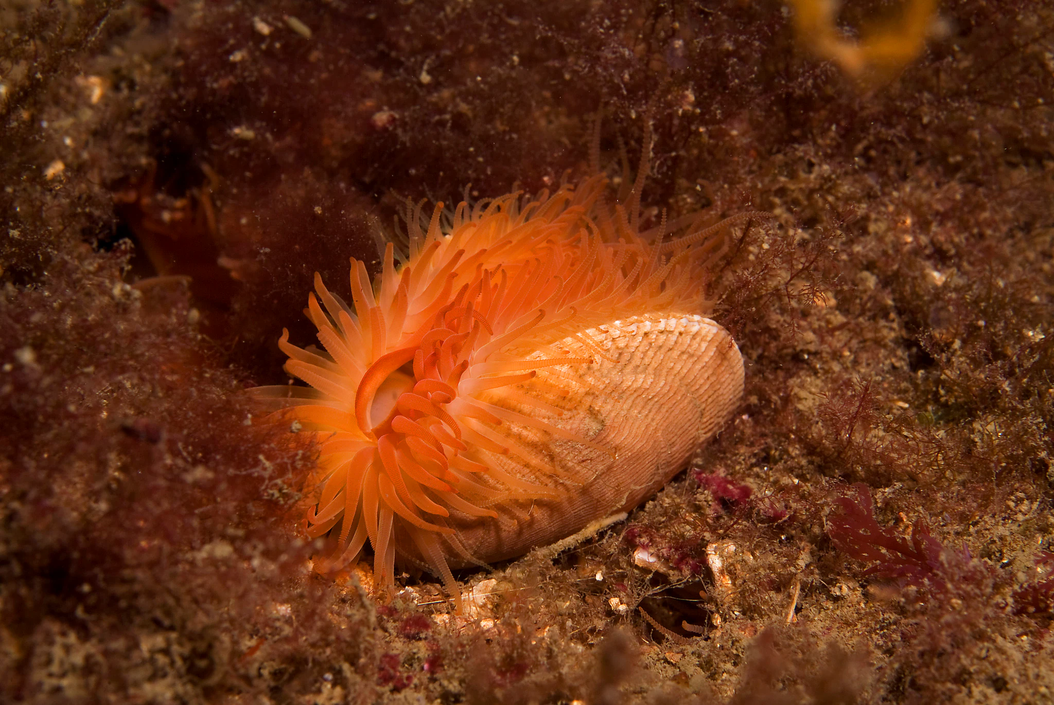
A close-up underwater view of a flame shell showing its vibrant orange tentacles extending from its shell on a sandy, sediment-rich seabed.
A flame shell, a bivalve mollusk known for its bright orange tentacles, resting on the seabed.

Loch Alsh Nature Conservation Marine Protected Area history and protected-area timeline

The human history of the Loch Alsh area stretches back centuries. The name Loch Alsh itself, derived from the Scottish Gaelic Loch Aillse, has long been used not only for the inlet but also for the surrounding country and the feudal holdings associated with it.

In 1719, Loch Alsh was the site of the last invasion of the United Kingdom by Spanish forces, an event that gives the area a notable place in British military history. Beyond this dramatic episode, the broader Lochalsh region was home to crofting communities whose small farms once extended into areas that had previously carried woodland, before the Highland Clearances reshaped rural land use, leaving much of the former croft land as pasture and moor.

The modern conservation significance of the loch began in 2012, when a Marine Scotland-commissioned survey by Heriot-Watt University identified a colossal reef of flame shells on the seabed. Recognising the importance of this habitat, Scottish authorities designated Loch Alsh as a Nature Conservation Marine Protected Area, formally taking effect in 2014.

Loch Alsh Nature Conservation Marine Protected Area landscape and geographic character

Loch Alsh sits within a landscape shaped by extreme geological antiquity and deep glacial carving. The hills enclosing the loch are largely composed of Lewisian gneiss, metamorphic rocks of Precambrian origin that formed roughly 2.8 billion years ago and rank among the oldest exposed rocks in the world. Over billions of years these ancient rocks have been heavily eroded, most recently by successive ice ages that helped sculpt the modern coastline.

Geologically, the loch occupies a critical position just east of the Moine Thrust Belt, a diagonal structure running from the Sleat peninsula northeast to Loch Eriboll. In 1907, local studies of this thrust helped confirm that younger rocks could lie beneath older ones, a finding that contributed to modern theories of mountain building. To the south, across the loch, the gabbro and granite of Skye represent much younger volcanic origins, providing a sharp geological contrast.

Above the waterline, the country around Loch Alsh is hilly but not extreme. Mainland summits such as Auchtertyre Hill at 452 metres and Sgurr Mor at 344 metres frame the northern edge, while Skyside peaks like Sgurr na Coinnich rise more dramatically across the narrows. Moorland dominates the uplands, with lower ground carrying pasture and lowland forest, creating a varied terrain of open views and sheltered glens.

Loch Alsh Nature Conservation Marine Protected Area ecosystems, habitats, and plant life

The natural character of Loch Alsh is defined by the interplay between a wet, oceanic Highland climate, ancient rocky terrain, and the marine ecosystems of the sea loch. Annual rainfall is high, around 2,300 millimetres per year, and temperatures remain mild year-round, with summer highs typically in the mid to high teens Celsius and winter temperatures rarely falling far below freezing. Rain is more likely than not on any given day.

Vegetation follows both the climate and the long history of human land use. Much of the surrounding country is open moorland and pasture, but pockets of native woodland survive, including lowland birchwoods and oakwoods, alongside some conifer plantations. Historically, woodland would have been more extensive before early inhabitants cleared parts of the land for crofting, with later clearance periods expanding pasture at the expense of forest.

Beneath the surface, Loch Alsh holds one of the most distinctive marine habitats in Scotland: an extensive flame shell reef that turns parts of the seabed into a dense, living biogenic structure.

Loch Alsh Nature Conservation Marine Protected Area wildlife and species highlights

The defining wildlife feature of Loch Alsh is its colony of flame shells, a bivalve mollusc whose individuals cement themselves together to form extensive reef-like aggregations on the seabed. The 2012 survey by Marine Scotland and Heriot-Watt University identified a reef consisting of over 100 million flame shells covering about 75 hectares, making it the largest known flame shell reef in the United Kingdom and one of the most significant of its kind in Europe.

The discovery was central to the loch's later protection as a marine conservation site. By preserving the seabed conditions that sustain the reef, the protected area safeguards not only the flame shells themselves but also the broader community of marine life that depends on this rare reef habitat. The surrounding terrestrial environment also supports typical Highland fauna across the moorland, pasture, and surviving woodland habitats that extend inland from the loch.

Loch Alsh Nature Conservation Marine Protected Area conservation status and protection priorities

Loch Alsh's conservation significance is rooted almost entirely in its marine ecology. The 2012 finding of a 75-hectare flame shell reef, an exceptionally rare biotope within British waters, underscored the importance of protecting Loch Alsh's seabed from disturbance. In response, Scottish authorities established a Nature Conservation Marine Protected Area covering the loch, with formal protection taking effect in 2014.

This designation places the loch within a wider framework of Scottish Marine Protected Areas, recognised for habitat features of national importance. The protected status aims to conserve the structure and condition of the seabed, ensuring that the flame shell colony, along with associated marine life, continues to thrive in an environment that combines nutrient-rich Highland waters with stable seabed conditions.

Loch Alsh Nature Conservation Marine Protected Area cultural meaning and human context

The Lochalsh area carries a rich Gaelic and Highland heritage. Its Gaelic name, Loch Aillse, reflects a long linguistic tradition tied to the sea lochs and the families who historically held land around them. Communities such as Kyle of Lochalsh, Ardelve, and Balmacara line the shores of the loch and form the cultural heart of the district.

The area's history includes both the dramatic and the everyday. The failed Spanish landing of 1719 is a well-known event in local lore, and earlier crofting communities shaped the rural landscape for generations. The later effects of the Highland Clearances left a lasting imprint on land use and settlement patterns, with former croft land converted to pasture, shaping the open character of the modern countryside.

Top sights and standout views in Loch Alsh Nature Conservation Marine Protected Area

The standout feature of Loch Alsh is its flame shell reef, a marine structure of over 100 million individuals across 75 hectares that has no equal anywhere else in the United Kingdom. This discovery turned the loch into a nationally important marine conservation site and is the reason the protected area exists today.

Equally striking is the surrounding scenery, where ancient Lewisian gneiss meets the younger volcanic rocks of Skye across a narrow, fjord-like sea loch. The combination of a protected seabed, steep Highland hills, and a tightly woven network of sea lochs makes Loch Alsh a place where marine biodiversity and classical Highland landscape converge in a single setting.

Best time to visit Loch Alsh Nature Conservation Marine Protected Area

Loch Alsh's climate is mild and wet throughout the year, so visitors should expect rain at any season. Summer, from late May through August, brings the warmest temperatures, with daytime highs often reaching between 10 and 18 °C, and the longest daylight hours for exploring the coastline and surrounding hills. This is also when the surrounding pasture and woodland are at their most lush, and seabird and marine wildlife viewing along the loch are most active.

Late spring offers blooming vegetation and relatively quiet conditions before peak tourist traffic, while autumn can bring dramatic skies, shifting light, and a quieter atmosphere around Kyle of Lochalsh. Winter visits are possible but colder, wetter, and shorter in daylight, though they offer striking storm light across the loch and surrounding peaks.

Monthly climate preview

Long-term representative temperature and precipitation patterns across twelve monthly periods

Loch Alsh Nature Conservation Marine Protected Area Climate Normals And Weather By Month

Loch Alsh Nature Conservation Marine Protected Area tracks measured monthly temperature and precipitation normals derived from long-term representative coordinate records. Accessing the complete twelve-month profile provides detailed annual data for comparing long-term average conditions.
Annual mean7 °C
3 °C13 °C
Jan
Feb
Mar
Apr
May
Jun11°
Jul13°
Aug13°
Sep11°
Oct
Nov
Dec
Warmest month
July

12.7 °C

Coolest month
February

3.2 °C

Wettest month
January

5.8 mm/day

Driest month
May

3.3 mm/day

Park location guide

Geography guide, regional context, and park location map for Loch Alsh Nature Conservation Marine Protected Area

Loch Alsh Nature Conservation Marine Protected Area park geography, regions, and map view in United Kingdom

Understand where Loch Alsh Nature Conservation Marine Protected Area sits in United Kingdom through a broader geographic reading of the surrounding landscape, nearby location context, and its mapped position within the national park landscape.

How Loch Alsh Nature Conservation Marine Protected Area fits into United Kingdom

The United Kingdom is a parliamentary constitutional monarchy located in northwestern Europe, consisting of four constituent countries: England, Scotland, Wales, and Northern Ireland. As a major global power with over 69 million residents, it maintains significant international influence in politics, economics, and culture.

Wider geography shaping Loch Alsh Nature Conservation Marine Protected Area in United Kingdom

The United Kingdom is an island nation located in northwestern Europe, surrounded by the Atlantic Ocean, North Sea, English Channel, Celtic Sea, and Irish Sea. It shares a land border with the Republic of Ireland to the west. The territory includes the island of Great Britain, the northeastern portion of Ireland, and most of the smaller British Isles islands.

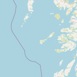
Map view of Loch Alsh Nature Conservation Marine Protected Area

Use this park location map to pinpoint Loch Alsh Nature Conservation Marine Protected Area in United Kingdom, understand its exact geographic position, and read its mapped placement within the surrounding landscape more clearly.

Pigeon | © OpenStreetMap contributors

Location context for Loch Alsh Nature Conservation Marine Protected Area

HighlandScotland

Visualizing the dramatic Highland terrain, sea loch habitats, and protected marine landscapes.

Loch Alsh Nature Conservation Marine Protected Area Photos and Scenery

Examinations of Loch Alsh Nature Conservation Marine Protected Area imagery reveal the complex interplay between ancient geological formations and rare benthic habitats. Visual records document the rugged Northwest Highlands coastline, providing essential context for understanding the marine protected area environment.

A close-up underwater view of a flame shell showing its vibrant orange tentacles extending from its shell on a sandy, sediment-rich seabed.

Park atlas

Compare nearby marine reserves and protected landscapes across the Scottish Highlands.

Other Parks Near Loch Alsh Nature Conservation Marine Protected Area and Surrounding Region

Browsing other parks near Loch Alsh Nature Conservation Marine Protected Area reveals connected marine habitats and rugged coastal terrain across the surrounding region. Extending the geographic comparison helps place local conservation sites within a wider network of protected Scottish landscapes.
A soft, impressionistic watercolor painting of a Scottish loch surrounded by rolling green hills and distant mountain silhouettes.
Marine protected areaRoss and Cromarty
About 14 km away#1 closest

Northeast

Loch Carron Marine Protected Area: Coastal Geography and Protected Seabed Landscape Atlas

Exploring the tidal basins and underwater terrain of Ross and Cromarty.

Loch Carron stands as a landmark marine protected area defined by its dramatic underwater depth changes and robust tidal currents. This protected sea loch features the world's largest flame shell colony nestled beneath the cliffs at Strome Castle. The surrounding Highland geography of Ross and Cromarty creates a compressed, mountain-framed landscape that influences the rich ecological character of this essential coastal habitat.

Area
23 km²
Established
2019
Relief
Lowland
Climate
Temperate
Watercolor painting of a coastal landscape with distant mountains, a rocky shoreline, and light foreground vegetation on a white background.
Protected landscapeHighland
About 50 km away#2 closest

Southwest

Small Isles Protected Landscape: Atlas of the Highland Inner Hebrides Archipelago

Mapped terrain, volcanic geology, and coastal protected areas.

Delve into the geography of the Small Isles, a protected landscape encompassing Rùm, Eigg, Canna, and Muck. This atlas entry provides a structured look at the volcanic peaks, maritime skerries, and diverse land-stewardship boundaries that define this remote Scottish archipelago.

Area
472.35 km²
Established
1981
Relief
Mountain
Climate
Temperate
Protected landscapeHighland
About 51 km away#3 closest

Northeast

Wester Ross National Scenic Area: Protected Highland Mountain and Coastal Landscape Atlas

Geographic mapping of the Northwest Highlands terrain

Wester Ross National Scenic Area spans vast stretches of the Northwest Highlands, characterized by towering Torridonian sandstone peaks and deeply carved sea lochs. This protected region integrates ancient Scots pine forests, glacial-carved glens, and complex coastal environments into one of the most recognizable geographic features of Scotland. The landscape serves as a vital record of geological heritage and high-latitude biodiversity within the Highland administrative region.

Area
1,634.58 km²
Established
1981
Visitors
70K annual
Relief
Mountain
Protected landscapeHighland
About 55 km away#4 closest

South

Morar, Moidart and Ardnamurchan National Scenic Area: Coastal Geography and Protected Lands

A mapped overview of peninsulas, lochs, and Highland terrain

Investigate the protected landscape of Morar, Moidart and Ardnamurchan. This area combines dramatic basalt cliffs, silver sands, and significant historical sites within a remote maritime setting. Gain clarity on the overlapping conservation zones and the complex geography that shapes this distinctive Scottish coastal region.

Area
369.6 km²
Established
1981
Relief
Mixed relief
Access
Moderate access
Protected landscapeHighland
About 55 km away#5 closest

Northwest

Trotternish National Scenic Area: A Geographic Atlas of the Isle of Skye Protected Landscape

Basalt escarpments and geologic landmarks in the Scottish Highlands

Trotternish National Scenic Area features a long, continuous basalt escarpment that defines the spine of northern Skye. This protected landscape contains complex ridge formations, dramatic coastal cliffs, and a rich record of Jurassic geology. Learn about the physical geography, mapped extent, and natural terrain that make this region a key protected area within the Highland geography of Scotland.

Established
1981
Relief
Upland
Climate
Temperate
Access
Moderate access
Marine protected areaLochaber
About 64 km away#6 closest

South

Loch Sunart Marine Protected Area: Coastal Geography and Highland Seascape Atlas

Deep-water marine basins and protected Highland coastal terrain.

Discover the mapped landscape of Loch Sunart, a 31-kilometre sea loch in the Lochaber region of Scotland. This marine protected area is characterized by its complex underwater bathymetry, ranging from shallow tidal channels to deep basins reaching 124 metres, providing a unique look into the intersection of terrestrial Highland mountains and essential underwater bivalve and reef communities.

Area
49 km²
Established
2014
IUCN
IV
Relief
Lowland
Watercolor painting depicting mountains, forested hills, and a river in a scenic landscape
National parkScotland
About 78 km away#7 closest

East

Cairngorms National Park: Explore Scotland's Largest Protected Mountain Landscape

Mapped boundaries and arctic-alpine geography.

As the United Kingdom's largest national park, Cairngorms National Park in Scotland presents a vast expanse of distinctive arctic-alpine terrain and ancient Caledonian forests. This protected landscape offers a unique opportunity to explore mapped geographic features, from its extensive mountain plateaus to its vital river systems. Discover the contours and context of this significant natural area within the broader atlas of Scotland's protected lands.

Area
4,528 km²
Established
2003
IUCN
V
Visitors
1.9M annual
Marine protected areaArgyll and Bute
About 83 km away#8 closest

South

Loch Creran Marine Protected Area: Atlas and Coastal Geography of Argyll and Bute

Mapped tidal basins, flame shell reefs, and Atlantic oakwood habitats

Loch Creran is a primary example of integrated marine and coastal conservation on the west coast of Scotland. Characterized by its long, narrow form and dramatic bathymetry, the loch creates a rich environment where rapid tidal currents meet sheltered forest shorelines. This record provides a detailed look at the geographic structure, protected seabed zones, and the transition from sea loch to the ancient woodlands at the head of the inlet.

Area
12 km²
Established
2014
IUCN
IV
Relief
Lowland

Common questions about visiting, size, designation, and location context for Loch Alsh Nature Conservation Marine Protected Area

Loch Alsh Nature Conservation Marine Protected Area FAQs for park facts, access, geography, and protected area context

Find quick answers about Loch Alsh Nature Conservation Marine Protected Area, including protected-area facts, park geography, trail and visitor context, and how the park fits into its surrounding country and regional landscape.
MoriAtlas Explorer

Continue Your Protected Areas Search Across the Global Atlas

Deepen your exploration by continuing the structured search for national parks and protected areas worldwide. Utilize the comprehensive filtering capabilities to compare different conservation landscapes and refine your understanding of global park geography. Discover more about the distribution and characteristics of protected natural areas.

Global natural geography