Mori Atlas logo
Nature reserveLochbusch-Königswiesen

Examining the ecological boundaries and river floodplain terrain of this German nature reserve

Lochbusch-Königswiesen Nature Reserve: Mapped Geography and Protected Wetland Landscapes

(Naturschutzgebiet Lochbusch-Königswiesen)

Lochbusch-Königswiesen preserves a vital mosaic of lowland bog, wet meadows, and forest-edge habitats along the Speyerbach river in Rheinland-Pfalz. This protected area serves as an essential geographic link within the Rhine lowlands, maintaining natural hydrological patterns amidst an otherwise heavily utilized agricultural and urban regional context. The reserve provides a clear example of concentrated habitat diversity within a compact, river-focused terrain.

nature reserveRhine lowlandswetlandslowland bogwet meadowsforest edge

Lochbusch-Königswiesen

Nature reserve

Park overview

Structured park overview, official facts, and landscape profile for Lochbusch-Königswiesen

Lochbusch-Königswiesen park facts, protected area profile, and essential visitor context

Review the core facts for Lochbusch-Königswiesen, including designation, size, terrain, visitor scale, habitats, and operating context in one park-focused overview.

About Lochbusch-Königswiesen

Lochbusch-Königswiesen is a designated nature reserve in the state of Rhineland-Palatinate in southwestern Germany. It sits in the Rhine plain at the eastern edge of Neustadt an der Weinstraße, occupying part of the territory of both the independent city and the surrounding Bad Dürkheim district. The protected area is small in regional terms but ecologically meaningful because it preserves a broad spectrum of habitats that are otherwise rare in this intensively used part of the Upper Rhine lowlands.

The reserve is anchored by the Speyerbach, a lowland stream that flows through the area roughly from west to east. Around this river corridor, the landscape combines wetland depressions with raised-bog formations, damp grasslands, transitional forest edges, and more stable woodland communities. This habitat mosaic is unusual for a lowland area and gives the reserve its distinct ecological profile.

Because the area is bordered by transport infrastructure, including the B 39 federal road on its southern edge and regional roads nearby, Lochbusch-Königswiesen also illustrates the challenge of conserving sensitive natural habitats in close proximity to settlement and transport corridors. Its designation reflects an effort to maintain hydrological processes and vegetation patterns that depend on the Speyerbach's seasonal influence.

Quick facts and research context for Lochbusch-Königswiesen

Lochbusch-Königswiesen is a German nature reserve (Naturschutzgebiet) in Rhineland-Palatinate, designated on 5 September 1983. Its area spans about 199 hectares and is split between the city of Neustadt an der Weinstraße and the Landkreis Bad Dürkheim.

The reserve runs east-west along the Speyerbach stream and contains a mix of lowland bog, wet meadows, forest edge, and woodland communities. The federal highway B 39 passes along its southern edge, suggesting the area sits close to a transition zone between transport corridors, agricultural land, and remnant wetland pockets.

Protection and recognition

Examining documented protection parameters and international recognition records for Lochbusch-Königswiesen

Lochbusch-Königswiesen Protection Status and Protected Area Designation Details

Lochbusch-Königswiesen maintains a structured conservation record incorporating verified protected area designation data and international source documentation. Regular updates aggregate official management details to provide clear baseline facts regarding regional conservation frameworks.

Protection details

WDPA ID
82108
Park context

Deeper park guide and search-rich context for Lochbusch-Königswiesen

Lochbusch-Königswiesen history, landscape, wildlife, and travel context

Explore Lochbusch-Königswiesen through its history, landscape character, ecosystems, wildlife, conservation priorities, cultural context, and seasonal travel timing in a structured park guide built for atlas discovery and search intent.

Why Lochbusch-Königswiesen stands out

Lochbusch-Königswiesen is best known for preserving a fragment of the Speyerbach floodplain that retains multiple connected wetland habitats. Its core identity is rooted in the unusual persistence of lowland raised bog (Niedermoor), wet meadows, and forest-edge communities in a lowland setting that has otherwise been heavily altered by agriculture and settlements. The reserve illustrates how even small protected pockets in the Rhine plain can hold meaningful ecological value when they preserve the hydrology, soils, and vegetation patterns of a natural river floodplain.
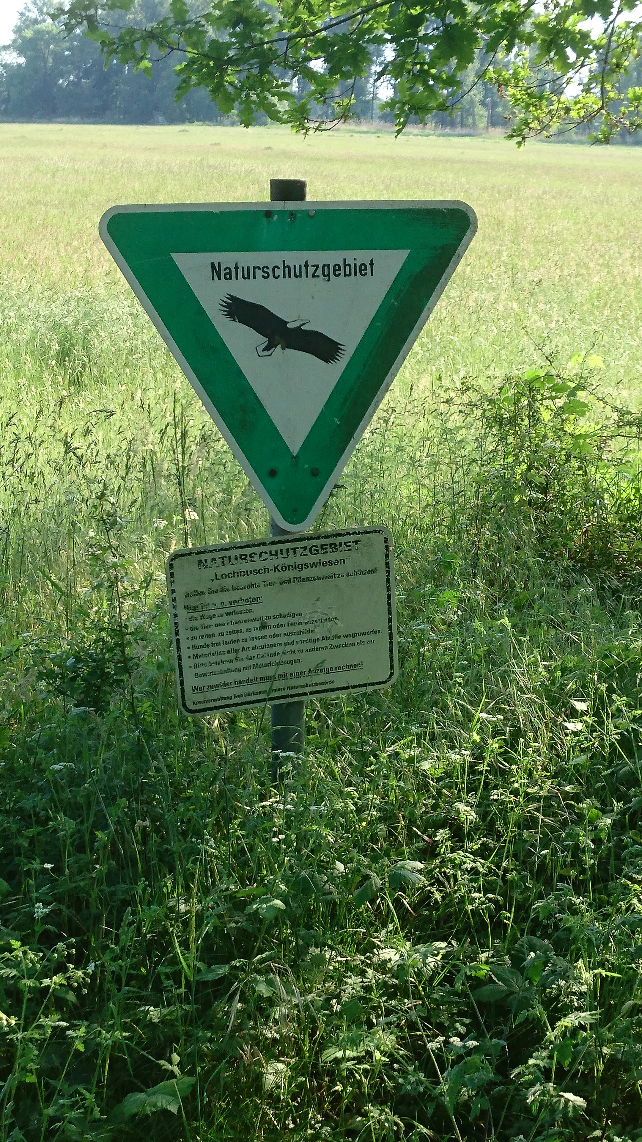
A triangular green and white nature reserve sign, depicting an eagle in flight, mounted above a rectangular information board on a metal post in a grassy field.
A nature reserve sign marking the Lochbusch-Königswiesen area in Germany.

Lochbusch-Königswiesen history and protected-area timeline

Lochbusch-Königswiesen was placed under formal nature protection by a legal ordinance issued on 5 September 1983 by the responsible authorities of Rhineland-Palatinate. The designation formalized protection for an area that had already functioned as an ecologically important floodplain mosaic along the Speyerbach.

The reserve is administered across two municipalities, the independent city of Neustadt an der Weinstraße and the Landkreis Bad Dürkheim, which reflects its position on the boundary between a densely settled wine-growing region and a broader rural district. The area remains one of many small nature reserves in this part of the Palatinate established during the same period to protect remaining natural habitats in the Rhine plain.

Lochbusch-Königswiesen landscape and geographic character

The landscape of Lochbusch-Königswiesen is shaped by its position in the flat Rhine lowlands, where terrain change is subtle and topography is dominated by gentle floodplain features. The Speyerbach runs through the reserve in an east-west direction, providing the hydrological backbone for the area's habitats.

Around the stream corridor, slight depressions hold wetter communities, including Niedermoor (lowland bog) and damp meadow vegetation. Slightly higher and drier ground supports more stable woodland areas and transitional forest edges. The combination of open wet areas and forested patches gives the area a varied visual character despite its small size. On its southern side, the reserve meets transport infrastructure, including the B 39, marking a clear edge between the protected floodplain and the surrounding agricultural and urban land.

Lochbusch-Königswiesen ecosystems, habitats, and plant life

Ecologically, Lochbusch-Königswiesen is defined by the coexistence of Niedermoor, wet meadow (Feuchtwiesen), forest-edge, and woodland communities. This combination of habitats makes the reserve valuable for conservation because these vegetation types are increasingly rare and fragmented in the surrounding landscape.

The wetter communities depend on the hydrology of the Speyerbach, which influences water tables and soil conditions throughout the reserve. The forest-edge communities form transitional zones between wetter and drier habitats, while the more stable woodland areas provide structural contrast within the protected area. Together, these habitat types create a small but ecologically coherent mosaic that supports a range of species typical of lowland floodplain environments.

Lochbusch-Königswiesen conservation status and protection priorities

Conservation significance at Lochbusch-Königswiesen centers on the protection of relict floodplain and wetland habitats in a lowland setting that has otherwise been heavily modified. The reserve preserves Niedermoor and Feuchtwiesen communities that depend on the Speyerbach's hydrology and are vulnerable to drainage, agricultural intensification, and urban expansion.

By protecting this mosaic of bog, wet meadow, and woodland communities in a single contiguous area, the reserve helps maintain ecological connectivity along the Speyerbach corridor. Its proximity to roads, including the B 39, also highlights its role as a conservation refuge within a landscape dominated by transport routes, settlements, and agricultural use.

Top sights and standout views in Lochbusch-Königswiesen

Lochbusch-Königswiesen stands out for its compact preservation of multiple interconnected floodplain habitats within a short reach of an intensively used lowland region. The presence of lowland bog, wet meadows, and forest-edge communities within the same reserve gives it an unusually diverse ecological identity for its size.

Its location along the Speyerbach and its split-city-and-district administration also make the reserve an interesting example of how small protected areas continue to function in landscapes shaped by infrastructure, agriculture, and urban growth.

Monthly climate preview

Long-term monthly temperature averages and precipitation patterns for Lochbusch-Königswiesen

Lochbusch-Königswiesen Climate Normals, Annual Temperature and Precipitation Rhythm

Representative coordinates track measured monthly temperature variations and daily precipitation rates across the recorded climatology period. Detailed twelve-month records provide a complete statistical baseline for analyzing long-term climate patterns at this protected location.
Annual mean10 °C
0 °C20 °C
Jan
Feb
Mar
Apr
May14°
Jun18°
Jul20°
Aug20°
Sep15°
Oct10°
Nov
Dec
Warmest month
July

20.4 °C

Coolest month
January

0.3 °C

Wettest month
July

2.2 mm/day

Driest month
April

1.4 mm/day

Park location guide

Geography guide, regional context, and park location map for Lochbusch-Königswiesen

Lochbusch-Königswiesen park geography, regions, and map view in Germany

Understand where Lochbusch-Königswiesen sits in Germany through a broader geographic reading of the surrounding landscape, nearby location context, and its mapped position within the national park landscape.

How Lochbusch-Königswiesen fits into Germany

Germany is a federal republic in Western and Central Europe with a population of over 83 million across sixteen constituent states. It is Europe's largest economy by nominal GDP and a major global exporter and importer. The capital is Berlin, and the country borders Denmark, Poland, Czech Republic, Austria, Switzerland, France, Luxembourg, Belgium, and the Netherlands.

Wider geography shaping Lochbusch-Königswiesen in Germany

Germany is located in Western and Central Europe, spanning 357,022 km². It borders Denmark to the north, Poland and the Czech Republic to the east, Austria and Switzerland to the south, and France, Luxembourg, Belgium, and the Netherlands to the west. The country has coastlines on the Baltic Sea and North Sea to the north, with the Alps located in the southern region.

Map view of Lochbusch-Königswiesen

Use this park location map to pinpoint Lochbusch-Königswiesen in Germany, understand its exact geographic position, and read its mapped placement within the surrounding landscape more clearly.

Pigeon | © OpenStreetMap contributors

Location context for Lochbusch-Königswiesen

Rheinland-Pfalz

Photographic reference for the Speyerbach floodplain, lowland bogs, and meadow habitats.

Visual Exploration of Lochbusch-Königswiesen Landscapes, Wetlands, and Protected Scenery

Photographic records illustrate the diverse wetland habitats and subtle floodplain terrain defining the protected character of Lochbusch-Königswiesen. Visual documentation captures the lowland bogs, wet meadows, and forest-edge communities thriving along the Speyerbach river corridor.

A triangular green and white nature reserve sign, depicting an eagle in flight, mounted above a rectangular information board on a metal post in a grassy field.

Park atlas

Compare adjacent wetland reserves and lowland nature conservation areas

Other Parks Near Lochbusch-Königswiesen and Protected Areas in the Region

Browse nearby protected landscapes and floodplain nature reserves situated across the surrounding Rhineland-Palatinate lowlands. Continuing the geographic comparison reveals how other regional habitats connect across the Speyerbach river corridor.
A horizontal watercolor painting showing a stylized, soft-focus forest landscape with green trees against a pale, warm-toned ground.
Protected areaRhineland-Palatinate
Mapped location lies within the park boundary#1 closest

Northeast

Speyerer Wald: Protected Alluvial Forest and Inland Sand Dune Landscape

Regional geography and protected area context in Rhineland-Palatinate.

Speyerer Wald offers a look into the formation of Rhine Plain alluvial fans and the survival of forest ecosystems on poor, sandy soils. This protected expanse showcases the intersection of inland dunes, dry sand grasslands, and riparian stream corridors. It serves as a key case study in regional landscape evolution, highlighting how ice age deposits continue to dictate current habitat distribution and nature conservation priorities.

Established
1981
Relief
Lowland
Climate
Temperate
Access
Easy access
A horizontal watercolor illustration depicting a calm lake with grassy foreground reeds and distant soft purple hills under a clear sky.
Nature reserveRhineland-Palatinate
About 7.9 km away#2 closest

Northwest

Mußbacher Baggerweiher Nature Reserve in the Rhineland-Palatinate Protected Landscape Atlas

Wetland habitat mosaic and post-industrial geography

Mußbacher Baggerweiher stands as a textbook example of industrial recovery, where a former extraction site for motorway construction transformed into a thriving protected wetland. Situated in the eastern reaches of Neustadt an der Weinstraße, the reserve offers a dense mosaic of shoreline habitats, sheltered water, and small islands that contribute significantly to regional conservation in the Upper Rhine Plain.

Area
0.205 km²
Established
1989
A soft, light watercolor painting of a rolling rural landscape featuring rows of vineyards in the foreground and tree-covered hills in the distance.
Nature reserveRheinland-Pfalz
About 11 km away#3 closest

North

Haardtrand Nature Reserve: Geographic Overview and Protected Landscape Mapping

Bird protection area within the Rheinland-Pfalz region.

Spanning roughly 14,700 hectares, Haardtrand serves as a critical link between the Palatinate Forest and the Rhine valley. This nature reserve is composed of a distinctive mosaic of habitat types, including mature broadleaf woodlands, traditional orchard meadows, and sandy terraces, which together create a highly structured environment for diverse raptors and forest-dwelling bird species.

Area
147.28 km²
Established
2004
A pale, atmospheric watercolor painting showing a quiet river scene with green trees and a hanging branch in the foreground, rendered in a light and airy style.
Nature reserveRhineland-Palatinate
About 11 km away#4 closest

Southeast

Schwarzwald Nature Reserve: A Protected Rhine Floodplain Landscape in Rhineland-Palatinate

Geographic atlas of alluvial forests and oxbow river dynamics

Schwarzwald represents a significant nature reserve in Germany, characterized by its position between the modern Rhine and the Lingenfelder Altrhein. The area contains a rich collection of floodplain features, including alluvial forests, pollarded willows, and standing gravel pit lakes, offering a comprehensive look at the riparian geography of the Upper Rhine.

Area
3.41 km²
Established
1997
Nature reserveRhineland-Palatinate
About 12 km away#5 closest

South

Bellheimer Wald: Protected Alluvial Forest and Inland Dune Geography in Germany

Nature reserve landscapes in Rhineland-Palatinate

Bellheimer Wald offers a window into the unique geography of the Upper Rhine Plain. This protected forest is characterized by its sandy alluvial soils and rare inland dune systems, forming a core component of the alluvial-fan woodland chain that spans the southern Palatinate and supports complex habitats for specialized flora and fauna.

Area
46.79 km²
Established
2000
IUCN
IV
Relief
Lowland
Nature reserveRheinland-Pfalz
About 12 km away#6 closest

East

Flotzgrün Nature Reserve: Protected Floodplain Landscapes and Rhine Geography in Rheinland-Pfalz

Mapping historical island creation and modern conservation polders

Flotzgrün serves as a compelling geographic entity within the Upper Rhine, functioning as both an active flood management polder and a protected riparian environment. This site offers insights into the intersection of 19th-century river straightening and modern ecological restoration, revealing a landscape defined by controlled wetlands, old river arms, and managed floodplain habitats.

Area
3.4 km²
Relief
Lowland
Scope
Terrestrial
Water
Major water bodies
A horizontal watercolor painting depicting a soft-focus landscape with a central tree, calm water, and rolling hills in the background.
Nature reserveRhineland-Palatinate
About 13 km away#7 closest

Southeast

Brückenkopf Nature Reserve: An Atlas of Protected Floodplain Geography in Rhineland-Palatinate

Detailed mapping of rare wetland habitats and regional floodplain zones

Brückenkopf offers a unique look at small-scale habitat conservation in the Germersheim district. This nature reserve protects a vital fragment of the Upper Rhine floodplain, serving as a sanctuary for specific wetland flora and rare invertebrates. Gain a better understanding of its location between major infrastructure corridors and the river, marking it as a significant component of regional conservation strategy.

Area
0.357 km²
Established
1982
IUCN
IV
Relief
Lowland
Nature reserveRheinland-Pfalz
About 14 km away#8 closest

West

Naturschutzgebiet Am Wolfsberg: Protected Nature Reserve and Botanical Landscape Atlas

Ecological terrain and geological layers in the Palatinate Forest

Naturschutzgebiet Am Wolfsberg is a specialized nature reserve in Rheinland-Pfalz, characterized by its steep, sun-exposed sandstone slopes and rare dry grassland vegetation. This protected area serves as an essential site for studying submediterranean flora and the interplay between historical quarry workings and forest ecosystems. The reserve provides a distinct glimpse into the climatic and geological variety of the Haardt massif.

Area
0.03 km²
Established
1984
Relief
Mountain
Climate
Temperate

Common questions about visiting, size, designation, and location context for Lochbusch-Königswiesen

Lochbusch-Königswiesen FAQs for park facts, access, geography, and protected area context

Find quick answers about Lochbusch-Königswiesen, including protected-area facts, park geography, trail and visitor context, and how the park fits into its surrounding country and regional landscape.
MoriAtlas Explorer

Continue Your Protected Areas Search Across the Global Atlas

Deepen your exploration by continuing the structured search for national parks and protected areas worldwide. Utilize the comprehensive filtering capabilities to compare different conservation landscapes and refine your understanding of global park geography. Discover more about the distribution and characteristics of protected natural areas.

Global natural geography