

Mori Atlas logo
Protected areaLolo National Forest

Traversing high ridges, deep river valleys, and rare old growth conifer stands

Lolo National Forest: A Comprehensive Geographical Survey of Montana Protected Landscapes

Lolo National Forest encompasses two million acres of rugged northern Rocky Mountain terrain in western Montana, stretching from the Continental Divide to the Idaho border. This protected expanse functions as a critical transitional zone where moist Pacific weather patterns meet continental air, fostering an ecological diversity of larch, spruce, fir, and expansive old growth western red cedars. The landscape is defined by its layered topography, ranging from high-altitude subalpine ridges and roadless wilderness areas to dense riparian corridors and numerous lake basins.

national forestMontanaRocky Mountainswestern red cedarold-growth forestwilderness areas

Lolo National Forest

Protected area

Park overview

Structured park overview, official facts, and landscape profile for Lolo National Forest

Lolo National Forest park facts, protected area profile, and essential visitor context

Review the core facts for Lolo National Forest, including designation, size, terrain, visitor scale, habitats, and operating context in one park-focused overview.

About Lolo National Forest

Lolo National Forest is one of the major national forests of the northern Rocky Mountains, occupying a broad belt of mountainous country in western Montana that extends westward to the Idaho state line. With headquarters in Missoula and territory wrapping around that city, the forest sits in a strategic position between the Continental Divide and the deep river valleys that drain toward the Columbia River system. Its sheer scale, together with the variety of landscapes it contains, gives it a central role in the forested landscape of the inland Pacific Northwest.

Ecologically, Lolo is defined by the meeting of two climatic worlds. East of the Divide, much of Montana's forest vegetation reflects a drier, more continental climate. West of the Divide, moisture-laden air off the Pacific supports denser, more Pacific-influenced forests. Lolo sits firmly on the maritime side, and this transitional condition has long made it a focus of interest for botanists and forest ecologists. The result is a forest in which western red cedar, western larch, whitebark pine, Douglas-fir, and various spruces coexist, often within the same drainage.

The forest's four wilderness areas reinforce its conservation significance. Welcome Creek and Rattlesnake Wildernesses are contained entirely within Lolo, while the Scapegoat and Selway-Bitterroot Wildernesses overlap its boundaries. Together they preserve large tracts of roadless backcountry within the larger forest matrix, anchoring habitat for wide-ranging species. Wildlife in the forest is correspondingly rich, with grizzly bears, black bears, elk, moose, mule deer, mountain goats, bighorn sheep, mountain lions, and timber wolves all present in the landscape, alongside large raptors and a wide variety of waterfowl, including trumpeter swans and herons.

Beyond its natural assets, Lolo carries strong cultural and historical associations. The forest lies along the Lolo Trail, a historic travel route used by the Nez Perce and crossing the Bitterroot Mountains. This same corridor became part of the route followed by the Lewis and Clark Expedition. Today the forest contains the Lolo National Historic Trail, the Ninemile Wildlands Training Center near Frenchtown, and the Savenac Historic Tree Nursery near Haugan, a former U.S. Forest Service nursery that is now a designated National Historic Site. These places give Lolo a layered human history that complements its ecological profile.

Quick facts and research context for Lolo National Forest

Lolo National Forest covers approximately 2 million acres west of the Continental Divide in western Montana, with its western edge forming part of the Montana-Idaho border. It was established on September 20, 1906, and is administered by the U.S. Forest Service, with its headquarters in Missoula, Montana.

The forest contains four wilderness areas, including the Welcome Creek and Rattlesnake Wildernesses, which lie entirely within Lolo, and portions of the Scapegoat and Selway-Bitterroot Wildernesses. Across this landscape it protects about 1,500 plant species, around 300 bird species, roughly 60 mammal species, and 20 varieties of fish. The forest's tallest point is Scapegoat Mountain, and it includes over 100 named lakes and an extensive network of rivers led by the Flathead River.

Protection and recognition

Examine documented protected area designation details for Lolo National Forest

Lolo National Forest Protection Status and Terrestrial Conservation Scope

Lolo National Forest maintains a documented terrestrial protection scope without imported international recognition sources. Review structured conservation facts and administrative status details for this protected area.

Protection details

Protection scope
Terrestrial
Transboundary protection
No
Park context

Deeper park guide and search-rich context for Lolo National Forest

Lolo National Forest history, landscape, wildlife, and travel context

Explore Lolo National Forest through its history, landscape character, ecosystems, wildlife, conservation priorities, cultural context, and seasonal travel timing in a structured park guide built for atlas discovery and search intent.

Why Lolo National Forest stands out

Lolo National Forest is best known for the exceptional size of its western red cedars, which grow larger inside the forest than anywhere else in Montana. These cedars reach diameters of more than 8 feet and heights approaching 200 feet, anchoring the forest's identity as a stronghold for old-growth conifers in the Northern Rockies. The forest is also recognized for its transitional ecology. Because it lies west of the Continental Divide, it receives both continental and maritime weather influences, producing a blending of dry interior species with moisture-loving Pacific Northwest species. This combination supports an unusually rich mix of larch, whitebark pine, spruce, fir, and cedar in a single contiguous forest. Add to that the historic Lolo Trail corridor traveled by the Nez Perce and the Lewis and Clark Expedition, and the forest stands out as both an ecological and a cultural landmark of the northern Rockies.
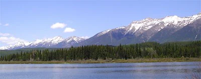
Rainy Lake
Rainy Lake located within Lolo National Forest, Montana, United States.

Lolo National Forest history and protected-area timeline

Lolo National Forest was established on September 20, 1906, consolidating four predecessor forests for administrative efficiency. Its original area of about 1.2 million acres represented an early attempt to bring unified management to a complex of forested drainages west of the Continental Divide.

The forest grew over the following decades through successive administrative mergers. On December 16, 1931, portions of the former Missoula National Forest were added to Lolo. In 1934, parts of the Selway National Forest, on the other side of the Montana-Idaho line, were incorporated. Finally, in 1954, sections of the Cabinet National Forest were added. Through these mergers, Lolo acquired the broader footprint and the four wilderness components that today help define its character.

In addition to its administrative history, the forest overlaps landscapes of deep cultural and historic significance. The Lolo Trail corridor through the Bitterroot Mountains had been used for generations by the Nez Perce and is closely associated with the overland journey of the Lewis and Clark Expedition. Within the forest, the Savenac Historic Tree Nursery, a former U.S. Forest Service nursery near Haugan, has been recognized as a National Historic Site, and the Ninemile area near Frenchtown preserves remount depot structures listed on the National Register of Historic Places. These sites together trace a long arc from indigenous travel routes through early 20th-century forest management.

Lolo National Forest landscape and geographic character

Lolo National Forest occupies a rugged slice of the northern Rocky Mountains west of the Continental Divide. The terrain is shaped by long, forested north-south ridges separated by river valleys that drain toward the Clark Fork and the Flathead River systems. The forest's highest point is Scapegoat Mountain, reaching above 9,000 feet, while lower elevations drop into river canyons and lake basins studded with more than a hundred named lakes.

Five major rivers flow through or originate in the forest, with the Flathead River among the most prominent. The combination of high peaks, mid-elevation plateaus, deep valleys, and clearwater lakes gives Lolo a layered topography that shifts from subalpine environments on the ridges to dense riparian corridors along the rivers. The valleys around Missoula and downstream to the west are flanked by mixed conifer forests that climb gradually into colder, snowier terrain.

Because the forest lies west of the Divide, it receives significant moisture fromPacific weather systems. This produces a landscape that is heavily forested, with dense stands of conifers blanketing much of the terrain. Rugged roadless basins and broad forested plateaus alternate across the wilderness areas, while the rivers and lakes break the canopy and create the open scenery that defines much of the visitor experience.

Lolo National Forest ecosystems, habitats, and plant life

The vegetation of Lolo National Forest is shaped by its position west of the Continental Divide, where Pacific moisture sustains a notably diverse forest cover. The forest is widely recognized as a transitional environment: continental interior species share the landscape with maritime-influenced Pacific Northwest species, producing a richer mix of trees than is typical for a single national forest.

Western red cedar is one of the forest's signature trees, reaching dimensions here that exceed those found elsewhere in Montana. Western larch, a deciduous conifer adapted to fire-prone landscapes, is also characteristic, as is whitebark pine, a high-elevation species of ecological concern across the West. These share the forest with several species of spruce and fir, as well asDouglas-fir, creating a layered canopy structure across elevation and moisture gradients.

Across roughly 1,500 documented plant species, the forest supports a wide variety of understory communities, from moist cedar-hemlock type draws to drier, more open pine stands. Riparian zones along the Flathead River and other waterways add a further dimension, hosting moisture-loving plants and providing the wetland habitat that supports much of the forest's waterfowl and shorebird diversity.

Lolo National Forest wildlife and species highlights

Lolo National Forest supports one of the most complete mammal communities of any national forest in the northern Rockies. Large carnivores are well represented, with both grizzly and black bears present, along with cougars and timber wolves. The forest also hosts mountain goats and bighorn sheep on its higher, more rugged terrain, while elk, moose, and mule deer range widely across its mid- and low-elevation habitats. The presence of these wide-ranging species is closely tied to the forest's large roadless wilderness areas, which provide secure core habitat.

The forest's birdlife is correspondingly diverse, with around 300 recorded species. Large raptors are anchored by breeding populations of both bald eagles and golden eagles, while wetlands and lakes support trumpeter swans, several species of herons, and approximately 30 varieties of ducks. The combination of high-elevation forest, low-elevation riparian corridors, and open water creates habitat for a wide spectrum of nesting and migratory birds.

Rivers and lakes add a further wildlife dimension. Cold, clean waters sustain roughly 20 varieties of fish, including native salmonids, while amphibians and aquatic invertebrates occupy the forest's many streams. Wildlife viewing, big-game habitat, and intact predator-prey systems remain central to the forest's ecological identity and its appeal to visitors.

Lolo National Forest conservation status and protection priorities

Lolo National Forest plays an important conservation role in the northern Rockies because of its scale, ecological diversity, and the quality of its wilderness blocks. With about 2 million acres of contiguous forest, it helps maintain landscape-scale connectivity between core habitats in Montana and Idaho, especially for wide-ranging species such as grizzly bears, wolves, elk, and mountain lions that require extensive, unbroken terrain.

Its four wilderness areas strengthen this conservation role. Welcome Creek and Rattlesnake Wildernesses lie entirely within the forest, while portions of the Scapegoat and Selway-Bitterroot Wildernesses extend into Lolo's boundaries. Together they preserve significant roadless acreage and represent important reference areas for monitoring how Rocky Mountain ecosystems function under minimal direct human disturbance.

The forest is also a stronghold for western red cedar, larch, and whitebark pine, including old-growth stands of unusual age and dimension. Protection of these tree communities, and of the transitional climate zone that supports them, makes Lolo a key site for understanding how continental and maritime influences interact in inland forests of the American West.

Lolo National Forest cultural meaning and human context

Lolo National Forest has a rich cultural context shaped by centuries of travel across the Bitterroot Mountains and by the administrative history of American forestry. The forest overlaps the Lolo Trail corridor, a route traditionally used by the Nez Perce and later a central segment of the overland route taken by the Lewis and Clark Expedition. Today this corridor is commemorated as the Lolo National Historic Trail, connecting the forest's landscape to broader narratives of indigenous travel and early Euro-American exploration of the West.

Within the forest itself, the Savenac Historic Tree Nursery near Haugan reflects a different chapter of cultural history. Operated by the U.S. Forest Service in the early 20th century, the nursery is now a designated National Historic Site, illustrating the institutional roots of American forest management. Near Frenchtown, the Ninemile area preserves structures associated with the U.S. Forest Service remount program, with features listed on the National Register of Historic Places. Together these sites mark the forest as a place where indigenous history, exploration, and the development of modern forestry intersect.

Missoula, the forest's headquarters city, sits centrally within sight of forestlands and serves as a regional cultural hub tied to the Forest's identity. Local communities throughout the forest's footprint have long-standing relationships with the landscape through forestry, ranching, recreation, and outdoor heritage.

Top sights and standout views in Lolo National Forest

Lolo stands out for the scale and ecological character of its old-growth western red cedar forests, which reach sizes unmatched elsewhere in Montana. The forest's four wilderness areas, especially the wholly-contained Welcome Creek and Rattlesnake Wildernesses, anchor large blocks of roadless habitat in the northern Rockies.

Its transitional climate, where continental weather meets moist Pacific air, supports an unusually rich mix of conifer species in a single landscape. Combined with the historic Lolo Trail, the Savenac nursery, and abundant water-based recreation on more than 100 named lakes and the Flathead River, the forest offers a layered combination of ecological, cultural, and recreational significance.

Best time to visit Lolo National Forest

Summer is the most accessible time to visit Lolo National Forest, when snow has retreated from higher elevations and the network of campgrounds, lakes, and hiking trails is fully open. The long daylight hours of the northern Rockies summer are well suited to exploring both low-elevation river valleys and the higher ridges of the wilderness areas, where wildflowers are typically at their peak in mid- to late summer.

Autumn brings its own character, with western larch turning golden across the forest and cooler temperatures that are favorable for wildlife viewing and hiking. Winter conditions in Lolo are cold and snowy, with heavy snowfall in the higher terrain, shaping the landscape into a snow-covered backcountry. Spring is a transitional season, with runoff swelling rivers and streams and gradually opening up lower-elevation trails as the snow line retreats up the mountains.
Monthly climate preview

Long-term temperature and precipitation records across twelve months

Lolo National Forest Climate Normals and Annual Weather Patterns

Representative coordinate measurements reveal marked annual temperature variations alongside consistent monthly precipitation patterns for Lolo National Forest. Examining the complete monthly climate profile provides deeper insight into long-term averages and regional weather behavior.
Annual mean5 °C
-7 °C18 °C
Jan-7°
Feb-6°
Mar-1°
Apr
May
Jun13°
Jul18°
Aug18°
Sep12°
Oct
Nov-2°
Dec-7°
Warmest month
July

17.9 °C

Coolest month
January

-6.9 °C

Wettest month
November

2.7 mm/day

Driest month
August

1 mm/day

Park location guide

Geography guide, regional context, and park location map for Lolo National Forest

Lolo National Forest park geography, regions, and map view in United States of America

Understand where Lolo National Forest sits in United States of America through a broader geographic reading of the surrounding landscape, nearby location context, and its mapped position within the national park landscape.

How Lolo National Forest fits into United States of America

The United States of America is a federal presidential republic and one of the world's largest countries by area and population. It consists of 50 states across a vast territory spanning multiple time zones, with its capital in Washington, D.C. and largest city in New York City. The nation has a diverse economy, influential political system, and significant cultural and military presence globally.

Wider geography shaping Lolo National Forest in United States of America

The United States occupies a vast territory in North America, bordered by Canada to the north and Mexico to the south. The 48 contiguous states stretch from the Atlantic to the Pacific Ocean, while Alaska occupies the northwestern region and Hawaii is an archipelago in the Pacific. The country encompasses diverse terrain including the Rocky Mountains, Appalachian Mountains, Great Plains, and extensive river systems.

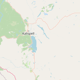
Map view of Lolo National Forest

Use this park location map to pinpoint Lolo National Forest in United States of America, understand its exact geographic position, and read its mapped placement within the surrounding landscape more clearly.

Pigeon | © OpenStreetMap contributors

Location context for Lolo National Forest

Montana
Natural feature types

Browse the Full Collection of Lolo National Forest Geographic Features

Navigate the diverse landscape of Lolo National Forest by browsing its cataloged natural landmarks. This MoriAtlas collection offers a detailed look at the mountains, rivers, and wilderness basins that define the geography of the Northern Rockies. Examine the regional terrain and discover the natural formations that make this forest a unique ecological study.
Recorded earthquake history

Review the Lolo National Forest Earthquake History and Seismic Data Catalogue

Examine the historical record of seismic events associated with the rugged terrain of Lolo National Forest. This collection of data points allows for an objective look at documented earthquake activity throughout the forest geography as provided by USGS records.

Lolo National Forest Earthquake Records

Catalogued events

231 events

Strongest magnitude

Magnitude 5.8

Most recent event

Aug 28, 2026

This history includes earthquakes recorded inside the park or within 50 km of its borders

Explore protected area photography, old growth cedar habitats, and mountain terrain views.

Lolo National Forest Photos and Landscape Scenery Visual Reference

Visual documentation captures the rugged mountain ridges, dense conifer canopies, and old growth cedar groves characteristic of Lolo National Forest. Examining these protected area photographs reveals the transitional ecology and diverse river valley terrain spanning western Montana.

Rainy Lake

Park atlas

Compare regional mountain terrain and connected wilderness landscapes

Explore Parks Near Lolo National Forest and Surrounding Protected Areas

Visitors exploring Lolo National Forest can browse adjacent protected areas and neighboring mountain reserves. Comparing regional ecosystems highlights the diverse transition zones across the northern Rocky Mountains.
Protected landscapeMontana
Park boundaries overlap#1 closest

East

Helena-Lewis and Clark National Forest: Geographic Overview and Protected Area Map

Montana wilderness spanning the Continental Divide

Spanning from the rolling eastern plains to the crest of the Northern Rockies, Helena-Lewis and Clark National Forest serves as a massive protected landscape in central Montana. This forest system protects eight unique mountain ranges and critical wilderness corridors, offering a comprehensive look at the ecological transition zones of the American Mountain West.

Area
11,000 km²
Established
1897
Relief
Mountain
Climate
Temperate
Protected landscapeMontana
Park boundaries overlap#2 closest

Northwest

Kootenai National Forest: Geography and Protected Land Map for Northwestern Montana

Northern Rockies mountain ranges and watershed analysis.

Spanning over two million acres, Kootenai National Forest represents a critical protected landscape in the Northern Rockies. This atlas entry details the interplay between the Cabinet Mountains, regional river systems like the Kootenai and Clark Fork, and the dense conifer forests that define this uniquely wet corner of Montana.

Area
8,900 km²
Established
1907
Relief
Mountain
Climate
Temperate
Wildlife reserveMontana
Park boundaries overlap#3 closest

Northeast

Mission Mountains Wilderness: A Rugged Protected Area in the Montana Rocky Mountains

Glacial topography and high elevation alpine ecosystems

Mission Mountains Wilderness is a defining landmark in northwestern Montana, characterized by a steep and narrow mountain spine that rises abruptly above the Flathead Valley. The area protects a full spectrum of ecosystems, from dense coniferous forests to exposed talus slopes and alpine tundra. With its glacially carved cirques and deep U shaped valleys, this wilderness functions as a key component of a larger, jointly managed regional conservation landscape in the United States.

Area
298.97 km²
Established
1975
IUCN
Ib
Relief
Mountain
Protected landscapeMontana
Mapped location lies within the park boundary#4 closest

Southeast

Rattlesnake National Recreation Area: Geography and Protected Landscape Analysis

A mapped Northern Rockies gateway in western Montana

The recreation area encompasses 28,000 acres of forested mountain terrain, montane wetlands, and creek-carved valleys located just north of Missoula. This protected landscape is defined by its diverse trail network and significant ecological systems, including the rare Sphagnum bogs of Shoo Fly Meadows. The area provides essential habitat for grizzly bears, elk, and bull trout while framing a transition zone into the remote backcountry of the surrounding national forest.

Area
110 km²
Established
1980
Relief
Mountain
Scope
Terrestrial
Wildlife reserveMontana
Park boundaries overlap#5 closest

East

Rattlesnake Wilderness: Exploring the Protected Landscapes and Geography of Montana

Rugged alpine terrain and roadless mountain wilderness in the Northern Rockies.

Located in the Lolo National Forest of western Montana, Rattlesnake Wilderness protects an essential network of forested slopes, alpine ridges, and drainage headwaters. This roadless wildlife reserve provides an ecologically intact landscape that serves as a core component of the northern Rockies wilderness system, offering a clear view into the rugged relief of the Rattlesnake Mountains and their significant influence on local watersheds.

Area
133.45 km²
Established
1980
IUCN
Ib
Relief
Mountain
Protected landscapeIdaho
About 39 km away#6 closest

Northwest

Idaho Panhandle National Forests: Mapping the Inland Pacific Northwest Protected Landscapes

Geographic analysis of mountain ranges and river valley ecosystems

Spanning over 2.5 million acres, the Idaho Panhandle National Forests comprise a massive, interconnected network of mountain ranges, pristine lakes, and river corridors. This detailed look at the geography examines the structural backbone of the Selkirk, Cabinet, and Bitterroot ranges, highlighting the diverse ecological gradients and protected wilderness areas that characterize this significant portion of the inland Northwest.

Area
13,000 km²
Established
1912
Relief
Mountain
Climate
Temperate
Protected landscapeIdaho
69 km away#7 closest

South

Salmon, Challis National Forest: Geography and Protected Land Map in Central Idaho

Extensive alpine ridges and wild river corridors

Spanning over 4.2 million acres, Salmon, Challis National Forest is a foundational protected landscape in Idaho. This area includes the highest peaks in the state, such as Borah Peak, and holds the majority of the Frank Church, River of No Return Wilderness. Utilize this atlas resource to examine the intricate mountain topography, expansive river systems, and the contiguous wild corridors that define this significant portion of the northern Rockies.

Area
17,142.2 km²
Established
1908
Relief
Mountain
Climate
Temperate
Wildlife reserveMontana
75 km away#8 closest

East

Gates of the Mountains Wilderness: Montana Protected Landscape and Geographic Overview

Explore Missouri River canyon boundaries and local terrain

Gain insight into the geological drama of Gates of the Mountains Wilderness, a protected reserve in Montana. This atlas entry focuses on the limestone canyon walls and historic river corridors that define the regional geography, offering a structured look at its protected boundaries and terrain.

Area
115.59 km²
Established
1964
IUCN
Ib
Relief
Mountain

Common questions about visiting, size, designation, and location context for Lolo National Forest

Lolo National Forest FAQs for park facts, access, geography, and protected area context

Find quick answers about Lolo National Forest, including protected-area facts, park geography, trail and visitor context, and how the park fits into its surrounding country and regional landscape.
MoriAtlas Explorer

Continue Your Protected Areas Search Across the Global Atlas

Deepen your exploration by continuing the structured search for national parks and protected areas worldwide. Utilize the comprehensive filtering capabilities to compare different conservation landscapes and refine your understanding of global park geography. Discover more about the distribution and characteristics of protected natural areas.

Global natural geography