Mori Atlas logo
Nature reserveLopez Watershed Forest Reserve

A foundational nature reserve and essential watershed catchment on the island of Luzon.

Lopez Watershed Forest Reserve: Examining the Protected Rainforest Landscape in Quezon Province

Lopez Watershed Forest Reserve represents a critical protected landscape within the rolling hill terrain of Quezon province. Established in 1940, this nature reserve anchors a vital network of tropical rainforests and watershed catchments on Luzon. Explore the topography, protected boundaries, and regional ecological significance of this foundational NIPAS component through our detailed geographic data.

watershed forest reservetropical rainforestLuzonQuezon provincelowland forestlower montane forest

Lopez Watershed Forest Reserve

Nature reserve

Park overview

Structured park overview, official facts, and landscape profile for Lopez Watershed Forest Reserve

Lopez Watershed Forest Reserve park facts, protected area profile, and essential visitor context

Review the core facts for Lopez Watershed Forest Reserve, including designation, size, terrain, visitor scale, habitats, and operating context in one park-focused overview.

About Lopez Watershed Forest Reserve

The Lopez Watershed Forest Reserve sits in the southern portion of Luzon, within the province of Quezon, one of the Philippines' most agriculturally significant provinces. The reserve was established on 22 June 1940 and covers an area of 418 hectares distributed across the municipal jurisdictions of Lopez, Calauag, and Guinayangan. Its creation predates many of the Philippines' modern conservation measures and reflects an early recognition of the ecological value of forested watersheds in the region.

The reserve lies in a landscape where low hills transition between coastal lowlands and the interior of southern Luzon. Elevations within the reserve range roughly from 200 to 400 meters above sea level, placing it firmly within the lower montane zone where tropical rainforest is typically well developed. The climate is consistently tropical and humid, with no pronounced dry season, conditions that support dense, evergreen vegetation throughout the year.

Though small, the Lopez Watershed Forest Reserve plays several roles: it protects a stretch of primary and secondary rainforest, helps safeguard watershed functions in a populated region, and provides limited agroforestry opportunities for the surrounding communities. Its formal recognition under NIPAS Act 7586 as an initial component anchors it within the broader Philippine protected area system and ensures a baseline level of institutional protection that continues today.

Quick facts and research context for Lopez Watershed Forest Reserve

The Lopez Watershed Forest Reserve is a 418-hectare protected forest on Luzon, Philippines. It lies in Quezon province, covering parts of Lopez, Calauag, and Guinayangang. Established on 22 June 1940, it was included among the initial components of the NIPAS Act 7586.

Park context

Deeper park guide and search-rich context for Lopez Watershed Forest Reserve

Lopez Watershed Forest Reserve history, landscape, wildlife, and travel context

Explore Lopez Watershed Forest Reserve through its history, landscape character, ecosystems, wildlife, conservation priorities, cultural context, and seasonal travel timing in a structured park guide built for atlas discovery and search intent.

Why Lopez Watershed Forest Reserve stands out

The reserve is best known as one of the earliest formally recognized watershed forest reserves in the CALABARZON region of Luzon. It protects a continuous block of lowland and lower-montane tropical rainforest in the rolling hills of southern Quezon, and it was incorporated into the NIPAS system as an initial component, giving it a place in the institutional history of Philippine conservation.

Lopez Watershed Forest Reserve history and protected-area timeline

The Lopez Watershed Forest Reserve was formally established on 22 June 1940, covering 418 hectares across the municipalities of Lopez, Calauag, and Guinayangan in Quezon province. Its creation in the late American colonial period reflects an early era of Philippine conservation, when forested watersheds were recognized for the ecological services they provided to surrounding agricultural and residential communities.

Decades later, the reserve gained renewed institutional importance when it was included among the initial protected areas defined under the NIPAS Act 7586, the National Integrated Protected Areas System. This legislation formed the modern backbone of Philippine conservation policy and brought the older watershed reserve into a unified national framework. As a result, the Lopez Watershed Forest Reserve carries both historical and contemporary significance within the CALABARZON region's network of protected natural areas.

Lopez Watershed Forest Reserve landscape and geographic character

The reserve occupies a hilly section of southern Quezon province on the island of Luzon. The terrain rises gradually from surrounding lowlands into rolling hills, with elevations inside the reserve spanning roughly 200 to 400 meters above sea level. This topographic range places it within the lower montane zone of Luzon and provides a varied substrate for forest growth and microhabitat differentiation.

The broader landscape is shaped by the typical geographic pattern of southern Luzon: a sequence of agricultural lowlands fringed by forested hills that serve as watershed catchments. Within this setting, the Lopez Watershed Forest Reserve functions as a relatively intact patch of natural vegetation, offering contiguity with neighboring forest reserves such as Calauag and Mulanay that together form a loose network of protected hill forests in the region.

Lopez Watershed Forest Reserve ecosystems, habitats, and plant life

The reserve protects a significant stand of tropical rainforest typical of the southern Luzon foothills. Continuous canopy cover, dense understory growth, and the absence of a pronounced dry season support a structurally complex evergreen forest system. Within the reserve, vegetation patterns generally reflect the gradient between more accessible lowland forest at lower elevations and slightly more rugged, less disturbed forest on the steeper slopes.

Portions of the reserve are used in agroforestry by local communities, creating a mosaic where cultivated tree crops, managed forest patches, and more natural vegetation coexist. This blend reflects the broader reality of watershed reserves in populated Philippine provinces, where conservation and rural livelihoods are closely intertwined.

Lopez Watershed Forest Reserve wildlife and species highlights

The Lopez Watershed Forest Reserve shelters a representative share of the flora and fauna typical of southern Luzon's lowland and lower-montane rainforests. Forest cover at these elevations provides habitat for native trees, understory plants, birds, small mammals, and insects associated with continuous tropical forest. While the reserve's size limits the population of wide-ranging species, the intact forest structure offers important local refuge value within an otherwise heavily populated and agricultural landscape.

Within the regional context of CALABARZON, the reserve contributes to a broader network of forest patches that together sustain wider biodiversity patterns, including for bird species that depend on interior forest habitat.

Lopez Watershed Forest Reserve conservation status and protection priorities

The reserve's conservation significance derives less from its absolute size than from its institutional role and its function within a broader watershed and biodiversity network. Its inclusion as an initial component of the NIPAS Act 7586 ties it to the principal Philippine framework for protected area management, ensuring formal recognition, regulatory protection, and integration into national conservation planning.

Beyond its formal status, the reserve contributes to watershed stability for downstream communities in Lopez, Calauag, and Guinayangan, an essential function in a region where forests influence water availability, soil retention, and flood mitigation. Its role as a stronghold of rainforest habitat within a heavily inhabited agricultural landscape amplifies its value as a refuge for native biodiversity.

Lopez Watershed Forest Reserve cultural meaning and human context

The reserve exists within a landscape shaped by generations of rural Philippine communities whose livelihoods depend on agriculture, fishing, and small-scale forest use. Local populations in Lopez, Calauag, and Guinayangan have long interacted with the surrounding forest, and limited agroforestry activities continue within parts of the reserve today. This relationship between forest and community is a defining cultural feature of watershed reserves throughout the Quezon region.

Top sights and standout views in Lopez Watershed Forest Reserve

The Lopez Watershed Forest Reserve stands out as a small but enduring piece of southern Luzon's forested landscape. Its 1940 establishment makes it one of the older formal forest reserves in the region, and its inclusion among the initial NIPAS components gives it lasting institutional significance. Compact rainforest cover, rolling hill topography, and an intertwined agroforestry tradition make the reserve a representative example of watershed protection in populated Philippine countryside.

Best time to visit Lopez Watershed Forest Reserve

Given the tropical humid climate with no marked dry season, the Lopez Watershed Forest Reserve is not subject to sharp seasonal changes in accessibility or vegetation. Rainfall patterns may influence the ease of travel and the intensity of forest soundscapes and stream flow, but the evergreen character of the rainforest means the area retains its forested atmosphere year-round. Visitors interested in lush vegetation and active waterways may find the wetter months particularly vivid, while drier windows can offer easier trail conditions.

Monthly climate preview

Long-term representative monthly temperature and precipitation rhythm in Quezon

Lopez Watershed Forest Reserve Climate Normals and Annual Temperature Patterns

Historical data from 1991 to 2020 documents the measured monthly temperature progression and precipitation rhythm recorded at a representative coordinate within Lopez Watershed Forest Reserve. Reviewing the complete twelve-month profile reveals detailed baseline climate normals across changing seasonal conditions.
Annual mean27 °C
25 °C29 °C
Jan25°
Feb25°
Mar26°
Apr28°
May29°
Jun28°
Jul27°
Aug27°
Sep27°
Oct27°
Nov26°
Dec26°
Warmest month
May

28.7 °C

Coolest month
January

24.8 °C

Wettest month
December

17.5 mm/day

Driest month
April

3.4 mm/day

Park location guide

Geography guide, regional context, and park location map for Lopez Watershed Forest Reserve

Lopez Watershed Forest Reserve park geography, regions, and map view in Philippines

Understand where Lopez Watershed Forest Reserve sits in Philippines through a broader geographic reading of the surrounding landscape, nearby location context, and its mapped position within the national park landscape.

How Lopez Watershed Forest Reserve fits into Philippines

The Philippines, officially the Republic of the Philippines, is an archipelagic nation in Southeast Asia comprising approximately 7,641 islands categorized into three main geographical divisions: Luzon, Visayas, and Mindanao. Located in the western Pacific Ocean, it shares maritime borders with Taiwan, Japan, Palau, Indonesia, Malaysia, Vietnam, and China. Manila serves as the capital city, while Quezon City is the most populated city, both within Metro Manila.

Wider geography shaping Lopez Watershed Forest Reserve in Philippines

The Philippines is an archipelagic nation in Southeast Asia, positioned in the western Pacific Ocean. Its islands are bounded by the South China Sea to the west, Philippine Sea to the east, and Celebes Sea to the south. The country shares maritime borders with Taiwan to the north, Japan to the northeast, Palau to the east and southeast, Indonesia to the south, Malaysia to the southwest, Vietnam to the west, and China to the northwest.

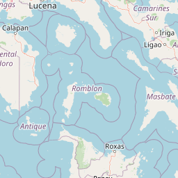
Map view of Lopez Watershed Forest Reserve

Use this park location map to pinpoint Lopez Watershed Forest Reserve in Philippines, understand its exact geographic position, and read its mapped placement within the surrounding landscape more clearly.

Pigeon | © OpenStreetMap contributors

Location context for Lopez Watershed Forest Reserve

Quezon
Park atlas

Compare adjacent forest reserves and regional protected terrain across southern Luzon

Explore Other Parks Near Lopez Watershed Forest Reserve and Surrounding Protected Landscapes

Continue browsing other parks near Lopez Watershed Forest Reserve to examine connected lowland rainforest habitats across southern Quezon province. Comparing these neighboring protected areas reveals broader geographic patterns in regional watershed conservation and hill topography.
Wildlife reserveQuezon
About 4.9 km away#1 closest

Northwest

Calauag Watershed Reservation: Geographic Analysis of Protected Rainforest in Quezon Province

Mapping lowland tropical forest terrain and regional watershed boundaries

Located in the rolling hills of Quezon, the Calauag Watershed Reservation serves as a critical protected landscape featuring dense stands of Philippine hardwoods and varied forest microhabitats. This record details the reserve's topography, ranging from moderate slopes to drainage corridors, illustrating its function as both a biodiversity sanctuary and a essential water catchment for the surrounding CALABARZON region.

Area
3.28 km²
Established
1939
Relief
Upland
Climate
Tropical
Protected areaCamarines Norte
About 46 km away#2 closest

East

Abasig-Matogdon Mananap Natural Biotic Area: Regional Geography and Protected Forest Terrain

A vital ecological reserve in the Bicol Region of Luzon

Located in Camarines Norte, the Abasig-Matogdon Mananap Natural Biotic Area protects critical lowland and montane rainforests surrounding Mount Labo. This area serves as a key component of the regional conservation landscape, defined by its steep volcanic terrain, numerous geothermal springs, and habitat for endemic species within the Philippine archipelago.

Area
54.2 km²
Established
2000
Relief
Mountain
Climate
Tropical
Wildlife reserveQuezon
About 47 km away#3 closest

Northwest

Alabat Watershed Forest Reserve: Wildlife Reserve and Regional Watershed Geography in Quezon

Exploring the protected lowland rainforests of Alabat Island.

Located in Quezon, the Alabat Watershed Forest Reserve represents a significant wildlife reserve defined by its ridge and valley topography. The landscape serves as a protected catchment for the Langas River, maintaining essential lowland forest cover amidst the island environment. This entity provides a clear look at the ecological significance and mapped boundaries of a vital Philippine watershed and forest system.

Area
6.88 km²
Established
1987
Relief
Upland
Scope
Terrestrial
Wildlife reserveQuezon
About 62 km away#4 closest

South

Mulanay Watershed Forest Reserve: Mapping Protected Lowland Rainforests in Quezon

A watershed conservation site on the Bondoc Peninsula

Spanning 474 hectares in the province of Quezon, the Mulanay Watershed Forest Reserve acts as a protected anchor for local biodiversity and hydrological health. The reserve preserves rolling, forest-covered hills that feed the Cawayan Creek, illustrating the importance of small, strategically managed protected lands within the larger Philippine conservation framework.

Area
4.74 km²
Established
1938
Relief
Upland
Water
Minor water
Protected landscapeQuezon
About 63 km away#5 closest

West

Quezon Protected Landscape: Mapping the Rainforests and Karst Terrain of Quezon Province

An essential protected landscape in the southern Sierra Madre mountain range.

Quezon Protected Landscape serves as a vital ecological corridor, featuring a rugged mix of karst topography, lowland rainforests, and underground water systems. Explore the geographic layout of this Philippine reserve, which encompasses symbolic summits, cascading waterfalls, and diverse endemic habitats within the southern Sierra Madre foothills.

Area
9.38 km²
Established
2003
IUCN
V
Relief
Mountain
National parkPhilippines
About 68 km away#6 closest

East

Libmanan Caves National Park: Philippines National Park and Mapped Landscape

Explore protected area boundaries and regional geography.

Libmanan Caves National Park is a protected national park within the Philippines, offering a distinct focus for geographic discovery. This entry provides detailed context on its mapped landscape and its place within the archipelago's protected areas. Users can gain a clear understanding of the park's regional setting, facilitating atlas-style exploration and comprehension of its conservation significance within the Philippine geography.

Area
0.194 km²
Established
1934
IUCN
III
Relief
Upland
A horizontal watercolor painting of a mangrove forest with green canopies and characteristic prop roots rising from calm, reflective mudflats against a white background.
Protected landscapeCalabarzon
About 70 km away#7 closest

Southeast

Alibijaban Protected Landscape and Seascape: Coastal and Marine Geography

A protected island refuge in the Ragay Gulf of Calabarzon

The Alibijaban Protected Landscape and Seascape is a significant conservation site known for its undisturbed mangrove interior and thriving coral reef ecosystems. Its geography features flat terrain, sandy beaches, and complex seagrass meadows that attract diverse wildlife. This map-based overview provides detailed insights into the protected island's physical boundaries and unique marine-terrestrial intersection.

Area
10.56 km²
Established
1981
Relief
Lowland
Climate
Tropical
Wildlife reserveMarinduque
About 72 km away#8 closest

Southwest

Marinduque Wildlife Sanctuary: Map of the Protected Interior Forest

Exploring the essential wildlife habitats of Marinduque Island

Spanning 8,800 hectares of hilly terrain across five municipalities, the Marinduque Wildlife Sanctuary protects a critical block of forest. This reserve is recognized as a vital sanctuary for endemic Philippine species and forms a significant ecological backbone within the heart of the island landscape.

Area
88.28 km²
Established
2004
Relief
Mountain
Climate
Tropical

Common questions about visiting, size, designation, and location context for Lopez Watershed Forest Reserve

Lopez Watershed Forest Reserve FAQs for park facts, access, geography, and protected area context

Find quick answers about Lopez Watershed Forest Reserve, including protected-area facts, park geography, trail and visitor context, and how the park fits into its surrounding country and regional landscape.
MoriAtlas Explorer

Continue Your Protected Areas Search Across the Global Atlas

Deepen your exploration by continuing the structured search for national parks and protected areas worldwide. Utilize the comprehensive filtering capabilities to compare different conservation landscapes and refine your understanding of global park geography. Discover more about the distribution and characteristics of protected natural areas.

Global natural geography