
Mori Atlas logo
Protected areaŁososina

Detailed landscape analysis of the submontane stream corridors and alluvial habitats in Pogórze Rożnowskie

Łososina Protected Area: Exploring the Riparian Geography of the Lesser Poland Voivodeship

Łososina represents a vital network of protected riparian and alluvial habitats situated within the Pogórze Rożnowskie mesoregion of southern Poland. This site consists of four linked enclaves that safeguard the Mediterranean barbel and the delicate pioneer vegetation along fast-flowing mountain streams. The surrounding landscape features a complex, water-shaped terrain of gravel bars, flood-prone flats, and diverse floodplain forest communities.

Natura 2000Special Area of ConservationCarpathian foothillsmountain streamsriparian habitatsfloodplain forest
A flat-style vector illustration showing a river flowing over small stone weirs with forests and mountains in the background, rendered in a warm, pastel-toned color palette.

Łososina

Protected area

Park overview

Structured park overview, official facts, and landscape profile for Łososina

Łososina park facts, protected area profile, and essential visitor context

Review the core facts for Łososina, including designation, size, terrain, visitor scale, habitats, and operating context in one park-focused overview.

About Łososina

Łososina is a Natura 2000 habitat protection area in southern Poland, situated in the foothills of the Pogórze Rożnowskie in the Małopolske voivodeship. The designation follows the European Union Habitats Directive, and the site carries the code PLH120087. Rather than forming a single continuous tract, the protected area is composed of four linked enclaves situated near the village of Łososina Dolna.

The landscape setting is typical of the Polish Carpathian foothills: a landscape of modest elevations, deeply incised valleys, and mountain streams that descend from higher terrain into broader river systems. These waterways, together with their gravel beds, floodplains, and spring-fed wet zones, define the ecological character of the site. Łososina’s conservation value is rooted in the interaction between these flowing waters and the narrow strips of natural vegetation that line them, which remain relatively intact within an otherwise agriculturally shaped region.

The principal reason for Łososina’s designation is the long-term protection of Barbus meridionalis, the Mediterranean barbel, a fish species considered threatened in Poland and tightly bound to the quality and continuity of upland stream habitats. Safeguarding this species requires protecting not only the stream channels themselves but the surrounding habitat mosaic that maintains water quality, natural flow, and the structural complexity that the fish requires across its life cycle. Łososina therefore functions as a small but ecologically focused refuge within the wider Natura 2000 network.

Quick facts and research context for Łososina

Łososina is a Polish Natura 2000 site designated as a Special Area of Conservation with the code PLH120087. It sits in the Pogórze Rożnowskie, a foothill mesoregion in the Małopolske voivodeship. The site comprises four connected enclaves and totals approximately 345 hectares. Its designation centers on the protection of Barbus meridionalis, the Mediterranean barbel, alongside a sequence of mountain stream and floodplain habitats.

Park context

Deeper park guide and search-rich context for Łososina

Łososina history, landscape, wildlife, and travel context

Explore Łososina through its history, landscape character, ecosystems, wildlife, conservation priorities, cultural context, and seasonal travel timing in a structured park guide built for atlas discovery and search intent.

Why Łososina stands out

Łososina is best known as a designated conservation site for the Mediterranean barbel (Barbus meridionalis), a fish of conservation concern that depends on clean, gravelly, fast-flowing mountain streams. The site is equally notable for the suite of stream-side and alluvial habitats it preserves, including pioneer vegetation on river gravels, grey willow scrub, and floodplain forests of willow, poplar, alder, and ash.
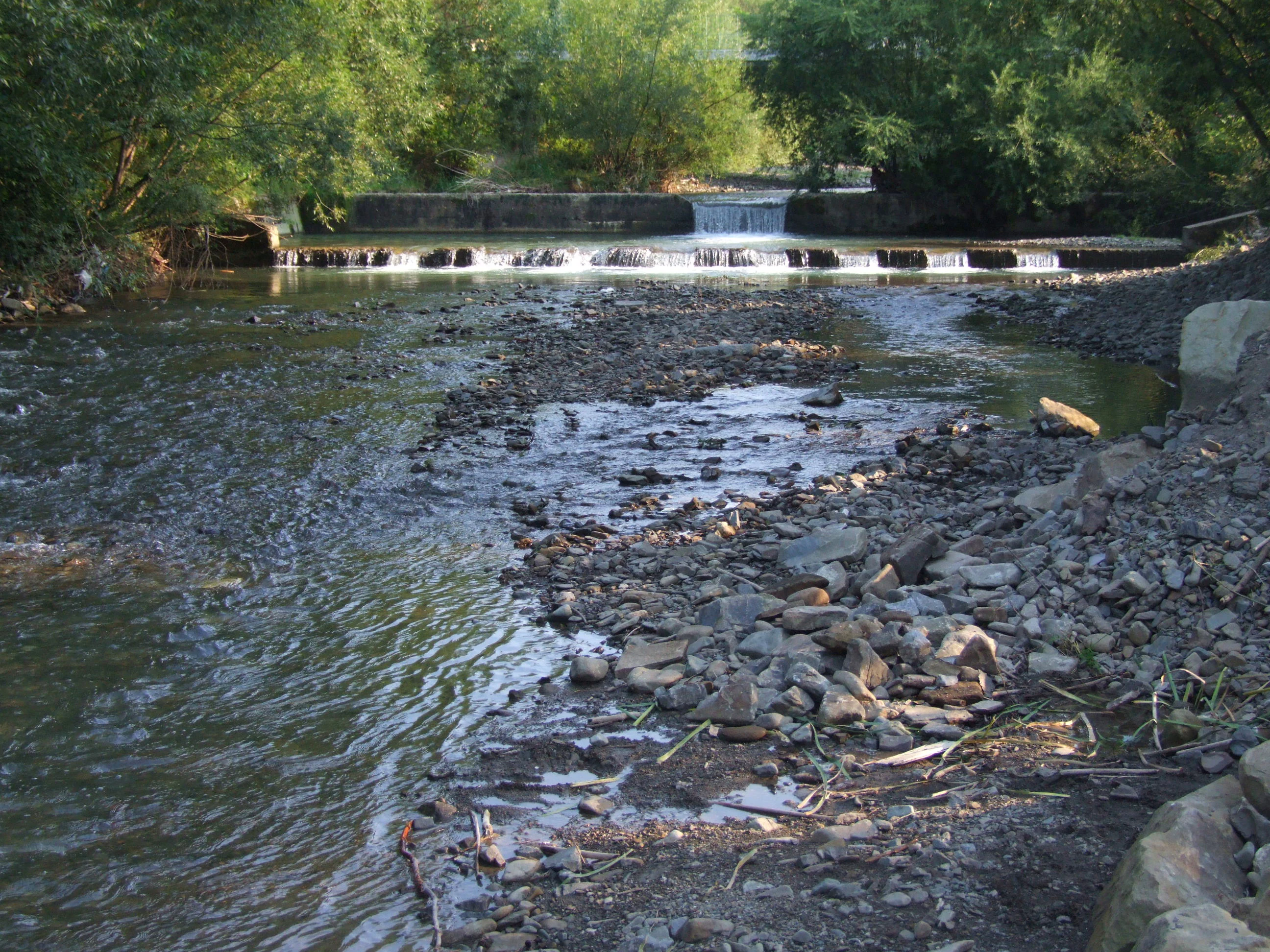
A small river with rocky banks flowing toward a low concrete weir under tree cover.
The Jurkowka river flowing through a forested area, featuring a small man-made weir.

Łososina landscape and geographic character

Łososina lies within the Pogórze Rożnowskie, a foothill mesoregion characterized by rolling terrain, dissected valleys, and a dense network of small mountain streams. The protected area is concentrated along sections of these streams and their adjacent valleys rather than on any single elevated landform. The terrain is shaped by watercourses that have deposited gravel, stones, and finer sediments, forming alluvial features such as bars, terraces, and flood-prone flats.

These stream corridors cut through a submontane landscape where slope processes and running water continually rework the bed material. The four enclaves that make up the site reflect the natural fragmentation of habitat along such waterways, with each enclave corresponding to stretches of valley where the riparian system remains in a relatively undisturbed state. The result is a landscape defined less by dramatic relief than by the persistent presence of active streams, gravel beds, and the narrow bands of forest and scrub that line them.

Łososina ecosystems, habitats, and plant life

The ecological identity of Łososina is built around running-water habitats and the vegetation communities that depend on them. The spring-fed and rain-fed mountain streams crossing the site maintain cool, oxygen-rich conditions that support a distinctive aquatic fauna and create the disturbance regimes that shape riparian vegetation.

Along the stream margins, where gravel is regularly moved by high flows, pioneer plant communities colonize freshly exposed sediments. These communities are accompanied by grey willow (Salix) scrub on gravel banks and alluvial deposits, a habitat known in Polish ecological classification as the Salici-Myricarietum type. Where the valley floor widens or stabilizes, more developed floodplain forests appear, including willow, white poplar, alder, and ash communities: the Salicetum albo-fragilis, Populetum albae, and Alnenion glutinoso-incanae types. In places where groundwater emerges at the surface, spring mires with alder contribute additional wet woodland habitat, supporting moisture-loving ground flora and providing stable microclimates along the upper reaches of the streams.

Łososina wildlife and species highlights

The defining wildlife focus of Łososina is Barbus meridionalis, the Mediterranean barbel, a small river fish that requires clean, well-oxygenated stretches of stream with gravel or stony substrates. Its presence at the site is the formal anchor of the area’s conservation designation and reflects the broader health of these foothill streams.

Beyond this signature species, the mosaic of stream, gravel bed, willow scrub, and floodplain forest provides habitat for the wider community of aquatic invertebrates, small bottom-dwelling fish, and riparian birds typical of Carpathian foothill valleys. The willow and alder stands, together with the spring-fed wet zones, offer sheltered conditions for amphibian species and the insects, mollusks, and small vertebrates associated with stable wet woodland.

Łososina conservation status and protection priorities

Łososina is a Special Area of Conservation under the European Union Natura 2000 framework, designated to maintain or restore the favorable conservation status of listed habitat types and species. Its protection strategy is species-led but habitat-based: securing the long-term survival of Barbus meridionalis requires maintaining the natural structure and quality of the streams the fish inhabits, which in turn depends on preserving the surrounding riparian and floodplain habitats.

The fragmented, four-part shape of the site reflects the practical reality of conserving a linear stream system. By protecting multiple connected enclaves along the waterways near Łososina Dolna, the designation aims to safeguard enough contiguous habitat to support viable populations of the Mediterranean barbel and to preserve the natural dynamics of pioneer vegetation, willow scrub, and floodplain forest that characterize these foothill streams.

Top sights and standout views in Łososina

Łososina stands out as a compact, ecologically targeted Natura 2000 site in the Polish Carpathian foothills. Its main distinction is the formal protection of the Mediterranean barbel in a network of foothill streams, paired with a sequence of rare and fragile habitat types.

The site captures an unusually complete cross-section of stream-side habitat: from open gravel pioneer vegetation, through grey willow thickets, to mature willow, poplar, alder, and ash floodplain forest, and finally to spring-fed alder mire. Within the relatively small total area, Łososina offers a concentrated example of how submontane stream valleys can retain natural structure in a largely agricultural region.

Monthly climate preview

Track representative monthly weather data and average temperature patterns across the year

Łososina Climate Normals, Long-Term Temperature and Precipitation Rhythms

Long-term NASA measurements establish the baseline annual temperature and daily precipitation rhythm recorded at a representative coordinate within Łososina. Reviewing the full monthly sequence provides deeper context on historical weather patterns across the protected landscape.
Annual mean8 °C
-3 °C20 °C
Jan-3°
Feb-2°
Mar
Apr
May14°
Jun18°
Jul20°
Aug20°
Sep14°
Oct
Nov
Dec-2°
Warmest month
July

19.8 °C

Coolest month
January

-3.3 °C

Wettest month
July

3.4 mm/day

Driest month
December

1.3 mm/day

Park location guide

Geography guide, regional context, and park location map for Łososina

Łososina park geography, regions, and map view in Poland

Understand where Łososina sits in Poland through a broader geographic reading of the surrounding landscape, nearby location context, and its mapped position within the national park landscape.

How Łososina fits into Poland

Poland, officially the Republic of Poland, is a Central European country spanning from the Baltic Sea in the north to the Carpathian Mountains in the south. It borders Germany, Czech Republic, Slovakia, Ukraine, Belarus, Lithuania, and Kaliningrad Oblast. The country has a temperate climate, diverse landscapes, and is known for its rich history, cultural heritage, and strong economic position within the EU.

Wider geography shaping Łososina in Poland

Poland occupies 312,696 km2 in Central Europe, extending from the Baltic Sea coast in the north to the Sudetes and Carpathian Mountains in the south. It borders Germany to the west, Czech Republic and Slovakia to the south, Ukraine and Belarus to the east, and Lithuania and Kaliningrad Oblast to the northeast. The landscape includes lowland plains, uplands, and mountain ranges.

Map view of Łososina

Use this park location map to pinpoint Łososina in Poland, understand its exact geographic position, and read its mapped placement within the surrounding landscape more clearly.

Pigeon | © OpenStreetMap contributors

Location context for Łososina

Lesser Poland Voivodeship

Explore protected area views, river valleys, and stream-side terrain across Łososina

Łososina Photos and Scenery: Visualizing Carpathian Foothill Habitats

Visual records capture the distinctive submontane terrain, active mountain streams, and alluvial floodplains that define the protected landscape of Łososina. Examining these natural habitats provides a clearer understanding of the ecological features supporting local freshwater ecosystems.

A small river with rocky banks flowing toward a low concrete weir under tree cover.

Park atlas

Compare adjacent Carpathian foothill reserves and riparian valley habitats.

Explore Parks Near Łososina and Surrounding Protected Areas

Browse protected areas near Łososina to examine similar submontane stream corridors and alluvial landscapes across the region. Regional park comparisons reveal wider ecological patterns within the surrounding Carpathian foothills.
Protected areaLesser Poland Voivodeship
About 8.7 km away#1 closest

South

Środkowy Dunajec z dopływami: Protected River Habitats and Carpathian Foothills Geography

Exploring the river corridor and riparian ecosystems of southern Poland

Spanning 755 hectares across four connected enclaves, Środkowy Dunajec z dopływami protects the vital riverine systems of the middle Dunajec and its tributaries. This site offers a unique look at the fluvial processes and biodiversity of Carpathian mountain streams, showcasing diverse habitat structures from pioneer gravel banks to mature riparian forests.

Area
7.56 km²
Relief
Upland
Scope
Terrestrial
Water
Major water bodies
Protected areaLesser Poland Voivodeship
About 10 km away#2 closest

East

Ostoje Nietoperzy okolic Bukowca: Geography and Protected Area Overview

A forest and cave sanctuary in the Lesser Poland Voivodeship.

This protected area represents an ecologically coherent network of forest habitats and hibernation sites across the Pogórze Rożnowskie. It preserves Carpathian woodland remnants and essential roosting environments, offering a detailed look at micro-scale landscape conservation and geological formations like Diabla Dziura in the Polish countryside.

Area
5.863 km²
Established
2008
Relief
Upland
Climate
Temperate
A pale, minimalist watercolor painting featuring soft green hills, grassy foreground, and faint pink mountains in the distance against a white background.
Nature reserveLesser Poland Voivodeship
About 14 km away#3 closest

East

Diable Skały Nature Reserve: Geological Formations in Lesser Poland Voivodeship

Sandstone rock city and protected tectonic cave system

Situated in the Carpathian foothills, Diable Skały Nature Reserve features a striking assembly of coarse-grained Ciężkowice sandstone. The area serves as a vital protected habitat, marked by isolated rock towers and the significant Diabla Dziura cave, offering a concentrated look at the unique geological and ecological character of the Lesser Poland region.

Area
0.161 km²
Established
1953
Relief
Upland
Climate
Temperate
A watercolor painting of a panoramic landscape featuring green forests, a rocky outcrop on the right, and soft rolling hills in the background against a white background.
Protected landscapeLesser Poland Voivodeship
About 18 km away#4 closest

East

Ciężkowicko-Rożnowski Park Krajobrazowy: Geological Features and Protected Foothill Terrain

An Essential Protected Landscape in Lesser Poland Voivodeship

Ciężkowicko-Rożnowski Park Krajobrazowy spans the rolling hills of the Pogórze Rożnowskie and Pogórze Ciężkowickie. This protected area showcases a complex geography of sandstone crags, xerothermic grasslands, and old-growth forest remnants. Its map highlights a dense network of geological monuments, mineral water springs, and deep stream valleys that define this distinctive Małopolska landscape.

Area
182.472 km²
Established
1995
Relief
Upland
Climate
Temperate
Protected landscapeLesser Poland Voivodeship
About 19 km away#5 closest

Northwest

Wiśnicko-Lipnicki Park Krajobrazowy: Atlas and Geography of the Carpathian Foothills

Mapped sandstone outcrops and diverse protected habitats

Wiśnicko-Lipnicki Park Krajobrazowy defines the transition between open agricultural lowlands and forested Carpathian ridges. Within its boundaries, geologic erosion has carved deep stream ravines and isolated mushroom-shaped sandstone tors, while the valley floors host moisture-rich peat bogs and grasslands. This protected area offers a compelling look at the integrated natural and cultural heritage typical of the southern Polish landscape.

Area
142.308 km²
Established
1997
Relief
Upland
Climate
Temperate
Protected areaLesser Poland Voivodeship
About 23 km away#6 closest

Southeast

Łabowa Protected Area: Forested Carpathian Foothills and Riparian Habitats in Lesser Poland

A key Natura 2000 site protecting mountain stream ecosystems and forest diversity

Located in the Lesser Poland Voivodeship, Łabowa is a significant protected area known for its continuous forest cover and diverse stream-influenced terrain. Spanning over 3,000 hectares, this site offers deep insight into the ecological character of the Carpathian foothills and the preservation of habitat for sensitive bat species.

Area
33.04 km²
Relief
Mountain
Water
Major water bodies
Protected areaLesser Poland Voivodeship
About 25 km away#7 closest

South

Ostoja Popradzka: Mapped Protected Landscapes and Geographic Context in Southern Poland

A core conservation site within the Beskid Sadecki mountain range

Spanning extensive river valleys and alpine meadows, Ostoja Popradzka serves as a primary habitat network in the Polish Carpathians. This entry details its layered geography, including protected forest reserves, karst cave systems, and essential corridors for large carnivores, framed within the administrative boundaries of the Lesser Poland Voivodeship.

Area
579.31 km²
Established
2008
Relief
Mountain
Scope
Terrestrial
Nature reserveLesser Poland Voivodeship
About 27 km away#8 closest

West

Uroczysko Łopień Nature Reserve: Geography and Protected Habitat Mapping

Beskid Wyspowy mountain landscape and karst cave systems

Uroczysko Łopień represents a concentrated protected landscape within the Beskid Wyspowy, defined by its complex geology, primeval beech forests, and essential bat hibernation caves. The reserve showcases a remarkable density of micro-habitats, including raised peat bogs and sandstone rock formations, providing an essential study in Carpathian mountain conservation geography.

Area
0.445 km²
Relief
Mountain
Climate
Temperate
Access
Highly restricted

Common questions about visiting, size, designation, and location context for Łososina

Łososina FAQs for park facts, access, geography, and protected area context

Find quick answers about Łososina, including protected-area facts, park geography, trail and visitor context, and how the park fits into its surrounding country and regional landscape.
MoriAtlas Explorer

Continue Your Protected Areas Search Across the Global Atlas

Deepen your exploration by continuing the structured search for national parks and protected areas worldwide. Utilize the comprehensive filtering capabilities to compare different conservation landscapes and refine your understanding of global park geography. Discover more about the distribution and characteristics of protected natural areas.

Global natural geography