

Mori Atlas logo
Nature reserveLüntener Fischteiche

Mapping the ecological intersection of Münsterland heath, pine forest, and wetlands

Lüntener Fischteiche Nature Reserve: A Detailed Geographic Atlas of Protected Border Landscapes

(Naturschutzgebiet Lüntener Fischteiche)

Lüntener Fischteiche represents a vital conservation zone within the Münsterland region of North Rhine-Westphalia, where historical heath pond landscapes persist against a backdrop of managed pine forest. This protected area acts as a crucial link in a cross-border ecological corridor, encompassing open water, damp bog margins, and rare stands of old juniper. By examining the mapped terrain and boundaries, users can understand the reserve as a core component of the wider western Münsterland mire and heath conservation network.

nature reserveheathlandbogpine forestpondswaterbirds
A stylized vector illustration of a forest landscape with a pond in the foreground, evergreen and birch trees, and distant hills under a sunset sky.

Lüntener Fischteiche

Nature reserve

Park overview

Structured park overview, official facts, and landscape profile for Lüntener Fischteiche

Lüntener Fischteiche park facts, protected area profile, and essential visitor context

Review the core facts for Lüntener Fischteiche, including designation, size, terrain, visitor scale, habitats, and operating context in one park-focused overview.

About Lüntener Fischteiche

Lüntener Fischteiche is a compact nature reserve in the western Münsterland region of North Rhine-Westphalia, situated where the intensively cultivated lowlands of the German-Dutch border meet one of the last local remnants of a heath and mire landscape. The reserve covers about one hundred hectares and is centered on a chain of ponds that originated when local streams were dammed to form a heath pond (Heideweiher). That pond system is now the focal feature of a protected area whose ecological character reflects centuries of interaction between local land use and the wet, sandy soils of the region.

Historically the ponds were used for intensive fish farming until 1952, a use that shaped their hydrology and shoreline vegetation. When protection arrived in 1958, the site was already recognizable as a place where older bog and heath species had persisted despite forest planting around them. The surrounding matrix of pine forest is itself partly an artifact of past land management, yet the open water and damper zones within it retain a distinctive assemblage of mire plants. Some older juniper trees survive in the protected area, lending an extra note of age to the landscape that would otherwise appear largely as pine plantation.

The reserve's significance extends beyond its own boundaries. It lies at the edge of a network of protected sites that together preserve the broader western Münsterland heath landscape. The EU Birds Directive protection area "Moore und Heiden des westlichen Münsterlandes" crosses both sides of the border, and Lüntener Fischteiche contributes directly to that designation. This dual status, as both a German nature reserve and a component of a larger European ecological network, gives the site relevance beyond its modest size, anchoring its place in regional conservation strategy.

Quick facts and research context for Lüntener Fischteiche

Lüntener Fischteiche is a nature reserve (Naturschutzgebiet) administered under the code BOR-034 by the district of Borken. It lies near the village of Lünten, northwest of Vreden, immediately on the German-Dutch border, and covers approximately one square kilometer of habitat mosaic.

The official NRW nature-reserve ID is BOR-034, and the site appears in the World Database on Protected Areas under ID 318753. It is also part of the Natura 2000 network and lies within the EU Birds Directive protection area known as "Moore und Heiden des westlichen Münsterlandes". The area is classified as an IUCN Category IV habitat/species management area.

Protection and recognition

Examine documented protection metrics and official international recognition records.

Lüntener Fischteiche Protection Status and International Recognition Data

Examine the verified protection status and administrative designation records established for Lüntener Fischteiche within global conservation databases. Access structured details covering recorded international recognition sources and baseline management metrics without external assumptions.

Protection details

WDPA ID
318753
Park context

Deeper park guide and search-rich context for Lüntener Fischteiche

Lüntener Fischteiche history, landscape, wildlife, and travel context

Explore Lüntener Fischteiche through its history, landscape character, ecosystems, wildlife, conservation priorities, cultural context, and seasonal travel timing in a structured park guide built for atlas discovery and search intent.

Why Lüntener Fischteiche stands out

The reserve is best known as one of the rare surviving examples of an old heath pond landscape in western Münsterland, where fragments of former bog and heath habitat persist within a broader pine forest. It is recognized particularly for the unusual co-occurrence of open heath water, damp bog flora, and older juniper trees in a small but ecologically rich borderland setting. It is also notable as a bird protection site: alongside the adjacent Lüntener Wald and Ammeloer Venn reserves, Lüntener Fischteiche contributes to a cross-border corridor of bird habitat that has been formally designated under the EU Birds Directive.
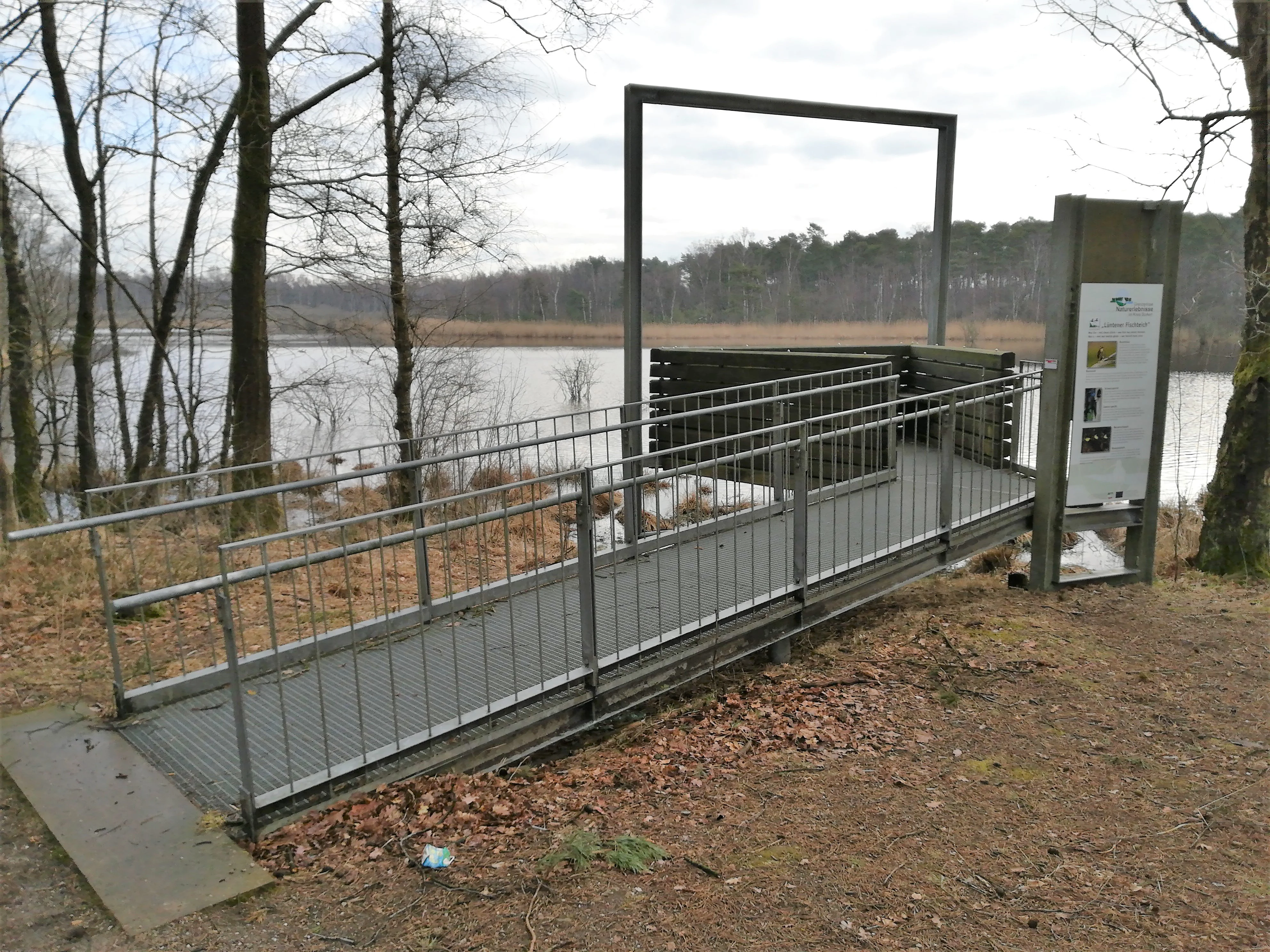
A metal ramp and viewing platform with information signage, set in a forest overlooking a pond.
A metal viewing platform overlooking the water at Lüntener Fischteiche.

Lüntener Fischteiche history and protected-area timeline

The pond system at Lüntener Fischteiche began as an impounded heath pond in a landscape previously dominated by open heath and bog. For generations it was managed for intensive fish farming, with fish culture continuing until 1952. The pressures of this commercial use shaped the shoreline, water levels, and vegetation around the ponds for many decades.

In 1958 the area was officially placed under protection as a nature reserve, marking a decisive shift away from intensive management toward ecological preservation. A later recognition followed when the reserve was incorporated into the larger EU Birds Directive protection zone focused on the moors and heaths of the western Münsterland, giving the site a formal role in European conservation policy.

The reserve has since functioned as part of a broader network of protected sites in the district of Borken and across the German-Dutch border. Its administrative designation remained under district-level management, and the area today retains much of the dual character established during its transition from working fish ponds to conservation area.

Lüntener Fischteiche landscape and geographic character

The landscape of Lüntener Fischteiche is shaped by a central pond system set within a flat, low-lying border environment. Elevation across the reserve runs only from around 41 meters at the higher edges down to about 38 meters, reflecting the gentle topography typical of the western Münsterland. The visual impression is one of still water edged by pines, with clearer open shorelines in some sectors and denser forest cover elsewhere.

Historically the surrounding country was an open heath and bog landscape. Today, much of that setting has been replaced by planted pine forest, but the effects of the older land use still mark the terrain. The pond basins and their immediate margins preserve hints of the former heath pond character, while scattered older juniper trees add a layer of structural variety to the woodland. The result is a modest but ecologically textured scene, with alternating zones of open water, damp shore, and closed canopy forest.

The reserve does not present dramatic landforms. Its character lies instead in the subtle interplay between a still-water core, boggy margins, and an expanse of older pine forest, all pressed against the international border. The flat adjacent landscapes of the Netherlands extend this character westward, while the wider view to the east quickly transitions into the agricultural countryside of the Münsterland.

Lüntener Fischteiche ecosystems, habitats, and plant life

The reserve centers on a habitat mosaic that combines open water, wet heath, and mire communities within a larger cover of pine forest. This combination is unusual in the intensively used western Münsterland, where most traces of the original heath and bog landscape have been lost. The protected area preserves fragments of those older ecosystems, allowing characteristic species to persist in a setting where they would otherwise be absent.

The wet habitats around the ponds support a notable assemblage of mire plants. Among the species documented in this habitat mosaic are marsh St John's wort (Sumpf-Johanniskraut), marsh clubmoss (Sumpf-Bärlapp), and the small bladderwort known as lesser bladderwort (Kleiner Wasserschlauch), all species adapted to acidic, nutrient-poor wet conditions. Their continued presence indicates that parts of the older bog flora have survived the long history of fish farming and forest planting.

The pine forest itself is largely planted, but the stands are varied enough in age and structure that some sections approach a more heterogeneous woodland character. The presence of older juniper trees is particularly striking, since junipers indicate continuity with the earlier open heath landscape rather than the more recent forestry era. Together these habitat types form the ecological backbone of the site.

Lüntener Fischteiche wildlife and species highlights

The reserve's wildlife interest is closely tied to its combination of still water, wet margins, and sheltered forest edge. The pond is regularly used by waterbirds, with species such as the Eurasian teal (Krickente) recorded among the breeding or visiting waterfowl. The little grebe (Zwergtaucher) is also noted as a resident species of the pond.

The site functions as one component of a larger bird protection zone. Its formal inclusion in the EU Birds Directive area "Moore und Heiden des westlichen Münsterlandes" reflects the broader ornithological value of its habitat mosaic, extending well beyond the few species named in the reserve itself. In practical terms, the reserve contributes nesting, resting, and feeding habitat to the bird populations moving through the borderland between Germany and the Netherlands.

Beyond birds, the wet habitats and forest mosaic provide refuges for invertebrates and smaller fauna typical of bog and heath environments, although detailed records focus most clearly on the waterbird component. The reserve's modest size limits its role as a large mammal habitat, but for smaller species and ecologically sensitive wet-loving groups the area continues to be regionally important.

Lüntener Fischteiche conservation status and protection priorities

The primary conservation significance of Lüntener Fischteiche lies in its preservation of rare habitat types within a heavily modified regional landscape. Western Münsterland has lost most of its original heath and mire, so even a small surviving fragment has disproportionate value. The reserve's mosaic of open water, wet heath, and pine forest with junipers represents a working example of how legacy habitats can be retained alongside newer forest cover.

The site also carries formal European recognition. It is part of the EU Birds Directive protection area "Moore und Heiden des westlichen Münsterlandes", which spans the broader western Münsterland region. This status places the reserve within a transnational framework for bird conservation and reinforces its role as a node in a network of cross-border protected areas.

At the German state level, the reserve is designated under the NRW protected-area system with the identifier BOR-034, and appears in international databases such as the World Database on Protected Areas. Its IUCN Category IV classification reflects its role as a habitat and species management area, where protection is actively directed at maintaining particular ecological features rather than leaving the landscape entirely to natural processes.

Top sights and standout views in Lüntener Fischteiche

The standout features of Lüntener Fischteiche include the surviving heath pond itself, the patches of older bog and heath vegetation within a pine-dominated forest matrix, and the notable presence of older juniper trees that connect the present landscape to its open-heath past. The reserve also stands out for its location directly on the German-Dutch border, making it a literal and ecological link between two national conservation landscapes.

Visitors will also find the reserve connected into regional cycling networks, with the Flamingoroute and other themed cycle paths passing the site, and a small viewing platform offering a vantage point over the larger pond. Nearby reserves such as Lüntener Wald and Ammeloer Venn extend the conservation story westward, so the site functions as much as a gateway to a larger borderland habitat network as it does a destination in its own right.

Best time to visit Lüntener Fischteiche

The reserve can be enjoyed year-round, but the character of a visit depends strongly on the season. Spring and the early part of the year typically bring the most active birdlife at the pond, when waterfowl are most visible and the wet heath vegetation begins to develop. The open water and shoreline are easiest to observe from the viewing platform on the western edge of the larger pond during these months.

Summer offers the fullest expression of the wetland and heath vegetation, when the bog and heath plants around the pond are in active growth and the surrounding pine forest provides cool shade. Autumn deepens the colors of the heath flora and the forest edge, while winter brings quieter conditions, when frost and mist can highlight the open character of the pond and forest mosaic. The boardwalk across the reserve can be slippery in wetter periods, so drier seasons are generally easier for walking.


Monthly climate preview

Long-term representative monthly averages and temperature ranges for Lüntener Fischteiche

Lüntener Fischteiche Climate Normals, Annual Temperature and Precipitation Rhythm

Lüntener Fischteiche records measured monthly climate norms spanning long-term average minimum and maximum temperatures alongside daily precipitation rates. Examining the complete twelve-month temperature and precipitation sequence reveals detailed annual weather patterns across the representative park coordinate.
Annual mean10 °C
2 °C18 °C
Jan
Feb
Mar
Apr
May13°
Jun16°
Jul18°
Aug18°
Sep15°
Oct10°
Nov
Dec
Warmest month
July

18.4 °C

Coolest month
January

1.6 °C

Wettest month
December

2.5 mm/day

Driest month
April

1.5 mm/day

Park location guide

Geography guide, regional context, and park location map for Lüntener Fischteiche

Lüntener Fischteiche park geography, regions, and map view in Germany

Understand where Lüntener Fischteiche sits in Germany through a broader geographic reading of the surrounding landscape, nearby location context, and its mapped position within the national park landscape.

How Lüntener Fischteiche fits into Germany

Germany is a federal republic in Western and Central Europe with a population of over 83 million across sixteen constituent states. It is Europe's largest economy by nominal GDP and a major global exporter and importer. The capital is Berlin, and the country borders Denmark, Poland, Czech Republic, Austria, Switzerland, France, Luxembourg, Belgium, and the Netherlands.

Wider geography shaping Lüntener Fischteiche in Germany

Germany is located in Western and Central Europe, spanning 357,022 km². It borders Denmark to the north, Poland and the Czech Republic to the east, Austria and Switzerland to the south, and France, Luxembourg, Belgium, and the Netherlands to the west. The country has coastlines on the Baltic Sea and North Sea to the north, with the Alps located in the southern region.

Map view of Lüntener Fischteiche

Use this park location map to pinpoint Lüntener Fischteiche in Germany, understand its exact geographic position, and read its mapped placement within the surrounding landscape more clearly.

Pigeon | © OpenStreetMap contributors

Location context for Lüntener Fischteiche

North Rhine-Westphalia

Explore protected habitats, heath ponds, and pine forest scenery in western Münsterland.

Lüntener Fischteiche Photos and Landscapes: Visualizing the Border Reserve

Visual documentation captures the flat terrain, still pond waters, and surviving bog remnants defining the protected environment of Lüntener Fischteiche. Photographic records reveal the subtle interplay between open water margins and older pine forest along the German-Dutch border.

A metal ramp and viewing platform with information signage, set in a forest overlooking a pond.

A calm, still pond surrounded by golden brown marshland and thin, leafless trees under a cloudy sky.

Park atlas

Compare adjacent border reserves and regional habitat networks

Parks Near Lüntener Fischteiche and Surrounding Protected Landscapes

Browsing other protected areas near Lüntener Fischteiche reveals the broader network of cross-border mire and forest reserves spanning the German and Dutch borderlands. Comparing these adjacent conservation sites offers valuable context on the surviving heath and wetland ecosystems characteristic of the western Münsterland.
Nature reserveOverijssel
About 2.8 km away#1 closest

Northeast

Witte Veen Nature Reserve: Mapped Protected Landscapes and Bog Terrain in Overijssel, NL

Regional peatland geography and cross-border conservation status

Witte Veen is a protected nature reserve in eastern Overijssel, known for its distinct raised bog habitat and active restoration efforts. This site forms an essential link in the Dutch-German border chain, offering a unique look at fragmented wetland terrain, bog pools, and heathland ecosystems managed for ecological recovery.

Area
2.9 km²
Established
2013
Relief
Lowland
Climate
Temperate
Nature reserveNordrhein-Westfalen
About 9.2 km away#2 closest

Southwest

Moore und Heiden des westlichen Münsterlandes Nature Reserve: Regional Protected Landscapes

Bog and heathland geography in western North Rhine-Westphalia

The Moore und Heiden des westlichen Münsterlandes nature reserve is a vital complex of peatlands, wet meadows, and bog woodlands situated in western Germany. This site offers a unique geographic study of restored hydrology and open moorland, providing critical habitats for rare waders and the northernmost breeding colony of Greater Flamingo in Europe.

Area
23 km²
Established
1983
A soft, light watercolor painting of a serene marshy landscape with green hills, lush vegetation, and pink flowers in the foreground.
Nature reserveNordrhein-Westfalen
About 9.4 km away#3 closest

Southwest

Krosewicker Grenzwald Nature Reserve: Protected Woodland and Border Geography Atlas

Münsterland nature reserve with cross-border habitat significance

Krosewicker Grenzwald is a rare island of woodland set within the intensely cultivated agricultural plains of the western Münsterland. This nature reserve, straddling the German-Dutch border, supports specialized birch and pipegrass communities while functioning as a critical component of the broader Natura 2000 conservation framework.

Area
0.074 km²
Established
1985
IUCN
IV
Nature reserveOverijssel
About 18 km away#4 closest

North

Landgoed Lonnekermeer Nature Reserve: Geographic Landscape and Protected Area Mapping

Twente region, Overijssel province, Netherlands

Landgoed Lonnekermeer is a 98 hectare nature reserve in Overijssel characterized by a designed early twentieth century landscape, lakes originating from historic sand quarries, and expansive wet heath. Explore the protected boundaries of this estate as it serves as a living model for habitat restoration, showcasing the successful recovery of local fens, brooks, and biodiversity-rich hay meadows within the eastern Netherlands.

Area
1.05 km²
Established
1902
Relief
Lowland
Climate
Temperate
Nature reserveGelderland
About 19 km away#5 closest

Southwest

Korenburgerveen Nature Reserve: Geography and Protected Peatland Landscapes in Gelderland

A vital wetland and raised bog complex in the Dutch Achterhoek

Korenburgerveen represents a key protected peatland basin in Gelderland, featuring a diverse mosaic of marsh woodland, blue grassland, and active raised bog. Use this geographic entry to analyze the reserve's position within the wider Nationaal Landschap Winterswijk and observe the hydrological restoration of its rare wetland terrain.

Relief
Lowland
Climate
Temperate
Scope
Terrestrial
Water
Major water bodies
Nature reserveNetherlands
About 23 km away#6 closest

South

Wooldse Veen Nature Reserve: Mapped Geography and Protected Bog Landscapes in the Netherlands

A transboundary peatland system in Gelderland.

Wooldse Veen preserves a rare fragment of raised bog and peatland habitat in the Dutch-German borderlands. The reserve features restored bog pools, historic smugglers paths, and a mosaic of heathland and birch woodland that reflects the regional geography of the Winterswijk National Landscape.

Area
1.5 km²
Established
1949
Relief
Lowland
Climate
Temperate
A soft watercolor painting of a green meadow landscape with a small pond, cattails, and gentle forested hills in the background.
Nature reserveOverijssel
About 24 km away#7 closest

North

Landgoederen Oldenzaal: Mapping the Protected Estate Forests of Overijssel

Nature reserve geography and habitat connectivity in Twente

Landgoederen Oldenzaal comprises a series of historical estates at the foot of the Oldenzaal ice-pushed ridge. The landscape is characterized by mature woodland complexes, spring-fed brooks, and a traditional field pattern that persists today. As a protected Natura 2000 site, it demonstrates successful habitat reconnection through specialized infrastructure within the wider Twente region.

Area
5.78 km²
Established
2013
Relief
Upland
Climate
Temperate
Nature reserveGelderland
About 24 km away#8 closest

West

Stelkampsveld Protected Nature Reserve and Restored Achterhoek Kampenlandschap in Gelderland

Tracing the mapped boundaries of historic heath and fen ecosystems

Stelkampsveld acts as an ecologically distinctive protected area in the eastern Netherlands. Covering 102 hectares, the terrain showcases a recovered mosaic of hedgerows, small enclosed fields, and re-established wetlands. The site is recognized for its botanical diversity, including rare orchid and moss species within the broader Natura 2000 network of Gelderland.

Area
1.02 km²
Established
2013
Relief
Lowland
Climate
Temperate

Common questions about visiting, size, designation, and location context for Lüntener Fischteiche

Lüntener Fischteiche FAQs for park facts, access, geography, and protected area context

Find quick answers about Lüntener Fischteiche, including protected-area facts, park geography, trail and visitor context, and how the park fits into its surrounding country and regional landscape.
MoriAtlas Explorer

Continue Your Protected Areas Search Across the Global Atlas

Deepen your exploration by continuing the structured search for national parks and protected areas worldwide. Utilize the comprehensive filtering capabilities to compare different conservation landscapes and refine your understanding of global park geography. Discover more about the distribution and characteristics of protected natural areas.

Global natural geography