Why MacArthur Landing Memorial National Park stands out
MacArthur Landing Memorial National Park is best known for its seven life-sized bronze statues that depict General Douglas MacArthur wading ashore at Red Beach accompanied by key members of his entourage, including President-in-exile Sergio Osmeña, Lieutenant General Richard Sutherland, Brigadier General Carlos P. Romulo, Major General Courtney Whitney, Sergeant Francisco Salveron, and CBS Radio correspondent William J. Dunn. The statues were designed by Filipino sculptor Anastacio Caedo and inaugurated in 1981 during the 37th anniversary of the landing. The memorial preserves the exact location where MacArthur fulfilled his 1942 promise to return to the Philippines, making it one of the most significant World War II memorial sites in the country and a symbol of the Allied liberation campaign.
MacArthur Landing Memorial National Park history and protected-area timeline
The historical significance of this site traces to October 20, 1944, when General Douglas MacArthur fulfilled his pledge made two years earlier upon leaving the Philippines for Australia. After the Japanese occupation began in 1942, MacArthur departed with the famous promise to return, and the Leyte landing represented the first major step in the campaign to liberate the Philippine archipelago. The landing at Red Beach, named for the codename assigned by the US Sixth Army to the stretch of coastline from Marasbaras to Palo, encountered sporadic enemy fire but proceeded successfully. Following the landing, MacArthur spent four days visiting different beaches while establishing the restored Filipino government and securing the foothold necessary for the broader liberation campaign. The memorial park was originally named Imelda Park after former First Lady Imelda Marcos, who hails from Leyte Province. It was declared a national park on July 12, 1977, and the statues were inaugurated during the 37th anniversary of the landing in 1981. The site was declared a national historic landmark by the National Historical Commission of the Philippines in 1994, coinciding with the 50th anniversary of the landing and the inauguration of the Rock Garden of Peace. In November 2013, Typhoon Haiyan, one of the strongest recorded supertyphoons, damaged the memorial, knocking the Carlos P. Romulo statue from its base, though restoration was completed within twenty days.
MacArthur Landing Memorial National Park landscape and geographic character
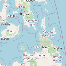
The park occupies a flat coastal plain along the shores of Leyte Gulf, in an area characterized by the shallow waters that made the 1944 landing challenging and necessitated the famous wading scene captured in photographs. The memorial sits on a 6.78-hectare site in the barangay of Candahug, facing the waters where American forces came ashore. The landscape features a manmade pool surrounded by the bronze statue installations, with the broader area including the Rock Garden of Peace and memorial structures. The coastal setting provides views across Leyte Gulf toward the larger island landscape of Eastern Visayas. The surrounding municipality of Palo serves as a regional government center, with the park situated within a developed area that includes nearby hotels and facilities rather than a remote wilderness setting.
MacArthur Landing Memorial National Park ecosystems, habitats, and plant life
As a historical memorial site rather than an ecological preserve, the park's natural environment reflects its coastal plain setting on Leyte Island rather than significant biodiversity or habitat conservation. The primary focus of protection and visitation centers on the historical and cultural significance of the World War II landing site rather than natural ecosystems. The park's small area of 6.78 hectares does not constitute a major ecological habitat, and the developed nature of the memorial and surrounding area means the natural landscape serves primarily as the historical backdrop for the commemoration rather than as a primary conservation focus.
MacArthur Landing Memorial National Park wildlife and species highlights
The park does not contain significant wildlife populations or notable wildlife viewing opportunities, as it functions primarily as a historical memorial rather than a nature preserve. The coastal setting may support common coastal bird species and marine life typical of Leyte Gulf, but the site's significance lies in its historical importance rather than wildlife conservation or observation. Visitors come to the park for its military history and memorial value, not for wildlife-related activities.
MacArthur Landing Memorial National Park conservation status and protection priorities
The park was established as a national park in 1977 to preserve the historic landing site and commemorate the liberation of the Philippines during World War II. While the conservation focus differs from ecological parks, the protected status ensures the preservation of this historically significant location and its associated memorial structures. The designation as a national park by the Philippine government through the Department of Environment and Natural Resources provides institutional protection for the site and its maintenance as a public memorial. The additional designation as a national historic landmark by the National Historical Commission of the Philippines in 1994 further reinforced the site's protected status and importance for preservation.
MacArthur Landing Memorial National Park cultural meaning and human context
The MacArthur Landing Memorial National Park represents a significant intersection of Philippine and American military history, commemorating the Allied liberation campaign that ended Japanese occupation during World War II. The memorial honors both American military leadership and Filipino political figures who participated in the return to Philippine soil, including President-in-exile Sergio Osmeña. The site holds particular significance in the Philippines as a symbol of the restoration of sovereignty and the role of American forces in the liberation, while also representing a complex chapter in the bilateral relationship between the two nations. The annual memorial rites and reenactments held at the park draw veterans, their families, and dignitaries, maintaining an active commemorative tradition that connects contemporary visitors to this pivotal historical moment. The local community in Palo and the broader Eastern Visayas region maintain strong ties to the memorial as part of their regional identity and historical heritage.
Top sights and standout views in MacArthur Landing Memorial National Park
The seven bronze statues depicting General MacArthur and his entourage constitute the park's most distinctive visual feature, capturing the historic landing moment in permanent form. The adjacent museum provides additional context through historic photographs, memorabilia, and interpretive displays including a copy of MacArthur's landing speech and his bronze footprint cast. The annual commemoration ceremonies and reenactments offer visitors the opportunity to experience living history at the actual site. The designation as a national historic landmark in 1994 adds institutional recognition to the site's importance, while the Rock Garden of Peace provides a contemplative space within the memorial complex. The park's location in Palo, near Tacloban, makes it accessible for visitors exploring Eastern Visayas and provides a foundation for understanding the broader World War II history of the region.
Best time to visit MacArthur Landing Memorial National Park
The best time to visit MacArthur Landing Memorial National Park corresponds to the dry season in the Eastern Visayas region, typically from November through May, when rainfall is reduced and visitors can comfortably explore the outdoor memorial grounds. The park can be visited year-round, but the wet season from June to October may bring heavy rains and occasional storms that could affect travel plans and outdoor exploration. Those interested in attending the annual memorial ceremonies may find the October anniversary period particularly meaningful, though this coincides with the tail end of the wet season. The proximity to Tacloban means that weather conditions in the city directly affect park visits, and travelers should monitor weather forecasts, particularly during typhoon season when the region has experienced significant storms including Typhoon Haiyan in 2013.