Mori Atlas logo
Nature reserveMangere Island

Tracing the geological boundaries and restoration history of this unique volcanic islet

Mangere Island Nature Reserve: Volcanic Landforms and Chatham Islands Conservation Geography

(Mangere Island Nature Reserve)

Mangere Island stands as a dramatic volcanic remnant in the Chatham Islands archipelago, marking the eroded core of a Pliocene-era structure that rises steeply from the Southern Pacific. This protected nature reserve serves as a pioneering site for island restoration, providing a secure sanctuary for rare endemic bird species re-established within its recovering landscape. The island terrain, defined by rugged cliffs and exposed volcanic rock, offers a distinct window into the ecological history and geomorphology of remote New Zealand territories.

nature reservevolcanic islandisland restorationendemic birdsbird reintroductionblack robin

Mangere Island

Nature reserve

Park overview

Structured park overview, official facts, and landscape profile for Mangere Island

Mangere Island park facts, protected area profile, and essential visitor context

Review the core facts for Mangere Island, including designation, size, terrain, visitor scale, habitats, and operating context in one park-focused overview.

About Mangere Island

Mangere Island is one of the more remote and ecologically important islands in the Chatham Islands, a small archipelago scattered across the Pacific east of mainland New Zealand. Although it lies only 45 kilometres from the main settlement of Waitangi on Chatham Island, its distance from the country's South Island and its isolation by open ocean give it a strong sense of remoteness. The island is uninhabited and has no permanent infrastructure, and access is limited and tightly managed as part of its protected status.

The island's physical character is a product of deep geological time. Together with Little Mangere, also known as Tapuaenuku, it forms the eroded core of an ancient Pliocene volcano. Centuries of weathering have reduced what was once a much larger volcanic structure to rugged cliffs and steep terrain, and this geological origin continues to shape the island's profile. Its highest point, Whakapa, reaches 292 metres above sea level, making Mangere the highest island in the immediate group despite covering only around 113 hectares.

Mangere's modern identity is defined primarily by conservation. Once forested, the island was progressively cleared for sheep pasture during the late nineteenth century, and rabbits and cats were introduced along with the livestock. These changes had severe effects on the island's natural systems, and by the mid-twentieth century the ecological damage was clear. The New Zealand government purchased the island in 1966, removed the last sheep shortly afterward, and began a formal restoration programme in 1973. Since then Mangere has been used as a predator-free refuge for rare Chatham Islands birds.

Today the island is recognised as one of the cornerstone sites of New Zealand's offshore island conservation work. It is administered as a Nature Reserve, and its ecological management continues to influence conservation practice across the broader Chatham Islands group.

Quick facts and research context for Mangere Island

Mangere Island lies in the Chatham Islands group, roughly 800 kilometres east of the South Island of New Zealand, and is part of an archipelago that includes the main Chatham Island and Pitt Island. The island covers 113 hectares and rises to 292 metres at Whakapa, its highest point. Geologically, it and Little Mangere are the eroded remnants of an ancient Pliocene-age volcano.

After periods of forest clearance, sheep farming, and the introduction of rabbits and cats, the island was purchased by the New Zealand government in 1966 and later gazetted as a Nature Reserve. Active ecological restoration began in 1973, and the island has since been used as a refuge for several rare and endemic Chatham Islands bird species that have been reintroduced there.

Protection and recognition

Examine the documented conservation framework and territorial designation metrics for Mangere Island.

Mangere Island Protection Status and Terrestrial Conservation Scope

Mangere Island features a documented terrestrial protection scope without imported international recognition sources or transboundary status. Review the registered governance details and designation records associated with this protected landscape.

Protection details

Protection scope
Terrestrial
Transboundary protection
No
Park context

Deeper park guide and search-rich context for Mangere Island

Mangere Island history, landscape, wildlife, and travel context

Explore Mangere Island through its history, landscape character, ecosystems, wildlife, conservation priorities, cultural context, and seasonal travel timing in a structured park guide built for atlas discovery and search intent.

Why Mangere Island stands out

Mangere Island is best known as a pioneering site for island conservation and species reintroduction in the Chatham Islands. It is closely associated with the recovery of the black robin, one of the world's rarest passerines, and with the reintroduction of other endemic Chatham Islands birds such as the Chatham snipe, Chatham tomtit, and shore plover. Geologically, it is also recognised as the eroded core of a Pliocene-era volcano, paired with the smaller nearby islet of Little Mangere. Together, these qualities give Mangere a dual identity as both a geomorphological landmark and a long-term biodiversity reserve.
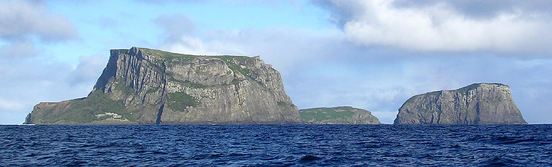
A wide shot from the ocean showing two steep, flat-topped rocky islands with sheer cliffs rising above the deep blue water under a cloudy sky.
A view of Mangere Island, on the left, and Little Mangere Island, on the right, rising from the ocean.

Mangere Island history and protected-area timeline

Mangere Island was historically forested and supported a more diverse ecological community than it does today. From the 1890s onward, the natural cover was progressively cleared to make way for sheep grazing, transforming the island's landscape and vegetation. Together with sheep, rabbits and cats were introduced to the island, and these introduced animals had lasting effects on the native flora and fauna.

The farming era lasted until the mid-twentieth century. In 1966 the New Zealand government purchased the island, ending private agricultural use. It was subsequently gazetted as a Nature Reserve, placing it under formal protection. The last sheep were removed in 1968, clearing the way for ecological recovery.

Active restoration began in 1973 and has continued ever since, making Mangere one of the longest-running island restoration projects in New Zealand. As part of this programme, several rare and endemic Chatham Islands bird species have been reintroduced to the island, including the Chatham snipe in 1970, the black robin in 1976, the Chatham tomtit in 1987, and the shore plover in the 1990s. The success of these reintroductions has given Mangere an important place in the history of New Zealand conservation biology.

Mangere Island landscape and geographic character

Mangere Island is the eroded remnant of a Pliocene-age volcano that once stood much higher above the sea. Over millions of years, weathering and erosion have stripped away the outer portions of the original volcanic structure, leaving a rugged, steep-sided island surrounded by cliffs dropping into the ocean. The neighbouring islet of Little Mangere, sometimes called Tapuaenuku, forms a related fragment of the same original volcano.

The island's terrain is strongly influenced by this volcanic origin. Its highest point, Whakapa, reaches 292 metres above sea level and dominates an island that is otherwise very small, covering only about 113 hectares. The combination of steep slopes, exposed rock, and oceanic exposure gives the island a striking, almost fortress-like appearance, visible clearly from neighbouring Pitt Island only a short distance to the east.

Natural vegetation today is limited and recovering rather than mature forest, reflecting the historical clearing and grazing that shaped the island in the nineteenth and early twentieth centuries. The visual impression is one of low vegetation cover, exposed rock, and a stark coastline, all characteristic of a small, windswept volcanic island in the open Pacific.

Mangere Island ecosystems, habitats, and plant life

Mangere Island belongs to the cool-temperate, wind-swept oceanic ecosystem that characterises much of the Chatham Islands group. Once forested, the island's vegetation was heavily modified by clearing and grazing before conservation intervention, so the present-day flora is in a long phase of regeneration rather than a mature natural state. Restoration efforts have aimed at allowing native plant communities to recover as far as possible from past disturbance.

The island's ecosystems are shaped strongly by isolation and exposure. Surrounded by open ocean and lying in a region with persistent winds, the vegetation tends to be hardy and low-growing. Seabirds have historically been a key element of the island's ecological character, and offshore waters around Mangere and Little Mangere are part of the broader marine environment of the Chatham Islands.

Because the island has been actively managed as a predator-free refuge, it provides a rare opportunity for native species and ecological processes to recover under relatively controlled conditions. This management has made Mangere a valuable reference site for understanding how Chatham Islands ecosystems respond once introduced mammals are removed.

Mangere Island wildlife and species highlights

Mangere Island's modern wildlife identity is centred on rare and endemic Chatham Islands birds. The island has been used as a protected refuge and reintroduction site for several species that were at risk on the larger inhabited islands of the archipelago.

The most famous of these is the black robin, transferred to Mangere in 1976 as part of one of New Zealand's best-known conservation success stories. The Chatham snipe was also introduced to the island in 1970, the Chatham tomtit in 1987, and the shore plover in the 1990s. Together these reintroductions have made Mangere a stronghold for species that exist nowhere else in the world.

Before human arrival, the island would have supported a different ecological community shaped by native forest and the absence of introduced mammals. The decline of that original system through forest clearance, sheep farming, and the spread of rabbits and cats caused major disruption to native wildlife. The ongoing restoration of the island is, in large part, an effort to bring back elements of that original wildlife presence in a secure setting.

Mangere Island conservation status and protection priorities

Mangere Island is one of the most important conservation sites in the Chatham Islands and a significant case study within New Zealand's offshore island management programme. After its purchase by the government in 1966 and removal of sheep in 1968, the island was gazetted as a Nature Reserve, giving it formal legal protection. Ecological restoration began in 1973 and has continued without interruption, making it one of the longest-running island restoration efforts in the country.

The island's conservation value lies in its role as a safe refuge for species threatened on islands where humans, livestock, and introduced predators still have a presence. By transferring vulnerable species to Mangere, conservation managers have been able to establish secure populations away from the main islands. The success of this approach, particularly with the black robin, has shaped conservation thinking not only in the Chatham Islands but across New Zealand.

Mangere's role is also symbolic, as it represents a deliberate shift from nineteenth-century land use, dominated by clearing and farming, to a long-term commitment to biodiversity recovery. The island illustrates how remote, modified land can, with sustained management, be returned to a meaningful conservation role.

Mangere Island cultural meaning and human context

Mangere Island carries two traditional names that reflect the deep cultural history of the Chatham Islands. In the Māori language of the mainland New Zealand settlers, the island is known as Māngere, while in the Moriori language, the indigenous language of the Chatham Islands themselves, it is known as Maung' Rē. The presence of these names in the island's record points to the layered cultural heritage of the Chathams, where both Māori and Moriori traditions are recognised.

The island itself has no permanent population today, and there are no documented communities living on it. Its cultural significance is therefore largely tied to its names, its role in broader Indigenous narratives of the Chathams, and its long history of human use and transformation from forested land to sheep farm to nature reserve.

Top sights and standout views in Mangere Island

The defining highlights of Mangere Island are its volcanic geological origin, its long-running restoration story, and its role as a refuge for rare Chatham Islands birds. The eroded Pliocene volcano, paired with Little Mangere, gives the island a strong and recognisable landform identity that sets it apart from the larger, lower-lying inhabited islands of the archipelago.

Its conservation achievements are equally distinctive. As the site where the black robin's survival was effectively secured, and where several other endemic Chatham Islands birds have been reintroduced, Mangere stands as a landmark location in New Zealand conservation history. The combination of dramatic geology, ecological recovery, and cultural naming heritage makes it a small island with an outsized significance.

Best time to visit Mangere Island

As an uninhabited nature reserve without public tourist infrastructure, Mangere Island is not a conventional visitor destination, and its accessibility is governed by conservation management rather than tourism. The character of any potential visit is shaped by the oceanic climate of the Chatham Islands, where cool temperatures, wind, and changeable weather are constant factors throughout the year.

For those interested in the island's wildlife or restoration work, the breeding and active season for introduced bird populations generally aligns with the milder months of the Southern Hemisphere spring and summer. However, the underlying conditions, including strong winds, exposed terrain, and minimal shelter, are present year-round. The island remains primarily a working ecological site rather than a leisure destination, and any engagement with it is best understood in that context.
Monthly climate preview

Long-term representative monthly temperature and precipitation data for Chatham Islands

Mangere Island Climate Normals and Annual Temperature Rhythm

Representative coordinates track measured annual temperature swings and daily precipitation patterns across the protected reserve. Reviewing the complete twelve-month statistical baseline provides clear context for regional climate variations.
Annual mean12 °C
10 °C15 °C
Jan14°
Feb15°
Mar14°
Apr13°
May12°
Jun11°
Jul10°
Aug10°
Sep10°
Oct10°
Nov11°
Dec13°
Warmest month
February

15 °C

Coolest month
August

9.6 °C

Wettest month
June

3 mm/day

Driest month
January

1.9 mm/day

Park location guide

Geography guide, regional context, and park location map for Mangere Island

Mangere Island park geography, regions, and map view in New Zealand

Understand where Mangere Island sits in New Zealand through a broader geographic reading of the surrounding landscape, nearby location context, and its mapped position within the national park landscape.

How Mangere Island fits into New Zealand

New Zealand is an island nation in the southwestern Pacific Ocean comprising two main islands and numerous smaller islands. Located east of Australia across the Tasman Sea, it features varied topography with the Southern Alps running along the South Island and volcanic terrain on the North Island. The country was settled by Maori people between 1280 and 1350, followed by European exploration beginning in 1642, and became a Dominion in 1907 before gaining full independence in 1947.

Wider geography shaping Mangere Island in New Zealand

New Zealand lies in the southwestern Pacific Ocean, east of Australia across the Tasman Sea. The country consists of two main islands, the North Island and South Island, plus over 600 smaller islands. The North Island features volcanic plateaus and hills while the South Island is dominated by the Southern Alps mountain range. The country has a long coastline and is surrounded by the Pacific Ocean.

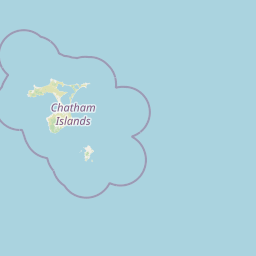
Map view of Mangere Island

Use this park location map to pinpoint Mangere Island in New Zealand, understand its exact geographic position, and read its mapped placement within the surrounding landscape more clearly.

Pigeon | © OpenStreetMap contributors

Location context for Mangere Island

Chatham Islands

Explore photographic records of rugged terrain, coastal cliffs, and recovering habitats in the Chatham Islands.

Mangere Island Photos and Volcanic Landscapes: Visualizing the Protected Island Environment

Visual documentation captures the steep volcanic terrain, exposed rock formations, and stark coastlines defining the protected nature reserve. Examining these landscape views reveals the physical character of the remote island habitat and its enduring conservation geography.

A wide shot from the ocean showing two steep, flat-topped rocky islands with sheer cliffs rising above the deep blue water under a cloudy sky.

Park atlas

Compare nearby volcanic reserves and related island restoration landscapes.

Explore Parks Near Mangere Island and Protected Areas in the Surrounding Region

Browsing other protected areas near Mangere Island reveals broader geographic patterns across the Chatham Islands archipelago. Examining adjacent marine and terrestrial reserves provides essential context for regional conservation initiatives and island bird sanctuaries.
A soft, pastel watercolor painting of a coastal scene with a distant island, grassy slopes, and a calm sea.
Nature reserveChatham Islands
About 13 km away#1 closest

Southeast

Rangatira Island Nature Reserve: Geography and Protected Area Context

Remote island sanctuary in the Chatham Islands archipelago

Rangatira Island is a protected nature reserve located in the remote Chatham Islands of New Zealand. Defined by its rugged coastal cliffs, maritime shrublands, and role as a stronghold for endemic species, this island offers a window into isolated Pacific island ecology and protected land boundaries.

Area
2.18 km²
Access
Highly restricted
Scope
Mixed
Water
Water-dominated
A soft watercolor illustration of a coastal landscape with green hills, rocky outcrops, and a serene bay.
Marine protected areaNew Zealand
About 506 km away#2 closest

Southwest

Moutere Hauriri / Bounty Islands Marine Reserve: Mapped Protected Landscapes in New Zealand

Subantarctic marine reserve and granite island ecosystem.

Moutere Hauriri / Bounty Islands Marine Reserve represents a critical marine protected area located 700 kilometers from the South Island. Defined by its barren granite islets and transparent waters, the reserve serves as a sanctuary for diverse seabirds and large marine colonies. This atlas entry provides essential geographic context regarding the reserve boundaries and the stark, sculptural terrain of this remote oceanic site.

Area
1,046.26 km²
Established
2014
Scope
Marine
Water
Water-dominated
A soft watercolor painting of a rolling green landscape with distant hills and foreground vegetation on a plain white background.
Nature reserveWairarapa
About 764 km away#3 closest

Northwest

Fensham Reserve: Protected Lowland Forest Geography and Conservation Mapping in Wairarapa

An essential lowland sanctuary for ancient podocarp and swamp forest ecosystems

Fensham Reserve preserves 48 hectares of significant native forest in the southern North Island of New Zealand. This nature reserve provides essential landscape context for rare kahikatea and pukatea associations, while serving as a crucial wetland refuge for endangered species like the brown mudfish. The area remains a key reference point for understanding regional forest restoration and the protection of long-standing ecological fragments.

Area
0.48 km²
Established
1957
Relief
Lowland
Climate
Temperate
A soft watercolor painting of a rolling forested landscape featuring distant mountains and a calm body of water in the foreground.
Protected landscapeWellington Region
About 781 km away#4 closest

West

Remutaka Forest Park: Protected Landscape and Regional Hill Country Geography

A rugged forested reserve spanning the Wellington Region.

Covering extensive territory across the Remutaka Range, this protected landscape is defined by its dramatic ridges and deep river valleys. The area functions as a vital refuge for native bush and birdlife, offering a layered environment that stretches from accessible valley floors to remote upland slopes in the southern North Island.

Area
220 km²
Established
1972
IUCN
V
Relief
Mountain
Protected landscapeNew Zealand
About 782 km away#5 closest

Northwest

Tararua Forest Park: Protected Landscape Geography and Mapped Natural Terrain

Defining the rugged mountain spine of New Zealand's southern North Island

Covering the core of the Tararua Range, this protected landscape represents a vital ecological corridor in New Zealand. The terrain offers a diverse gradient of native forests, steep river valleys, and windswept alpine ridges. It serves as a primary example of forest conservation and complex mountain geography within the island nation's larger network of protected lands.

Area
1,149.93 km²
Established
1954
Relief
Mountain
Climate
Temperate
Wildlife reserveWellington Region
About 786 km away#6 closest

West

Wainuiomata Water Collection Area: Protected Forest Terrain and Wellington Catchment Geography

Mapping the native forest canopy and river catchments of New Zealand.

The Wainuiomata Water Collection Area remains a vital conservation landscape, preserving deep river valleys and mature podocarp-broadleaf forest within the Wellington Region. This wildlife reserve functions as a major ecological hub, featuring continuous native bush that supports intensive predator control and species recovery efforts. Its geographic integrity provides a unique perspective on protected catchment management and pristine lowland wilderness in the southern North Island.

Water
Major water bodies
Regional parkWellington Region
About 787 km away#7 closest

West

Wainuiomata Regional Park: Geography and Protected Area Atlas

River valley terrain in the Wellington Region

Wainuiomata Regional Park is a protected river valley setting featuring significant lowland native forest, historic water infrastructure, and restored wetland habitats. This landscape provides a critical link in the conservation geography of the Wellington Region, connecting to extensive forest remnants and supporting a variety of native ecosystems within the Wainuiomata catchment.

Relief
Mixed relief
Water
Major water bodies
A horizontal watercolor painting showing a calm river winding through green banks with coniferous trees in the background, set against a soft, light-filled sky.
Nature reserveWellington Region
About 789 km away#8 closest

Northwest

Hutt Water Collection Area: Protected Mountain Nature Reserve in the Wellington Region

Forested catchment geography and mountain wilderness

The Hutt Water Collection Area covers 8,900 hectares of steep ridge and valley terrain in the southern Tararua Range. This nature reserve serves as a essential water catchment for the Wellington Region, protecting a diverse environment of native forest, alpine tussock, and sub-alpine bogs. Explore the mapped geography of this critical protected landscape and its role as a sanctuary for rare plant species and native birds.

Area
89 km²
Established
1951
Relief
Mountain
Climate
Temperate

Common questions about visiting, size, designation, and location context for Mangere Island

Mangere Island FAQs for park facts, access, geography, and protected area context

Find quick answers about Mangere Island, including protected-area facts, park geography, trail and visitor context, and how the park fits into its surrounding country and regional landscape.
MoriAtlas Explorer

Continue Your Protected Areas Search Across the Global Atlas

Deepen your exploration by continuing the structured search for national parks and protected areas worldwide. Utilize the comprehensive filtering capabilities to compare different conservation landscapes and refine your understanding of global park geography. Discover more about the distribution and characteristics of protected natural areas.

Global natural geography