

Mori Atlas logo
Protected landscapeMarble Mountain Wilderness

A deep look into the varied mountain terrain, deep river canyons, and glacial geology of this protected wilderness area.

Marble Mountain Wilderness: Mapping the Rugged Protected Landscapes of Northern California

Marble Mountain Wilderness represents a significant protected landscape in the Klamath Mountains of Northern California, characterized by over 7,000 feet of vertical relief. Its geography features a horseshoe arrangement of rocky ridges, deep river-carved canyons, and nearly ninety alpine lakes formed within glacial basins. This wilderness area preserves a complex mosaic of limestone and metamorphic rock formations, offering a rare look at the ecological diversity where coastal and mountain influences converge.

wildernessKlamath Mountainsalpine lakessubalpine firPacific silver firserpentine wildflowers

Marble Mountain Wilderness

Protected landscape

Park overview

Structured park overview, official facts, and landscape profile for Marble Mountain Wilderness

Marble Mountain Wilderness park facts, protected area profile, and essential visitor context

Review the core facts for Marble Mountain Wilderness, including designation, size, terrain, visitor scale, habitats, and operating context in one park-focused overview.

About Marble Mountain Wilderness

Marble Mountain Wilderness occupies a transitional zone at the heart of the Klamath Mountains geomorphic province, a region noted for its complex geology and biological richness. The wilderness lies within the broader Klamath National Forest and is defined by the Salmon Mountains, a horseshoe-shaped high country at its core, with the Marble Mountains themselves forming a north-trending spur ridge off the Salmons. This arrangement of ridges framing interior valleys and canyons is what gives the area its character: deep, forested drainages giving way abruptly to exposed alpine terrain above.

Geologically, the area is unusually varied for a single wilderness, with at least five different rock types mapped across its slopes. Pale limestone shares the landscape with dark metamorphic formations, and the visual contrast between the two is the source of the wilderness's name: peaks where light and dark rock alternate give the Marbles their distinctive marbled appearance. Marble Mountain itself is the north-trending spur ridge, while Boulder Peak, at 8,299 feet, is the highest point. Below the high country, the terrain drops to roughly 400 feet in the canyon systems, producing a vertical relief of more than 7,000 feet and an unusually wide range of microclimates within a relatively compact footprint.

That combination of elevation, geology, and climate fuels the wilderness's most important quality: ecological diversity. Soil chemistry shifts from place to place depending on the underlying rock, rainfall is high enough to feed perennial streams and scores of lakes, and snow lingers well into the warmer months in the high basins. The result is a landscape where low-elevation canyon forests, montane conifer stands, subalpine meadows, and rocky alpine ridges all exist within the same wilderness, supporting an unusually varied suite of plant and animal communities. Hydrologically, the area is a critical headwaters landscape: the North Fork of the Salmon River and Wooley Creek both rise within the wilderness, providing Wild and Scenic river corridors that link the high country to downstream salmon habitat.

Marble Mountain Wilderness is also a through-hiker's landscape. About thirty-two miles of the Pacific Crest Trail traverse its high country, threading past the Sky High Lakes Basin and Shelly Meadow, and connecting the wilderness with the broader Pacific Crest system. This trail network, combined with the abundance of lakes, makes the area a well-known destination for backpackers and anglers seeking solitude in the Klamath Mountains. Beneath the surface, the same geology that produces the marbled ridges also underwrites a network of caves, including Bigfoot Cave, one of the deepest caves in the contiguous United States.

Quick facts and research context for Marble Mountain Wilderness

Marble Mountain Wilderness sits in the Klamath National Forest in Siskiyou County, northern California, roughly sixty miles southwest of the city of Yreka. It has been federally designated as wilderness since 1964 and is classified as an IUCN Category Ib protected area, meaning a large, ecologically intact landscape with minimal modern infrastructure.

The wilderness spans a wide elevation range from canyon floors to the summit of Boulder Peak at 8,299 feet, and contains nearly ninety lakes, two Wild and Scenic rivers, and an unusually long stretch of the Pacific Crest Trail. Multiple rock types, including limestone and metamorphic formations, give the Marbles their characteristic marbled look and help drive an unusual diversity of soils and plant communities.

Protection and recognition

Documented terrestrial conservation framework and establishment records for 1964

Marble Mountain Wilderness Protection Status and Official Designation History

Marble Mountain Wilderness maintains a terrestrial protection status established in 1964 without any transboundary designations. Conservation records outline the administrative management scope and official establishment chronology for the protected landscape.

Protection details

Protection scope
Terrestrial
Designated year
1964
Transboundary protection
No
Park context

Deeper park guide and search-rich context for Marble Mountain Wilderness

Marble Mountain Wilderness history, landscape, wildlife, and travel context

Explore Marble Mountain Wilderness through its history, landscape character, ecosystems, wildlife, conservation priorities, cultural context, and seasonal travel timing in a structured park guide built for atlas discovery and search intent.

Why Marble Mountain Wilderness stands out

Marble Mountain Wilderness is best known for the sheer ecological diversity packed into a single mid-sized wilderness area, an outcome of more than 7,000 feet of vertical relief, multiple rock types, and abundant precipitation across the Klamath Mountains. Within its boundaries are extremely rare southern outpost stands of subalpine fir and Pacific silver fir, marble-patterned limestone-and-metamorphic peaks, and a horseshoe arrangement of ridges and canyons that anchors the headwaters of the Salmon River system. It is also recognized for its two Wild and Scenic rivers, Wooley Creek and the North Fork of the Salmon River, and for its dense network of alpine lakes, high meadows, and caves, including one of the deepest cave systems in the contiguous United States.
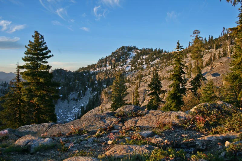
Rocky mountain landscape with scattered conifer trees in the foreground and midground, snow patches on the distant peak, and a blue sky with light clouds
English Peak rising above rocky terrain and scattered conifer forest in the Marble Mountain Wilderness

Marble Mountain Wilderness history and protected-area timeline

The early protection history of Marble Mountain Wilderness is rooted in the U.S. Forest Service's first attempts to preserve backcountry landscapes from logging, mining, and road-building. In April 1931, the area that would become today's wilderness was administratively set aside as the Marble Mountain Primitive Area, covering about 234,957 acres. It was one of four areas designated that year under the Forest Service's L-20 regulations, which represented the agency's earliest formal framework for keeping selected tracts of national forest in a primitive, undeveloped state.

That primitive designation governed management for more than three decades. In 1964, when the U.S. Congress passed the Wilderness Act and created the National Wilderness Preservation System, the Marble Mountain Primitive Area was reclassified as a federally designated wilderness area. At that point, its boundaries and protections were folded into the higher legal standard set by the new legislation, providing more durable protection against future development. The reclassification roughly corresponded to today's wilderness footprint of about 241,744 acres.

Human history in the Marbles goes back further than any administrative designation. Mining activity left its mark in the late nineteenth century. The wilderness's only established camp, located near Wooley Creek, is named after Anthony Milne, a miner who worked in the area around 1885. Other signs of historical use, including prospector routes and the numerous mining-era place names throughout the canyons, reflect a long period of small-scale resource extraction in the watershed, much of which was set aside when the primitive area was first established.

Marble Mountain Wilderness landscape and geographic character

Marble Mountain Wilderness is defined by a tight arrangement of high ridges and deeply cut canyons typical of the Klamath Mountains. The Salmon Mountains form a horseshoe-shaped high country at the core of the wilderness, with Marble Mountain itself forming a north-trending spur ridge off the Salmons. The Marbles' highest point is Boulder Peak at 8,299 feet, and from that high anchor the terrain radiates downward through rocky ridges, glacial-looking basins, and steep drainages to canyon floors near 400 feet. This produces more than 7,000 feet of vertical relief and a visually striking contrast between the open alpine country and the densely forested lower canyons.

The English Peak ridge is one of the most recognizable landscape features, running roughly twenty-two miles along the western edge of the wilderness. Below the high ridges, perennial mountain streams have carved long, narrow canyons with their own microclimates and vegetation zones, while the upper elevations hold classic high-country features: cirque-like basins, moraines, lake-filled valleys, and exposed rocky summits. In the high country, granite moraines above 6,000 feet cradle open meadows and chains of lakes, including the Sky High Lakes Basin and the Deep Lake area.

Geologically, the terrain is unusually varied, with at least five different rock types mapped across the wilderness. The mixture of pale limestone and dark metamorphic rock is what gives the Marbles their marbled look, and the wide assortment of rock types also drives the unusual soil diversity across the area. Below ground, the same geology has produced a network of caves with stalactites and other flowstone formations, including the deep Bigfoot Cave system. Add to this the Wild and Scenic river corridors of Wooley Creek and the North Fork of the Salmon River, and the result is a landscape where geology, water, and elevation combine to create a rugged, multi-layered terrain.

Marble Mountain Wilderness ecosystems, habitats, and plant life

The ecology of Marble Mountain Wilderness is unusually rich for an area of its size, a direct consequence of its geology, elevation range, and climate. More than 7,000 feet of vertical relief, soils derived from multiple rock types, and abundant rain and snowfall together create a biological diversity that is rare in the contiguous United States. Lower canyons hold dense mixed-conifer forests, montane zones transition through fir and pine stands, and the high country supports open subalpine habitats that look and behave very differently from anything in the canyons below.

A defining botanical feature of the wilderness is its collection of isolated, geographically rare conifer stands. Subalpine fir occurs here along granite moraines above 6,000 feet in open areas around lakes and meadows, including the Sky High Lakes Basin, Shelly Meadow along the Pacific Crest Trail, and the Deep Lake area. All of the subalpine fir groves in northwest California are more than fifty miles from the next closest subalpine fir stand, which sits in southern Oregon on Mount Ashland. The headwaters of the Salmon River also hold a relict stand of Pacific silver fir, the southernmost in the entire range of that species. These outlier populations give the wilderness exceptional botanical significance: it functions both as a refuge for cold-adapted conifers at the edge of their range and as a natural laboratory for understanding tree migration and climate response in the Klamath Mountains.

The wilderness is also notable for its serpentine soils, which support several rare and highly localized wildflowers. These include crested cinquefoil (Potentilla cristae), Siskiyou fireweed (Epilobium siskiyouense), and McDonald's rock cress (Arabis mcdonaldiana), a perennial that grows in conifer forests of California and Oregon. McDonald's rock cress is both state-listed since 1979 and federally listed since 1978 as endangered, making it one of the wildflowers most strongly linked to the conservation profile of the area. Beyond these rare elements, the broader vegetation mosaic also includes montane chaparral, montane meadows, riparian corridors along Wooley Creek and the Salmon River fork, and rock-dominated alpine communities at the highest elevations.

Marble Mountain Wilderness wildlife and species highlights

Marble Mountain Wilderness supports a full suite of northern California wildlife typical of large, roadless Klamath Mountains landscapes. Large mammals are a common sight for backcountry travelers. Black-tailed deer and American black bear are both regularly encountered, while less commonly seen species such as badger and wolverine also move through the area. The size and continuity of the wilderness, combined with relatively low human pressure, give these populations space to persist in patterns that would be difficult to maintain in more fragmented terrain.

Birdlife is one of the most distinctive elements of the Marbles. The great gray owl and the northern goshawk are notable forest breeders here. The wilderness also hosts the peregrine falcon and the bald eagle, both of which have been removed from the federal threatened and endangered species list in recent decades, with the peregrine falcon delisted in August 2007 and the bald eagle delisted in August 1999. These recoveries reflect the broader habitat quality of the area and its importance as nesting and foraging territory for high-profile raptor species.

Aquatic life in the Marbles is a defining feature of the wilderness's wildlife identity. Wooley Creek hosts a spring run of king salmon, as well as summer steelhead, while other streams hold resident rainbow trout. These fisheries, paired with the Wild and Scenic status of Wooley Creek and the North Fork of the Salmon River, make the watershed a meaningful contributor to the broader salmonid ecology of the Klamath system. For cavers and cave biologists, the wilderness's deep cave systems also host unique subterranean fauna in addition to their geological significance.

Marble Mountain Wilderness conservation status and protection priorities

Marble Mountain Wilderness's conservation significance rests on its long history of formal protection and the unusual concentration of ecological values it protects. The area has been shielded from large-scale development since 1931, when it was first designated as the Marble Mountain Primitive Area, one of the earliest primitive areas created under the Forest Service's L-20 regulations. In 1964, the Wilderness Act elevated that protection to the standard of the National Wilderness Preservation System, locking in the wilderness's status as a roadless, undeveloped landscape managed primarily for ecological and scenic values.

The wilderness is ecologically important for several reasons. Its more than 7,000 feet of vertical relief, combined with soil diversity driven by at least five rock types, produces an unusually broad range of ecosystems within a relatively compact footprint. The wilderness also anchors the southernmost outlier stands of subalpine fir in California and the southernmost Pacific silver fir stand in the species' entire range, making it a critical refuge for cold-adapted conifers at the edge of their climatic tolerance. The Wild and Scenic designations for Wooley Creek and the North Fork of the Salmon River add a further layer of protection, safeguarding both aquatic habitat and riparian communities.

The area's serpentine soils also contribute to its conservation significance by supporting several rare wildflowers, including the federally and state-listed endangered McDonald's rock cress (Arabis mcdonaldiana). Habitat for sensitive raptors, including the peregrine falcon and the bald eagle, both of which have been delisted after recovering in part on landscapes like this, underlines how the wilderness contributes to broader regional conservation outcomes. Cave conservation is a more specialized but real element of the area's conservation profile; cave mouths in the wilderness carry informational signs about white-nose syndrome, and the Forest Service works with the National Speleological Society to manage access to the most sensitive systems.

Marble Mountain Wilderness cultural meaning and human context

Marble Mountain Wilderness has a layered human history that predates its modern conservation designations. The late nineteenth century brought miners into the canyons and drainages of the Marbles, including Anthony Milne, a miner active in the area around 1885 after whom the in-wilderness camp near Wooley Creek is named. Prospector-era routes, diggings, and place names still trace early resource use across the watershed, even though most of that activity faded well before the area was formally protected.

The transition from a working landscape to a protected one began in 1931 when the Forest Service placed the Marble Mountain Primitive Area off-limits to large-scale development, framing it as one of the first primitive areas in the national forest system. Since then, the wilderness has shaped the identity of the surrounding region, supporting traditional uses such as backpacking, fishing, and cross-country skiing for communities in Siskiyou County and beyond. The wilderness's caving heritage also carries its own subculture, with the National Speleological Society and the Forest Service working together to manage access to deep, vertical cave systems that require experienced cavers. In this way, the Marbles remain a landscape where mining-era history, early conservation experimentation, and modern backcountry recreation all coexist within a single protected area.

Top sights and standout views in Marble Mountain Wilderness

Marble Mountain Wilderness's highlights cluster around its geological character, its rare plant communities, and its role as a backcountry recreation landscape. The marbled appearance of peaks where pale limestone meets dark metamorphic rock is the visual signature of the area, while Boulder Peak's 8,299-foot summit sets the high point and the Wild and Scenic river corridors of Wooley Creek and the North Fork of the Salmon River set the hydrological signature. Together they define an unusually varied wilderness footprint.

Ecologically, the wilderness harbors the southernmost stands of Pacific silver fir in the species' range and the most isolated stands of subalpine fir in California, alongside serpentine-soil wildflowers such as McDonald's rock cress and Siskiyou fireweed. Recreation highlights include the long stretch of Pacific Crest Trail through the wilderness, nearly ninety lakes, and one of the deepest cave systems in the contiguous United States, all set within a roadless landscape that has been protected for nearly a century.

Best time to visit Marble Mountain Wilderness

Seasonality in Marble Mountain Wilderness is shaped by elevation, snowfall, and the kinds of experiences visitors typically seek. The warmer months, generally from late spring through early fall, are the main season for backpacking and fishing. Snowmelt opens up higher trails and feeds the lakes and streams that make mid-summer a productive time for accessing alpine basins, wildflower viewing, and exploring the network of lakes across the Sky High Lakes Basin and the English Peak area. Lower canyon trails along Wooley Creek and the North Fork of the Salmon River are often most comfortable outside the heat extremes, when water levels are steady and the rivers are running clearly.

Winter transforms the wilderness into a cross-country skiing landscape. The 7,000-plus feet of vertical relief and the deep snowpack on the high ridges create opportunities for ski touring, particularly in the more open, lake-strewn terrain above the canyons. Those same winter conditions, however, also make many high-country trails inaccessible without significant snow travel experience, so the skiing experience tends to appeal to experienced backcountry users. Spring and fall shoulder seasons are quieter, when snow may still linger in the high country while the lower drainages become more accessible, and when wildlife viewing and solitude are typically at their peak.
Monthly climate preview

Long-term monthly temperature and precipitation patterns sampled at representative park elevations

Marble Mountain Wilderness Climate Normals and Annual Temperature Rhythm

Marble Mountain Wilderness exhibits a measured annual rhythm of changing temperatures and daily precipitation rates across twelve distinct recording periods. Reviewing the complete monthly climate profile reveals detailed long-term averages for high and low temperature thresholds.
Annual mean9 °C
1 °C20 °C
Jan
Feb
Mar
Apr
May10°
Jun14°
Jul20°
Aug20°
Sep17°
Oct10°
Nov
Dec
Warmest month
July

20.4 °C

Coolest month
December

1 °C

Wettest month
December

7.3 mm/day

Driest month
August

0.2 mm/day

Park location guide

Geography guide, regional context, and park location map for Marble Mountain Wilderness

Marble Mountain Wilderness park geography, regions, and map view in United States of America

Understand where Marble Mountain Wilderness sits in United States of America through a broader geographic reading of the surrounding landscape, nearby location context, and its mapped position within the national park landscape.

How Marble Mountain Wilderness fits into United States of America

The United States of America is a federal presidential republic and one of the world's largest countries by area and population. It consists of 50 states across a vast territory spanning multiple time zones, with its capital in Washington, D.C. and largest city in New York City. The nation has a diverse economy, influential political system, and significant cultural and military presence globally.

Wider geography shaping Marble Mountain Wilderness in United States of America

The United States occupies a vast territory in North America, bordered by Canada to the north and Mexico to the south. The 48 contiguous states stretch from the Atlantic to the Pacific Ocean, while Alaska occupies the northwestern region and Hawaii is an archipelago in the Pacific. The country encompasses diverse terrain including the Rocky Mountains, Appalachian Mountains, Great Plains, and extensive river systems.

Map view of Marble Mountain Wilderness

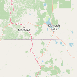
Use this park location map to pinpoint Marble Mountain Wilderness in United States of America, understand its exact geographic position, and read its mapped placement within the surrounding landscape more clearly.

Pigeon | © OpenStreetMap contributors

Location context for Marble Mountain Wilderness

CaliforniaSiskiyou County
Recorded earthquake history

Review the Historical Earthquake Catalogue for Marble Mountain Wilderness

Access a structured collection of recorded seismic events associated with the geography of Marble Mountain Wilderness. Use this data to examine historical activity patterns in the Klamath Mountains while exploring the landscape context through a mapped, event-based record maintained for geographical discovery.

Marble Mountain Wilderness Earthquake History

Catalogued events

74 events

Strongest magnitude

Magnitude 5.6

Most recent event

Sep 9, 2025

This history includes earthquakes recorded inside the park or within 50 km of its borders

Visualizing the rugged terrain, limestone peaks, and diverse protected habitats of northern California

Marble Mountain Wilderness Photos and Landscape Scenery

Explore detailed wilderness photography revealing the stark limestone ridges, deep water-carved canyons, and high alpine lakes of the Klamath Mountains. Visual records help researchers and travelers interpret the complex topography, rare conifer stands, and distinct protected-area environment.

Rocky mountain landscape with scattered conifer trees in the foreground and midground, snow patches on the distant peak, and a blue sky with light clouds

A calm lake reflecting snow-patched rocky ridges and a dense coniferous forest under a clear blue sky.

Park atlas

Compare surrounding Klamath Mountain protected landscapes and neighboring alpine habitats.

Exploring Other Protected Areas and National Parks Near Marble Mountain Wilderness

Browsing nearby national parks and connected wilderness zones reveals the broader ecological patterns shaping northern California. Comparing these adjacent conservation areas provides essential regional context for the rugged terrain surrounding Marble Mountain Wilderness.
Protected landscapeCalifornia
Mapped location lies within the park boundary#1 closest

West

Klamath National Forest; Protected Landscape Geography and Mapped Wilderness Boundaries

Diverse mountain terrain in Northern California

Klamath National Forest represents a significant protected area in Northern California, encompassing a vast, rugged landscape that bridges the Klamath Mountains and the Cascade Range. Its terrain is characterized by deeply incised river valleys, exposed rocky summits, and an intricate mosaic of coniferous forests. This geographic detail provides essential context on the forest's role as a major site for wilderness protection and ecological study in the Pacific Northwest.

Area
7,033 km²
Established
1905
Relief
Mountain
Climate
Temperate
Protected areaCalifornia
3.9 km away#2 closest

Northwest

Six Rivers National Forest: Exploring Protected River Valleys and Mountain Terrain in California

A regional protected area spanning California river systems

Six Rivers National Forest defines much of the rugged landscape in northwestern California. Named for the six major river drainages within its borders, the area features a unique combination of coastal forests, deep river canyons, and high-country ridges that offer significant insight into the region's broader geographic and ecological character.

Area
3,875.2 km²
Established
1947
Relief
Mountain
Climate
Mediterranean
Protected landscapeCalifornia
19 km away#3 closest

South

Shasta, Trinity National Forest: Mapping the Protected Landscapes of Northern California

Volcanic peaks, expansive reservoirs, and rugged mountain wilderness

Spanning over two million acres, Shasta, Trinity National Forest represents a major protected landscape in Northern California. The geography includes the iconic Mount Shasta volcano and the complex shoreline of Shasta Lake, while hosting expansive wilderness areas and diverse terrain ranging from oak-forested foothills to alpine meadows.

Area
8,942.87 km²
Established
1954
Relief
Mountain
Climate
Temperate
Protected landscapeCalifornia
24 km away#4 closest

Northwest

Smith River National Recreation Area: Mapping the Klamath Mountain Protected Landscape

Watershed geography and rugged mountain terrain in northwestern California

Located in the heart of the Klamath Mountains, Smith River National Recreation Area represents a critical protected watershed in northern California. The area is defined by its deep, forested canyons and the clean, wild waters of the Smith River, which serve as a primary link between coastal redwood ecosystems and mountainous inland terrain. Users can study the park boundaries and regional landscape characteristics that sustain this remote environment.

Area
1,235 km²
Established
1990
Relief
Mountain
Climate
Mediterranean
Wildlife reserveCalifornia
25 km away#5 closest

North

Red Buttes Wilderness: Mapping the Protected Mountain Geography of the Siskiyou Range

A rugged wilderness reserve straddling California and Oregon

Red Buttes Wilderness preserves a complex mountainous terrain shaped by ancient metamorphic rocks and glacial history. The area features high ridgelines, alpine lakes, and specialized botanical habitats, providing a vital window into the ecological and geological diversity of the broader Klamath and Siskiyou mountain landscapes.

Area
80.7 km²
Established
1984
IUCN
Ib
Relief
Mountain
Protected landscapeOregon
25 km away#6 closest

Northwest

Rogue River, Siskiyou National Forest: Mapped Geography and Protected Area Overview

Tracing volcanic peaks and river-carved mountain terrain in Oregon

Spanning nearly 7,300 square kilometers, the Rogue River, Siskiyou National Forest acts as a crucial ecological anchor in the Pacific Northwest. This overview details its unique mountain geography, the extensive wilderness tracts within its boundaries, and the river systems that define its mountainous character.

Area
6,973.46 km²
Established
2004
Visitors
915K annual
Relief
Mountain
National parkCalifornia
43 km away#7 closest

West

Redwood National and State Parks: Protected Landscape Geography and Mapped Boundaries

Explore California's protected area atlas.

Gain a structured understanding of Redwood National and State Parks as a protected national park within the geographic context of California. This dedicated page focuses on its mapped boundaries and protected landscape identity, offering critical atlas-level insights for regional geography exploration and conservation land context. Discover how this protected area fits into the larger mapped terrain.

Area
562.88 km²
Established
1968
IUCN
V
Visitors
458.4K annual
Wildlife reserveCalifornia
58 km away#8 closest

East

Mount Shasta Wilderness: A Geographic Profile of California Volcanic and Alpine Landscapes

Mapping protected volcanic peaks and glacial ecosystems

Deeply explore the protected geography of Mount Shasta Wilderness, a 38,200-acre reserve in Northern California. This record details the park's stratovolcano foundations, glacial terrain, and forested corridors, offering a clear view of the complex landforms and boundary systems that define this significant high-elevation protected area.

Area
155 km²
Established
1984
IUCN
Ib
Relief
Mountain

Common questions about visiting, size, designation, and location context for Marble Mountain Wilderness

Marble Mountain Wilderness FAQs for park facts, access, geography, and protected area context

Find quick answers about Marble Mountain Wilderness, including protected-area facts, park geography, trail and visitor context, and how the park fits into its surrounding country and regional landscape.
MoriAtlas Explorer

Continue Your Protected Areas Search Across the Global Atlas

Deepen your exploration by continuing the structured search for national parks and protected areas worldwide. Utilize the comprehensive filtering capabilities to compare different conservation landscapes and refine your understanding of global park geography. Discover more about the distribution and characteristics of protected natural areas.

Global natural geography