

Mori Atlas logo
Natural monumentMeandry Ploučnice u Mimoně

Examining the complex meander lakes and floodplain terrain of this protected Bohemian river system

Meandry Ploučnice u Mimoně Natural Monument: A Study in Unregulated River Morphology and Wetland Geography

(Přírodní památka Meandry Ploučnice u Mimoně)

The Meandry Ploučnice u Mimoně natural monument stands as a rare example of a free-flowing, unregulated river system within the Liberec Region. This protected area features a series of deep meander lakes and saturated wetland habitats that support critical aquatic species and biodiversity. By maintaining natural hydrological dynamics, the site offers a glimpse into the characteristic river morphology of the Bohemian lowlands, serving as an essential ecological refuge within its broader regional landscape.

river meanderswetlandsfree-flowing riverfloodplainnatural monumentIUCN Category IV
A stylized illustration of a winding river surrounded by green trees and steep rocky cliffs under a soft sunset sky.

Meandry Ploučnice u Mimoně

Natural monument

Park overview

Structured park overview, official facts, and landscape profile for Meandry Ploučnice u Mimoně

Meandry Ploučnice u Mimoně park facts, protected area profile, and essential visitor context

Review the core facts for Meandry Ploučnice u Mimoně, including designation, size, terrain, visitor scale, habitats, and operating context in one park-focused overview.

About Meandry Ploučnice u Mimoně

Meandry Ploučnice u Mimoně is a small, ecologically focused protected area in the Czech Republic dedicated to preserving a natural stretch of the Ploučnice River and its associated wetlands. While not a national park, it carries the protected status of přírodní památka, a designation reserved for sites of particular geological, hydrological, or biological importance. The protected area anchors itself on a segment of the Ploučnice that has retained its meandering, unregulated character, a rarity in central European lowlands where most rivers have been straightened, deepened, or otherwise modified.

The site lies in the Liberecký kraj, in the district of Česká Lípa, within the broader Ralsko municipality. It is positioned in the low corridor between Boreček to the south and Mimoň to the north, framed by two secondary roads (II/268 to the east and II/270 to the west) and bordered to the south by the former Hradčany airfield site. The terrain here is low-lying and gently undulating, with the river and its floodplain forming the dominant topographic and ecological feature. A defunct industrial settling pond (odkaliště) lay just to the north until 2019, and a photovoltaic power plant occupies part of the surrounding landscape, but the protected area itself remains focused on natural hydrological and biological values.

Ecologically, the monument is significant because it combines three elements that rarely occur together in heavily settled landscapes: a free-flowing meandering river, a network of meander lakes that act as refuge habitats, and adjoining wetland vegetation shaped by natural flooding. Together these features support rare species and ecological processes that depend on intact river dynamics. Because the area is also part of the wider European Important Site Horní Ploučnice, it functions both as a standalone natural monument and as a core element of a larger Natura 2000 conservation context for the upper Ploučnice catchment.

Quick facts and research context for Meandry Ploučnice u Mimoně

Meandry Ploučnice u Mimoně is a přírodní památka, a category of small-scale natural monument used in the Czech system of protected areas. It lies in the Liberecký kraj in northern Bohemia, administered by the Krajský úřad Libereckého kraje. The protected area covers about 49 hectares and sits at elevations between roughly 269 and 276 meters above sea level. Geographically it lies in a lowland wedge between the settlements of Boreček and Mimoň, framed by secondary roads and bordered to the south by the former Hradčany airfield. The site is classified under IUCN Category IV and forms part of the broader European Important Site Horní Ploučnice.

Protection and recognition

Terrestrial conservation frameworks and verified administrative status records

Meandry Ploučnice u Mimoně Protection Status and Official Designated Area Records

Terrestrial protection status records outline the administrative management scope established for Meandry Ploučnice u Mimoně. Verified designation entries compile documented conservation frameworks without international recognition sources.

Protection details

Protection scope
Terrestrial
Transboundary protection
No
Park context

Deeper park guide and search-rich context for Meandry Ploučnice u Mimoně

Meandry Ploučnice u Mimoně history, landscape, wildlife, and travel context

Explore Meandry Ploučnice u Mimoně through its history, landscape character, ecosystems, wildlife, conservation priorities, cultural context, and seasonal travel timing in a structured park guide built for atlas discovery and search intent.

Why Meandry Ploučnice u Mimoně stands out

The natural monument is best known for its free-flowing, unregulated meanders of the Ploučnice River and the unusually well-developed meander lakes they create. These calm, deep loops form the hydrological and ecological backbone of the protected area and provide habitat for species that depend on undisturbed river morphology. It is also recognized for its rare assemblage of aquatic and wetland fauna, including a strong population of the club-tailed dragonfly, breeding colonies of two specialized wetland butterflies, a territorial population of Eurasian otter, and occasional Atlantic salmon migrating through the catchment. Together these features make the site a compact but characteristic example of Bohemian lowland river and floodplain ecology.
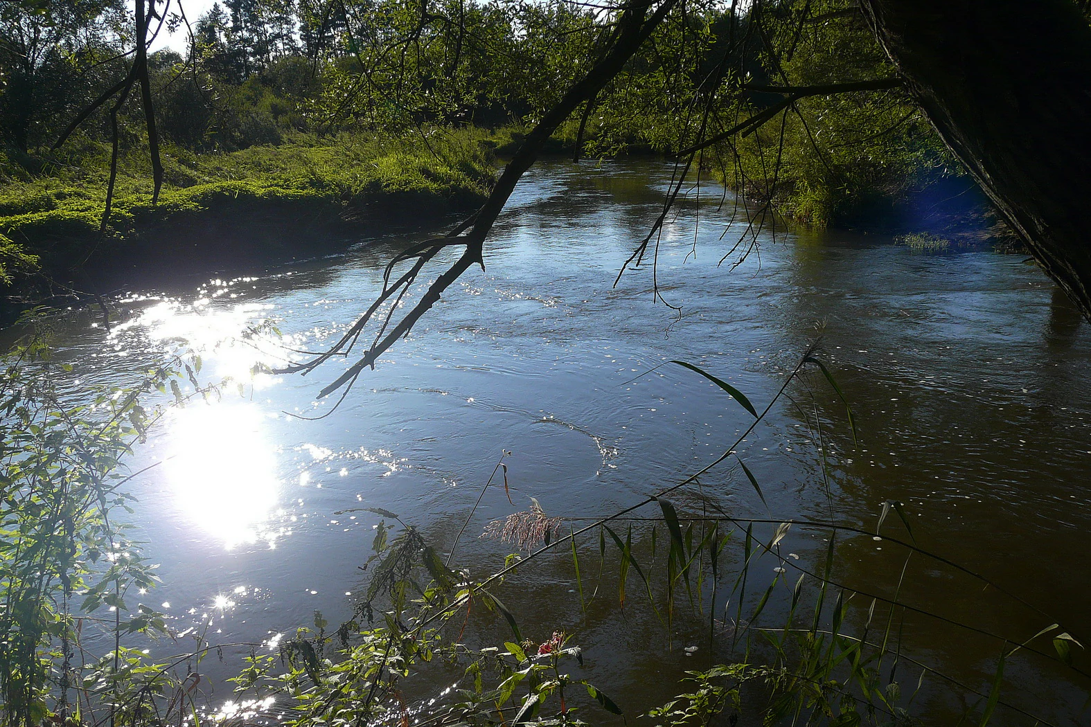
A sunny, eye-level view of the Ploučnice River flowing between green, forested banks, with sunlight reflecting brightly on the water surface.
A view of the Ploučnice River meandering through the landscape of the natural monument.

Meandry Ploučnice u Mimoně history and protected-area timeline

The protected landscape of Meandry Ploučnice u Mimoně is largely a story of preservation rather than long historical management. The site received its formal protection on 15 July 2014, when it was declared a přírodní památka (natural monument) by the Krajský úřad Libereckého kraje, the regional authority of the Liberecký kraj. Its designation was driven by the recognition that this reach of the Ploučnice had retained an unregulated, naturally meandering course and supported rare wetland-dependent species.

Even before formal protection, the area was already recognized through its inclusion in the European Important Site known as Horní Ploučnice, tying local conservation efforts to broader Natura 2000 priorities in the upper Ploučnice basin. Surrounding land uses shifted during the early twenty-first century: an industrial settling pond (odkaliště) immediately north of the protected area was shut down in 2019, and a photovoltaic power plant, the Fotovoltaická elektrárna Mimoň Ra 3, was developed on adjacent land. These changes reduced some historical pressures on the site and helped frame its current role as an ecological refuge amid a working landscape of roads, former industrial sites, and renewable energy infrastructure.

Meandry Ploučnice u Mimoně landscape and geographic character

The landscape of Meandry Ploučnice u Mimoně is defined by the behavior of an unregulated river rather than by dramatic topography. Elevations across the protected area sit only between roughly 269 and 276 meters above sea level, placing the site firmly in the Bohemian lowland range. Within this otherwise gently undulating corridor, the Ploučnice traces a series of pronounced bends, slicing through floodplain sediments and carving out the mature meanders that give the natural monument its name.

The most distinctive landforms within the site are the meander lakes. These are not lakes in the conventional sense but rather the calm, deep, partly isolated loops that develop along a strongly meandering river. Each bend creates a sheltered pocket of water that is visibly quieter than the main current, often appearing as a broad, still backwater separated from the active channel by a narrow neck of sediment or vegetation. The protected area also includes the final segment of the Ploužnický potok and its confluence with the Ploučnice, extending the network of waterbodies and bankside habitats.

Beyond the river itself, the immediate surroundings include a mix of floodplain vegetation, former industrial features such as the now-defunct settling ponds, transport corridors along the secondary roads II/268 and II/270, and the open grounds of the former Hradčany airfield to the south. The result is a small but visually distinct mosaic where a working agricultural and infrastructural landscape meets a preserved, naturally shifting river system.

Meandry Ploučnice u Mimoně ecosystems, habitats, and plant life

The natural character of the site is fundamentally wetland- and river-driven. The Ploučnice in this reach still behaves as a free-flowing, meandering river, meaning that flooding, sediment movement, and channel migration continue to shape the habitat. These disturbances naturally reorganize the floodplain, so vegetation patterns here are dynamic rather than static, and the exact arrangement of aquatic plant beds changes with the shifting morphology of the river bed.

Within the channel, submerged aquatic plants form the core of the in-stream flora. Beds of water crowfoot, especially Ranunculus fluitans (referenced in the Czech source as lakušník), and several starwort species, typically Callitriche hamulata, are characteristic of these clear, cool, moving waters. Their stands extend into the slower meander lakes, where reduced current allows different plant communities to develop. The floodplain vegetation responds to flooding events, with the composition and extent of individual patches fluctuating according to recent water levels and channel shape.

Around the channel, the mosaic of saturated bankside ground, flooded margins, and riparian vegetation creates the wetland conditions that anchor the site's ecological value. Because the reach has not been regulated or channelled, these habitats remain hydrologically connected to the river, supporting both aquatic and semi-aquatic species and maintaining the natural function of the floodplain as a buffer, filter, and habitat network.

Meandry Ploučnice u Mimoně wildlife and species highlights

The wildlife profile of Meandry Ploučnice u Mimoně reflects its identity as a protected river and wetland complex. Among invertebrates, the site is notable for its strong population of the club-tailed dragonfly (Ophiogomphus cecilia), an indicator species for clean, well-oxygenated lowland rivers. In addition, two specialized wetland butterflies maintain small but established colonies here: the scarce large blue (Phengaris teleius) and Lycaena dispar, both of which depend on intact, traditionally managed wet meadows and floodplain vegetation associated with the river corridor.

The otter is one of the defining mammal presences in the protected area. The Eurasian otter (Lutra lutra) maintains a territorial presence throughout the site, using the river, the meander lakes, and the tributary streams as core hunting and travel habitat. This makes the area functionally important for a species that requires undisturbed shorelines, dense bank vegetation, and clean water.

Fish also benefit from the site's unregulated character. The lowland stretch of the Ploučnice retains characteristics that allow occasional migration of Atlantic salmon (Salmo salar), with young individuals recorded moving downstream toward the sea and adults temporarily using the reach as they travel toward spawning grounds. The presence of salmon highlights the connectivity between this small protected segment and the wider catchment, including upper Ploučnice tributaries used as spawning habitat.

Meandry Ploučnice u Mimoně conservation status and protection priorities

Meandry Ploučnice u Mimoně carries formal protection as a přírodní památka (natural monument) under the Czech system of protected areas, and at international level it falls within IUCN Category IV, a category aimed at the conservation of particular species or habitats through active management. Its selection reflects both the specific hydrological value of the river reach and the biological importance of the species it supports.

In addition to its national designation, the site is incorporated into the European Important Site Horní Ploučnice (evropsky významná lokalita), placing it within the Natura 2000 network that coordinates habitat protection across European Union member states. This dual status means conservation objectives at the site align with broader efforts to maintain and restore natural processes and species populations across the upper Ploučnice catchment.

The conservation focus is on preserving the unregulated, meandering character of the Ploučnice and the integrity of its floodplain wetlands, recognizing that rare species here depend on continued natural river dynamics rather than on artificial habitat management. Protecting these processes is seen as the most effective way to sustain the dragonfly, butterfly, otter, and fish populations that give the small site its outsized ecological meaning.

Top sights and standout views in Meandry Ploučnice u Mimoně

Meandry Ploučnice u Mimoně stands out for being one of the few remaining free-flowing, naturally meandering stretches of the Ploučnice River. Its defining signature is the chain of meander lakes, calm, deep loops that visually and ecologically anchor the protected area and create the conditions for specialized wetland life.

The site also carries notable conservation weight through its integration into the Natura 2000 Important Site Horní Ploučnice, and through the presence of species that act as ecological indicators: the club-tailed dragonfly for river health, the scarce large blue butterfly for floodplain meadow conditions, the otter for intact shoreline habitat, and the occasional Atlantic salmon for catchment-level connectivity. Together these qualities give the natural monument a focused but recognizable ecological identity well beyond its modest 49 hectares.

Best time to visit Meandry Ploučnice u Mimoně

The natural monument is at its most expressive during the warmer months, when wetland vegetation is in full growth and the aquatic plant beds of water crowfoot and starwort are visible in the clearer river sections. Late spring and summer are also when dragonflies are most active around the meander lakes, and when wetland butterflies are easiest to observe along the floodplain margins, making this the most rewarding period for wildlife-oriented attention to the site.

Autumn brings a quieter, more reflective atmosphere as floodplain vegetation dries back and water levels shift, occasionally exposing different parts of the channel and reinforcing the dynamic, ever-changing character of the river. Because the site is a working natural area rather than a developed visitor attraction, any visit should treat seasonality as a way of choosing between maximum biological activity in summer and a calmer, more contemplative landscape experience in autumn or early spring.


Monthly climate preview

Long-term representative temperature and monthly precipitation averages

Meandry Ploučnice u Mimoně Climate Normals and Annual Weather by Month

Representative point measurements reveal the long-term annual temperature and precipitation rhythm across Meandry Ploučnice u Mimoně. Examining the full monthly data profile provides deeper insight into historical climate patterns at this specific coordinate.
Annual mean8 °C
-3 °C19 °C
Jan-3°
Feb-2°
Mar
Apr
May13°
Jun17°
Jul19°
Aug18°
Sep13°
Oct
Nov
Dec-2°
Warmest month
July

18.7 °C

Coolest month
January

-3.1 °C

Wettest month
July

2.9 mm/day

Driest month
April

1.3 mm/day

Park location guide

Geography guide, regional context, and park location map for Meandry Ploučnice u Mimoně

Meandry Ploučnice u Mimoně park geography, regions, and map view in Czechia

Understand where Meandry Ploučnice u Mimoně sits in Czechia through a broader geographic reading of the surrounding landscape, nearby location context, and its mapped position within the national park landscape.

How Meandry Ploučnice u Mimoně fits into Czechia

Czech Republic is a landlocked Central European country with a population of approximately 10.9 million people. The nation was established as an independent state on January 1, 1993, following the dissolution of Czechoslovakia. Its capital and largest city is Prague, with other major urban centers including Brno, Ostrava, Plzeň, and Liberec.

Wider geography shaping Meandry Ploučnice u Mimoně in Czechia

The Czech Republic is a landlocked country in Central Europe. It is bordered by Germany to the west, Austria to the south, Poland to the northeast, and Slovakia to the southeast. The landscape is predominantly hilly, with the territory covering 78,871 square kilometers.

Map view of Meandry Ploučnice u Mimoně

Use this park location map to pinpoint Meandry Ploučnice u Mimoně in Czechia, understand its exact geographic position, and read its mapped placement within the surrounding landscape more clearly.

Pigeon | © OpenStreetMap contributors

Location context for Meandry Ploučnice u Mimoně

Liberec Region

Visualizing the unregulated river meanders, wetlands, and floodplain habitats of the protected area

Meandry Ploučnice u Mimoně Photos and Landscape Scenery Exploration

Examinations of real park photography reveal the distinct morphology of the free-flowing Ploučnice River and its adjoining meander lakes. Visual records provide deep insight into the protected terrain, bankside vegetation, and specialized aquatic environments shaping the Bohemian lowlands.

A sunny, eye-level view of the Ploučnice River flowing between green, forested banks, with sunlight reflecting brightly on the water surface.

Park atlas

Compare surrounding lowland river corridors and connected conservation landscapes

Parks Near Meandry Ploučnice u Mimoně and Regional Protected Areas

Browse other protected areas and natural monuments located near Meandry Ploučnice u Mimoně to examine broader regional river morphology and wetland habitats. Comparing adjacent conservation landscapes provides valuable geographic context for understanding Bohemian lowland ecosystems.
Natural monumentLiberec Region
About 4.6 km away#1 closest

Northeast

Vranovské skály Natural Monument: Protected Sandstone Towers in the Liberec Region

Geographic analysis of sandstone pillars and protected upland forest terrain.

Vranovské skály stands as a significant natural monument in the Liberec Region, preserving a cluster of bright sandstone towers that contrast with the dark forests of the Ralská pahorkatina. This protected area includes several named formations and botanical niches shaped by historical land use. Its geography offers a clear example of sandstone geomorphology and its role in maintaining regional biodiversity within the broader context of northern Bohemia.

Area
0.129 km²
Established
1991
IUCN
IV
Relief
Upland
Natural monumentCentral Bohemian Region
About 13 km away#2 closest

Southeast

Velký Radechov Natural Monument: Geography and Protected Habitat Mapping

Neovolcanic upland terrain within the Central Bohemian Region

Explore the mapped boundaries and natural features of Velký Radechov. This protected site in the Central Bohemian Region serves as an ecological mosaic, showcasing how neovolcanic hill slopes and formerly managed habitats provide refuge for a wide range of flora and fauna in the Czech landscape.

Area
0.22 km²
Established
1999
IUCN
IV
Relief
Upland
Natural monumentStředočeský kraj
About 17 km away#3 closest

Southeast

Valcha Natural Monument: Mapping Protected Wetland Ecosystems in Středočeský Kraj

A rare mosaic of forest ponds and mire habitats

Situated in the Středočeský kraj region, Valcha Natural Monument protects a distinctive silting pond and marshland ecosystem. This site demonstrates the ecological significance of small, hydrologically active ravine landscapes nestled within the broader Jizerská tabule plateau terrain, providing critical refuge for rare wetland species.

Area
0.024 km²
Established
2013
IUCN
III
Relief
Lowland
A horizontal watercolor painting of a serene pond surrounded by marshy vegetation and small clusters of trees under a soft, light-filled sky.
Nature reserveLiberec Region
About 18 km away#4 closest

Northwest

Manušické rybníky Nature Reserve and Protected Wetland Landscape in Liberec Region

Historic fishpond mosaic and critical amphibian refuge

Manušické rybníky is a well-documented nature monument in the Czech Republic featuring a chain of seven fishponds established in 1575. The site preserves vital lowland peatland fragments and pine-oak woodlands, serving as a significant ecological node for wetland flora and amphibians within the broader landscape of the Liberec Region.

Area
0.143 km²
Established
2012
IUCN
IV
Relief
Upland
A soft watercolor painting of a hilly landscape featuring pine trees and low-lying vegetation in shades of green, yellow, and red, with a pale background.
Natural monumentLiberec Region
About 19 km away#5 closest

West

Martinské stěny Natural Monument: Sandstone Cliff Geography and Protected Landscapes

Geomorphology and sandstone terrain in the Liberec Region

Martinské stěny features a prominent quartz sandstone cliff wall shaped by geological forces in the Bohemian Cretaceous Basin. This natural monument serves as a key protected area for heath and lichen communities, representing the unique cliff-side geography found throughout the Liberec Region in the northern Czech Republic.

Area
0.032 km²
Established
2002
IUCN
III
Relief
Upland
Natural monumentCentral Bohemian Region
About 20 km away#6 closest

Southeast

Vrch Káčov Natural Monument: Mapped Geological Features in Central Bohemia

Volcanic rock formations and regional terrain context

Vrch Káčov is a designated natural monument preserving a unique volcanic hill and rock suk in the Central Bohemian Region. Its landscape is defined by contact metamorphism and porcelanite formations, offering a concentrated look at the geological evolution of the Jičínská pahorkatina hill country. The site provides a valuable reference for analyzing protected Bohemian terrain and its surrounding geographic characteristics.

Area
0.019 km²
Established
1953
IUCN
III
Relief
Upland
A soft watercolor illustration depicting a riverbank with light green trees and a prominent rocky outcrop or cliff face near the water.
Natural monumentCentral Bohemian Region
About 20 km away#7 closest

Southeast

Skalní sruby Jizery Natural Monument: Sandstone Landforms and River Geography

Protected riparian sandstone terrain in the Central Bohemian Region

This natural monument protects a rare geological formation along the Jizera River, where lateral erosion has created an extensive sandstone rock shelter. The site showcases advanced pseudokarst weathering and supports a dense concentration of botanical and avian diversity within its two-hectare boundary in the Central Bohemian Region.

Area
0.02 km²
Established
1979
IUCN
III
Relief
Upland
A watercolor illustration of rolling hills and a green landscape with a soft, abstract style.
Nature reserveLiberec Region
About 22 km away#8 closest

West

Ronov Nature Reserve: Protected Volcanic Geography and Scree Forest Ecosystems in Liberec Region

Volcanic landmark with basalt talus slopes and historic ruins

Ronov rises as a distinctively shaped basalt cone from the rolling terrain of the northern Czech Republic. This nature reserve offers significant insight into the geological and botanical character of the Ralská pahorkatina, featuring extensive stone seas and rare plant habitats situated around ancient castle remains.

Area
0.09 km²
Established
1995
IUCN
IV
Relief
Mountain

Common questions about visiting, size, designation, and location context for Meandry Ploučnice u Mimoně

Meandry Ploučnice u Mimoně FAQs for park facts, access, geography, and protected area context

Find quick answers about Meandry Ploučnice u Mimoně, including protected-area facts, park geography, trail and visitor context, and how the park fits into its surrounding country and regional landscape.
MoriAtlas Explorer

Continue Your Protected Areas Search Across the Global Atlas

Deepen your exploration by continuing the structured search for national parks and protected areas worldwide. Utilize the comprehensive filtering capabilities to compare different conservation landscapes and refine your understanding of global park geography. Discover more about the distribution and characteristics of protected natural areas.

Global natural geography