

Mori Atlas logo
Natural monumentMedlovický lom

A rare porcelanite exposure within the rolling terrain of the Moravian foothills and Vážanská vrchovina

Medlovický lom Natural Monument: Geological Profile and Protected Landscape Context in Zlínský Kraj

Medlovický lom represents a distinct protected natural monument in the Zlínský kraj region, preserving a fifty-meter-long quarry wall that reveals the geological history of the area. This site serves as a vital record of porcelanite formation caused by ancient lignite combustion, while the small pool at the quarry base provides a specialized habitat for local amphibian populations. Its position within the Moravian landscape links the Chřiby hills to the broader Kyjovská pahorkatina, grounding this geological feature within a traditional rural environment.

natural monumentgeological siteporcelaniteformer quarryflysch landscapeMoravian foothills

Medlovický lom

Natural monument

Park overview

Structured park overview, official facts, and landscape profile for Medlovický lom

Medlovický lom park facts, protected area profile, and essential visitor context

Review the core facts for Medlovický lom, including designation, size, terrain, visitor scale, habitats, and operating context in one park-focused overview.

About Medlovický lom

Medlovický lom is a small but scientifically distinctive protected natural monument in southeastern Moravia. Although it covers barely more than a hectare and is often described as a single old quarry face, the site has been protected since 1997 because of the unusual geological section visible in its walls. The exposure records the transformation of Paleogene clays into porcelanite through natural combustion of an underlying lignite seam.

The protected area lies on the Vážanská vrchovina, a geomorphological subunit of the Kyjovská pahorkatina in the Středomoravské Karpaty, close to the margin of the Chřiby hills. Its position at the transition between these landscape units adds to its character as a landscape marker, even though the immediate surroundings are dominated by rolling farmland and the traditional rural scenery of the Uherské Hradiště district.

In practical terms, the monument consists of a roughly fifty-meter-long quarry wall, up to five meters high, and a small pool that has formed at the base of the worked-out pit. Together these features combine to illustrate the geological process that created the porcelanite, the stratigraphic relationships with overlying and underlying sediments, and the modest ecological role that a former extraction site can play once extraction ends.

Because porcelanite is a comparatively rare lithology and the Medlovice outcrop shows it unusually completely, the site has been recognized as a natural monument at the district level. It is also a reminder of how traditional local uses of stone, from road building to decorative walking paths, intersected with what is now seen as a heritage-worthy geological feature.

Quick facts and research context for Medlovický lom

Medlovický lom is a registered natural monument (přírodní památka) located in the Zlín Region of the Czech Republic, within the Uherské Hradiště district and just outside the village of Medlovice. It covers about 1.1 hectare of land at roughly 330 meters above sea level, sitting on the edge of the Chřiby hills within the broader Kyjovská pahorkatina highland.

The site was declared a protected area on 7 September 1997 by the former District Office of Uherské Hradiště, primarily to preserve a complete profile of porcelanite exposed in the old quarry wall. The stone itself is fired clay created when a Paleogene lignite seam burned naturally during the Pannonian period, an unusual geological process that gives the rock its deep red, brown, and grey colors.

Park context

Deeper park guide and search-rich context for Medlovický lom

Medlovický lom history, landscape, wildlife, and travel context

Explore Medlovický lom through its history, landscape character, ecosystems, wildlife, conservation priorities, cultural context, and seasonal travel timing in a structured park guide built for atlas discovery and search intent.

Why Medlovický lom stands out

Medlovický lom is best known among geologists and natural heritage enthusiasts for its exceptionally complete exposure of porcelanite, a brick-red fired clay that formed when an ancient lignite seam spontaneously burned. The roughly fifty-meter-long quarry wall is one of the most accessible and visually striking natural profiles of this rare material in the Czech Republic. Visitors and specialists also value the site for its small quarry pool, which has become an amphibian habitat, adding a modest ecological dimension to what is otherwise primarily a geological monument.
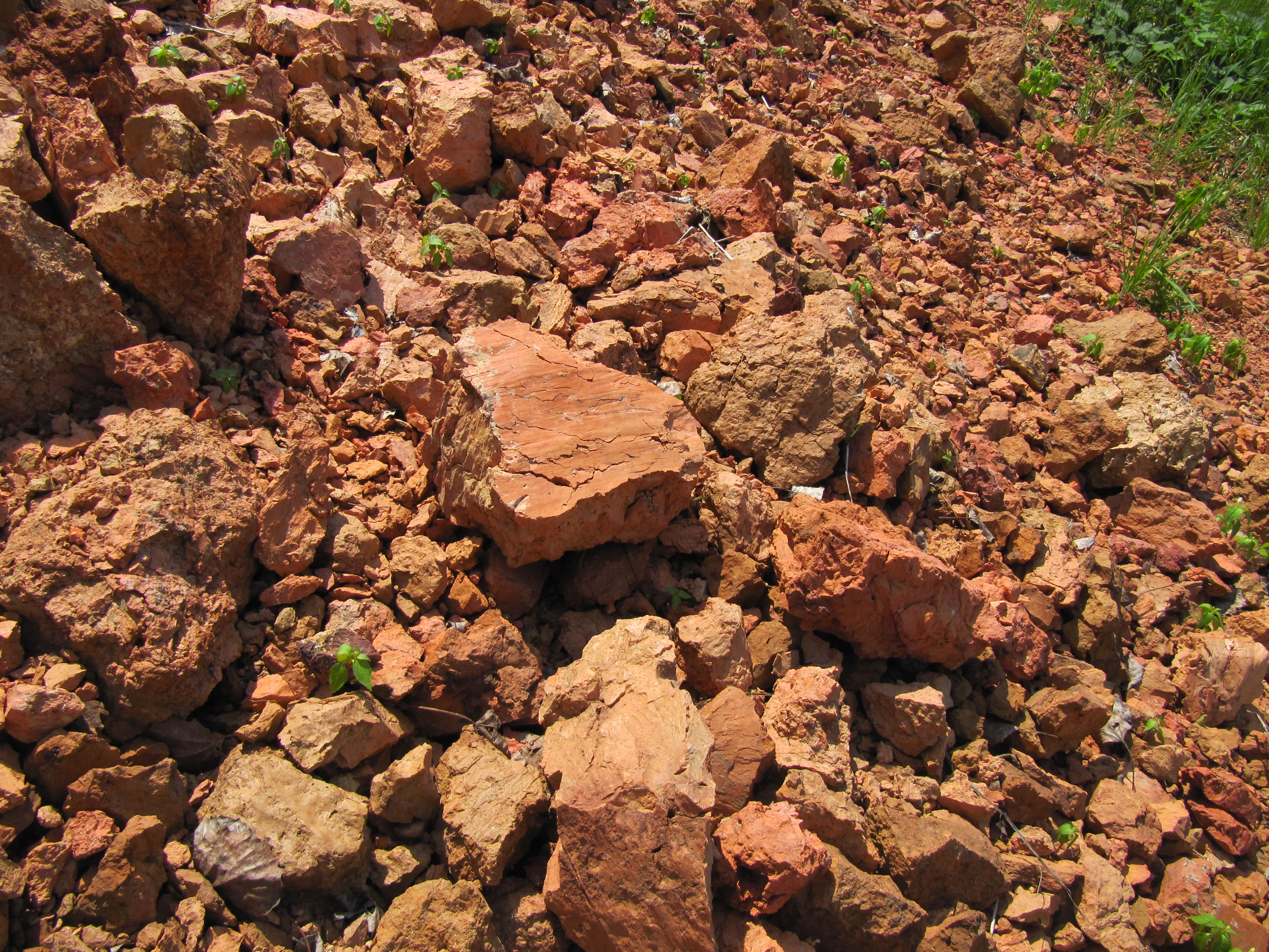
Medlovicky quarry view
A view of the Medlovicky quarry.

Medlovický lom history and protected-area timeline

The first documented reference to the porcelanite at Medlovice dates from 1884, when small-scale quarrying of the red-colored stone was already taking place. Locals referred to the material as červenka or červenice, and used it locally for building and surfacing.

A new quarry at the present location of the protected area was opened only in the twentieth century, in the years before the Second World War. From the 1950s through the 1970s, the agricultural cooperative from Boršice near Buchlovice extracted the stone, grinding and using it to reinforce local roads and as a building aggregate. Porcelanite from Medlovice was also used as a decorative surface in pathways within the chateau park at Buchlovice.

After 1997, when the site was declared a natural monument, industrial extraction was halted. Despite a barrier being placed at the entrance to the quarry in 1998, repeated attempts by local residents and landowners to resume illegal extraction have remained a continual pressure on the protection of the area.

Medlovický lom landscape and geographic character

The landscape around Medlovický lom is shaped by the gentle hills of the eastern margin of the Středomoravské Karpaty. The site sits on the Vážanská vrchovina, a subunit of the broader Kyjovská pahorkatina, with the Žádovická pahorkatina forming the immediate geomorphological context.

To the south and east rise the wooded ridges of the Chřiby, while the surroundings of the quarry are more open and agricultural, dominated by fields, small villages, and traditional Moravian rural land use. The quarry itself is a small scar cut into this otherwise smooth terrain, where the previously extracted material has left an artificial cliff face.

The quarry wall is roughly fifty meters long and rises up to five meters, exposing a continuous cross-section through the porcelanite body and its contact zones with overlying and underlying rocks. At its base, a shallow pool collects water, adding a minor wetland element to the otherwise dry, stony setting of the abandoned pit.

Medlovický lom ecosystems, habitats, and plant life

Ecologically, Medlovický lom is a very small but locally meaningful site within a largely agricultural landscape. The habitat value of the protected area is concentrated in two contrasting microenvironments: the bare rock and weathered stone of the quarry face, and a shallow seasonal pool at the base of the pit.

The quarry face itself supports limited vegetation because the porcelanite is hard and breaks into sharp-edged fragments, but its exposed surfaces are part of the geological protection. The shallow pool at the bottom of the quarry provides breeding habitat for several amphibian species, making the old extraction site a small refuge in an otherwise intensively farmed area.

The wider surroundings of the quarry are typical of the eastern Moravian foothills, with mixed agricultural land, small woodlands, and the edges of the Chřiby forest complex nearby. This combination of open farmland and forest margin gives the broader locality a transitional character between lowland and hill forest ecosystems.

Medlovický lom wildlife and species highlights

Wildlife is not the primary focus of Medlovický lom, which is protected chiefly for its geological value. The most consistent faunal feature of the site is the amphibian community that uses the shallow pool at the base of the quarry.

Amphibians are explicitly mentioned in the protection rationale because the pool offers an unusual, largely predator-free breeding habitat in the middle of an agricultural landscape. Beyond this small pool, the surrounding countryside supports the typical fauna of the Moravian foothills, but the protected area itself is too small to host richer woodland or meadow wildlife communities.

Medlovický lom conservation status and protection priorities

Medlovický lom has been protected since 7 September 1997, when it was declared a přírodní památka, a natural monument, by the former District Office of Uherské Hradiště under the Czech nature conservation system. Its IUCN-compatible category places it among small sites recognized primarily for outstanding geological features.

The conservation rationale rests on the quarry wall as a complete natural profile of porcelanite, including the contact zones with both overlying and underlying strata, which makes the site scientifically valuable for understanding the unusual process of natural clay firing by burning lignite. The small pool at the base of the quarry adds an amphibian component to the protection objectives.

Protection is not without challenges: although entry to the quarry has been physically restricted since 1998, recurring attempts at illegal extraction by local residents and landowners continue to threaten the integrity of the geological profile. This makes ongoing management, monitoring, and public awareness important parts of the conservation effort.

Medlovický lom cultural meaning and human context

The cultural context of Medlovický lom is closely tied to the traditional rural economy of the Uherské Hradiště district. Porcelanite was a practical local resource here long before it became a subject of conservation interest, and villagers referred to the distinctive red stone as červenka or červenice.

That stone was used for strengthening local roads, as a building material, and even as a decorative surface in the chateau park at nearby Buchlovice, an estate that itself anchors the regional cultural heritage of southeastern Moravia. Its use in these structures links the geological feature directly to the local architectural and landscape identity.

Because the quarry sits on the edge of the village of Medlovice, the tension between small-scale economic use of the resource and preservation of the geological profile reflects a broader rural pattern in the Czech countryside, where sites of natural and scientific value coexist with traditional land and resource management.

Top sights and standout views in Medlovický lom

A roughly fifty-meter-long quarry wall, up to five meters high, displaying a complete natural profile of porcelanite in multiple color shades from brick-red through brown, violet, and blue-grey to pale grey.

A small amphibian pool at the base of the former extraction pit, giving the geological site a modest but real biodiversity function.

A documented history of local use stretching back to 1884, with the red porcelanite, locally called červenka or červenice, having been quarried for road surfacing, construction, and decorative paving in the Buchlovice chateau park.

Best time to visit Medlovický lom

Medlovický lom is a small geological monument whose interest does not depend strongly on the season, so a quiet visit can be productive at almost any time of year. Spring and early summer tend to be the most rewarding for biodiversity, when the amphibian pool at the base of the quarry is most active and the surrounding Moravian countryside is at its greenest.

Late spring also offers pleasant walking conditions in the rolling terrain around the village of Medlovice, while autumn can highlight the contrast between the red porcelanite, surrounding farmlands, and the nearby Chřiby woodlands. Winter visits are possible but should take into account that the quarry may be wet and the approach track rough after thaw.

Monthly climate preview

Long term temperature and precipitation measurements sampled across representative coordinates

Medlovický lom Climate Normals and Annual Temperature Rhythm

Representative coordinates record measured monthly temperature and precipitation variations across twelve distinct periods for Medlovický lom. Detailed monthly climate normals provide broader baseline comparisons for evaluating long term environmental patterns.
Annual mean9 °C
-3 °C20 °C
Jan-3°
Feb-1°
Mar
Apr
May14°
Jun18°
Jul20°
Aug20°
Sep15°
Oct
Nov
Dec-2°
Warmest month
July

20.3 °C

Coolest month
January

-3.4 °C

Wettest month
July

2.6 mm/day

Driest month
February

1.3 mm/day

Park location guide

Geography guide, regional context, and park location map for Medlovický lom

Medlovický lom park geography, regions, and map view in Czechia

Understand where Medlovický lom sits in Czechia through a broader geographic reading of the surrounding landscape, nearby location context, and its mapped position within the national park landscape.

How Medlovický lom fits into Czechia

Czech Republic is a landlocked Central European country with a population of approximately 10.9 million people. The nation was established as an independent state on January 1, 1993, following the dissolution of Czechoslovakia. Its capital and largest city is Prague, with other major urban centers including Brno, Ostrava, Plzeň, and Liberec.

Wider geography shaping Medlovický lom in Czechia

The Czech Republic is a landlocked country in Central Europe. It is bordered by Germany to the west, Austria to the south, Poland to the northeast, and Slovakia to the southeast. The landscape is predominantly hilly, with the territory covering 78,871 square kilometers.

Map view of Medlovický lom

Use this park location map to pinpoint Medlovický lom in Czechia, understand its exact geographic position, and read its mapped placement within the surrounding landscape more clearly.

Pigeon | © OpenStreetMap contributors

Location context for Medlovický lom

Zlínský kraj

Explore detailed imagery of the quarry wall, rare porcelanite exposures, and surrounding Moravian foothill terrain.

Medlovický lom Photos and Landscape Scenery: Visualizing the Geological Monument

Visual documentation captures the exposed strata and distinct geological features that define the protected landscape surrounding Medlovický lom. Detailed photographic records reveal the physical terrain, habitat conditions, and regional character of the former quarry site.

Medlovicky quarry view

Medlovicky lom

Park atlas

Compare adjacent geological monuments and regional protected landscapes across the foothills

Parks Near Medlovický Lom and Protected Areas Across the Surrounding Moravian Region

Browse other parks near Medlovický lom to examine related geological formations and protected natural sites throughout the surrounding Moravian region. Comparing adjacent protected areas provides broader geographic context for the unique terrain and conservation landscapes of the eastern foothills.
Natural monumentJihomoravský kraj
About 8.9 km away#1 closest

Southeast

Vypálenky Natural Monument: Protected Wetland Geography and Regional Map Context

Lowland floodplain habitat in the South Moravian region

The Vypálenky Natural Monument protects sixty-five hectares of essential floodplain habitat within the Morava River valley. This wetland landscape, defined by its flat terrain and groundwater-fed pools, supports significant communities of rare invertebrates and amphibians, anchoring a larger ecological corridor within the Bzenecká Doubrava and Strážnické Pomoraví protected network.

Area
0.653 km²
Established
2014
IUCN
IV
Relief
Lowland
Natural monumentJihomoravský kraj
About 10 km away#2 closest

South

Vojenské cvičiště Bzenec Natural Monument in Jihomoravský kraj: A Protected Sand-Dune Habitat

Mapped protected areas and sandy steppe geography in the South Moravian Region

Vojenské cvičiště Bzenec preserves an unusual open sandy landscape formed by aeolian processes, now serving as a critical refuge for rare insects and dry-grassland plants. Its distinct geography of low dunes and scattered pine groves provides a vital example of steppe-like habitat conservation in South Moravia, highlighting the ecological value of former military lands.

Area
0.368 km²
Established
1994
IUCN
IV
Relief
Lowland
Natural monumentJihomoravský kraj
About 22 km away#3 closest

Southeast

Miliovy louky Natural Monument: South Moravia Protected Grassland Geography

Mapping the xerothermic steppe and meadow landscape

Miliovy louky is a protected natural monument located in the Jihomoravský kraj region, noted for its surviving patch of semi-natural dry steppe vegetation. This compact reserve offers a distinct look at the region's historical open terrain, providing a critical haven for dryland flora and butterfly species amidst a backdrop of managed agricultural farmland.

Area
0.084 km²
Established
2014
IUCN
IV
Relief
Upland
Nature reserveZlín District
About 24 km away#4 closest

Northeast

Na letišti Nature Reserve: Mapped Floodplain Landscapes in the Zlín District

A rare oxbow wetland refuge in Eastern Czechia

Located in the Zlín District, Na letišti is a protected natural monument formed from a regulated meander of the Morava River. This site functions as an isolated aquatic refuge, featuring a rich community of beetles and wetland flora that define the character of this lowland floodplain landscape within the Czech Republic.

Area
0.027 km²
Established
1956
IUCN
IV
Relief
Lowland
Natural monumentJihomoravský kraj
About 25 km away#5 closest

Northwest

Roznitál Natural Monument: Protected Steppe Biodiversity and Regional Landscape Context

A rare habitat island within the South Moravian agricultural mosaic

Located in the Vyškov district, Roznitál is a formally protected natural monument defined by its open, dry grassland and thermophilic flora. This site provides a vital refuge for relict plant communities that have largely vanished from the surrounding farmed countryside, offering a clear example of small-scale landscape conservation in the heart of Moravia.

Area
0.01 km²
Established
1990
IUCN
IV
Relief
Lowland
Protected landscapeCzechia
About 26 km away#6 closest

West

Přírodní park Ždánický les: Exploring Protected Woodlands and Moravian Carpathian Landscapes

Regional woodland geography and floodplain meadow systems

Přírodní park Ždánický les spans nearly 182 square kilometers of rolling terrain across the Vyškov and Hodonín districts. This protected landscape preserves extensive broadleaf forests, including mature beech and oak stands, while maintaining unique floodplain meadows that serve as essential habitat corridors within the wider Moravian Carpathian region.

Area
181.89 km²
Established
1996
Relief
Upland
Scope
Terrestrial
Nature reserveJihomoravský kraj
About 28 km away#7 closest

Northwest

Volkramy Nature Reserve: Geography and Protected Habitat Mapping in South Moravia

Sub-Pannonian steppe grassland and sandy landscape terrain.

Volkramy serves as a critical nature monument in the Czech Republic, protecting a dense concentration of rare steppe flora and dry-grassland ecosystems on sandy substrates. This protected area within the Jihomoravský kraj region showcases a unique combination of open grassland, orchard heritage, and post-industrial sand quarry habitats that provide nesting sites for specialized bird colonies.

Area
0.072 km²
Established
2023
IUCN
IV
Relief
Upland
Natural monumentJihomoravský kraj
About 29 km away#8 closest

Southeast

Velický hliník Natural Monument: A Case Study in Carpathian Landscape Restoration

Analyzing the geography of South Moravian protected clay habitats

Deep dive into the geomorphology and protected landscape of Velický hliník in the Czech Republic. This site of community importance demonstrates how former clay extraction zones transform into complex wetland mosaics, supporting specialized biodiversity within the Žalustín Highlands.

Area
0.053 km²
Established
2013
IUCN
IV
Relief
Upland

Common questions about visiting, size, designation, and location context for Medlovický lom

Medlovický lom FAQs for park facts, access, geography, and protected area context

Find quick answers about Medlovický lom, including protected-area facts, park geography, trail and visitor context, and how the park fits into its surrounding country and regional landscape.
MoriAtlas Explorer

Continue Your Protected Areas Search Across the Global Atlas

Deepen your exploration by continuing the structured search for national parks and protected areas worldwide. Utilize the comprehensive filtering capabilities to compare different conservation landscapes and refine your understanding of global park geography. Discover more about the distribution and characteristics of protected natural areas.

Global natural geography