Mori Atlas logo
Natural monumentMilhostovské mofety

A study of cold gas vents, amphibolite bedrock, and floodplain forest terrain in the western Czech Republic.

Milhostovské mofety: Mapping Geological Mofettes and Wetland Protected Areas in Karlovarský kraj

Milhostovské mofety serves as a highly localized natural monument focused on the protection of cold carbon dioxide vents located in the Jilmový potok floodplain. The site sits within the Karlovarský kraj, showcasing a complex geological connection to the deeper metamorphic bedrock of the Slavkov Forest region. Through a small, protected core and an expansive protective zone, this environment preserves an unusual overlap of post-volcanic gas activity, wetland alder carr, and specialized riparian flora.

mofettescarbon dioxide ventsfumarolespost-volcanic phenomenaalder carrfloodplain forest

Milhostovské mofety

Natural monument

Park overview

Structured park overview, official facts, and landscape profile for Milhostovské mofety

Milhostovské mofety park facts, protected area profile, and essential visitor context

Review the core facts for Milhostovské mofety, including designation, size, terrain, visitor scale, habitats, and operating context in one park-focused overview.

About Milhostovské mofety

Milhostovské mofety is a small but geologically distinctive protected natural area in western Bohemia, classified in the Czech system as a přírodní památka, the equivalent of a national-level natural monument. It was designated on 12 October 1993 to safeguard a localized group of mofettes, dry or near-dry vents that release carbon-dioxide-rich gas from underground reservoirs, in the Cheb District of the Karlovy Vary Region. The site's location, roughly a kilometer from the villages of Milhostov and Ovesné Kladruby, places it firmly within the broader Slavkovský les Protected Landscape Area, where many similar post-volcanic phenomena occur.

The protected zone covers only 0.24 hectares, an exceptionally small footprint by national-park or landscape-reserve standards. A surrounding protective zone enlarges the managed territory to about 7.39 hectares. Because of this very small size, the monument has a focused character: it is not a destination for sweeping scenery, but rather a precise example of a particular geological phenomenon in its natural ecological context.

Although the site is tiny, its value lies in the combination of geology, hydrology, and ecology in one place. Gas rises through fractures in amphibolite bedrock belonging to the Mariánské Lázně metabasite complex, escaping via fault systems partly inherited from older tectonic movements and partly shaped by the volcanic history of nearby Podhorní vrch. Where the gas reaches the surface, it does so within the wet, periodically waterlogged floodplain of Jilmový potok, a small stream whose valley is dominated by alder carr woodland. The result is a small yet unusually layered natural monument where geological gas emissions, valley wetland conditions, and a specific floodplain forest community coexist on a very localized scale.

Quick facts and research context for Milhostovské mofety

Milhostovské mofety is a Czech přírodní památka (natural monument), IUCN Category III, established on 12 October 1993 and managed by the administration of the Slavkovský les Protected Landscape Area. It lies at about 620 meters above sea level in the Karlovy Vary Region, Cheb District, near the villages of Milhostov and Ovesné Kladruby.

The formally protected core has an area of 0.24 hectares, while the protective zone extends the managed territory to 7.39 hectares. The site's defining feature is a cluster of carbon-dioxide gas emissions known as mofettes, rising through fractures in amphibolite bedrock linked to the older tectonic and volcanic structures of the area, including Podhorní vrch.

Protection and recognition

Documented protection scope and official international recognition records

Milhostovské mofety Protection Status and Terrestrial Conservation Data

Milhostovské mofety maintains a documented terrestrial protection scope within the regional conservation network. Structured records outline the official management framework and available recognition data for this protected area.

Protection details

Protection scope
Terrestrial
Transboundary protection
No
Buffer area
0.07 km²
Park context

Deeper park guide and search-rich context for Milhostovské mofety

Milhostovské mofety history, landscape, wildlife, and travel context

Explore Milhostovské mofety through its history, landscape character, ecosystems, wildlife, conservation priorities, cultural context, and seasonal travel timing in a structured park guide built for atlas discovery and search intent.

Why Milhostovské mofety stands out

The site is best known for its mofettes, cold gas vents that release carbon-dioxide-rich fumes from the bedrock in a small, wetland alder forest setting. Unlike hot volcanic fumaroles, mofettes release gas at ambient or near-ambient temperatures and can act as invisible hazards that occasionally trap small animals in their shallow craters. It is also notable as part of the broader family of post-volcanic gas phenomena documented across the Slavkovský les Protected Landscape Area. Within that context, Milhostovské mofety stands out for the compactness of its protected footprint and its position within a continuously waterlogged floodplain, where gas emissions, spring moisture, and alder woodland overlap in a very small area.
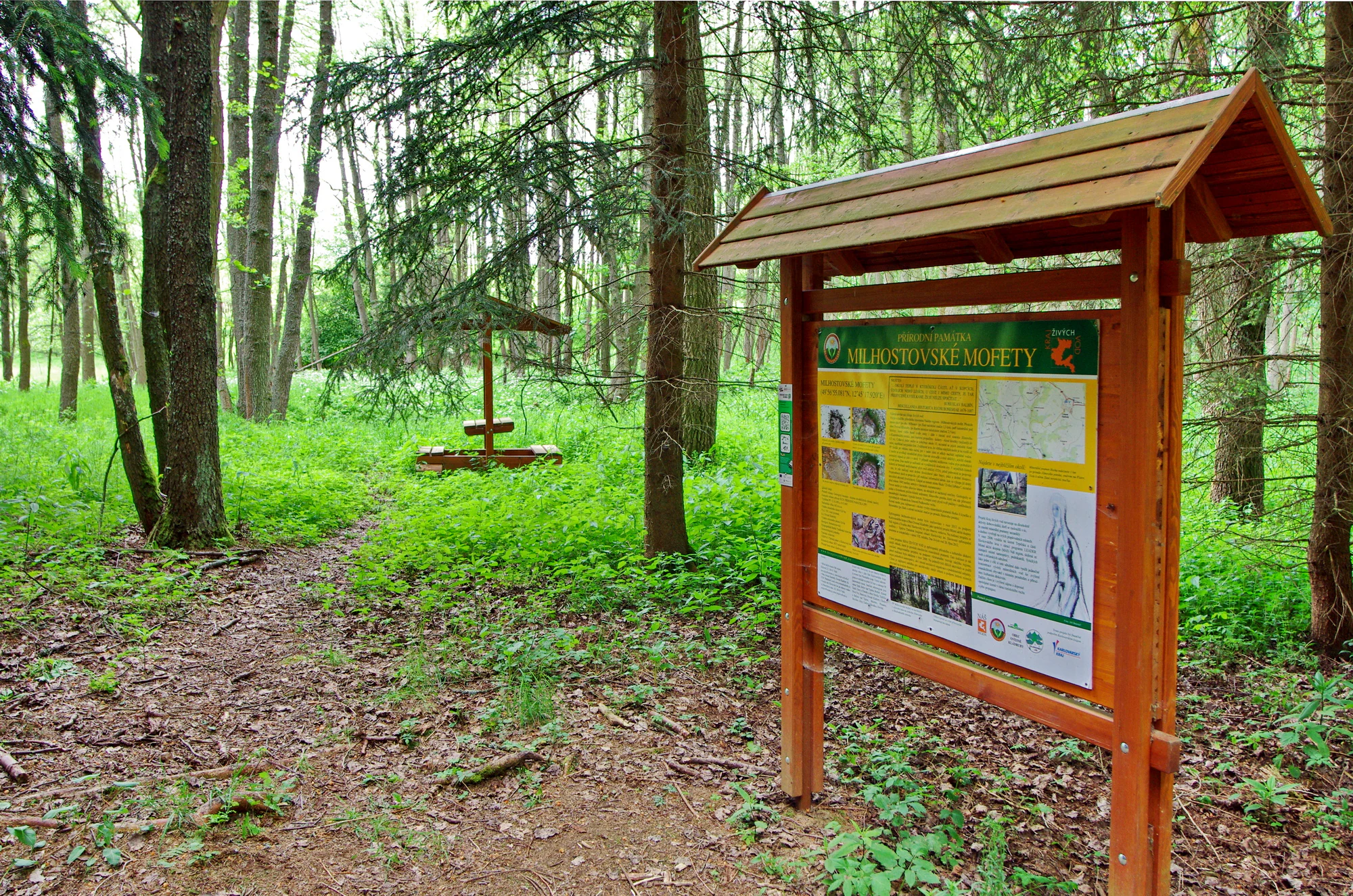
A wooden informational signboard stands on a dirt path in a lush green forest, with a small covered picnic area visible in the background.
An informational sign at the entrance to the Milhostovské mofety natural monument.

Milhostovské mofety history and protected-area timeline

Milhostovské mofety was formally designated as a přírodní památka on 12 October 1993, placing it under national-level protection within the Czech system of small protected natural sites. The designation was motivated specifically by the need to preserve an intact group of carbon-dioxide gas vents, mofettes, whose subsurface origin is tied to older tectonic structures and the volcanic history of the surrounding landscape.

Since its establishment, the site has been administered by the management authority of the Slavkovský les Protected Landscape Area, under which it now falls. This administrative connection reflects its geographical and geological position within a region where post-volcanic gas activity, mineral springs, and other deep-origin phenomena are widely documented across the broader Slavkov Forest. The natural monument's history is therefore less about a long human narrative and more about the modern Czech effort to recognize and protect a small but scientifically meaningful geological locality.

Milhostovské mofety landscape and geographic character

The physical setting of Milhostovské mofety is defined by a small, waterlogged valley floor rather than by dramatic topography. The site sits at roughly 620 meters above sea level in the floodplain of Jilmový potok, a minor stream whose valley is narrow, low-lying, and seasonally saturated. The overall terrain is gentle, with the surrounding land shaped by long-term drainage patterns and the underlying metamorphic bedrock.

Beneath the surface, the geological framework is more complex than the surface topography suggests. The bedrock consists of amphibolites belonging to the Mariánské Lázně metabasite complex, a metamorphosed sequence of volcanic and intrusive rocks. Gas reaches the surface through a network of fractures that combine older fault lines with younger fractures associated with the volcanic activity of nearby Podhorní vrch. The mofette craters themselves are shallow and subtle, often visible only as slight depressions in the wet ground rather than as dramatic openings in the landscape.

Milhostovské mofety ecosystems, habitats, and plant life

Ecologically, Milhostovské mofety represents a small but unusually specialized floodplain-forest ecosystem growing on top of an active geological phenomenon. The entire protected area lies within alder carr, a type of swampy lowland woodland dominated by alder, that flourishes on the permanently moist soils of the Jilmový potok floodplain. This hydrophilic forest community gives the site a shaded, damp character during much of the year.

A distinctive seasonal feature is the spring flora that emerges in the vicinity of the mofettes, where the combination of moisture, partial openings in the canopy, and unusual ground chemistry supports flowering populations of primrose (Primula elatior) and wood anemone (Anemone nemorosa). Even though the protected footprint is very small, the overlap of wetland conditions, gas-influenced soil chemistry, and a deciduous floodplain forest gives the locality a concentrated ecological identity that differs from the surrounding landscape.

Milhostovské mofety wildlife and species highlights

Mofette craters at Milhostovské mofety function as natural traps for small ground-dwelling fauna. Because the gas released is denser than air and accumulates in low depressions, the craters periodically capture and kill small rodents and beetles that wander into the vents. As a result, the mofettes are notable less as habitat for visible wildlife than as a hazard that shapes the local animal community in subtle ways.

The surrounding alder carr and stream corridor support the more typical wetland-forest fauna of the Slavkov Forest region. Birds, insects, and small mammals associated with moist deciduous woodland are characteristic of the area, while the mofette openings themselves contribute to a distinctive micro-ecology where the boundary between living conditions and toxic gas exposure is unusually close to the surface.

Milhostovské mofety conservation status and protection priorities

From a conservation standpoint, Milhostovské mofety is significant primarily as a protected example of post-volcanic gas activity within the broader Slavkovský les Protected Landscape Area. The site's mofettes represent a relatively rare type of geological phenomenon in the Czech context, and their preservation ensures that an intact, accessible example of this gas-emission system remains available for scientific study and monitoring.

The protection is also justified by the ecological mosaic that surrounds the vents. The alder floodplain woodland, the spring flora of primroses and wood anemones, and the wetland soils together create a small but coherent habitat complex closely tied to the same geological conditions that produce the gas vents. By safeguarding the vents and a generous protective buffer around them, the designation preserves not only the geological surface phenomenon but also the immediate ecological context in which it occurs.

Milhostovské mofety cultural meaning and human context

Milhostovské mofety does not have a strong standalone cultural narrative, but its location within the Slavkov Forest region connects it to a broader Bohemian cultural landscape marked by long association with mineral springs, mofettes, and other signs of deep geological activity. The surrounding villages, including Milhostov (part of the municipality of Zádub-Závišín) and Ovesné Kladruby, belong to a long-settled rural area where such geological features have historically been part of local environmental knowledge.

The site itself is purely a natural monument without built or commemorative heritage. Its cultural relevance lies primarily in how small natural monuments like this one fit into the Czech tradition of recognizing and protecting modest but scientifically meaningful features of the countryside as part of the national natural heritage system.

Top sights and standout views in Milhostovské mofety

Highlights of Milhostovské mofety include the cluster of carbon-dioxide mofettes, the small but well-preserved alder carr around Jilmový potok, and the seasonal blooms of primrose and wood anemone near the vents. Its amphibolite bedrock and fault-controlled gas pathways tie it directly to the deeper geological story of the Slavkov Forest region.

The site's compact 0.24-hectare protected core, framed by a 7.39-hectare protective zone, also makes it a clear example of how the Czech system protects highly localized geological and ecological phenomena that would otherwise be lost to land-use change.

Best time to visit Milhostovské mofety

Spring is generally the most rewarding season to experience the wider setting of Milhostovské mofety, because the floodplain forest around the vents is most visibly alive then. Primroses and wood anemones flower in the proximity of the mofettes during this period, and the alder woodland is at its freshest after winter.

Because the site is a small natural monument rather than a developed visitor area, the best approach is generally to visit in mild, dry weather when the ground is firm enough to walk on without damaging the sensitive wet soils. The vents themselves do not change dramatically with the seasons, but the surrounding woodland, stream, and flower display are at their most expressive in spring and early summer; late autumn and winter visits emphasize the bare, damp character of the valley floor.


Monthly climate preview

Long-term temperature ranges and monthly precipitation averages for Milhostovské mofety

Milhostovské mofety Climate Normals and Annual Weather Patterns

Historical data records monthly temperature swings from sub-zero winter minimums to warm summer maximums alongside steady precipitation rates. Detailed multi-year climatology tables provide complete month-by-month values for thorough environmental analysis.
Annual mean7 °C
-3 °C18 °C
Jan-3°
Feb-2°
Mar
Apr
May12°
Jun16°
Jul18°
Aug18°
Sep13°
Oct
Nov
Dec-2°
Warmest month
July

17.8 °C

Coolest month
January

-3.1 °C

Wettest month
July

2.7 mm/day

Driest month
April

1.4 mm/day

Park location guide

Geography guide, regional context, and park location map for Milhostovské mofety

Milhostovské mofety park geography, regions, and map view in Czechia

Understand where Milhostovské mofety sits in Czechia through a broader geographic reading of the surrounding landscape, nearby location context, and its mapped position within the national park landscape.

How Milhostovské mofety fits into Czechia

Czech Republic is a landlocked Central European country with a population of approximately 10.9 million people. The nation was established as an independent state on January 1, 1993, following the dissolution of Czechoslovakia. Its capital and largest city is Prague, with other major urban centers including Brno, Ostrava, Plzeň, and Liberec.

Wider geography shaping Milhostovské mofety in Czechia

The Czech Republic is a landlocked country in Central Europe. It is bordered by Germany to the west, Austria to the south, Poland to the northeast, and Slovakia to the southeast. The landscape is predominantly hilly, with the territory covering 78,871 square kilometers.

Map view of Milhostovské mofety

Use this park location map to pinpoint Milhostovské mofety in Czechia, understand its exact geographic position, and read its mapped placement within the surrounding landscape more clearly.

Pigeon | © OpenStreetMap contributors

Location context for Milhostovské mofety

Karlovarský kraj

Visual reference guide for carbon dioxide vents and wetland habitats

Milhostovské mofety Photos and Landscape Scenery

Milhostovské mofety photos capture the subtle valley terrain, waterlogged alder carr, and cold gas vent formations of the protected natural monument. Examining visual records reveals the unique post-volcanic landscape character and wetland ecology preserved within the Slavkov Forest region.

A wooden informational signboard stands on a dirt path in a lush green forest, with a small covered picnic area visible in the background.

Park atlas

Compare nearby regional reserves, post-volcanic sites, and related protected areas

Exploring Parks Near Milhostovské Mofety And Surrounding Protected Landscapes

Browsing other protected areas near Milhostovské mofety reveals a wider network of regional geological monuments and floodplain habitats. Comparing adjacent reserves helps place localized post-volcanic gas vents into a broader geographical context.
A soft, impressionistic watercolor painting depicting a wide, marshy landscape with green fields, low hills in the distance, and a small meandering stream.
Nature reserveKarlovarský kraj
About 5 km away#1 closest

North

Prameniště Teplé Nature Reserve: Protected Wetland and River Source Geography

A diverse springhead sanctuary in Karlovarský kraj

Prameniště Teplé stands as a significant nature reserve protecting the essential wetland mosaic surrounding the source of the Teplá River. Featuring a delicate balance of bogs, meadows, and forest fringes, this protected area preserves the ecological character of western Bohemian water-dominated landscapes through its unique spring-fed geography.

Area
0.429 km²
Established
1993
IUCN
IV
Relief
Upland
Natural monumentKarlovy Vary District
About 14 km away#2 closest

Northeast

Velikonoční rybník Natural Monument: Protected Wetland and Amphibian Habitat Geography

A core conservation site within the Slavkov Forest landscape

Velikonoční rybník stands as a noteworthy natural monument in the Karlovy Vary District, protecting essential wetland ecosystems. This small yet vital reservoir provides a specialized habitat for endangered amphibians and dragonflies, serving as a landmark of regional conservation efforts and ecological mapping within the Slavkov Forest region.

Area
0.018 km²
Established
2014
IUCN
IV
Relief
Upland
A stylized vector-style illustration showing a man and a child standing on the grassy bank of a pond, watching a swimmer in the middle of the water, with a waterfall and forest in the background.
Natural monumentKarlovarský kraj
About 19 km away#3 closest

North

Na Vážkách Natural Monument: Mapping Protected Forest Landscapes in Karlovarský kraj

A rare oligotrophic pond and wetland habitat in Western Bohemia.

Na Vážkách provides a unique example of small-scale landscape protection, featuring clear, sandy-bottomed waters within the broader forest mosaic of Karlovarský kraj. Designated in 2017, this natural monument is recognized for its significant dragonfly populations and its role in preserving historical aquatic water systems.

Area
0.026 km²
Established
2017
IUCN
III
Relief
Upland
Protected landscapeBavaria
About 26 km away#4 closest

Southwest

Naturpark Nördlicher Oberpfälzer Wald: Protected Landscape and Regional Geography Map

Forested upland terrain and volcanic geology in Bavaria

Explore the structured geography of Naturpark Nördlicher Oberpfälzer Wald, a massive protected region in Bavaria. This detailed profile highlights the park's characteristic ridge and valley terrain, volcanic basalt landmarks, and its role as a vital ecological belt along the international border.

Area
1,380 km²
Water
Minor water
Natural monumentKarlovarský kraj
About 27 km away#5 closest

Northeast

Viklan Natural Monument: A Geological Landmark in the Karlovarský kraj Landscape

Exploring the historic balancing granite boulder and surrounding pastoral terrain

Viklan functions as a compact yet iconic natural monument, shielding a prominent 3.5 meter granite boulder from modern disturbance. Set amidst the rolling, short-grass pastures of the Karlovarský kraj, the site serves as a vital point for geological mapping and historical study, documenting both natural weathering processes and long-standing regional folklore tied to this unusual stone formation.

Established
1979
IUCN
III
Relief
Upland
Access
Easy access
Nature reserveKarlovarský kraj
About 39 km away#6 closest

Northwest

Pomezní rybník Nature Reserve: Geographic Overview and Protected Wetland Boundaries

Borderland wetland ecology in the Karlovarský kraj region

Pomezní rybník represents a small but significant nature reserve known for its unique location where the state boundary bisects the central pond. The reserve provides a concentrated habitat for wetland species, featuring a rare botanical assemblage and transitional terrain between the lowland basin and highland slopes of the western Czech Republic.

Area
0.017 km²
Established
1990
Relief
Lowland
Scope
Terrestrial
A pale, soft watercolor illustration of a green meadow, a winding stream, and gentle, hazy rolling hills in the background.
Natural monumentPlzeň-sever District
About 39 km away#7 closest

East

Malenický pramen: Protected Natural Monument, Mining History, and Forest Geography

A study in mineral-rich hydrology and forested valley restoration

Located in the Plzeň-sever District, Malenický pramen is a site where geology and history intersect to create a distinctive protected habitat. The monument protects an iron-rich spring flowing through a steep forested valley, revealing traces of 19th-century pyrite mining. Its small, layered landscape serves as a focal point for understanding how mining heritage and forest ecology coexist within the broader framework of the Bohemian Massif's natural terrain.

Area
0.002 km²
Established
2010
IUCN
IV
Relief
Upland
Watercolor painting of columnar basalt formations surrounded by a pine forest and soft, layered hills in the background.
Natural monumentKarlovarský kraj
About 42 km away#8 closest

North

Rotava Natural Monument: Geological Landforms and Basalt Outcrops in the Karlovarský kraj Region

Protected volcanic terrain and rare botanical habitats in the Czech Republic

Rotava Natural Monument showcases remarkable vertical basalt columns formed by ancient volcanic activity. Located in the Karlovarský kraj region, this site provides a dense, concentrated look at columnar jointing and the specific meadow flora that thrives in its mineral-rich, acidic soil conditions, serving as a landmark for regional geological study.

Area
0.003 km²
Established
1978
IUCN
IV
Relief
Mountain

Common questions about visiting, size, designation, and location context for Milhostovské mofety

Milhostovské mofety FAQs for park facts, access, geography, and protected area context

Find quick answers about Milhostovské mofety, including protected-area facts, park geography, trail and visitor context, and how the park fits into its surrounding country and regional landscape.
MoriAtlas Explorer

Continue Your Protected Areas Search Across the Global Atlas

Deepen your exploration by continuing the structured search for national parks and protected areas worldwide. Utilize the comprehensive filtering capabilities to compare different conservation landscapes and refine your understanding of global park geography. Discover more about the distribution and characteristics of protected natural areas.

Global natural geography