Mori Atlas logo
Protected areaMili Atoll

Analyzing the geographic boundaries, coral atoll morphology, and historical island layout of the Ratak Chain

Mili Atoll: A Detailed Atlas Exploration of Marshall Islands Protected Landscapes and Terrain

Mili Atoll stands as a significant protected landscape in the Marshall Islands, encompassing 92 coral islets organized around a 760 square kilometer lagoon. This geographic analysis maps the atoll's low-lying terrain, characterized by narrow reef-fringed landforms and tidal connections between villages like Nallu and Enejet. Beyond its natural structure, the area serves as a profound historical site, featuring remnants of 20th-century fortifications that define the modern physical landscape of this remote Pacific expanse.

coral atollRatak ChainPacific OceanMarshall IslandsWWII historic sitelagoon ecosystem

Mili Atoll

Protected area

Park overview

Structured park overview, official facts, and landscape profile for Mili Atoll

Mili Atoll park facts, protected area profile, and essential visitor context

Review the core facts for Mili Atoll, including designation, size, terrain, visitor scale, habitats, and operating context in one park-focused overview.

About Mili Atoll

Mili Atoll occupies a distinctive place in the geography of the Marshall Islands. As part of the Ratak Chain, it lies in the North Pacific northeast of the country's more populated centers, with its 92 islets organized around a roughly oval reef system. The total land area of around 14.9 square kilometers is modest in absolute terms, but it is enough to make Mili the second-largest atoll in the country, outranked only by Kwajalein. Its lagoon, though much smaller than that of Kwajalein, still measures around 760 square kilometers and gives the atoll its characteristic enclosed-water character before the reef opens out to the open Pacific.

Settlement on Mili follows the classic pattern of atoll life in the Marshalls, with the population distributed across multiple small islets connected by reef flat and tidal channels. The main village of Mili is the administrative and population center, while Nallu, Enejet, Lukonor, Tokewa, and Wau form satellite communities. Some of these villages, including Nallu, Enejet and Lukonwor, are only reachable from Mili on foot during low tide, underscoring how strongly daily life on the atoll is shaped by the rhythms of the tide and reef. Air access is provided through Mili Airport and Enejit Airport, both of which are served by Air Marshall Islands when aircraft are available.

What sets Mili apart from many other Marshallese atolls is the sheer weight of its 20th-century history layered on top of a typical coral island setting. The atoll was designated as part of the Mulgrave Islands by the early 19th-century Russian navigator Adam Johann von Krusenstern, passed under German imperial claim in 1885, became a Japanese mandate possession after World War I, and was transformed into a major military installation during World War II. After the war it entered the U.S.-administered Trust Territory of the Pacific Islands and then joined the independent Republic of the Marshall Islands in 1986. This layered history, combined with the natural reef ecosystem and the ongoing life of Marshallese communities, gives Mili Atoll a profile that blends remote Pacific geography with a globally significant wartime past.

Quick facts and research context for Mili Atoll

Mili Atoll is a coral atoll of 92 islands in the Ratak Chain of the Marshall Islands, located about 78 kilometers southeast of Arno Atoll in the North Pacific. Its combined land area of around 14.9 square kilometers makes it the second-largest atoll in the Marshall Islands after Kwajalein, while it encloses a much smaller lagoon of roughly 760 square kilometers separated from neighboring Knox Atoll by the Klee Passage. The reported population is 497 (2021 census), centered on the main village of Mili with smaller communities on islets including Nallu, Enejet, Lukonor, Tokewa, and Wau.

Protection and recognition

Analysis of terrestrial protected area parameters and designation records

Mili Atoll Protection Status and Documented Conservation Framework

Terrestrial protected area records outline the conservation framework and management scope established for Mili Atoll. Verified administrative data details international recognition sources and designated status parameters across the protected landscape.

Protection details

Protection scope
Terrestrial
Transboundary protection
No
Park context

Deeper park guide and search-rich context for Mili Atoll

Mili Atoll history, landscape, wildlife, and travel context

Explore Mili Atoll through its history, landscape character, ecosystems, wildlife, conservation priorities, cultural context, and seasonal travel timing in a structured park guide built for atlas discovery and search intent.

Why Mili Atoll stands out

Mili Atoll is best known for its size and structure within the Marshall Islands, ranking as the country's second-largest atoll by land area despite enclosing a relatively small lagoon. It is equally known for its wartime legacy: a heavily fortified Japanese military base during World War II, complete with airfields, coastal defenses, and a large garrison, leaving the landscape today dotted with bunkers, artillery remnants, and aircraft wreckage. Its reef-fringed islets, traditional Marshallese villages, and remote Pacific setting round out its identity as both a living atoll community and a layered historical site.
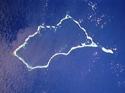
Aerial satellite photograph of Mili Atoll, a coral atoll forming an irregular ring shape with light turquoise and white reef edges surrounded by deep blue ocean water
Satellite view of Mili Atoll showing the coral ring structure and surrounding deep blue ocean in the Marshall Islands

Mili Atoll history and protected-area timeline

European and early Pacific contact with Mili Atoll began in the early 19th century. The British merchant vessel Rolla, transporting convicts from Britain to New South Wales and then sailing on to Canton, sighted islands in the Ratak and Ralik chains in October 1803; records suggest the sighting may have included what is now Mili. A landing attempt failed due to heavy surf, but the atoll was subsequently charted by Adam Johann von Krusenstern in the early 1800s, who grouped Mili and Knox together under the name Mulgrave Islands.

In 1823 the atoll entered Pacific maritime history through the American whaleship Globe, whose mutinous crew, led by Samuel B. Comstock, brought the vessel to Mili after killing the captain and three officers. Comstock himself was murdered by a fellow mutineer on the atoll; the remaining stranded crew were eventually reduced to two survivors by the time the U.S. schooner Dolphin, under Lieutenant Commander John Percival, rescued them two years later. The notorious blackbirder Bully Hayes later owned Tokowa Islet on Mili in the late 19th century, using it as a base for his operations across the western Pacific. In 1885, the atoll was formally claimed by the German Empire along with the rest of the Marshall Islands.

After World War I, Mili passed to the Empire of Japan under the South Seas Mandate and was turned into a major military outpost. The Japanese built a radio direction-finding beacon, a weather station, an airfield with three runways between late 1942 and late 1943, a seaplane base, a radar station, and extensive coastal and anti-aircraft defenses. Garrison strength grew to several thousand Imperial Japanese Navy and Army personnel, and Korean and Marshallese forced laborers, including around 800 to 1,000 Koreans, were brought to the atoll to support construction.

Between mid-1943 and August 1945 Mili was repeatedly bombed by United States Navy carrier aircraft and shelled by warships, with attacks intensifying after Majuro and Kwajalein fell to U.S. forces. Roughly half of the approximately 5,100-strong Japanese garrison survived to the end of the war, and the garrison commander formally surrendered on board the USS Levy on 22 August 1945. Reports published from 2010 onward also describe grim wartime events on Mili, including testimony concerning forced cannibalism of Korean laborers and a subsequent Korean rebellion that was suppressed with executions and mass suicides, with around 218 Koreans reportedly dying on the atoll between 1942 and 1945.

Following the war, Mili became part of the Trust Territory of the Pacific Islands under United States administration, and since 1986 it has been part of the independent Republic of the Marshall Islands. The landscape still bears the visible marks of this period: bunker systems, rail systems, old artillery pieces, Japanese Mitsubishi A6M Zero aircraft, a wrecked Nakajima B5N, a Mitsubishi G4M, wrecked Lockheed P-38 Lightnings, a North American B-25 Mitchell in shallow water, and widespread craters from pre-invasion bombardment. While Peace Corps volunteers destroyed thousands of unexploded munitions in the 1960s, residual chemicals from Japanese and American munitions continue to pose environmental concerns on land and in the surrounding ocean.

Mili Atoll landscape and geographic character

Mili Atoll is a classic Pacific coral atoll, formed from 92 low-lying islets arranged around an approximately oval reef. Land elevations across the atoll are extremely low, peaking at only about 3 meters above sea level, reflecting the typical morphology of atolls built up from coral on top of subsiding volcanic foundations. The cumulative land area is around 14.9 square kilometers, distributed across numerous small islands rather than concentrated in a single landmass.

The atoll encloses a lagoon of roughly 760 square kilometers, an order of magnitude larger than the dry land area but considerably smaller than the massive lagoon of neighboring Kwajalein. To the southeast, Mili is separated from the smaller Knox Atoll by the Klee Passage, a navigable water channel that defines part of the atoll's outer geography. The reef flat, tidal margins, and sheltered lagoon waters together shape the surface environment of Mili, while fringing reef ecosystems border every islet that makes up the ring of land.

Because the islands are flat and narrow, inter-village connections depend heavily on reef exposure. Several villages, including Nallu, Enejet and Lukonwor, are reachable from Mili only by foot during low tide, when the reef flat is briefly exposed. The overall landscape impression is therefore one of scattered green islets, white sand and coral, turquoise lagoon water, and a persistent horizon line of open ocean beyond the reef.

Mili Atoll ecosystems, habitats, and plant life

Mili Atoll's natural environment is built around the typical ecosystems of a central Pacific coral atoll: fringing and barrier reef communities, a sheltered lagoon, sandy coral islets, and the small patches of vegetation that sustain human habitation on such low-lying land. The 92 islets collectively form a ring of habitat around a relatively open lagoon, with reef flat exposures that appear and disappear with the tide. As elsewhere in the Ratak Chain, the ecosystems are marine-dominated, with terrestrial habitats limited to narrow strips of coconut and breadfruit-bearing land, salt-tolerant strand vegetation, and small wetland or taro cultivation areas where soils allow.

The broader ecological importance of Mili lies in its position within the Ratak Chain and its size: as the second-largest atoll in the Marshall Islands by land area, it sustains a meaningful fraction of the country's reef and lagoon habitat. The surrounding ocean and lagoon waters are part of migratory pathways for pelagic fish, marine mammals, and seabirds, while the reef structures themselves provide habitat for reef fish, sharks, and other Pacific marine life. Conservation interest in atolls like Mili focuses on reef health, lagoon water quality, coastal resilience to sea-level rise, and the management of contamination legacies from decades of military use.

Mili Atoll wildlife and species highlights

Mili's wildlife profile is overwhelmingly marine and coastal. The fringing reefs and 760-square-kilometer lagoon support reef fish assemblages typical of the central Pacific, along with larger pelagic species that move through surrounding waters. The reef flats and shallow lagoon margins provide feeding grounds for seabirds and wading shorebirds, while the scattered islets offer limited but important nesting habitat. Marine mammals recorded in wider Marshall Islands waters, including cetaceans, also pass through the broader sea area around Mili.

On land, terrestrial fauna is restricted by the small size and low elevation of the islets, but includes the usual complement of Pacific atoll species such as coconut crabs, hermit crabs, and various shorebirds. The combination of abundant reef habitat, productive lagoon waters, and remote location means that Mili, like other Ratak atolls, plays a role in sustaining regional seabird and reef-fish populations in an ocean area that has historically seen limited large-scale human pressure outside specific zones.

Mili Atoll conservation status and protection priorities

From a conservation perspective, Mili Atoll's significance lies in both its environmental value and its contamination challenges. Its reef and lagoon systems, together with the surrounding Pacific waters, contribute to the overall marine biodiversity of the Ratak Chain and the broader Marshall Islands. At the same time, the atoll's role as a heavily fortified Japanese military base during World War II and subsequent target of U.S. naval bombardment left a long environmental legacy. Unexploded munitions on land and in the ocean continue to pose risks, and chemicals leached from these munitions can enter the marine food chain.

In the 1960s, Peace Corps volunteers destroyed thousands of unexploded rounds on the atoll, reducing immediate hazards, but residual contamination concerns persist. Marshallese law now prohibits the removal of wartime relics from the island, effectively keeping the wrecks and bunkers in place as both a historical archive and an unresolved environmental liability. Conservation management of Mili thus sits at the intersection of reef and lagoon ecosystem protection, coastal resilience in the face of climate and sea-level change, and the long-term remediation of military contamination.

Mili Atoll cultural meaning and human context

Mili Atoll's cultural identity is rooted in traditional Marshallese atoll life. Population is overwhelmingly Marshallese, organized across multiple villages including the main settlement of Mili and smaller communities on Nallu, Enejet, Lukonor, Tokewa, and Wau. Inter-village movement is shaped by the reef, with several satellite villages reachable only on foot at low tide, reinforcing the close relationship between community structure and tidal rhythms. Education is provided through local elementary schools on the atoll, with secondary education centered on Majuro at Marshall Islands High School.

The atoll also carries a complex and sometimes painful layer of outside cultural encounters. Nineteenth-century contact with foreign ships left traces, including the visit of the whaleship Globe in 1823 and later the activities of Bully Hayes on Tokowa Islet in the late 1800s. The German and Japanese imperial periods followed, and the wartime experiences of both Marshallese people and the Korean forced laborers brought to the atoll are now part of its broader cultural memory. Notable residents include Marshallese weightlifter Mattie Sasser, placing Mili within the contemporary sporting identity of the Marshall Islands.

Top sights and standout views in Mili Atoll

Mili Atoll stands out for its sheer scale within the Marshall Islands, ranking as the country's second-largest atoll by land area while enclosing a 760-square-kilometer lagoon. Its 92 reef-fringed islets and the tidal connections between them support a distributed pattern of Marshallese village life that remains tied to the rhythms of the sea. Historically, the atoll is notable for its layered past: an early 19th-century sighting by the British vessel Rolla, the Globe mutiny of 1823, the activities of Bully Hayes, German and then Japanese imperial rule, and a heavily fortified World War II garrison that underwent sustained U.S. naval bombardment.

Best time to visit Mili Atoll

Like other atolls in the Ratak Chain, Mili experiences a tropical climate with relatively stable temperatures year-round and a pattern of wetter and drier periods rather than the four-season cycle found at higher latitudes. The calmer, drier months generally offer the most settled conditions for travel, reef exploration, and inter-islet movement, while wetter periods can bring heavier swells and reduced visibility on outer reefs.

Because the atoll is extremely low-lying and accessible only by small aircraft and sea connections, the practical window for a visit is closely linked to weather and sea conditions. Visitors interested in the wartime relics, village life, and reef environments typically find that the drier season offers more reliable lagoon conditions, calmer reef flats, and better conditions for moving between villages such as Mili, Nallu, Enejet, Lukonor, Tokewa, and Wau.


Monthly climate preview

Long term monthly temperature and precipitation averages for Mili Atoll in the Marshall Islands

Mili Atoll Climate Normals, Annual Temperature and Precipitation Rhythm

Historical climate data from representative park coordinates records consistent monthly temperatures alongside steady precipitation patterns throughout the year. Reviewing the complete twelve month profile provides deeper insight into measured long term weather averages for Mili Atoll.
Annual mean28 °C
28 °C28 °C
Jan28°
Feb28°
Mar28°
Apr28°
May28°
Jun28°
Jul28°
Aug28°
Sep28°
Oct28°
Nov28°
Dec28°
Warmest month
November

28.2 °C

Coolest month
February

27.9 °C

Wettest month
April

9.1 mm/day

Driest month
February

5.8 mm/day

Park location guide

Geography guide, regional context, and park location map for Mili Atoll

Mili Atoll park geography, regions, and map view in Marshall Islands

Understand where Mili Atoll sits in Marshall Islands through a broader geographic reading of the surrounding landscape, nearby location context, and its mapped position within the national park landscape.

How Mili Atoll fits into Marshall Islands

The Marshall Islands is a sovereign island nation in Oceania, located in the Micronesia region of the Northwestern Pacific Ocean. The territory consists of 29 coral atolls and five main islands plus over 1,200 very small ones, divided across two island chains: Ratak in the east and Ralik in the west. The country gained independence from the United States in 1979 and maintains a Compact of Free Association with the US. It is notable for having the highest proportion of water to land of any sovereign state, at 98.62%.

Wider geography shaping Mili Atoll in Marshall Islands

The Marshall Islands is located in the Micronesia region of the Northwestern Pacific Ocean, west of the International Date Line and north of the equator. The territory is composed of 29 coral atolls and five main islands, plus approximately 1,220 very small islets, divided into two island chains: Ratak (eastern) and Ralik (western). Maritime boundaries are shared with Wake Island to the north, Kiribati to the southeast, Nauru to the south, and the Federated States of Micronesia to the west.

Map view of Mili Atoll

Use this park location map to pinpoint Mili Atoll in Marshall Islands, understand its exact geographic position, and read its mapped placement within the surrounding landscape more clearly.

Pigeon | © OpenStreetMap contributors

Location context for Mili Atoll

Ratak Chain

Explore real imagery of low-lying islets, lagoon waters, and historic coastal terrain.

Mili Atoll Photos and Scenery: Visualizing Pacific Coral Reef Landscapes

Visual records capture the low-lying coral islets, extensive lagoon waters, and wartime remnants that define the remote island geography of Mili Atoll. Studying these authentic protected-area photographs provides deeper insight into the fragile reef ecosystems and historical terrain of the Marshall Islands.

Aerial satellite photograph of Mili Atoll, a coral atoll forming an irregular ring shape with light turquoise and white reef edges surrounded by deep blue ocean water

Park atlas

Discover related Pacific coral atolls and connected island ecosystems.

Explore Parks Near Mili Atoll and Regional Protected Areas

Browse protected areas near Mili Atoll to compare remote coral formations and regional lagoon geography. Regional park comparisons reveal shared marine habitats across the Ratak Chain.
Protected areaMarshall Islands
About 108 km away#1 closest

North

Arno Atoll: A Rare Triple Lagoon Coral Protected Area in the Marshall Islands

Mapped geography and hydrological landscape context

Arno Atoll stands out as a unique geographic entity in the Ratak Chain with its triple lagoon configuration. Spanning 133 islands in the North Pacific, this protected area offers insight into atoll reef systems, low lying coral landscapes, and the environmental framework of the Marshall Islands.

Area
13 km²
Relief
Lowland
Climate
Tropical
Scope
Mixed
A watercolor painting showing a panoramic view of soft, green rolling hills, a cluster of trees, and a calm water surface in a light, muted palette.
Protected areaMarshall Islands
About 121 km away#2 closest

Northwest

Majuro: Mapping the Protected Coral Atoll Landscapes and Island Geography of the Marshall Islands

Regional atoll atlas and protected lagoon geography.

Majuro serves as the primary administrative and geographic anchor within the Marshall Islands. This detailed mapping showcases the atoll's signature structure, characterized by 64 narrow islets enclosing a massive, sheltered 295 square kilometer lagoon. Delve into the specific landforms and regional marine geography that define this Pacific protected environment.

Area
9.7 km²
Relief
Lowland
Climate
Tropical
Access
Moderate access
Nature reserveMarshall Islands
About 253 km away#3 closest

West

Jaluit Atoll Nature Reserve: Protected Coral Landscapes in the Marshall Islands

Coastal reef and lagoon geography of the Ralik Chain

Jaluit Atoll constitutes a sprawling nature reserve in the Marshall Islands, characterized by its kite shaped lagoon and 91 low lying coral islets. As a recognized Ramsar wetland site, this protected area offers a deep look into Pacific atoll structure and the interplay between marine conservation and historical heritage. The atoll remains a central geographic feature of the Ralik Chain.

Area
11.34 km²
Established
2004
Relief
Lowland
Climate
Tropical
Protected areaMarshall Islands
About 425 km away#4 closest

West

Namdrik Atoll Protected Area: Geography and Coastal Ecosystems in the Marshall Islands

A remote Ramsar-recognized coral atoll and marine wetland.

Namdrik Atoll is a distinctive coral atoll within the Ralik Chain of the Marshall Islands, recognized for its exceptional mangrove forests and protected marine ecosystems. This area consists of two wooded islands enclosing a large lagoon without navigable passes, creating an isolated habitat for sea turtles and diverse reef life. Explore the geography of this small, ecologically significant protected land that represents the unique environmental character of the central Pacific.

Area
2.8 km²
Established
2012
Relief
Lowland
Climate
Tropical
Protected areaMarshall Islands
About 513 km away#5 closest

Northwest

Ailuk Atoll Protected Area: Geography and Mapped Coral Landscapes in the Marshall Islands

Pacific atoll terrain, lagoon systems, and island geography

Study the geographic composition of Ailuk Atoll, featuring its classic ring of coral islets, deep-water reef passes, and vast central lagoon. This protected area offers insight into the subsidence-driven formation of Marshallese island chains and the enduring human reliance on traditional maritime navigation within a fragile Pacific ecosystem.

Area
5.4 km²
Relief
Lowland
Climate
Tropical
Access
Remote access
Watercolor painting of a landscape showing a body of water surrounded by green land with trees and distant hills, with soft pink and purple washes on the sides
Protected areaMarshall Islands
About 517 km away#6 closest

Northwest

Likiep Atoll: A Mapped Protected Area in the Marshall Islands Ratak Chain

Coral atoll geography and historical colonial landscape features

Likiep Atoll consists of 65 islands encircling a 424 square kilometer lagoon. As a protected area in the Marshall Islands, it offers insight into low lying atoll topography, unique marine environments, and the cultural remnants of successive colonial administrations.

Area
10.26 km²
Relief
Lowland
Climate
Tropical
Access
Remote access
A pale, soft watercolor illustration depicting distant islands or atoll ridges across a calm lagoon, with silhouetted palm trees in the foreground on the left and right.
Protected areaMarshall Islands
About 543 km away#7 closest

Northwest

Kwajalein Atoll Protected Area and Marshall Islands Geographic Landscape Mapping

Pacific coral atoll structure and lagoon geography

Kwajalein Atoll represents a mature coral formation encompassing an immense lagoon within the Ralik Chain. The landscape consists of low-lying islets and interconnected reef structures that define the maritime geography of the Marshall Islands. This assessment provides a focus on the structural, mapped, and physical attributes that distinguish this protected site within the wider Pacific regional context.

Area
16.4 km²
Relief
Lowland
Climate
Tropical
Access
Highly restricted
Protected areaMarshall Islands
About 703 km away#8 closest

North

Bikar Atoll Protected Area: Geographic Overview of a Remote Marshall Islands Coral Atoll

A pristine, uninhabited coral sanctuary and critical Pacific marine habitat.

Bikar Atoll is a remote, diamond-shaped coral ring located in the Ratak Chain of the Marshall Islands. Defined by its shallow lagoon, continuous reef structure, and arid islets, the atoll serves as a vital nesting site for seabirds and green turtles. This protected area remains one of the most ecologically undisturbed sites in the Pacific, offering rare insight into natural atoll morphology and island conservation.

Area
0.5 km²
Established
2025
Relief
Lowland
Climate
Tropical

Common questions about visiting, size, designation, and location context for Mili Atoll

Mili Atoll FAQs for park facts, access, geography, and protected area context

Find quick answers about Mili Atoll, including protected-area facts, park geography, trail and visitor context, and how the park fits into its surrounding country and regional landscape.
MoriAtlas Explorer

Continue Your Protected Areas Search Across the Global Atlas

Deepen your exploration by continuing the structured search for national parks and protected areas worldwide. Utilize the comprehensive filtering capabilities to compare different conservation landscapes and refine your understanding of global park geography. Discover more about the distribution and characteristics of protected natural areas.

Global natural geography