

Mori Atlas logo
State or regional parkMitlenatch Island Nature Provincial Park

Understanding the mapped boundaries and island terrain within the Strait of Georgia protected area network

Mitlenatch Island Nature Provincial Park: An Atlas of Protected Coastal Landscapes and Marine Geography

Mitlenatch Island Nature Provincial Park functions as a dedicated ecological sanctuary located within the northern Strait of Georgia of British Columbia. This protected landscape encompasses both rocky terrestrial uplands and extensive marine foreshore zones, providing essential habitat for colonial seabirds and marine mammals. The park geography reflects a compact Gulf Island environment shaped by maritime exposure, serving as a critical node in the regional conservation network of western Canada.

islandseabird colonymarine sanctuarycoastalGulf IslandsIUCN strict nature reserve

Mitlenatch Island Nature Provincial Park

State or regional park

Park overview

Structured park overview, official facts, and landscape profile for Mitlenatch Island Nature Provincial Park

Mitlenatch Island Nature Provincial Park park facts, protected area profile, and essential visitor context

Review the core facts for Mitlenatch Island Nature Provincial Park, including designation, size, terrain, visitor scale, habitats, and operating context in one park-focused overview.

About Mitlenatch Island Nature Provincial Park

Mitlenatch Island Nature Provincial Park occupies a small but strategically located island in the northern Strait of Georgia, placing it at the heart of one of British Columbia's most biologically productive marine corridors. Although its total area of 155 hectares is modest, the park is split between roughly 36 hectares of grassy and rocky upland and about 119 hectares of foreshore waters, reflecting a deliberate conservation design that treats the surrounding sea as an integral part of the protected landscape.

Established as a Provincial Nature Park in 1961 after the British Columbia government purchased the island from a local family in 1959, the site has long been recognized as a critical seabird and marine mammal refuge. Its IUCN Category Ia designation as a strict nature reserve underscores the management philosophy of minimal intervention: protecting ecological processes rather than accommodating heavy public use. The result is a sanctuary where natural rhythms, breeding cycles, and seasonal movements of wildlife take precedence over recreation.

For visitors, Mitlenatch is defined as much by what it excludes as by what it offers. Access is possible only by boat, and the interior of the island is largely off-limits to shield nesting birds from disturbance. Short permitted routes between Camp Bay and Northwest Bay, together with a designated East Hill gull blind, provide rare points of entry into a landscape that otherwise remains in the custody of the wildlife it was created to protect.

Quick facts and research context for Mitlenatch Island Nature Provincial Park

Mitlenatch Island Nature Provincial Park protects 155 hectares of land and sea in the northern Strait of Georgia, about 30 kilometres northeast of Courtenay, British Columbia. The protected area is composed of approximately 36 hectares of upland island habitat and around 119 hectares of surrounding foreshore, giving the relatively small landmass an outsized marine conservation footprint. The park was established in 1961, two years after the province purchased the island from a private owner, and is classified as a strict nature reserve under the IUCN protected-area framework.

The site is a year-round haven for seabirds and marine mammals, with breeding colonies, haul-out beaches, and intertidal feeding grounds concentrated within its boundaries. Access is strictly controlled; the island is boat-access only, and most of the interior is closed during the breeding season to protect sensitive nesting habitat.

Protection and recognition

Review documented protection history and management scope for Mitlenatch Island Nature Provincial Park

Mitlenatch Island Nature Provincial Park Protection Status and History

Mitlenatch Island Nature Provincial Park carries a documented mixed protection status established in 1961 for regional conservation. Review official designation records and administrative framework details compiled for this protected area.

Protection details

Protection scope
Mixed
Designated year
1961
Transboundary protection
No
WDPA ID
4324076
Park context

Deeper park guide and search-rich context for Mitlenatch Island Nature Provincial Park

Mitlenatch Island Nature Provincial Park history, landscape, wildlife, and travel context

Explore Mitlenatch Island Nature Provincial Park through its history, landscape character, ecosystems, wildlife, conservation priorities, cultural context, and seasonal travel timing in a structured park guide built for atlas discovery and search intent.

Why Mitlenatch Island Nature Provincial Park stands out

Mitlenatch Island Nature Provincial Park is most famous for being the largest seabird breeding colony in the Strait of Georgia, drawing thousands of nesting birds to its rocky shores each spring. The park's combination of grass-topped uplands, rugged shoreline cliffs, and sheltered bays creates an unusually dense gathering point for species such as glaucous-winged gulls, pelagic cormorants, pigeon guillemots, rhinoceros auklets, and black oystercatchers. Equally distinctive is the park's dual terrestrial and marine character: a small island paired with an extensive foreshore zone that protects sedentary marine life like abalones, scallops, and sea cucumbers, while also serving as a seasonal haul-out for Steller and California sea lions. The presence of unusually large western terrestrial garter snakes adds another layer of biological interest, making the park a compact showcase of coastal Gulf Island wildlife.
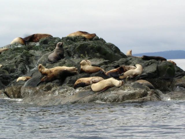
A group of sea lions resting on a dark rocky island surrounded by water, with a cloudy sky and distant land visible in the background.
A colony of sea lions resting on a rocky outcrop surrounded by ocean waters under an overcast sky.

Mitlenatch Island Nature Provincial Park history and protected-area timeline

Mitlenatch Island was purchased by the province of British Columbia in 1959 from a family that had previously held title to the small islet. Just two years later, on July 14, 1961, the island was formally designated as a Provincial Nature Park, recognizing both its ecological significance and the need to keep it largely undisturbed by development or heavy public use.

The name 'Mitlenatch' itself reflects deep Indigenous engagement with the surrounding seascape. It is a Coast Salish First Nations word commonly translated as 'calm waters all around', a description that fits the island's sheltered position during rough weather in the Strait of Georgia. A more granular interpretation comes from the Sliammon language, where 'metl' referred to calm and 'nach' to 'behind', yielding the phrase 'calm (waters) behind', an apt name for a refuge island that remains tranquil even when storms sweep the broader strait. In the Kwak'wala language of the Kwakwaka'wakw people, a related term, 'mah-kwee-lay-lah', conveys the idea that the island looks close but seems to retreat as one approaches, hinting at the optical illusions created by the surrounding waters.

Mitlenatch Island Nature Provincial Park landscape and geographic character

Mitlenatch is a compact Gulf Island-type landscape shaped by salt water, wind, and exposure. Its roughly 36 hectares of upland rise from the sea in a mix of grassy knolls, rocky outcrops, and low cliff faces, with the rest of the protected area consisting of the surrounding 119 hectares of foreshore. The terrain is too small and rugged to host dense forest, and instead features open communities of grasses and hardy coastal vegetation that can withstand the maritime climate.

The shoreline is the defining feature of the island, with rocky beaches, tidal pools, coves such as Camp Bay and Northwest Bay, and elevated vantage points like East Hill that look out over the Strait of Georgia. During stormy weather, the surrounding strait can turn rough, yet the island itself often lies in comparatively calm water, living up to the meaning of its name. This contrast between exposed outer waters and sheltered lee conditions has helped shape both the cultural memory of the place and the way its habitats have evolved.

Mitlenatch Island Nature Provincial Park ecosystems, habitats, and plant life

The park's ecological character is a tightly woven blend of marine and terrestrial habitats compressed into a small geographic footprint. Above the tideline, the island's open, wind-swept vegetation provides critical nesting substrates for colonial seabirds, while the rocky intertidal zone is rich with the sedentary marine species that the park's foreshore designation is intended to safeguard.

Below and around the island, the cold, plankton-rich waters of the Strait of Georgia support a productive food web. Tide pools and shallow nearshore areas harbor small fish, sculpins, and blennies, which in turn feed the snakes and birds that hunt along the shoreline. The combination of intact upland nesting habitat, a fully protected foreshore, and clean surrounding waters makes the park an unusually dense concentration of habitat types in a very small area.

Mitlenatch Island Nature Provincial Park wildlife and species highlights

Mitlenatch Island Nature Provincial Park is best understood through the sheer density and diversity of its wildlife in such a small area. Each spring, the island becomes a hub of seabird activity, hosting what is widely recognized as the largest seabird colony in the Strait of Georgia. Glaucous-winged gulls form noisy, visible aggregations across the grassy uplands, while pelagic cormorants, pigeon guillemots, rhinoceros auklets, and black oystercatchers occupy rocky ledges, crevices, and shoreline nooks.

Marine mammals are an equally important part of the park's fauna. Harbour seals use the sheltered bays throughout the year, and the island is a favorite haul-out for both Steller (northern) and California sea lions, which are typically present from late autumn through mid-May. River otters are regularly observed along the shore, and offshore visitors sometimes include killer whales and harbour porpoises passing through the surrounding strait. On land, the park is also notable for some of the largest western terrestrial garter snakes in British Columbia, which hunt small fish in tide pools and along the beach, sometimes surprising visitors on the limited walking trails.

Mitlenatch Island Nature Provincial Park conservation status and protection priorities

Mitlenatch Island Nature Provincial Park plays an outsized conservation role relative to its size by concentrating protection across both terrestrial and marine environments in a region of intense human activity along the British Columbia coast. Its IUCN Category Ia status as a strict nature reserve signals a management approach centered on ecological integrity rather than visitor accommodation, with most of the island closed to the public during the sensitive breeding season.

A defining element of the park's conservation value is the comprehensive protection afforded to sedentary marine life within its foreshore area. Species such as abalones, scallops, and sea cucumbers are fully protected inside the zone, providing a refuge in a body of water where such species have faced widespread pressure. At the same time, the park preserves one of the Strait of Georgia's most important seabird breeding assemblages and supports marine mammal populations that rely on the island for resting and breeding. Together, these qualities make Mitlenatch a small but disproportionately important node in the broader network of protected areas along Canada's Pacific coast.

Mitlenatch Island Nature Provincial Park cultural meaning and human context

The cultural significance of Mitlenatch Island stretches back long before its formal protection. As a Coast Salish place name, and one echoed with related terms in the Sliammon and Kwak'wala languages of the Kwakwaka'wakw, the island reflects an intimate Indigenous knowledge of the local seascape, its moods, and its visual quirks. Multiple First Nations languages have layered observations onto the same small piece of land: a sense of sheltered calm behind the island during storms, and the curious way it seems to recede as one sails toward it.

The island's subsequent transition from private family ownership to provincial purchase in 1959, and its designation as a nature park in 1961, mark an important shift toward modern conservation values, but they did not erase the cultural memory embedded in its name. Today, Mitlenatch stands as a place where Indigenous place-naming traditions, mid-twentieth-century conservation thinking, and contemporary ecological management intersect on a single small island.

Top sights and standout views in Mitlenatch Island Nature Provincial Park

Mitlenatch Island Nature Provincial Park's standout quality is the way an exceptionally small island supports a remarkably full slice of Strait of Georgia wildlife, from nesting seabirds on the grassy uplands to sea lions hauled out on rocky beaches and tide pool communities sheltered along the shore. The park's strict nature reserve status and seasonal access restrictions amplify this richness by keeping disturbance to a minimum during the most sensitive periods of the year.

Another highlight is the blend of cultural and natural significance: the Coast Salish name captures the character of the waters around the island, while modern conservation policy has translated that long-standing respect for the place into a legally protected refuge for birds, marine mammals, and intertidal life.

Best time to visit Mitlenatch Island Nature Provincial Park

Timing a visit to Mitlenatch is largely shaped by the wildlife calendar rather than by personal comfort. Late spring and early summer are the most ecologically active periods, when seabird colonies are at their peak and the island hums with breeding activity; this is also when access restrictions are tightest, since most of the island is closed to protect nesting birds. Late autumn through mid-spring tends to be the season when sea lions are reliably hauled out along the shore, and visitor use is generally more in step with marine mammal viewing than with seabird breeding.

Weather and sea conditions matter as much as wildlife timing. The Strait of Georgia can be rough and unpredictable outside the sheltered lee of the island, so calmer days with settled marine forecasts are more rewarding for the boat crossing and for exploring the small shoreline areas that remain accessible. Visitors who go primarily for seabird spectacle should aim for the breeding window with awareness that areas may be closed, while those drawn to marine mammals often find winter and shoulder seasons a quieter and productive alternative.
Monthly climate preview

Long term temperature ranges and monthly precipitation distributions for regional conservation analysis

Mitlenatch Island Nature Provincial Park Climate Normals and Annual Weather Patterns

Representative coordinate records show measured monthly temperature variations and precipitation distributions across the protected landscape from 1991 to 2020. Reviewing the complete twelve month climate normal dataset provides deeper analytical context for long term environmental research.
Annual mean9 °C
1 °C17 °C
Jan
Feb
Mar
Apr
May11°
Jun14°
Jul17°
Aug17°
Sep14°
Oct
Nov
Dec
Warmest month
July

16.9 °C

Coolest month
December

1.3 °C

Wettest month
November

7 mm/day

Driest month
July

1.6 mm/day

Park location guide

Geography guide, regional context, and park location map for Mitlenatch Island Nature Provincial Park

Mitlenatch Island Nature Provincial Park park geography, regions, and map view in Canada

Understand where Mitlenatch Island Nature Provincial Park sits in Canada through a broader geographic reading of the surrounding landscape, nearby location context, and its mapped position within the national park landscape.

How Mitlenatch Island Nature Provincial Park fits into Canada

Canada is a federal parliamentary constitutional monarchy spanning North America from the Atlantic to the Pacific and Arctic Oceans. With a population of over 41 million, it is officially bilingual in English and French at the federal level. The country gained independence from the United Kingdom through a gradual process culminating in 1982.

Wider geography shaping Mitlenatch Island Nature Provincial Park in Canada

Canada occupies the northern portion of North America, sharing its longest international border with the United States. The country extends from the Atlantic Ocean to the Pacific Ocean and northward into the Arctic Ocean, giving it the longest coastline of any nation.

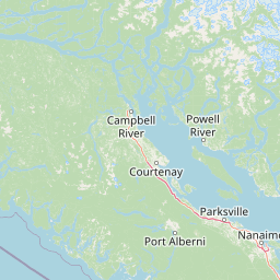
Map view of Mitlenatch Island Nature Provincial Park

Use this park location map to pinpoint Mitlenatch Island Nature Provincial Park in Canada, understand its exact geographic position, and read its mapped placement within the surrounding landscape more clearly.

Pigeon | © OpenStreetMap contributors

Location context for Mitlenatch Island Nature Provincial Park

British Columbia

Visualizing the rugged coastal terrain, rocky shorelines, and protected marine habitats of a strict island nature reserve

Mitlenatch Island Nature Provincial Park Photos and Landscapes

Visual records capture the rugged terrain, grassy uplands, and rocky shorelines that define the protected landscape of Mitlenatch Island Nature Provincial Park. Photographic exploration reveals the visual character of its marine foreshore and seabird habitats without requiring physical access.

A group of sea lions resting on a dark rocky island surrounded by water, with a cloudy sky and distant land visible in the background.

Park atlas

Compare coastal sanctuaries, marine reserves, and protected landscapes nearby

Explore Parks Near Mitlenatch Island Nature Provincial Park and Surrounding Regions

Browsing other parks near Mitlenatch Island Nature Provincial Park reveals wider regional patterns in coastal conservation and marine wildlife habitats. Extending the geographic comparison exposes connected protected areas across the Strait of Georgia and neighboring island ecosystems.
A watercolor painting of a serene landscape featuring calm water, small islands with pine trees, and rolling hills in the background.
Marine protected areaBritish Columbia
About 18 km away#1 closest

Northeast

Desolation Sound Marine Provincial Park: Mapped Geography and Protected Area Overview

Coastal terrain and marine protected zones in British Columbia

Explore the distinct geographic features of Desolation Sound Marine Provincial Park, a vital marine protected area on the coast of British Columbia. The landscape is defined by deep inlets, glaciated valleys, and essential kelp forest habitats that support a wide range of marine life. This detailed map-based overview provides insights into the park's structural complexity and its role as a key protected site within the regional British Columbia coastal corridor.

Area
84 km²
Established
1973
IUCN
II
Relief
Mountain
State or regional parkBritish Columbia
About 25 km away#2 closest

North

Háthayim Marine Provincial Park: Coastal Geography and Marine Protected Areas

Coastal landscapes of the Discovery Islands, British Columbia

Háthayim Marine Provincial Park safeguards the marine environment of northern Cortes Island, featuring a network of rocky headlands, sheltered inlets, and productive intertidal habitats. This protected landscape reflects the complex coastal geography of the Discovery Islands, highlighting the significant relationship between forest shorelines and the tidal currents of the Salish Sea region in British Columbia.

Area
12.77 km²
Established
1993
IUCN
II
Relief
Lowland
Protected areaStrathcona Regional District
About 61 km away#3 closest

North

Pałəmin/Estero Basin Conservancy: Geography and Protected Area Map of Northern Vancouver Island

Coastal forest and estuarine basin protected landscape

Located at the head of the Frederick Arm, Pałəmin/Estero Basin Conservancy offers a unique study in vertical coastal geography. Spanning from the tidal margins of the Estero Basin to the slopes near Egerton Peak, this protected area features a diverse landscape of temperate forests and sheltered marine inlets essential to the North Coast ecosystem.

Area
29.78 km²
Established
2007
IUCN
II
Relief
Mountain
State or regional parkBritish Columbia
About 70 km away#4 closest

South

Horne Lake Caves Provincial Park: Mapped Protected Landscapes and Cave Networks

Vancouver Island protected area and karst geography

Horne Lake Caves Provincial Park protects a distinct array of limestone cave systems, including Main, Riverbend, and Euclataws caves. The area bridges underground geological formations with surface-level river recreation along the Qualicum River, providing a comprehensive look at the karst and forested terrain of central-eastern Vancouver Island.

Area
1.58 km²
Established
1971
IUCN
II
Relief
Upland
Protected areaStrathcona Regional District
About 71 km away#5 closest

North

Phillips Estuary/ʔNacinuxʷ Conservancy: Geographic Mapping and Protected Area Context

Coastal river valley and estuarine conservation on Vancouver Island

Delve into the geography of the Phillips Estuary/ʔNacinuxʷ Conservancy, where riverine systems meet the marine coastline of the Strathcona Regional District. This protected area represents an essential transition zone, featuring forested uplands and tidal flats that form a continuous conservation landscape. Its mapping reveals the interconnected nature of the Phillips River valley, highlighting the ecological value of these protected lands for coastal researchers and geography enthusiasts.

Area
14.61 km²
Established
2007
IUCN
II
Watercolor painting of a tranquil body of water with gentle hills in the background and a cluster of trees on the right shore.
State or regional parkBritish Columbia
About 74 km away#6 closest

Southeast

Jedediah Island Marine Provincial Park: Coastal Terrain and Regional Protected Area Map

Mapping island boundaries and sheltered maritime ecosystems

Jedediah Island Marine Provincial Park offers a unique study in coastal geography, featuring a complex shoreline of pebble beaches and indented bays. Located within the Strait of Georgia, the park serves as a protected landmass that blends maritime forest ecosystems with open water corridors. Its boat-only access ensures the landscape remains a quiet, preserved example of Gulf Islands terrain.

Area
6.03 km²
Established
1995
IUCN
II
Relief
Lowland
A soft watercolor illustration depicting a winding river flowing through a lush green valley with coniferous forests on the hillsides and mountains in the background.
State or regional parkBritish Columbia
About 77 km away#7 closest

South

Little Qualicum Falls Provincial Park: Regional Protected Landscape and Atlas Geography

River canyon and mountain lake habitat in British Columbia

Explore the structured geography of Little Qualicum Falls Provincial Park, a protected area characterized by its sequence of dramatic river cascades and old-growth Douglas Fir stands. This entry maps the park's key natural features, including the Cameron Lake shoreline and the rugged canyon terrain of the Little Qualicum River.

Area
4.4 km²
Established
1940
IUCN
II
Relief
Mountain
A horizontal watercolor illustration featuring a wooden boardwalk winding through a calm, light-filled landscape with soft green trees, grassy foreground, and rolling hills in the distance.
State or regional parkBritish Columbia
About 77 km away#8 closest

South

MacMillan Provincial Park: Mapped Geography and Protected Forest Landscapes

Vancouver Island, British Columbia

Examine the mapped footprint of MacMillan Provincial Park, home to iconic old-growth Douglas fir trees and the Cameron River delta. This protected area serves as a biogeoclimatic transition zone, showcasing the rich, moisture-retentive coastal forest environment that defines this specific section of Vancouver Island.

Area
3.01 km²
Established
1947
IUCN
III
Visitors
543.7K annual

Common questions about visiting, size, designation, and location context for Mitlenatch Island Nature Provincial Park

Mitlenatch Island Nature Provincial Park FAQs for park facts, access, geography, and protected area context

Find quick answers about Mitlenatch Island Nature Provincial Park, including protected-area facts, park geography, trail and visitor context, and how the park fits into its surrounding country and regional landscape.
MoriAtlas Explorer

Continue Your Protected Areas Search Across the Global Atlas

Deepen your exploration by continuing the structured search for national parks and protected areas worldwide. Utilize the comprehensive filtering capabilities to compare different conservation landscapes and refine your understanding of global park geography. Discover more about the distribution and characteristics of protected natural areas.

Global natural geography


