
Mori Atlas logo
Nature reserveMokradła Sułowskie

Analyzing the mapped peatlands, lake basins, and ecological zones of this western Polish reserve

Mokradła Sułowskie Nature Reserve: A Detailed Geographic Atlas of Protected Wetland Landscapes

(Rezerwat przyrody „Mokradła Sułowskie”)

Mokradła Sułowskie serves as a significant protected wetland complex within the Lubusz Voivodeship of western Poland. This nature reserve preserves a compact mosaic of eutrophicated lake basins, waterlogged peat-forming mires, and dense reed-dominated marshes. By studying these mapped boundaries, one gains insight into the spontaneous ecological processes of the Łagów Lake District and the intricate transition between aquatic and terrestrial forest habitats.

wetlandspeatlandeutrophic lakereedbedsriparian foreststrict nature reserve
A flat, stylized digital illustration of a nature scene with tall grasses in the foreground, a dense forest and shrubbery in the middle ground, and rocky cliffs under a soft sunset sky in the background.

Mokradła Sułowskie

Nature reserve

Park overview

Structured park overview, official facts, and landscape profile for Mokradła Sułowskie

Mokradła Sułowskie park facts, protected area profile, and essential visitor context

Review the core facts for Mokradła Sułowskie, including designation, size, terrain, visitor scale, habitats, and operating context in one park-focused overview.

About Mokradła Sułowskie

Mokradła Sułowskie is a small but ecologically concentrated nature reserve situated near the village of Sułów in western Poland. It lies within the Rzepin municipality in Słubice County, in the Lubusz Voivodeship, and is part of the larger Łagów Lake District, a mesoregion shaped by glacial processes that left a network of lakes, mires, and post-glacial depressions across the landscape.

The reserve consists of two distinct sections separated by a paved regional road. The northern section is dominated by an overgrown, strongly eutrophicated lake, where more than a third of the open water surface has been colonized by emergent aquatic vegetation. The southern section is a deeply waterlogged peatland complex, supporting tall reed vegetation, with a small water body in its centre that has been completely overgrown by reed-swamp plant communities. Both sections appear in forest inventory records as wasteland, underscoring the marginal, moist-soil character of the protected ground.

Vegetation across the reserve is notably varied, reflecting the gradient from open water and floating mats to reedbeds, sedge-dominated peatlands, and patches of moist forest. The area is recognized as an important bird habitat, with 43 species recorded in the reserve’s documentation. Since 2016, the entire territory has been managed under strict protection, and a parallel Natura 2000 habitat site, also called Torfowiska Sułowskie, has been delineated in broadly similar boundaries to secure its long-term conservation value.

Despite its modest size, the reserve is a representative example of the small, multi-habitat wetland complexes that survive in the glacial landscape of western Poland, and it plays a local role in preserving breeding and feeding habitat for wetland birds and the associated aquatic flora.

Quick facts and research context for Mokradła Sułowskie

Mokradła Sułowskie is a strictly protected water-type nature reserve in the Lubusz Voivodeship of western Poland, within the Łagów Lake District mezoregion. The reserve occupies roughly 45 hectares across two parcels divided by voivodeship road 137 and is administered by the Rzepin Forest District on behalf of the State Treasury.

It was established by ministerial order on 26 November 1990, entering into force on 3 January 1991, under the broader programme that designated numerous Polish nature reserves that year. A conservation plan adopted in 2016 confirmed strict protection for the whole area.

Park context

Deeper park guide and search-rich context for Mokradła Sułowskie

Mokradła Sułowskie history, landscape, wildlife, and travel context

Explore Mokradła Sułowskie through its history, landscape character, ecosystems, wildlife, conservation priorities, cultural context, and seasonal travel timing in a structured park guide built for atlas discovery and search intent.

Why Mokradła Sułowskie stands out

Mokradła Sułowskie is best known for its strongly eutrophicated overgrown lake in the northern section and a complex of deeply waterlogged peatlands crowned by tall reed vegetation in the southern section. A small, fully overgrown basin sits at the centre of the bog complex, marking one of the most characteristic features of the reserve. The reserve also stands out for protecting a transitional wetland environment where aquatic basins, peat-forming mires, and fragments of alder floodplain forests meet within a very limited area. This concentration of wetland habitat types, combined with records of 43 bird species, gives the reserve a disproportionate ecological value relative to its size.
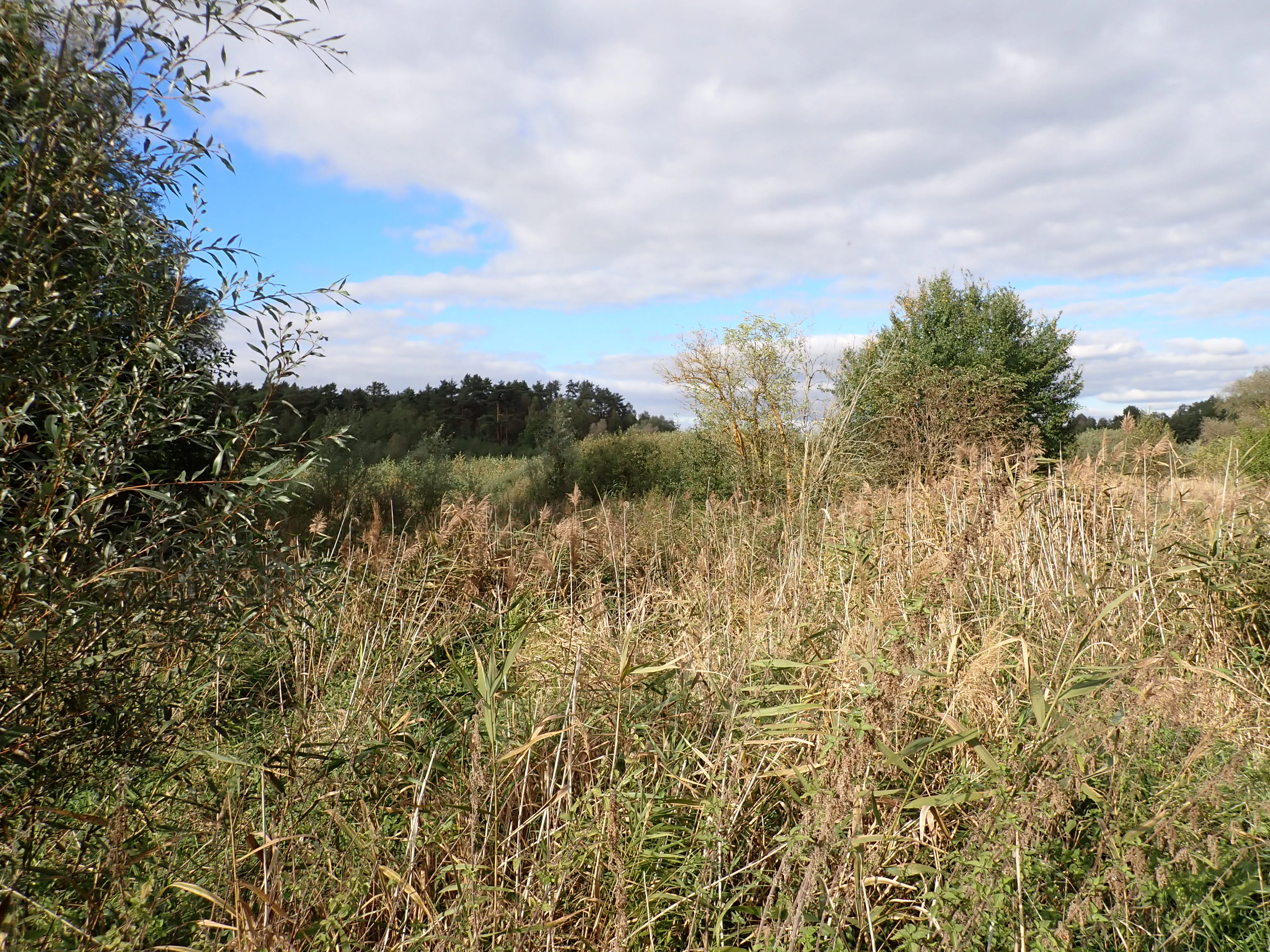
A horizontal landscape view of a marshy area with tall grasses, shrubs, and trees under a partially cloudy blue sky.
A view of the wetland landscape at Mokradła Sułowskie nature reserve.

Mokradła Sułowskie history and protected-area timeline

Mokradła Sułowskie was formally established as a nature reserve by Order No. 366 of the Minister of Environmental Protection, Natural Resources, and Forestry, issued on 26 November 1990. The order took legal effect on 3 January 1991 and designated the wetland complex near Sułów as a protected area under Polish reserve law.

At the time of its original designation, the reserve covered roughly 33.73 hectares. The protected area has since been expanded modestly to its present size of about 45 hectares, though detailed records on the precise boundary changes are limited in the source material. The reserve was originally known under the name Torfowiska Sułowskie, reflecting the prominence of its peatland component, before later being redesignated Mokradła Sułowskie, a name that emphasizes its broader wetland character.

In 2016, a formal conservation plan was adopted for the reserve, confirming that the entire area is now managed under strict protection. Around the same period, the broader ecological significance of the site was recognized through the creation of the Natura 2000 habitat site Torfowiska Sułowskie (PLH080029), whose boundaries broadly overlap with those of the national reserve.

Mokradła Sułowskie landscape and geographic character

The landscape of Mokradła Sułowskie is defined by low-lying, water-saturated terrain shaped by the glacial legacy of the Łagów Lake District. The reserve does not contain dramatic topography; instead, its terrain consists of shallow lake basins, peat-filled depressions, and gently undulating ground where water sits close to or above the surface for much of the year.

The northern section is shaped by an overgrown eutrophic lake, fringed by emergent vegetation that increasingly encroaches on the open water and reduces the effective water surface. The southern section is dominated by a peatland mosaic, with deeply waterlogged soils supporting continuous cover of tall reed vegetation. A small, fully overgrown basin lies at the core of this southern complex, marking a transition point between open water and mature marsh.

Together, these two sections present a compact portrait of the post-glacial wetland landscape typical of western Poland, where water bodies, reeds, and remnants of floodplain forest are interwoven across only a few dozen hectares.

Mokradła Sułowskie ecosystems, habitats, and plant life

Mokradła Sułowskie protects a rich wetland ecological complex that combines several distinct habitat types within a very restricted area. These include the open water and emergent vegetation of a strongly eutrophicated lake, reed-dominated marshes and sedge-rich peatlands, and transitional zones where moist soils give way to wet forest communities such as alder floodplain woodland.

The northern part of the reserve is characterized by over a third of the lake’s surface being covered by emergent aquatic plants, indicating advanced natural lake succession. The southern bog complex is dominated by tall reeds growing on waterlogged peat, with a small fully overgrown basin at its centre. The vegetation pattern reflects classic mid-successional wetland dynamics in a post-glacial landscape, where open water gradually turns into marsh and eventually into wet woodland.

Forest inventory records describe both protected sections as unproductive wasteland, which reflects their dependence on persistent water saturation. The mosaic of habitats supports a varied flora typical of eutrophic water bodies, reeds, sedge mires, and moist forests, making the reserve a representative example of lowland central European wetland ecology even at a small scale.

Mokradła Sułowskie wildlife and species highlights

Although the reserve is small, its mosaic of open water, reeds, peatland, and wet forest habitats supports a notably diverse avifauna. Documentation associated with the reserve records 43 bird species, highlighting its role as a refuge within an otherwise largely cultivated regional landscape.

The combination of emergent vegetation-covered water, reedbeds, and surrounding wet forest provides breeding, feeding, and sheltering conditions for both water-associated and wetland-woodland bird species. The overgrown lake and dense reed zones are particularly relevant for species that depend on marshy conditions, while the surrounding alder and riparian woodlands support woodland bird communities.

The reserve’s value for fauna extends beyond birds; the mosaic of aquatic, bog, and wet forest habitats also sustains the invertebrate and small vertebrate communities typical of Polish lowland wetlands. Within the broader region, the reserve functions as a small but ecologically coherent refuge for wetland-dependent wildlife.

Mokradła Sułowskie conservation status and protection priorities

Mokradła Sułowskie was established to preserve habitats of rare plant and animal species characteristic of aquatic ecosystems, peatlands, and floodplain forest communities, and to maintain the spontaneous natural processes shaping these environments. Its conservation purpose emphasizes the protection of wetland successional stages rather than a single habitat type, recognizing the ecological value of the interactions between open water, reeds, and wet forest.

Under the 2016 conservation plan, the entire reserve is now managed under strict protection, meaning that direct human intervention is minimized to allow natural processes to continue shaping the landscape. This protection status reflects the site’s scientific and natural value and acknowledges the fragility of the eutrophic lake and peatland complex.

The reserve’s significance is reinforced by the parallel designation of the Natura 2000 habitat site Torfowiska Sułowskie (PLH080029), whose boundaries broadly overlap with the national reserve. This dual designation integrates the site into the European Union’s ecological network, giving it both national and continental conservation recognition. Although the reserve is not protected under international law directly, its inclusion in Natura 2000 underlines its importance within the wider framework of European habitat conservation.

Mokradła Sułowskie cultural meaning and human context

The reserve takes its name from the nearby settlement of Sułów, in the historical region of western Poland that has long been characterized by small agricultural communities coexisting with extensive wetlands and forest. The landscape around Rzepin, where the reserve lies, has historically been shaped by forestry and small-scale farming, with the wet, low-lying soils of the area often considered marginal for cultivation and documented in forest inventories as wasteland.

This cultural background helps explain why such compact wetland complexes have survived in the region: the very conditions that limited agricultural use also reduced large-scale drainage and made the sites suitable candidates for nature protection. The reserve thus reflects a broader regional pattern in which ecological value and historical land use have intersected to preserve small but characteristic wetland fragments.

Top sights and standout views in Mokradła Sułowskie

Mokradła Sułowskie stands out as a compact wetland reserve where an overgrown eutrophic lake, dense reedbeds, and waterlogged peatlands coexist within a single protected complex. The division of the site by a regional road into contrasting northern and southern sections gives visitors and researchers a rare opportunity to compare different stages of wetland succession side by side.

Its parallel status as a Natura 2000 habitat site underscores its recognition beyond Poland, while its 2016 strict-protection designation confirms the high value placed on preserving its spontaneous ecological processes. For such a small area, the reserve carries considerable ecological weight in the regional network of protected wetlands.

Best time to visit Mokradła Sułowskie

Like most Polish wetland reserves, Mokradła Sułowskie is best appreciated in the warmer months, when reeds and emergent aquatic vegetation are at their most developed and wetland bird activity is highest. Late spring and early summer are typically the most rewarding periods for observing breeding birds and the full lushness of marsh vegetation.

Autumn can also be a meaningful time, when changing plant communities and migratory waterbirds pass through the area. Winter visits are generally less rewarding for casual observation, as deep snow and frozen surfaces obscure the characteristic wetland textures, though the open, low-lying landscape remains atmospheric. Because the reserve is under strict protection, on-site access is restricted, and most engagement with the site occurs from surrounding paths or through research and documentation.


Monthly climate preview

Long-term monthly temperature averages and precipitation measurements for Mokradła Sułowskie

Mokradła Sułowskie Climate Normals and Measured Temperature Rhythm

Mokradła Sułowskie experiences a measured annual temperature range from subzero winter minima to warm summer maximums alongside consistent daily precipitation records. Examining the complete twelve-month climate profile reveals long-term weather patterns and monthly variations across this protected area.
Annual mean9 °C
-1 °C20 °C
Jan-1°
Feb
Mar
Apr
May14°
Jun18°
Jul20°
Aug20°
Sep15°
Oct
Nov
Dec
Warmest month
July

20 °C

Coolest month
January

-1.3 °C

Wettest month
July

2.5 mm/day

Driest month
April

1.1 mm/day

Park location guide

Geography guide, regional context, and park location map for Mokradła Sułowskie

Mokradła Sułowskie park geography, regions, and map view in Poland

Understand where Mokradła Sułowskie sits in Poland through a broader geographic reading of the surrounding landscape, nearby location context, and its mapped position within the national park landscape.

How Mokradła Sułowskie fits into Poland

Poland, officially the Republic of Poland, is a Central European country spanning from the Baltic Sea in the north to the Carpathian Mountains in the south. It borders Germany, Czech Republic, Slovakia, Ukraine, Belarus, Lithuania, and Kaliningrad Oblast. The country has a temperate climate, diverse landscapes, and is known for its rich history, cultural heritage, and strong economic position within the EU.

Wider geography shaping Mokradła Sułowskie in Poland

Poland occupies 312,696 km2 in Central Europe, extending from the Baltic Sea coast in the north to the Sudetes and Carpathian Mountains in the south. It borders Germany to the west, Czech Republic and Slovakia to the south, Ukraine and Belarus to the east, and Lithuania and Kaliningrad Oblast to the northeast. The landscape includes lowland plains, uplands, and mountain ranges.

Map view of Mokradła Sułowskie

Use this park location map to pinpoint Mokradła Sułowskie in Poland, understand its exact geographic position, and read its mapped placement within the surrounding landscape more clearly.

Pigeon | © OpenStreetMap contributors

Location context for Mokradła Sułowskie

Lubusz Voivodeship

Visualizing peatlands, overgrown lake basins, and wetland habitats across the reserve

Mokradła Sułowskie Photos and Landscape Scenery in Western Poland

Visual documentation captures the unique wetland terrain and post-glacial protected landscapes found within Mokradła Sułowskie. Detailed imagery reveals shallow water basins, dense reedbeds, and rich peat-forming mires across both northern and southern sectors.

A horizontal landscape view of a marshy area with tall grasses, shrubs, and trees under a partially cloudy blue sky.

Park atlas

Compare adjacent wetland habitats, peatlands, and regional nature reserves

Explore Parks Near Mokradła Sułowskie and Related Protected Landscapes

Continue geographic discovery beyond Mokradła Sułowskie by browsing other protected areas sharing similar post-glacial terrain. Comparing adjacent reserves helps reveal broader ecological patterns across the surrounding regional wetland network.
Protected landscapePoland
About 8.3 km away#1 closest

Northwest

Park Krajobrazowy Ujście Warty: Protected Landscape and River Valley Atlas

Mapping wetland ecosystems and floodplain geography in western Poland

Park Krajobrazowy Ujście Warty preserves a significant lowland river valley landscape characterized by vast open pastures, marshes, and rare riparian oak forests. Located primarily within the Lubuskie region, this protected area offers a clear view into the floodplain processes of the Warta river basin, providing a distinct geographic context for wetland conservation and waterbird habitat mapping in Poland.

Area
194.96 km²
Established
1996
Relief
Lowland
Climate
Temperate
Nature reserveBrandenburg
About 12 km away#2 closest

West

Fledermausquartier Brauereikeller Frankfurt (Oder) Nature Reserve and Protected Landscape

Urban bat conservation site in Brandenburg, Germany

The Fledermausquartier Brauereikeller Frankfurt (Oder) encompasses 1.34 hectares of protected land, centered on a historic brewery ruin that has become a vital habitat for hibernating bats. By leveraging specialized microclimates within brick cellars and maintaining a protective green buffer, the reserve functions as a landmark for urban wildlife preservation and transboundary conservation efforts in Brandenburg.

Area
0.013 km²
Established
2006
IUCN
IV
Relief
Lowland
Watercolor painting of a soft landscape featuring a calm, pale-pink reflective lake in the foreground and a layered, muted-green forest and hilly horizon in the background.
Nature reserveBrandenburg
About 15 km away#3 closest

Southwest

Fauler See/Markendorfer Wald: Protected Nature Reserve and Woodland Geography

A forest and lake landscape in Brandenburg, Germany.

Fauler See/Markendorfer Wald functions as a key nature reserve within the outskirts of Frankfurt Oder. This 171 hectare protected area combines the Fauler See lake with the adjacent Markendorfer Wald, creating a dense woodland and wetland refuge. The terrain highlights how small scale lowland sites maintain ecological importance within busy regional transport environments.

Area
1.71 km²
Established
2003
IUCN
IV
A watercolor painting showing a quiet wetland with calm water, scattered dark tree stumps, reeds in the foreground, and rolling green hills in the distance under a pale sky.
Nature reserveBrandenburg
About 16 km away#4 closest

West

Booßener Teichgebiet Nature Reserve: Regional Geography and Protected Landscape Analysis

Glacial meltwater valleys and pond ecosystems in eastern Brandenburg

Discover the geographic footprint of Booßener Teichgebiet, a 104-hectare nature reserve in Brandenburg. This protected area features a unique combination of managed stream corridors, impoundment ponds, and xerothermic biotopes nestled within a glacial meltwater valley near the German-Polish border.

Area
1.04 km²
Established
2008
IUCN
IV
Relief
Lowland
National parkLubusz Voivodeship
About 19 km away#5 closest

North

Park Narodowy „Ujście Warty” National Park: Regional Geography and Wetland Landscapes

A major protected riparian and floodplain zone in western Poland

Located in the Lubusz Voivodeship, Park Narodowy „Ujście Warty” features an extensive network of wetlands, marshes, and meadows at the Warta and Oder confluence. This atlas entry provides essential geographic context for the park's lowland terrain and riverine ecosystems, which are defined by constant shifts in water levels and seasonal flooding patterns that sustain dense bird populations.

Area
80.74 km²
Established
2001
Visitors
52K annual
Relief
Lowland
Watercolor illustration showing a river winding through rolling green hills with sparse vegetation
National parkLubusz Voivodeship
About 19 km away#6 closest

North

Warta Mouth National Park: A National Park Protecting Vital European Wetlands

Explore mapped protected areas and bird habitats in Lubusz Voivodeship.

Warta Mouth National Park, located in Poland's Lubusz Voivodeship, is a significant protected landscape safeguarding the ecologically rich confluence of the Warta and Oder rivers. As the nation's most recently established national park, it provides critical habitat for a vast array of migratory and breeding bird species within its extensive marshlands and floodplains. This park offers a unique opportunity for atlas-driven exploration of Central European wetland geography and the mapped boundaries of a vital conservation area.

Area
80.38 km²
Established
2001
IUCN
II
Visitors
52K annual
Protected areaLubusz Voivodeship
About 20 km away#7 closest

North

Ujście Warty Protected Area: Geography and Landscape Atlas of the Warta River Valley

Natura 2000 wetland and floodplain mapping in Lubusz Voivodeship

Examine the physical geography of Ujście Warty, a major lowland protected area in western Poland. This landscape features a unique layering of river arms, alluvial forests, and dry grasslands, serving as a vital ecological corridor within the broader Oder basin. Use this mapped overview to study the terrain features and structural connectivity of these significant floodplain habitats.

Area
332.15 km²
Water
Water-dominated
Nature reserveLubusz Voivodeship
About 21 km away#8 closest

East

Rezerwat przyrody Dolina Ilanki II: Protected Peatland and River Valley Geography

A vital nature reserve within the Ilanka River corridor

Rezerwat przyrody Dolina Ilanki II represents a key ecological site in the Lubusz Voivodeship. Focused on the conservation of spring-fed mires and alder swamp forests, the reserve forms a critical part of the larger Ilanka valley habitat network. Discover the terrain characteristics and mapped extent of this protected lowland wetland.

Area
0.113 km²
Established
2017
Relief
Lowland
Scope
Terrestrial

Common questions about visiting, size, designation, and location context for Mokradła Sułowskie

Mokradła Sułowskie FAQs for park facts, access, geography, and protected area context

Find quick answers about Mokradła Sułowskie, including protected-area facts, park geography, trail and visitor context, and how the park fits into its surrounding country and regional landscape.
MoriAtlas Explorer

Continue Your Protected Areas Search Across the Global Atlas

Deepen your exploration by continuing the structured search for national parks and protected areas worldwide. Utilize the comprehensive filtering capabilities to compare different conservation landscapes and refine your understanding of global park geography. Discover more about the distribution and characteristics of protected natural areas.

Global natural geography