
Mori Atlas logo
Nature reserveMonheimer Baggersee

Understanding the mapped boundaries and unique ecological terrain of this urban-adjacent gravel pit reserve

Monheimer Baggersee Nature Reserve: A Detailed Geographic Atlas of a Lower Rhine Protected Landscape

(Naturschutzgebiet Monheimer Baggersee)

Monheimer Baggersee encompasses a 71-hectare nature reserve within the Lower Rhine terrace, offering a distinct study in floodplain ecological succession and mineral-rich habitats. The site features a large mesotrophic groundwater lake, exposed gravel bars, and sand flats that function as a vital regional corridor for rare waterbirds and aquatic flora. Through this detailed atlas record, users can analyze the park's internal topography, including its shoreline dynamics and the sheltered peninsula woodlands that define this significant Nordrhein-Westfalen protected landscape.

gravel pit lakewaterbird reservecormorant colonyLower Rhinegravel bankspioneer habitats
Digital illustration of a mountainous landscape with a multi-tiered waterfall, surrounding forests, and berry bushes in the foreground under a sunny sky.

Monheimer Baggersee

Nature reserve

Park overview

Structured park overview, official facts, and landscape profile for Monheimer Baggersee

Monheimer Baggersee park facts, protected area profile, and essential visitor context

Review the core facts for Monheimer Baggersee, including designation, size, terrain, visitor scale, habitats, and operating context in one park-focused overview.

About Monheimer Baggersee

Monheimer Baggersee lies on the Lower Rhine terrace east of the town core of Monheim am Rhein, framed on one side by the A59 motorway and on the other by a mosaic of woodland, scrub, and former industrial land. Although tightly enclosed by fences and dense vegetation that limit public access, the reserve offers a substantial patch of near-natural habitat in a heavily urbanized part of North Rhine-Westphalia, just south of Düsseldorf and Leverkusen.

The landscape originated as a wet gravel quarry. Extraction ceased in 1998, leaving behind a mesotrophic groundwater lake fed by the regional water table. The northern and eastern parts of the lake are shaped by shallow water and several coarse gravel banks, gradually enclosing a central island that is often partly flooded. To the northwest, the Büteführ peninsula, wooded with poplars and white willows, frames the lake and supports a large cormorant breeding colony.

The southwestern shore is marked by tall, steep banks that provide nesting sites for sand martins and shelter for associated species. Sandy and gravelly flats around the shoreline function as pioneer habitat, hosting specialist plants, invertebrates, and reptiles. The reserve has been recognized as a refuge of state-level importance for several groups: wintering waterbirds because the lake freezes late even in cold winters, waterbirds using it as a staging and molting site, and rare aquatic plants because the open, nutrient-poor conditions mimic former natural floodplain waters.

Quick facts and research context for Monheimer Baggersee

Monheimer Baggersee is a nature reserve (Naturschutzgebiet) of about 71 hectares in Monheim am Rhein, in the Mettmann district of North Rhine-Westphalia, lying on the Lower Rhine terrace east of the town center near the A59 motorway. The protected area was established in 1981 and updated in the 2012 landscape plan, classified under IUCN Category IV as a habitat and species management area, and administered by the lower nature conservation authority of the Mettmann district under designation ME-004.

The core of the reserve is a former wet gravel quarry, abandoned in 1998, that has evolved into a mesotrophic groundwater lake with shallow water zones, coarse gravel banks, sand flats, and steep southwestern banks. It is recognized for its state-level importance for waterbirds and for rare aquatic flora, including species once thought extinct in the Lower Rhine region.

Protection and recognition

Examine documented terrestrial boundary records and administrative designation details.

Monheimer Baggersee Protection Status and International Recognition Data

Monheimer Baggersee maintains a documented terrestrial protection scope within global conservation registries. Official records track administrative status and geographic parameters without external international designations.

Protection details

Protection scope
Terrestrial
Transboundary protection
No
WDPA ID
164659
Park context

Deeper park guide and search-rich context for Monheimer Baggersee

Monheimer Baggersee history, landscape, wildlife, and travel context

Explore Monheimer Baggersee through its history, landscape character, ecosystems, wildlife, conservation priorities, cultural context, and seasonal travel timing in a structured park guide built for atlas discovery and search intent.

Why Monheimer Baggersee stands out

Monheimer Baggersee is best known as a bird-focused gravel pit reserve, with state-level significance for wintering, migrating, and breeding waterbirds and waders. Its cormorant colony, with around one hundred breeding pairs, ranks among the largest in North Rhine-Westphalia, and the site also supports little ringed plovers, common sandpipers, and a range of ducks including teal, garganey, and mergansers. Equally distinctive is the reserve's role as a refuge for rare aquatic plants and pioneer species. The nutrient-poor groundwater lake hosts submerged species, several on the North Rhine-Westphalian Red List, and at least two that were presumed extinct in the Lower Rhine Basin. The combination of open water, gravel bars, sandy shoreline, and newly created woodland gives the site a layered ecological character that is uncommon in such an urban-adjacent setting.
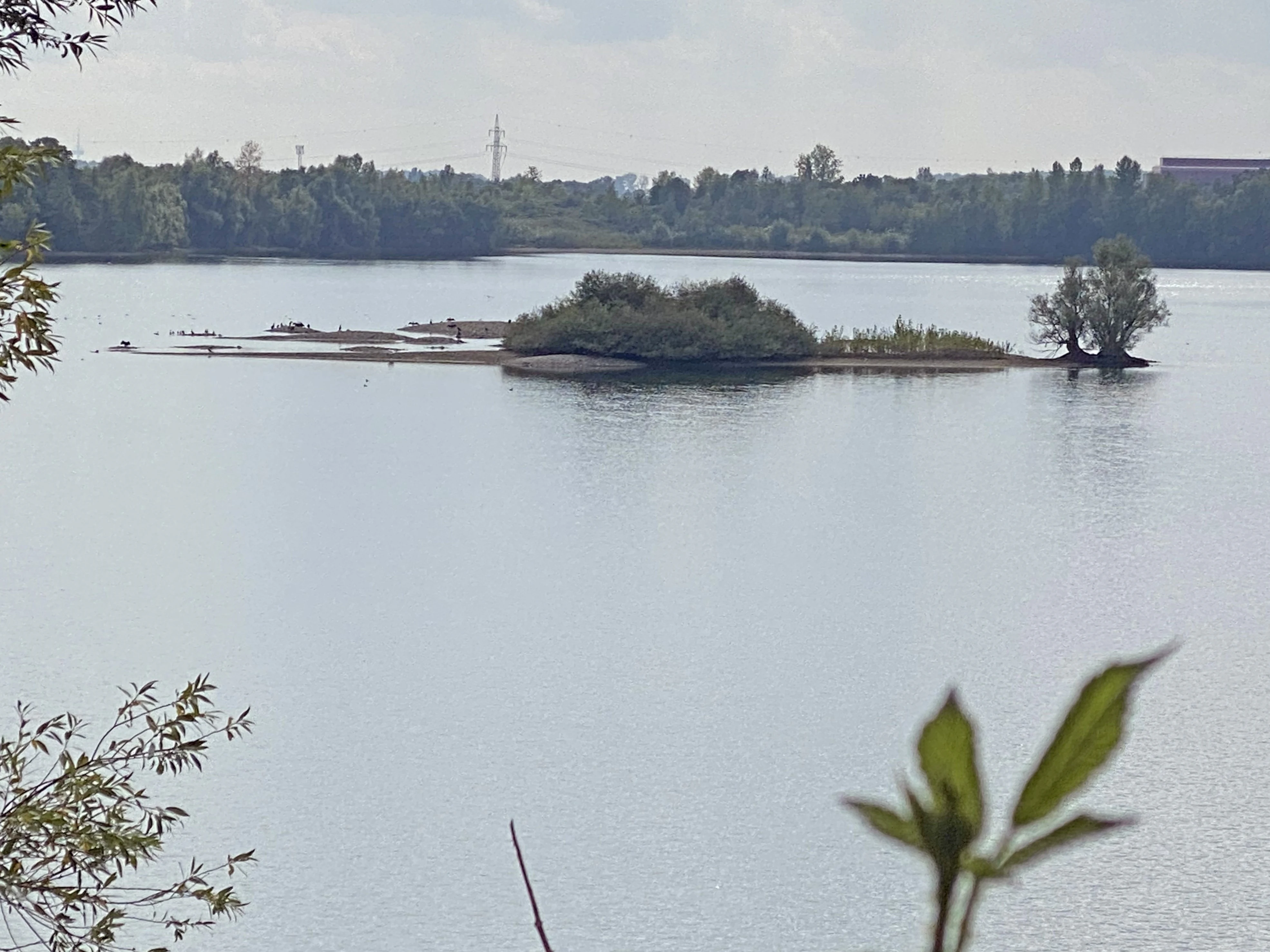
A calm lake featuring a small, vegetated island in the center, viewed from a slightly elevated position with blurred foliage in the foreground.
A view of the bird island in the Monheimer Baggersee nature reserve.

Monheimer Baggersee history and protected-area timeline

The Monheimer Baggersee site has its origin in industrial gravel extraction on the Lower Rhine terrace. Wet quarrying disturbed the original floodplain deposits and produced a chain of artificial waterbodies along the Rhine; the main lake in what is now the reserve was worked until 1998, when operations ended.

Recognition of the biological value of the abandoned workings led to formal protection in 1981, when the area was designated a nature reserve under the reference code ME-004. The protection regime was subsequently incorporated into the landscape plan for the Mettmann district, with an updated version adopted in 2012 that reaffirmed the site as a habitat and species management area under IUCN Category IV.

Since designation, the reserve has been managed by the lower nature conservation authority of the Mettmann district, with restricted public access enforced by perimeter fencing and dense shore vegetation. Despite this, the city of Monheim has allowed local angling and sailing clubs limited recreational use of the lake under specific conditions, balancing conservation goals with traditional local use.

Monheimer Baggersee landscape and geographic character

The Monheimer Baggersee reserve sits on the flat Lower Rhine terrace, a former floodplain landscape shaped by Pleistocene and Holocene Rhine deposits. Elevations in the area lie between roughly 34 and 40 meters above sea level. The setting is defined by a mosaic of water, raw mineral ground, and young woodland rather than by dramatic relief, but within those flat surroundings the lake and its shoreline offer a varied and ecologically rich terrain.

The lake itself is irregular in plan, with shallow, gradually shelving margins in the northeast and steeper banks in the south and southwest. Several coarse gravel banks break the surface near the central island, and finer sand and gravel flats rim much of the shore. The Büteführ peninsula, a wooded arm of land in the northwest, gives the basin a more enclosed feel and provides elevated, sheltered ground that contrasts with the open water.

Around the water, the landscape includes patches of dense shoreline shrubby vegetation and managed woodland edges, deliberately maintained to limit visual access and disturbance to the wildlife. The result is a deliberately quiet, inward-looking landscape whose character is shaped as much by what is hidden from view as by what is directly visible.
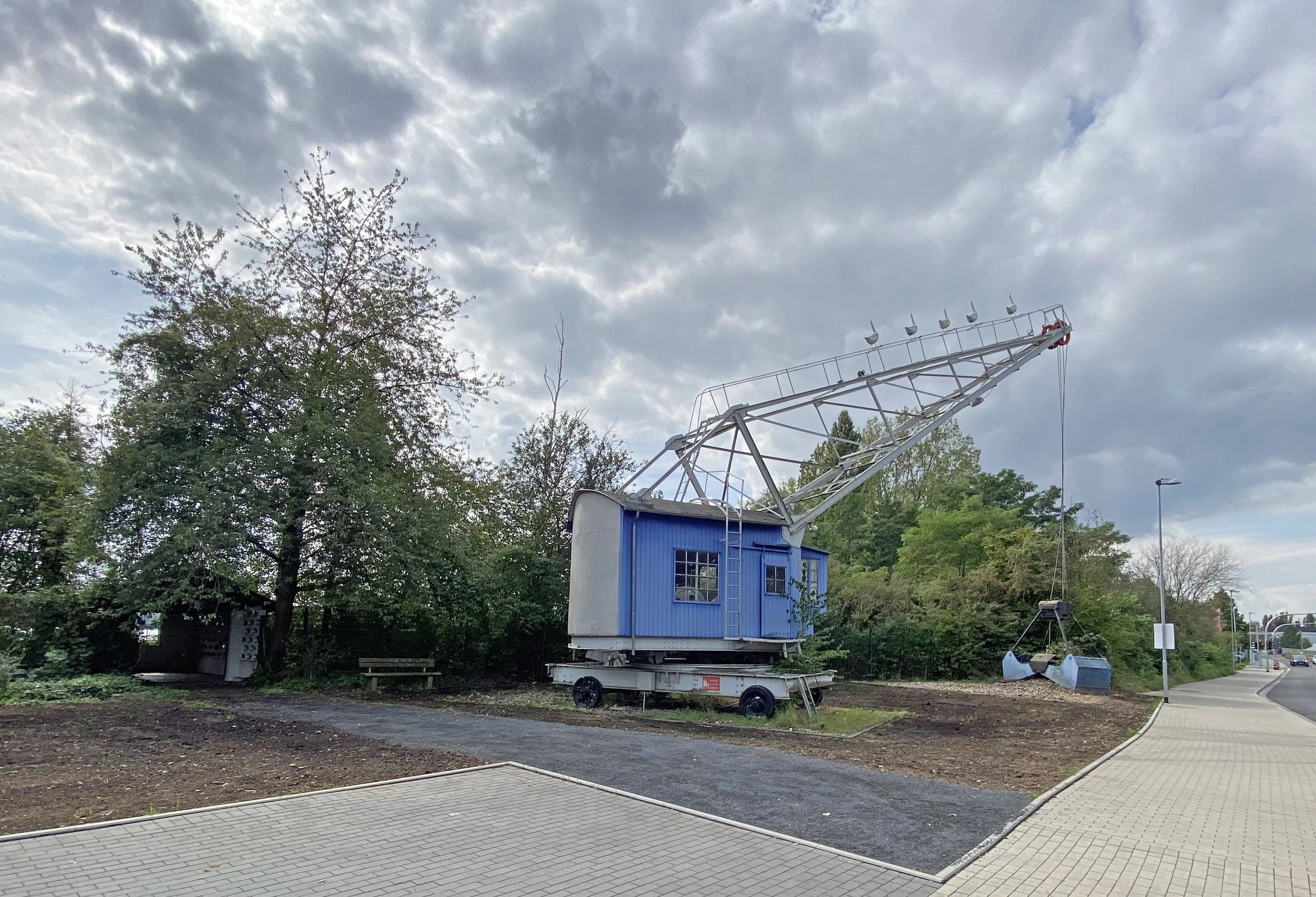
A vintage blue and white industrial gravel crane standing on wheels on the edge of a paved path in a green area under a cloudy sky.
A vintage industrial gravel excavator preserved at the Monheimer Baggersee nature reserve.

Monheimer Baggersee ecosystems, habitats, and plant life

Ecologically, the Monheimer Baggersee reserve is a textbook example of a secondary biotope complex built on the raw substrates left behind by gravel extraction. The nutrient-poor, groundwater-fed lake is classified as mesotrophic, a status that on its own is increasingly rare in the heavily modified Lower Rhine floodplain, and that supports a particular community of submerged aquatic plants sensitive to enrichment.

Eight species of aquatic plants have been documented in the lake, of which five appear on the North Rhine-Westphalian Red List of threatened species. Two of the submerged species recorded, including the rigid hornwort-like pondweed Stuckenia nodosa and the fan-leaved water buttercup Ranunculus circinatus, had previously been considered extinct in the Lower Rhine Basin, making their rediscovery here a notable conservation event.

The shoreline forms a parallel set of pioneer habitats. Coarse gravel banks provide substrate for specialized invertebrates and important resting and nesting habitat for birds, while sandy flats at the southern end support warm-loving insects and reptiles. The Büteführ peninsula and other vegetated margins create a transition from open pioneer ground to scrub and young poplar, willow, and mixed woodland, giving the site a full gradient of early-succession habitats in a compact area.
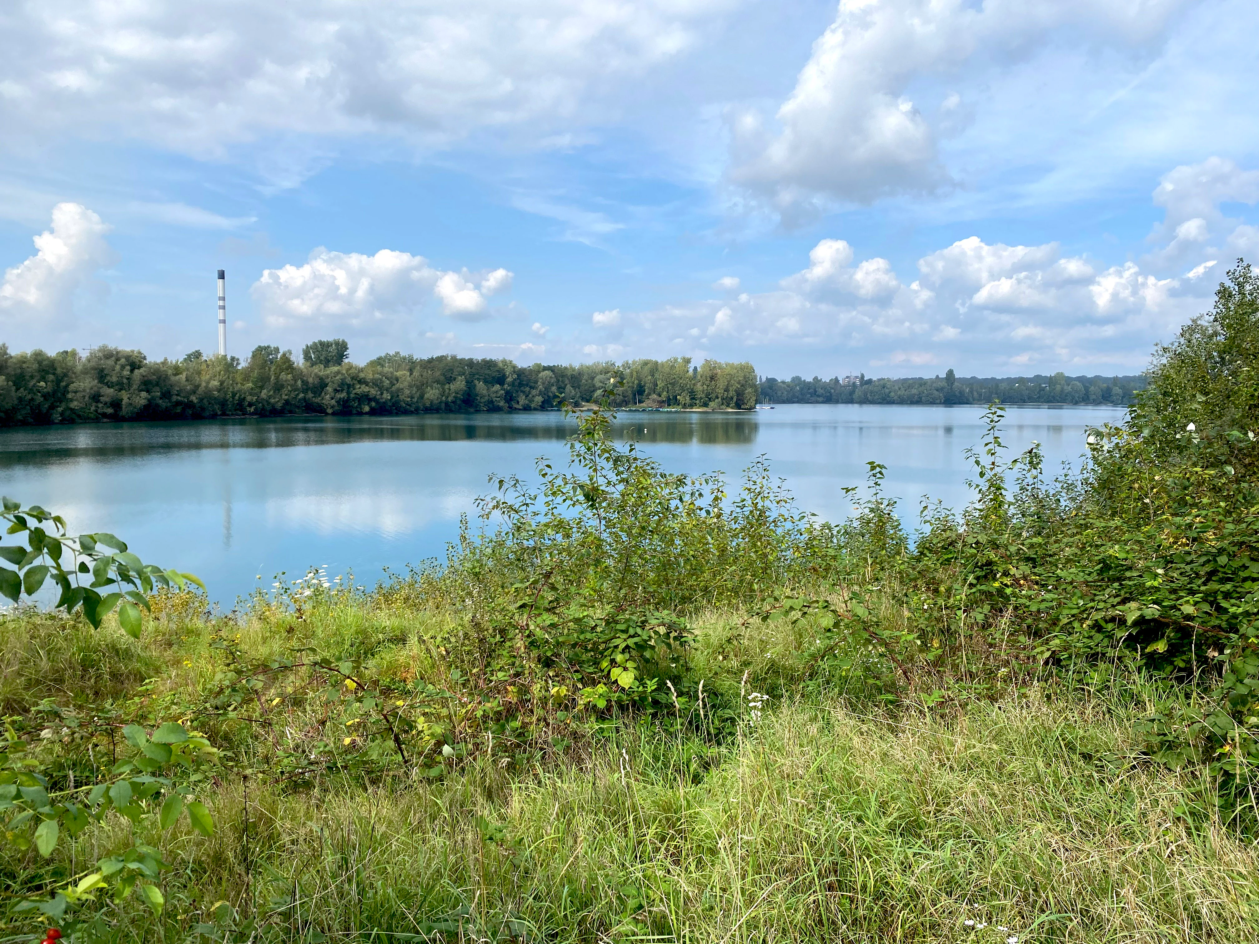
A peaceful, wide view of a calm lake under a partly cloudy sky, with tall grasses and shrubs in the foreground and a distant treeline.
A view across Monheimer Baggersee, showing the lake surrounded by dense vegetation.

Monheimer Baggersee wildlife and species highlights

The Monheimer Baggersee reserve is best understood through its birdlife. It is recognized at the state level as a wintering, staging, breeding, and molting site for waterbirds and waders, with particular value because the relatively sheltered groundwater lake tends to freeze only late into cold winters, providing reliable open water when other waters are unavailable.

The cormorant breeding colony on the Büteführ peninsula is one of the focal features of the site, comprising roughly one hundred breeding pairs; this makes it the fourth largest cormorant colony in North Rhine-Westphalia and a regionally important concentration of the species. Around the margins, species such as the little ringed plover, common sandpiper, and various ducks including common goldeneye, garganey, Eurasian teal, northern shoveler, and several species of merganser use the gravel banks and shallow water, some of them as breeding or staging birds and others as seasonal visitors.

Mammals and herptiles benefit from the mosaic of habitats as well. The sand lizard, a threatened reptile in the region, occupies the sandy flats at the southern end of the lake, while the rare Nathusius' pipistrelle bat is suspected to maintain a mating territory in the area. The dry, warm, sand-dominated southern shore also supports the blue-winged locust, a heat-loving grasshopper that is strongly threatened in North Rhine-Westphalia and that depends on exactly the kind of early-succession sandy habitat which the abandoned quarry provides.
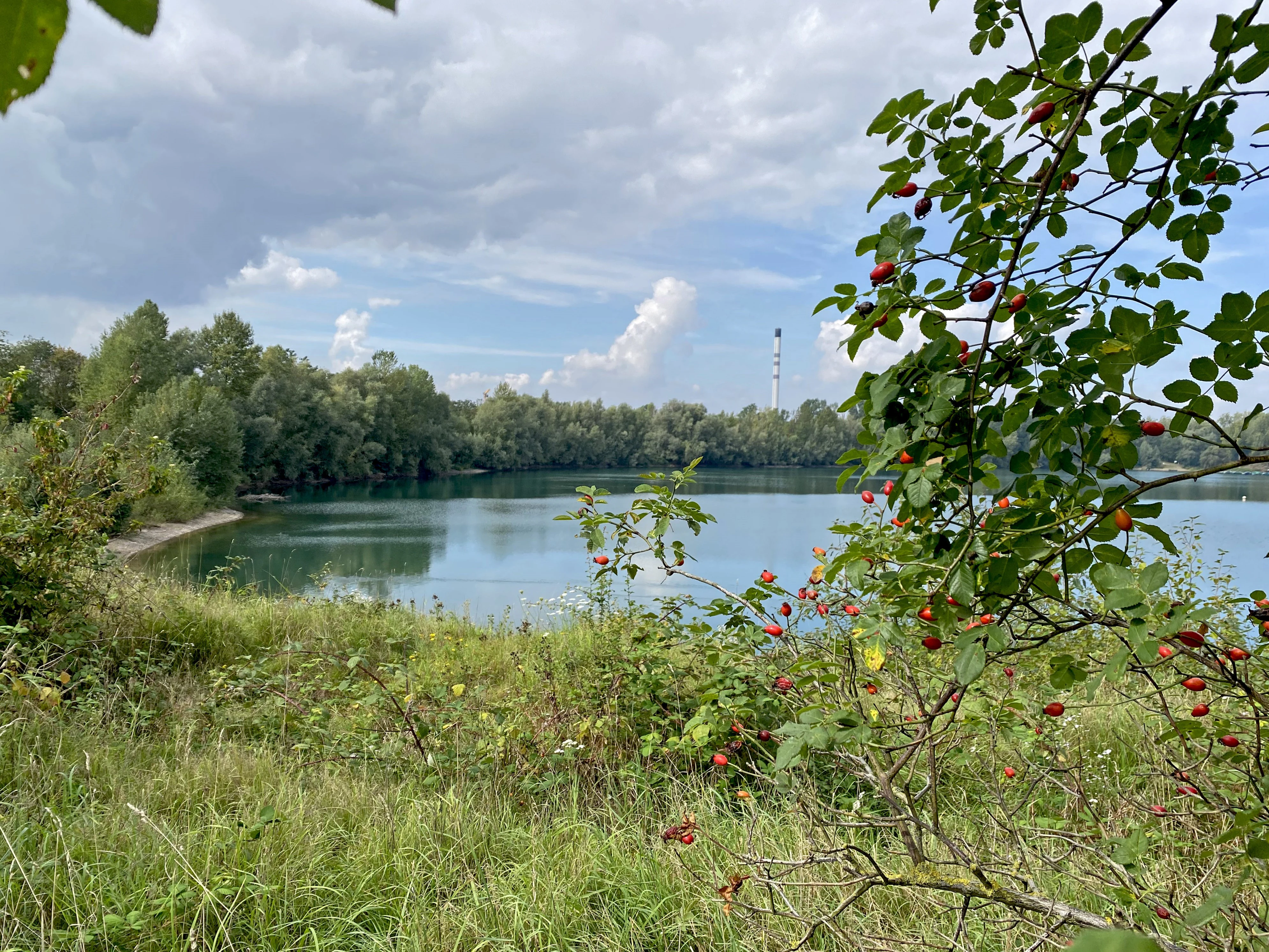
A calm lake viewed through leafy branches with small red berries in the foreground, with dense woods lining the far shore under a cloudy sky.
A view of the southern shore of Monheimer Baggersee, featuring native flora in the foreground.

Monheimer Baggersee conservation status and protection priorities

The conservation significance of Monheimer Baggersee lies in the way a single site combines a mesotrophic groundwater lake with an unusually rich set of pioneer habitats on raw mineral substrate. The reserve is officially classified as IUCN Category IV, a habitat and species management area, with two clearly stated protection goals: the maintenance of the lake and its structured shoreline as a refuge for waterbirds and for aquatic plant species tied to nutrient-poor standing waters, and the preservation of the broader secondary biotope complex that supports pioneer communities in aquatic, amphibious, and terrestrial transitions.

The site is significant at the state level in North Rhine-Westphalia for the diversity of functions it serves for waterbirds: wintering, migration staging, breeding, and molting. Its late-freezing lake gives it a particular role as a winter refuge. The endangered and locally extinct aquatic plant species found here have turned an abandoned industrial site into a de facto ark for flora that has largely disappeared from the surrounding floodplain.

Management is undertaken by the lower nature conservation authority of the Mettmann district. Perimeter fencing and dense shoreline vegetation are used to keep public access minimal, recognizing that the reserve's value depends on low disturbance levels, while limited recreational use by local angling and sailing clubs is tolerated under specific conditions to maintain a long-standing relationship with the local community.

Monheimer Baggersee cultural meaning and human context

Monheimer Baggersee sits in a part of the Lower Rhine that has been shaped for centuries by gravel and aggregate extraction tied to the river's sediment deposits, and by the agricultural and settlement patterns of the historic Rhine floodplain. While the reserve itself is a product of industrial extraction rather than of pre-industrial land use, the broader cultural context of the area is one where the Rhine has long been both a livelihood and a boundary, and where reclaimed quarry sites have come to be valued in their own right as ecological refuges.

The local community retains ties to the lake through recreational clubs for angling and sailing, whose access reflects a long tradition of using the Rhine and its associated waters for leisure. Today the dominant human interaction with the site is one of deliberate restraint: fences, screening vegetation, and limited access are used to keep the lake a quiet refuge, while the city of Monheim balances this with structured use by organized local groups.

Top sights and standout views in Monheimer Baggersee

Monheimer Baggersee combines a relict floodplain-style lake with raw mineral pioneer habitats in a compact, urban-adjacent reserve. The cormorant colony on the Büteführ peninsula, with its roughly hundred breeding pairs, ranks among the largest in North Rhine-Westphalia, while the surrounding gravel banks and shallow water support a long list of threatened waders and ducks in a single small area.

Equally notable is the lake's role for aquatic plants. Eight submerged species have been documented, including red-list species and at least two thought extinct in the Lower Rhine Basin, making the reserve an unexpected anchor for flora that has otherwise vanished from the regional floodplain. Together with species like the sand lizard, the blue-winged locust, and the suspected Nathusius' pipistrelle roost, the site captures a remarkable cross-section of rare Lower Rhine wildlife.

Best time to visit Monheimer Baggersee

As a strictly protected reserve with no general public access, Monheimer Baggersee is not a site for casual walks. For those with an ornithological or ecological interest, the most rewarding periods tend to be the cooler months, when the late-freezing lake reliably attracts wintering waterfowl and migration staging species, and the breeding season, when the cormorant colony on the Büteführ peninsula and the little ringed plovers and common sandpipers on the gravel banks are at their most visible. Spring and autumn passages add a wider variety of waders and ducks, while the waterbird community typically thins in mid-summer as the lake becomes less attractive for staging birds.

Monthly climate preview

Track representative annual temperature ranges and precipitation patterns across the year

Monheimer Baggersee Climate Normals and Long Term Weather by Month

Long term climate data for Monheimer Baggersee records average monthly temperatures ranging from sub-freezing winter lows to warm summer maximums alongside consistent daily precipitation. Examining the complete twelve month profile reveals the full scope of recorded temperature bounds and seasonal moisture shifts across the coordinate point.
Annual mean10 °C
1 °C19 °C
Jan
Feb
Mar
Apr
May13°
Jun17°
Jul19°
Aug19°
Sep15°
Oct10°
Nov
Dec
Warmest month
July

19.2 °C

Coolest month
January

1.3 °C

Wettest month
December

2.6 mm/day

Driest month
April

1.6 mm/day

Park location guide

Geography guide, regional context, and park location map for Monheimer Baggersee

Monheimer Baggersee park geography, regions, and map view in Germany

Understand where Monheimer Baggersee sits in Germany through a broader geographic reading of the surrounding landscape, nearby location context, and its mapped position within the national park landscape.

How Monheimer Baggersee fits into Germany

Germany is a federal republic in Western and Central Europe with a population of over 83 million across sixteen constituent states. It is Europe's largest economy by nominal GDP and a major global exporter and importer. The capital is Berlin, and the country borders Denmark, Poland, Czech Republic, Austria, Switzerland, France, Luxembourg, Belgium, and the Netherlands.

Wider geography shaping Monheimer Baggersee in Germany

Germany is located in Western and Central Europe, spanning 357,022 km². It borders Denmark to the north, Poland and the Czech Republic to the east, Austria and Switzerland to the south, and France, Luxembourg, Belgium, and the Netherlands to the west. The country has coastlines on the Baltic Sea and North Sea to the north, with the Alps located in the southern region.

Map view of Monheimer Baggersee

Use this park location map to pinpoint Monheimer Baggersee in Germany, understand its exact geographic position, and read its mapped placement within the surrounding landscape more clearly.

Pigeon | © OpenStreetMap contributors

Location context for Monheimer Baggersee

Nordrhein-Westfalen

Visual reference for gravel pit habitats, waterbird colonies, and Lower Rhine terrace terrain

Monheimer Baggersee Photos and Landscape Scenery in North Rhine Westphalia

Monheimer Baggersee photos reveal an unusual mosaic of groundwater lakes, raw mineral gravel banks, and willow woodland along the Lower Rhine terrace. Examining protected area imagery clarifies the ecological character of urban adjacent habitats and regional waterbird refuges.

A calm lake featuring a small, vegetated island in the center, viewed from a slightly elevated position with blurred foliage in the foreground.

A calm lake viewed through lush green foliage from an elevated vantage point, with a small island visible in the center under a cloudy sky.

A vintage blue and white industrial gravel crane standing on wheels on the edge of a paved path in a green area under a cloudy sky.

A peaceful, wide view of a calm lake under a partly cloudy sky, with tall grasses and shrubs in the foreground and a distant treeline.

A calm lake viewed through leafy branches with small red berries in the foreground, with dense woods lining the far shore under a cloudy sky.

A calm lake surrounded by trees under a blue sky, with a tall industrial chimney visible in the distance and rose hip bushes in the foreground.

Park atlas

Discover other protected areas and wetland habitats across the Lower Rhine terrace

Parks Near Monheimer Baggersee and Regional Protected Landscape Comparison

Browse nearby nature reserves and regional wetland habitats that share ecological traits with Monheimer Baggersee. Comparing these surrounding conservation areas provides broader geographic context for the Lower Rhine floodplain landscape.
Nature reserveLeverkusen
About 1.8 km away#1 closest

Southeast

Krapuhlsee Nature Reserve: Protected Wetland and Gravel Lake Geography in Leverkusen

Exploring post-industrial habitat mosaics and conservation terrain

Krapuhlsee is a protected nature reserve in Leverkusen, North Rhine-Westphalia, known for its unique concentration of post-mining gravel lakes and nutrient-poor grassland habitats. Managed to support rare wild bee populations and ground-nesting birds, the reserve acts as a critical stepping-stone for ecological connectivity across the heavily industrialized Rhine corridor.

Area
0.082 km²
Established
1986
IUCN
IV
Relief
Lowland
Nature reserveNorth Rhine-Westphalia
About 4.4 km away#2 closest

Southwest

Worringer Bruch Nature Reserve: A Relict Rhine Floodplain in North Rhine-Westphalia

Ancient oxbow meander and vital inner-city wetland landscape.

Worringer Bruch stands as one of the best-preserved, silted-up oxbow meanders along the Lower Rhine. Spanning roughly 164 hectares, this nature reserve integrates floodplain forests, traditional orchards, and marshy meadows into a cohesive wetland mosaic. Serving as a low-lying ecological refuge near Cologne, the area remains deeply connected to the groundwater dynamics of the historic Rhine river corridor.

Area
1.64 km²
Established
1991
Relief
Lowland
Climate
Temperate
Watercolor painting of a pastoral landscape featuring a winding river, green fields, and clusters of trees, rendered in a soft, impressionistic style on a white background.
Nature reserveNordrhein-Westfalen
About 5.5 km away#3 closest

East

Southerberg Nature Reserve: Protected Woodland and Wetland Mosaic in Nordrhein-Westfalen

A rare habitat bridge on the Bergische Sand terrace.

Southerberg serves as a crucial nature reserve in Leverkusen, Nordrhein-Westfalen, balancing wet birch-oak forests with reedbeds and meadows. This compact protected area functions as a key ecological connector between larger regional habitats, showcasing a refined topographic transition from valley basin to sandy slope.

Area
0.149 km²
Established
1987
IUCN
IV
Relief
Lowland
Nature reserveNordrhein-Westfalen
About 5.6 km away#4 closest

Southeast

Wupperinsel Nature Reserve: Mapped Protected Landscapes in Nordrhein-Westfalen

Riparian woodland, floodplain islands, and meadow habitats.

Discover the geographic role of Wupperinsel as a designated nature reserve within the Wupper River corridor. This site features a rare Glatthafer meadow, mature poplar lines, and mixed-woodland groves that provide essential habitat connectivity. Analyze the protected island boundaries and the layered floodplain terrain that characterize this significant ecological fragment in urban Germany.

Area
0.054 km²
Established
1987
IUCN
IV
Nature reserveNordrhein-Westfalen
About 7.9 km away#5 closest

East

Wupperhang mit Henkensiepen und Hüscheider Bachtal Protected Area and Geographic Atlas

Forested river valleys and slopes in Nordrhein-Westfalen

Investigate the detailed geography of Wupperhang mit Henkensiepen und Hüscheider Bachtal, a nature reserve showcasing prime Hainsimsen beech forest and riparian habitats. The area represents a key ecological corridor along the Wupper River, featuring rugged side valleys, calcareous springs, and diverse floodplain vegetation that defines this protected woodland segment of the Bergisches Land.

Area
34.65 km²
Established
1985
IUCN
IV
Watercolor painting of a tranquil, marshy landscape with soft green trees, grass, and a winding path, rendered in a pale, minimalist style.
Nature reserveNordrhein-Westfalen
About 8.1 km away#6 closest

Northeast

Krüdersheide und Götsche Nature Reserve: Geographic Mapping and Protected Land Data

Wetland mosaic and bog forest habitats in Nordrhein-Westfalen

Located in Solingen, the Krüdersheide und Götsche nature reserve protects essential bog woodland, peat cushions, and stream habitats on the Bergische Heideterrasse. This 55-hectare site serves as an important ecological corridor for moisture-dependent flora and fauna within an urbanized region of Nordrhein-Westfalen. Study its mapped boundaries and terrain context through our specialized atlas database.

Area
0.547 km²
Established
2005
IUCN
IV
Relief
Lowland
A horizontal watercolor painting depicting a gentle, hazy green landscape with rolling hills, a line of trees, and a foreground meadow.
Protected landscapeNorth Rhine-Westphalia
About 8.1 km away#7 closest

South

Naturpark Rheinland: Geography and Protected Area Overview in North Rhine-Westphalia

A complex metropolitan nature park and lake district

Naturpark Rheinland represents a distinct convergence of reclaimed lignite mining landscapes, quiet lowland forests, and floodplain wetlands. Its mapped boundaries reveal a diverse terrain of ridges and river valleys that define the environmental character of the Cologne-Bonn metropolitan region.

Area
1,045 km²
Established
1959
Relief
Upland
Climate
Temperate
A minimalist watercolor painting showing stylized green trees and rolling hills against a pale, soft-colored background.
Nature reserveNordrhein-Westfalen
About 8.4 km away#8 closest

Northwest

Schlosspark Benrath Nature Reserve in Nordrhein-Westfalen: A Geographic and Landscape Atlas

Examining historic baroque design and floodplain woodland ecosystems.

Schlosspark Benrath encompasses a vital protected area where rococo architectural layout meets ecologically diverse floodplain forest. Known for its star-shaped linden avenues, ancient yew understory, and significant deadwood habitats, this reserve functions as a crucial green corridor within the lower Rhine terrace, supporting a wide range of bird species and rare beetles.

Area
0.443 km²
Established
2016
IUCN
IV
Relief
Lowland

Common questions about visiting, size, designation, and location context for Monheimer Baggersee

Monheimer Baggersee FAQs for park facts, access, geography, and protected area context

Find quick answers about Monheimer Baggersee, including protected-area facts, park geography, trail and visitor context, and how the park fits into its surrounding country and regional landscape.
MoriAtlas Explorer

Continue Your Protected Areas Search Across the Global Atlas

Deepen your exploration by continuing the structured search for national parks and protected areas worldwide. Utilize the comprehensive filtering capabilities to compare different conservation landscapes and refine your understanding of global park geography. Discover more about the distribution and characteristics of protected natural areas.

Global natural geography