
Mori Atlas logo
Biosphere reserveMono Transboundary Biosphere Reserve

Understanding the mapped boundaries and natural terrain of this unique transboundary protected area

Mono Transboundary Biosphere Reserve: A Geographic Atlas of Coastal Wetlands and Savanna Landscapes

(Réserve de biosphère transfrontière du Mono)

The Mono Transboundary Biosphere Reserve represents a major protected landscape spanning the boundary between Benin and Togo. This expanse covers a complex network of coastal lagoons, mangrove wetlands, and floodplains where the Mono River meets the Atlantic Ocean. Inland, the protected terrain shifts into extensive savanna formations and sacred forest patches, creating a layered environment that integrates diverse ecological zones into a single shared geographic system.

transboundary reserveUNESCO biosphere reserveriver deltamangrovescoastal lagoonwetlands
A stylized vector illustration of a tropical coastal scene featuring a winding river, palm trees, a sandy beach, and calm waters under a soft sky.

Mono Transboundary Biosphere Reserve

Biosphere reserve

Park overview

Structured park overview, official facts, and landscape profile for Mono Transboundary Biosphere Reserve

Mono Transboundary Biosphere Reserve park facts, protected area profile, and essential visitor context

Review the core facts for Mono Transboundary Biosphere Reserve, including designation, size, terrain, visitor scale, habitats, and operating context in one park-focused overview.

About Mono Transboundary Biosphere Reserve

The Mono Transboundary Biosphere Reserve represents a coordinated effort by Benin and Togo to protect a shared landscape shaped by the Mono river and its delta. At its core lies the lower Mono river valley, where channels, islands, floodplains and lagoons create a richly varied mosaic of aquatic and terrestrial environments. The reserve was added to UNESCO's World Network of Biosphere Reserves in 2017, reflecting international recognition of the area's ecological value and its importance for transboundary cooperation.

The protected zone stretches outward from the river mouth to incorporate savanna, forest fragments and traditional community lands. Mangroves form a defining feature of the coastal interface, while inland sections transition into open savanna and patches of sacred forest that hold cultural significance for local communities. This landscape diversity means the reserve is not a single ecosystem but a layered system where freshwater, brackish and marine influences meet dryland habitats.

A defining characteristic of the reserve is its scale relative to the human populations it encompasses. Nearly two million people live within or adjacent to the reserve, relying on a combination of small-scale agriculture including oil palm and coconut cultivation, pastoral grazing, forestry and fishing. The biosphere reserve framework is intended to reconcile these land uses with long-term conservation of the area's natural systems.

Quick facts and research context for Mono Transboundary Biosphere Reserve

The Mono Transboundary Biosphere Reserve is a UNESCO biosphere reserve inscribed in 2017 and centered on the mouth of the Mono river along the Benin-Togo frontier. It covers approximately 346,285 hectares spanning both countries. Its ecosystems combine mangroves, lagoons, floodplains, savanna and fragments of sacred forest. Management is split between Benin's environment ministry (through CENAGREF) and Togo's Ministry of Environment and Forest Resources (through the Direction des Ressources forestières).

Protection and recognition

Examine official protected area records and transboundary conservation status.

Mono Transboundary Biosphere Reserve Protection Status and Governance Data

Mono Transboundary Biosphere Reserve maintains a mixed protection scope governed by international conservation frameworks and cross-border agreements. Structured records detail the official designation history, management scope, and verified administrative boundaries for this transboundary protected area.

Protection details

Protection scope
Mixed
Transboundary protection
Yes
WDPA ID
555703408
Park context

Deeper park guide and search-rich context for Mono Transboundary Biosphere Reserve

Mono Transboundary Biosphere Reserve history, landscape, wildlife, and travel context

Explore Mono Transboundary Biosphere Reserve through its history, landscape character, ecosystems, wildlife, conservation priorities, cultural context, and seasonal travel timing in a structured park guide built for atlas discovery and search intent.

Why Mono Transboundary Biosphere Reserve stands out

The reserve is best known for its large transboundary delta system, where the Mono river, coastal lagoons, mangrove wetlands and sandy shoreline converge. It stands out as one of West Africa's prominent cross-border conservation efforts, recognized by UNESCO for its integration of coastal wetlands, savanna landscapes and human communities dependent on natural resources.
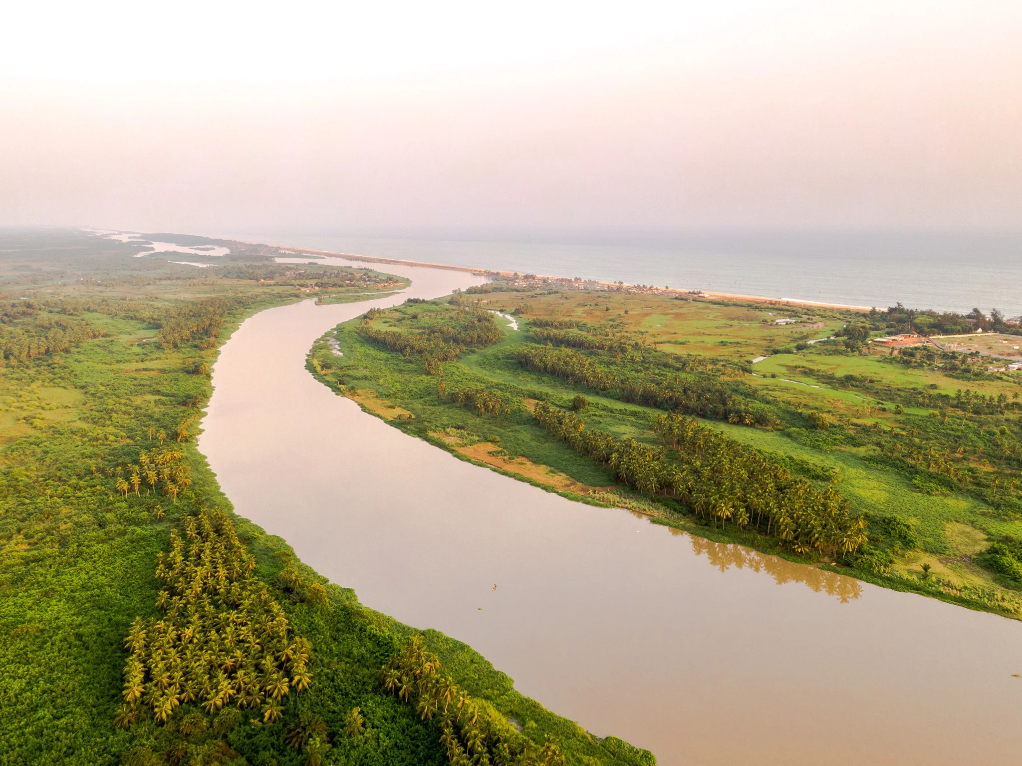
Aerial perspective looking over the wide, calm Mono River, flanked by dense green vegetation and palm trees, leading toward the distant horizon where the river meets the coastline.
Aerial view of the Mono River as it flows through the lush vegetation of the Mono Transboundary Biosphere Reserve.

Mono Transboundary Biosphere Reserve history and protected-area timeline

The Mono Transboundary Biosphere Reserve was formally inscribed on UNESCO's World Network of Biosphere Reserves in 2017. Its creation reflects a joint initiative by Benin and Togo to unify protection efforts around the shared Mono river delta, a landscape that had previously been subject to separate national management. The reserve brought together existing protected areas, community lands and natural habitats spanning the border under a single transboundary framework.

On the Beninese side, oversight falls under the Ministry of Environment responsible for Climate Change, Reforestation and the Protection of Natural and Forest Resources, working with the Centre National de Gestion des Réserves de Faune (CENAGREF). On the Togolese side, the Ministry of Environment and Forest Resources (MERF) leads management, supported by the Direction des Ressources forestières (DRF). This dual structure mirrors the reserve's cross-border character and has become a defining institutional feature of the protection effort.

Mono Transboundary Biosphere Reserve landscape and geographic character

The landscape of the Mono Transboundary Biosphere Reserve is defined by the transition between the Mono river system and the Atlantic coast. At the coast, islands, ponds, lagoons, sandy beaches and the open sea meet within short distances, producing a finely textured shoreline geography inland of the town of Sodome in Benin. Channels of the Mono river spread through this zone, distributing freshwater and sediment into brackish and marine environments.

Moving inland, the reserve's terrain shifts into floodplains that flank the lower Mono and into drier savanna formations that cover much of the protected zone's interior. Scattered forest patches, including sacred groves, punctuate the savanna matrix and create localized pockets of dense vegetation. The combined effect is a landscape where coastal, wetland and dryland environments all form part of a single continuous geographic system.

Mono Transboundary Biosphere Reserve ecosystems, habitats, and plant life

Ecologically, the reserve is notable for the breadth of habitat types packed into its boundaries. Mangroves fringe the brackish reaches near the coast, while the river and its associated channels and lagoons support extensive freshwater and estuarine systems. Inland, seasonal floodplains give way to savanna grasslands that sustain different plant and animal communities adapted to drier conditions. Patches of forest, including sacred forests, add further structural diversity to the habitat mosaic.

This combination of marine influence, river dynamics, wetlands and savanna makes the reserve a transitional zone where multiple West African ecosystems overlap. The result is a high degree of ecological variability across the reserve, supporting species groups associated with coastal wetlands, freshwater systems and dryland savanna within a single protected unit.

Mono Transboundary Biosphere Reserve conservation status and protection priorities

The conservation significance of the Mono Transboundary Biosphere Reserve lies in its formal UNESCO recognition and in its role as a coordinated cross-border framework for protecting a shared delta system. The reserve safeguards mangrove, lagoon and floodplain ecosystems that are ecologically sensitive and vulnerable to upstream changes in the Mono river as well as coastal pressures. Designation as a biosphere reserve places the area within an international network that emphasizes both ecological protection and sustainable human land use.

By unifying management on both sides of the border, the reserve also addresses governance fragmentation, an important conservation concern for transboundary ecosystems. The involvement of national environment agencies in both Benin and Togo, along with referenced technical studies on biodiversity conservation, suggests active engagement with the reserve's ecological monitoring and protection needs.

Mono Transboundary Biosphere Reserve cultural meaning and human context

The reserve encompasses communities whose cultural practices are closely tied to the landscape. Sacred forests within the savanna matrix are a notable cultural feature, reflecting traditional relationships between local communities and specific forest patches that have been preserved through religious and customary protections. Fishing, agriculture and other resource-based livelihoods also shape the cultural identity of populations living along the Mono river and its delta.

Top sights and standout views in Mono Transboundary Biosphere Reserve

Highlights of the Mono Transboundary Biosphere Reserve include its unusual cross-border governance model, its internationally recognized status as a UNESCO biosphere reserve since 2017, and its concentration of mangrove, lagoon and floodplain habitats along the Mono river mouth. The protected zone also stands out for the scale of the human population it integrates into its conservation framework, approaching two million people whose livelihoods are tied directly to the reserve's landscapes.
Monthly climate preview

Long-term monthly temperature and precipitation rhythm for Mono Transboundary Biosphere Reserve

Mono Transboundary Biosphere Reserve Climate and Average Temperature Normals

Long-term baseline measurements record monthly mean temperatures ranging from 24.69 to 28.66 degrees Celsius alongside varied precipitation rates across the representative coordinate. Detailed twelve-month climate profiles provide comprehensive monthly temperature and precipitation data for the protected area.
Annual mean27 °C
25 °C29 °C
Jan27°
Feb29°
Mar28°
Apr28°
May27°
Jun26°
Jul25°
Aug25°
Sep25°
Oct26°
Nov27°
Dec27°
Warmest month
February

28.7 °C

Coolest month
August

24.7 °C

Wettest month
June

5.7 mm/day

Driest month
January

0.4 mm/day

Park location guide

Geography guide, regional context, and park location map for Mono Transboundary Biosphere Reserve

Mono Transboundary Biosphere Reserve park geography, regions, and map view in Benin

Understand where Mono Transboundary Biosphere Reserve sits in Benin through a broader geographic reading of the surrounding landscape, nearby location context, and its mapped position within the national park landscape.

How Mono Transboundary Biosphere Reserve fits into Benin

Benin is a West African nation formerly known as Dahomey. It gained independence from France in 1960 and operates as a unitary presidential republic. The country is known for its coastal location along the Bight of Benin, its historical kingdom of Dahomey, and its agricultural economy centered on palm oil and cotton exports.

Wider geography shaping Mono Transboundary Biosphere Reserve in Benin

Benin is located in West Africa, bordered by Togo to the west, Nigeria to the east, Burkina Faso to the northwest, and Niger to the northeast. The country occupies the southern coastline of the Bight of Benin, which is part of the Gulf of Guinea in the northernmost tropical portion of the Atlantic Ocean. The terrain ranges from coastal plains to hilly uplands in the north.

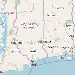
Map view of Mono Transboundary Biosphere Reserve

Use this park location map to pinpoint Mono Transboundary Biosphere Reserve in Benin, understand its exact geographic position, and read its mapped placement within the surrounding landscape more clearly.

Pigeon | © OpenStreetMap contributors

Visualizing river deltas, coastal lagoons, and protected wetland habitats

Mono Transboundary Biosphere Reserve Photos and Landscapes

Visual documentation of Mono Transboundary Biosphere Reserve captures the ecological transition from freshwater river channels to coastal marine environments. Photographic records reveal complex wetland topography, mangrove networks, and inland savanna formations that define the protected landscape.

Aerial perspective looking over the wide, calm Mono River, flanked by dense green vegetation and palm trees, leading toward the distant horizon where the river meets the coastline.

A coastal landscape featuring tall coconut palm trees, dense green shrubs, and a small pool of water or lagoon in a tropical setting.

Park atlas

Compare surrounding regional geography and adjacent transboundary conservation landscapes

Other Parks Near Mono Transboundary Biosphere Reserve and Connected Protected Areas

Browsing other parks near Mono Transboundary Biosphere Reserve reveals connected wetland corridors and adjacent transboundary conservation zones. Comparing protected areas across the surrounding region helps trace broader ecological patterns and regional terrain differences.
Protected areaOuémé
About 49 km away#1 closest

East

Basse vallée de l'Ouémé, lagune de Porto-Novo, lac Nokoué: Benin Wetland and Protected Area

Geographic analysis of a major West African riverine and lagoon system

Spanning the lower reaches of the Ouémé River, this protected wetland area in southern Benin integrates complex fluvial and coastal landscapes. The territory includes Lake Nokoué and the Porto-Novo lagoon, creating a vital hydrological basin that supports seasonal floodplains, mangrove fringes, and significant ecological connectivity. Examine the mapped boundaries and natural terrain of this unique West African environmental corridor.

Area
916 km²
Relief
Lowland
Climate
Tropical
Access
Access unknown
A horizontal watercolor painting showing a soft, stylized forest landscape with rolling hills, diverse trees, and vegetation in shades of green, yellow, and purple.
Nature reserveAtlantique
About 72 km away#2 closest

Northeast

Forêt relique de Niaouli Nature Reserve: Geography and Protected Landscape Boundaries

A scientific forest refuge in the Atlantique region of southern Benin

The Forêt relique de Niaouli nature reserve covers 220 hectares of protected land, serving as a rare survivor of the semi-deciduous forest that once characterized this part of coastal Benin. This site provides researchers and geography enthusiasts with a deep look into riparian and plateau forest ecosystems. Its ongoing value stems from its long-term ecological data and unique position within the broader West African forest block.

Area
2.2 km²
Established
1997
Relief
Lowland
Climate
Tropical
A watercolor painting showing a panoramic view of a river landscape with lush green trees, grasses, and soft pink foreground flowers against a light sky.
Nature reserveBenin
About 86 km away#3 closest

Northeast

Forêt classée de la Lama: Nature Reserve Geography and Protected Area Landscape

A dense forest refuge located within the Dahomey Gap

The Forêt classée de la Lama is a significant nature reserve in Benin, characterized by its unique position in the Lama depression. This area preserves a crucial core of dense semi-deciduous forest surrounded by managed buffer zones. Examine the mapped terrain, hydrological features, and the distinct ecological role this reserve plays in West African forest conservation.

Area
162.5 km²
Established
1946
Relief
Lowland
Climate
Subtropical
Nature reserveAtlantique
About 92 km away#4 closest

East

Vallée du Sitatunga: Nature Reserve Geography and Wetland Protected Area Context

Community-managed marshland ecosystems in southern Benin

Vallée du Sitatunga encompasses over 67,000 hectares of diverse terrain in southern Benin, ranging from humid forest to expansive floodplains. As a community-led nature reserve, it preserves a vital network of waterways and swamp habitats that sustain rare species such as the sitatunga. This landscape focus offers clear insight into the protected basin geography of the Atlantique region.

Area
700 km²
Established
2009
IUCN
VI
Relief
Lowland
Biosphere reserveBenin
About 98 km away#5 closest

East

Réserve de biosphère de la Basse vallée de l’Ouémé: Geographic Overview and Protected Area Map

Coastal lagoon and river delta ecosystems in Benin

The Réserve de biosphère de la Basse vallée de l’Ouémé represents a significant protected landscape in southern Benin where riverine and marine influences converge. This biosphere reserve map highlights a dense network of mangroves, seasonally flooded grasslands, and freshwater lakes. Gain insights into the regional geography and hydrologic patterns of this important wetland complex.

Area
3,143.4 km²
Established
2020
Relief
Lowland
Climate
Tropical
A watercolor painting showing a soft, impressionistic landscape of Keta Lagoon, featuring patches of green vegetation, yellow grasses, and calm water against a light, airy background.
Protected areaVolta Region
About 101 km away#6 closest

Southwest

Keta Lagoon Protected Area: Coastal Wetland Geography and Regional Landscape Mapping

A vital ecological and cultural landscape in Ghana's Volta Region

Keta Lagoon represents a primary coastal wetland system in eastern Ghana. Spanning the coastline between sandy barriers and inland floodplains, this protected area features a unique mosaic of mangroves, tidal flats, and islands. Its role as a major waterbird habitat and the center of Anlo-Ewe cultural life makes it a significant site for understanding West African coastal geography and environmental conservation.

Area
1,200 km²
Established
1992
Relief
Lowland
Climate
Tropical
A soft watercolor painting of a wetland scene with green trees and reeds in the foreground and rolling hills in the background.
Protected areaZou Department
About 102 km away#7 closest

Northeast

Forêt marécageuse de Lokoli: Protected Alluvial Forest and Wetland Geography in Zou Department

A rare flooded ecosystem in southern Benin

Spanning approximately 500 hectares, Forêt marécageuse de Lokoli serves as a crucial refuge for primate species and native swamp-forest vegetation. The area illustrates a distinct alluvial geography, characterized by seasonal flooding from the Hlan stream that transforms the forest floor into a mosaic of shallow pools and dense, stilt-rooted woodland environments.

Area
5 km²
Relief
Lowland
Water
Major water bodies
Wildlife reserveVolta Region
About 118 km away#8 closest

West

Kalakpa Game Production Reserve: Atlas Overview of Protected Terrain in Ghana

Ecological mosaic landscape in the Volta Region

Kalakpa Game Production Reserve represents a diverse protected area where Borassus and Combretum woodlands meet semi-deciduous gallery forests. Situated on the foothills of the Togo Mountains, this reserve provides essential habitat in the forest-savanna transition of southeastern Ghana, defined by its rugged rocky hills and seasonal valley streams.

Area
320 km²
Established
1975
IUCN
VI
Relief
Upland

Common questions about visiting, size, designation, and location context for Mono Transboundary Biosphere Reserve

Mono Transboundary Biosphere Reserve FAQs for park facts, access, geography, and protected area context

Find quick answers about Mono Transboundary Biosphere Reserve, including protected-area facts, park geography, trail and visitor context, and how the park fits into its surrounding country and regional landscape.
MoriAtlas Explorer

Continue Your Protected Areas Search Across the Global Atlas

Deepen your exploration by continuing the structured search for national parks and protected areas worldwide. Utilize the comprehensive filtering capabilities to compare different conservation landscapes and refine your understanding of global park geography. Discover more about the distribution and characteristics of protected natural areas.

Global natural geography