Mori Atlas logo
Natural monumentGrutas del Palacio

A central Uruguayan natural monument defining the regional landscape and geological heritage

Grutas del Palacio Natural Monument: Protected Sandstone Landscapes and Geologic Atlas Mapping

(Monumento Natural Grutas del Palacio)

Grutas del Palacio serves as a major natural monument in the department of Flores, central Uruguay, protecting a distinct labyrinthine sandstone cavern formed by geological erosion. The site features an iron-rich ferrified sandstone shell supported by dozens of columnar pillars, standing as a primary geosite within the national protected area network. Through this geographic record, explore the physical boundaries, sedimentary formations, and territorial context of a site recognized for its scientific significance in the Late Cretaceous geological sequence.

natural monumentgeoparksandstone formationgeological reservesedimentary geologyCretaceous formations

Grutas del Palacio

Natural monument

Park overview

Structured park overview, official facts, and landscape profile for Grutas del Palacio

Grutas del Palacio park facts, protected area profile, and essential visitor context

Review the core facts for Grutas del Palacio, including designation, size, terrain, visitor scale, habitats, and operating context in one park-focused overview.

About Grutas del Palacio

Grutas del Palacio sits in the rolling interior of Uruguay, in the department of Flores, and represents a compact but geologically rich protected landscape centered on a single distinctive landform. The protected area covers roughly 45 hectares near the small locality of Marincho, about 46 kilometers north of Trinidad along the old alignment of Ruta Nacional N.º 3. Although modest in territorial extent, the site carries an outsized profile because it is the anchor of the country's first geopark and one of only a handful of geological natural monuments in Uruguay's national system of protected areas.

The natural monument's defining feature is a sandstone cavern that does not follow the typical karst or volcanic cave model. Instead, its structure was produced by the differential erosion and cementation of ancient sediments. About 70 million years ago, during the Late Cretaceous, sands accumulated in what is now central Uruguay; tens of millions of years later, those loose sands were hardened into rock through a process of iron-rich cementation, creating a rigid crust of ferrified sandstone. Underneath that crust, ongoing erosion removed the more vulnerable surrounding material, leaving the harder shell perched above a series of columnar sandstone pillars of roughly two meters in height. The visible face of the formation extends several meters across, though only about 40 meters of it are easily accessible to visitors.

Beyond its geology, the site has cultural resonance. Local tradition holds that the cavern was used as shelter by indigenous inhabitants, and there is an associated indigenous legend tied to the place, although no rock paintings are present here, in contrast with the nearby Chamangá rock art locality. The first formal geological study of the materials was carried out by Dr. Karl Walter, who led the Geology chair at the Faculty of Agronomy between 1909 and 1938 and whose work remains a reference for researchers today.

In contemporary protected-area terms, Grutas del Palacio was officially incorporated into Uruguay's National System of Protected Areas on 21 May 2013, through decree N.º 153/013. It also joined the Global Geoparks Network, becoming the second South American geopark after Araripe in Brazil. Within its wider territory, the Ecoparque Talice (Reserva de Flora y Fauna Dr. Rodolfo Talice) extends the site's role from purely geological conservation into biodiversity and environmental education.

Quick facts and research context for Grutas del Palacio

Grutas del Palacio is a natural monument (Monumento Natural) of about 45 hectares in Uruguay's department of Flores, incorporated into the Sistema Nacional de Áreas Protegidas in May 2013 under decree N.º 153/013. The protected site lies near the locality of Marincho, on the historic alignment of Ruta Nacional N.º 3, north of Trinidad and far inland from the coast.

Geologically, the reserve preserves sandstone formations attributable to the Late Cretaceous, referenced in the literature as the Miembro del Palacio of the Formación Asencio (or, under alternative nomenclature, the geosuelo del Palacio of the Formación Mercedes). The site is the anchor of the Grutas del Palacio Geopark, which is recognized internationally and houses the Ecoparque Talice within its territory.

Protection and recognition

Terrestrial conservation scope, designated year, and official recognition metrics.

Grutas del Palacio Protection Status and Designation History

Grutas del Palacio features documented terrestrial protection status established in the year 2013. Structured records outline the official designation history and management scope associated with this protected area.

Protection details

Protection scope
Terrestrial
Designated year
2013
Transboundary protection
No
Park context

Deeper park guide and search-rich context for Grutas del Palacio

Grutas del Palacio history, landscape, wildlife, and travel context

Explore Grutas del Palacio through its history, landscape character, ecosystems, wildlife, conservation priorities, cultural context, and seasonal travel timing in a structured park guide built for atlas discovery and search intent.

Why Grutas del Palacio stands out

Grutas del Palacio is best known for a single, striking geological attraction: a labyrinthine cavern-like structure whose roof is a ferrified sandstone shell resting on dozens of columnar supports roughly two meters tall, sculpted by erosion over tens of thousands of years. The site is also recognized for anchoring Uruguay's entry into the international geopark movement, becoming the second South American geopark after Araripe in Brazil. The combination of its Cretaceous sandstone origin, Tertiary-age hardening, and column-supported architecture gives the formation a visually distinct, almost monumental appearance that has earned it the comparison to a palace suggested by its name. It is treated both as a natural monument of national importance and as a flagship geosite within the broader Grutas del Palacio Geopark.
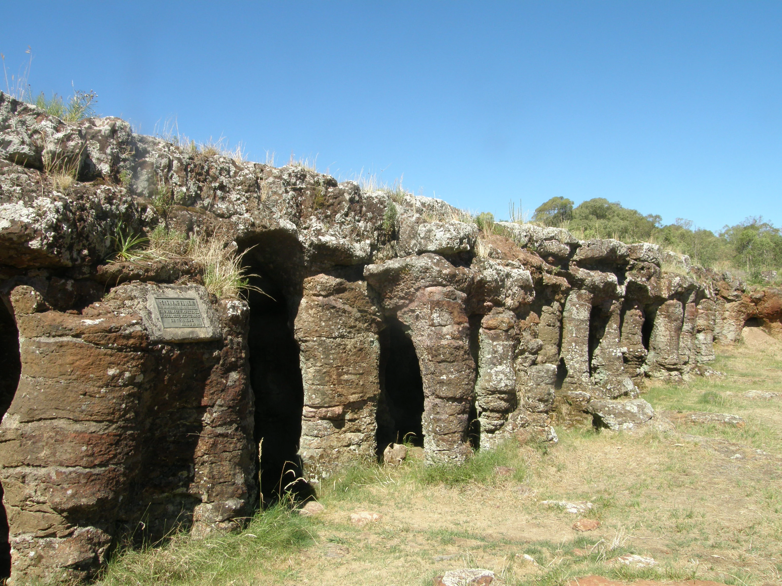
A wide angle view of a natural stone formation showing a series of eroded sandstone arches and columns in Flores, Uruguay.
The unique ferruginous sandstone columns and caverns of Grutas del Palacio.

Grutas del Palacio history and protected-area timeline

The visible geological history of Grutas del Palacio stretches back to the Late Cretaceous, around 70 million years ago, when the sediments that would become its rocks were first deposited in central Uruguay. The transformation of those loose sands into the ferrified sandstone observed today occurred later, during the early Tertiary, when iron-rich groundwater cemented the deposits into hard rock. Although the precise age of the cavern itself has not been definitively established, it is believed to be at least several tens of thousands of years old, and active studies continue to refine that chronology.

The cultural history of the site is more recent in human terms but layered. Local traditions and indigenous narratives associate the cavern with pre-colonial occupation; it is believed to have served as a dwelling for indigenous groups, and an indigenous legend is tied to the place. No rock paintings have been documented at Grutas del Palacio, distinguishing it from the nearby Chamangá rock art locality in the same region.

Modern scientific engagement began in the early twentieth century, when Dr. Karl Walter, who headed the Geology chair at Uruguay's Faculty of Agronomy from 1909 to 1938, conducted the first systematic geological study of the site's materials. His publications remain a reference for current researchers, and the site has continued to draw scientific and educational interest in subsequent decades.

The most significant modern milestone came on 21 May 2013, when decree N.º 153/013 formally incorporated Grutas del Palacio into Uruguay's National System of Protected Areas (SNAP) as a natural monument. In the same period, it joined the Global Geoparks Network, anchoring the country's first geopark and becoming the second geopark in South America, following the Araripe Geopark in Brazil. This recognition elevated the site from a regionally known geological curiosity to an internationally designated geosite.

Grutas del Palacio landscape and geographic character

The landscape of Grutas del Palacio is defined by gentle Uruguayan interior countryside, with the reserve itself set within a small area of rolling terrain in the department of Flores. The locality of Marincho provides the human context; the nearest major city is Trinidad, the departmental capital, located about 46 kilometers to the south along the historic alignment of Ruta Nacional N.º 3. Far from Uruguay's coast, the area lies inland in the country's central pastoral belt.

The dominant landscape feature is the cavern itself, which is not a typical cave formed in soluble rock but rather an erosional structure built from sandstone. A hardened cap of ferrified sandstone, a crust of iron-cemented rock, forms a roof over a series of columnar sandstone supports about two meters tall. Erosion has exposed this architecture as a labyrinthine front several meters across, of which only about 40 meters are easily accessible to the public. The result is a visually unusual landform: a natural structure that resembles a vaulted hall supported by pillars, which gave the site its suggestive name.

Grutas del Palacio ecosystems, habitats, and plant life

As a geological natural monument, Grutas del Palacio is primarily managed around the conservation of its sedimentary formations rather than a broad suite of ecosystems. The surrounding terrain falls within Uruguay's central inland landscape of pastoral countryside and low rolling relief, where native grasslands, shrubby vegetation, and patches of woodland intersect with agricultural land use.

The protected-area territory extends beyond the immediate geological feature and includes the Ecoparque Talice (Reserva de Flora y Fauna Dr. Rodolfo Talice), which broadens the site's ecological role into native flora and fauna conservation alongside the geological heritage. Together, these adjacent land uses give the broader geopark territory a mix of geological, grassland, and small-wildlife habitat character, even though the geologically anchored natural monument itself is small and tightly defined.

Grutas del Palacio wildlife and species highlights

The natural monument itself, focused on a single geological feature, does not host a distinctive or well-documented fauna of its own. However, the broader Grutas del Palacio Geopark and the Ecoparque Talice (Reserva de Flora y Fauna Dr. Rodolfo Talice) within its territory extend the site's natural values to include native flora and fauna, providing a context for wildlife observation and environmental education within the geopark setting.

The wider department of Flores and the central Uruguayan countryside surrounding the reserve support typical inland species associated with grasslands, gallery vegetation, and small woodland patches, including both native and rural fauna. Because the protected designation emphasizes geology rather than wildlife, the site is best understood ecologically as a geological reserve embedded in, and complementing, the broader pastoral and native-grassland landscape of central Uruguay.

Grutas del Palacio conservation status and protection priorities

Grutas del Palacio's conservation significance rests equally on its geological character and on its institutional recognition. As a natural monument, it protects a singular erosional landform, a ferrified sandstone crust supported by columnar pillars, that is rare both nationally and regionally. Without formal protection, such a localized geological feature would be vulnerable to extractive activities, infrastructure works, or unregulated tourism pressure. The natural-monument designation provides a formal framework for guarding the site's scientific and scenic values.

The site's importance extends beyond its boundaries through its anchor role in the Grutas del Palacio Geopark. Joining the Global Geoparks Network in conjunction with its 2013 incorporation into the Sistema Nacional de Áreas Protegidas brought international recognition of the site's geoheritage and tied its management into wider geoconservation frameworks. The inclusion of the Ecoparque Talice within the geopark territory links geological conservation with biodiversity and environmental education, broadening the conservation footprint of the site beyond a single rock formation.

In practical terms, the reserve helps safeguard a record of Late Cretaceous sedimentation and early Tertiary iron cementation, processes that illuminate the deep geological history of central Uruguay. It also preserves a cultural-association layer: a place tied to indigenous oral tradition, even in the absence of rock paintings, and a landmark that helped launch Uruguay's modern geopark program.

Grutas del Palacio cultural meaning and human context

Grutas del Palacio carries a meaningful, if modest, cultural dimension tied to the indigenous peoples of Uruguay. Local tradition holds that the cavern served as a dwelling for indigenous inhabitants, and a specific indigenous legend is attached to the place. The site therefore sits within a regional heritage of indigenous use of natural shelters and rock formations in interior Uruguay.

Notably, despite this association, no rock paintings have been documented at Grutas del Palacio, distinguishing it from the nearby Chamangá rock art locality in the same broader region. The site's cultural identity is instead carried primarily by oral tradition and by twentieth-century scientific study, most notably the geological work of Dr. Karl Walter between 1909 and 1938, whose publications are still consulted today and tie the place into Uruguay's academic geoscience history.

Top sights and standout views in Grutas del Palacio

The defining highlight of Grutas del Palacio is the visual and geological singularity of its column-supported sandstone cavern, a ferrified sandstone roof resting on dozens of two-meter-tall sandstone pillars within a compact 45-hectare natural monument. The site also stands out as the anchor of Uruguay's entry into international geopark networks, joining the Global Geoparks Network alongside its 2013 designation as a protected natural monument under decree N.º 153/013.

Complementing these strengths is the site's layered role: a geosite of Cretaceous sedimentary origin, a cultural site associated with indigenous use and legend, and a multi-use protected landscape that includes the Ecoparque Talice within its broader territory. Together, these traits make Grutas del Palacio one of the most distinctive geological reserves in Uruguay and the nucleus of the country's first geopark.

Best time to visit Grutas del Palacio

Grutas del Palacio lies in central Uruguay, where the climate is temperate with four well-defined seasons and relatively mild conditions year-round. Spring and autumn tend to offer comfortable temperatures, softer light on the sandstone formations, and the green countryside typical of Uruguay's pastoral interior, which suits both exploration of the geological site and enjoyment of the wider geopark landscape.

Summer brings warmer weather and longer daylight hours, useful for visiting the geological feature and the on-site interpretation areas, while winter is cooler and can bring shorter days and occasionally wetter ground conditions around the cavern approach. Because the site is primarily a geological and educational reserve rather than a wildlife-focused park, seasonality has more effect on comfort and landscape atmosphere than on visitor access fundamentals. Travelers should plan around mild weather windows for the most rewarding experience of the rock formation and its surrounding countryside.
Monthly climate preview

Long-term representative point measurements tracking monthly temperature and precipitation cycles

Grutas del Palacio Climate Normals, Annual Temperature and Precipitation Rhythm

Historical monitoring data from the representative coordinate records sustained annual temperature ranges and steady daily precipitation rates across all twelve months. Examining the complete monthly climatology profile provides deeper analytical insight into long-term environmental patterns across the protected landscape.
Annual mean17 °C
9 °C24 °C
Jan24°
Feb23°
Mar21°
Apr17°
May13°
Jun10°
Jul
Aug11°
Sep13°
Oct16°
Nov19°
Dec22°
Warmest month
January

23.9 °C

Coolest month
July

9.4 °C

Wettest month
February

4.3 mm/day

Driest month
July

2.5 mm/day

Park location guide

Geography guide, regional context, and park location map for Grutas del Palacio

Grutas del Palacio park geography, regions, and map view in Uruguay

Understand where Grutas del Palacio sits in Uruguay through a broader geographic reading of the surrounding landscape, nearby location context, and its mapped position within the national park landscape.

How Grutas del Palacio fits into Uruguay

Uruguay is a unitary presidential republic located in southeastern South America. It covers approximately 176,215 km² and has a population of nearly 3.5 million people. The capital and largest city is Montevideo, where roughly 2 million people live in the metropolitan area. Uruguay gained independence between 1825 and 1828 following territorial disputes involving Portugal, Spain, Brazil, and the United Provinces of the Río de la Plata.

Wider geography shaping Grutas del Palacio in Uruguay

Uruguay is situated in the southeastern part of South America, bordering Argentina to its west and southwest, Brazil to its north and northeast, the Río de la Plata estuary to the south, and the Atlantic Ocean to the southeast. The terrain consists primarily of rolling plains and low hills, with the highest point being Cerro Catedral at approximately 514 meters. The country has several rivers including the Uruguay River, Paraná River, and Negro River.

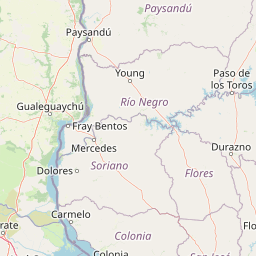
Map view of Grutas del Palacio

Use this park location map to pinpoint Grutas del Palacio in Uruguay, understand its exact geographic position, and read its mapped placement within the surrounding landscape more clearly.

Pigeon | © OpenStreetMap contributors

Location context for Grutas del Palacio

Flores

Visualizing the sandstone cavern formations and protected terrain of Uruguay

Grutas del Palacio Photos and Scenery: Exploring the Geological Landscape

Browse detailed photographs of Grutas del Palacio to examine its unique column-supported sandstone cavern and surrounding interior pastoral landscape. Visual records reveal the distinct geological architecture of the reserve, helping researchers understand its erosional landforms and protected-area character.

A wide angle view of a natural stone formation showing a series of eroded sandstone arches and columns in Flores, Uruguay.

Park atlas

Compare regional geography and connected protected landscapes across inland Uruguay

Explore Protected Areas and Parks Near Grutas del Palacio

Browse other parks near Grutas del Palacio to examine similar geological formations and protected natural monuments throughout the surrounding region. Extending the analysis beyond a single reserve reveals broader patterns in regional conservation topography and inland landforms.
Protected landscapeFlores Department
About 61 km away#1 closest

Southeast

Localidad Rupestre de Chamangá: An Archaeological Protected Landscape in Flores Department

Explorations into the prehistoric rock art of rural Uruguay.

Located in central Uruguay, Localidad Rupestre de Chamangá protects a sprawling 12,000-hectare rural landscape notable for its dense cluster of rare open-air pictographs. The site offers profound insights into how prehistoric art interacts with granite topography and pastoral terrain, bridging cultural heritage and natural landscape conservation in the department of Flores.

Area
120 km²
Established
2010
Relief
Upland
Climate
Subtropical
A soft, light-toned watercolor illustration of a river landscape with low green islands and marshy vegetation under a pale, minimalist sky.
National parkRío Negro Department
About 92 km away#2 closest

Northwest

Parque nacional Esteros de Farrapos e Islas del Río Uruguay: Protected Wetland Geography

Exploring the fluvial island and riverine terrain of Río Negro

This protected area represents an essential riverine ecosystem along the western frontier of Uruguay. The landscape comprises a complex layering of flood-prone plains, riparian forest edges, and silty soil formations that characterize the regional geography of the Río Uruguay basin.

Area
215.65 km²
Established
2008
Relief
Lowland
Scope
Terrestrial
Wildlife reserveRío Negro Department
About 94 km away#3 closest

Northwest

Área de manejo de hábitats y/o especies Esteros y Algarrobales del Río Uruguay Protected Area Geography

Wildlife reserve in the Río Negro department with unique riparian corridors.

This wildlife reserve protects a unique transition zone where dry-forest Prosopis woodlands thrive alongside wetland esteros. Its mapped terrain reflects the intersection of two distinct ecoregions, creating a fragile landscape characterized by blanqueales soils, gallery forests, and river-fed floodplains within a larger protected conservation mosaic.

Area
15.5 km²
Relief
Lowland
Scope
Terrestrial
Water
Major water bodies
A horizontal watercolor painting depicting a meandering river flowing through a green, hilly landscape with trees and soft, pastel lighting.
Protected areaPaysandú
About 129 km away#4 closest

North

Área protegida con recursos manejados Montes del Queguay: Geography and Protected Boundaries

Managed-resource landscape in the Paysandú river network

This protected area centers on a distinct floodplain basin in Paysandú, where silty soils and river confluence dynamics support a unique mosaic of riparian forest and wetland terrain. Explore the structural geography of this significant native woodland complex and its role within Uruguay's protected land system.

Area
434.1 km²
Established
1994
Relief
Lowland
Climate
Subtropical
A horizontal watercolor illustration of a gentle landscape with rolling green hills, a winding river, and a light-colored mountainous horizon.
National parkColonia Department
About 136 km away#5 closest

Southwest

Parque Nacional Aarón de Anchorena: Protected Geography and Riverine Landscape

An expansive arboretum and presidential estate in Colonia

Parque Nacional Aarón de Anchorena is a protected territory in southwestern Uruguay, defined by its position on the Río de la Plata estuary. The area encompasses an extensive arboretum, ornamental gardens, and riparian habitats that house unique animal populations. The site serves as a vital geographic anchor for the region, combining historic architecture with the broad, reflective horizons of the river coast.

Area
13.69 km²
Established
1908
Relief
Lowland
Climate
Temperate
National parkEntre Ríos Province
About 180 km away#6 closest

Northwest

El Palmar National Park: Protected Area Atlas and Geographic Exploration in Entre Ríos

Discover mapped park boundaries and regional landscape context.

El Palmar National Park offers a dedicated space for understanding protected landscapes within Argentina. As a designated national park situated in Entre Ríos Province, it serves as a crucial point for exploring mapped natural terrain and regional geography. This entry provides specific details on its protected area status and its contribution to the broader atlas of conservation lands in the Mesopotamia region.

Area
85 km²
Established
1966
IUCN
II
Access
Easy access
A watercolor painting of a wetland scene showing green, marshy areas and gentle, rolling hills in the background with soft brushwork.
Protected landscapeMontevideo
About 181 km away#7 closest

Southeast

Humedales de Santa Lucía Protected Landscape: Geography and Mapped Wetland Boundaries in Uruguay

A dynamic tidal freshwater system located near the Montevideo riverfront

Humedales de Santa Lucía is a significant protected landscape spanning the departments of San José, Canelones, and Montevideo. This managed wetland ecosystem is defined by the interaction between freshwater river discharge and the brackish tidal influence of the Río de la Plata estuary, creating a unique riparian mosaic of channels, islands, and marshlands important to local waterbird populations.

Area
865.17 km²
Established
2015
Relief
Lowland
Access
Easy access
Watercolor painting showing a hill with green landscape and distant mountains
National parkUruguay
About 206 km away#8 closest

Southeast

Arequita National Park: Uruguay's National Park Protected Landscape and Geography

Mapped boundaries and regional natural terrain context for a key protected area.

Delve into Arequita National Park, a designated national park contributing to Uruguay's protected land inventory. This resource explores the park's unique geographic setting, its mapped boundaries, and its significance within the natural landscape of the Southern Cone. Gain structured insight into its role as a protected area and its contribution to the regional geography of South America.

Scope
Terrestrial
Water
No major water

Common questions about visiting, size, designation, and location context for Grutas del Palacio

Grutas del Palacio FAQs for park facts, access, geography, and protected area context

Find quick answers about Grutas del Palacio, including protected-area facts, park geography, trail and visitor context, and how the park fits into its surrounding country and regional landscape.
MoriAtlas Explorer

Continue Your Protected Areas Search Across the Global Atlas

Deepen your exploration by continuing the structured search for national parks and protected areas worldwide. Utilize the comprehensive filtering capabilities to compare different conservation landscapes and refine your understanding of global park geography. Discover more about the distribution and characteristics of protected natural areas.

Global natural geography