Mori Atlas logo
Nature reserveMörschieder Burr

Discover the geographic character of this distinct quartzite summit within the Idarwald forest region.

Mörschieder Burr Nature Reserve: Mapping Quartzite Ridges and Protected Landscapes in Rhineland-Palatinate

(Naturschutzgebiet Mörschieder Borr (Burr))

Mörschieder Burr is a compact nature reserve located in the Birkenfeld district of Rhineland-Palatinate, serving as a critical geological feature along the Hunsrück uplands. The protected area centers on a prominent quartzite ridge that rises to 646 meters, characterized by exposed scree slopes that contrast sharply with the surrounding dense state forest. Now integrated into the Hunsrück-Hochwald National Park boundary zone, the reserve offers a clear look at the geological formation of the southern Idarwald.

quartzite ridgerocky outcropsscree slopesprotected foreststate forestlow mountain range

Mörschieder Burr

Nature reserve

Park overview

Structured park overview, official facts, and landscape profile for Mörschieder Burr

Mörschieder Burr park facts, protected area profile, and essential visitor context

Review the core facts for Mörschieder Burr, including designation, size, terrain, visitor scale, habitats, and operating context in one park-focused overview.

About Mörschieder Burr

Mörschieder Burr is a small, historically established nature reserve in the German state of Rhineland-Palatinate, focused on a single forested ridge in the southern Idarwald. Designated as a Naturschutzgebiet (NSG) in 1940, it predates Germany's modern large-scale national park initiatives and was created specifically to safeguard an unusual geological and forest landscape around the Mörschieder Burr hill, a quartzite peak rising to about 646 meters.

The reserve lies southwest of the village of Mörschied, in the Birkenfeld district, and forms part of the Mörschieder Wald state forest. Its compact footprint of roughly 19.7 hectares is shaped like a narrow ridge, about 1.12 kilometers long and at most around 270 meters wide, giving the protected area a clearly linear, hilltop character rather than a broad mosaic of habitats.

The site's modern significance is closely tied to the 2015 establishment of the Hunsrück-Hochwald National Park. With this designation, Mörschieder Burr was placed inside the Nationalpark's outermost Nature Zone 1b, the development zone that surrounds and buffers the more strictly protected core zone. As a result, a protective designation first set in place more than seventy years earlier now sits within the framework of one of Germany's largest contiguous protected forest areas, reinforcing its role as a small but ecologically and geologically meaningful component of the Hunsrück's protected landscape network.

Quick facts and research context for Mörschieder Burr

Mörschieder Burr is a designated nature reserve (NSG 7134-076) located in the Birkenfeld district of Rhineland-Palatinate, Germany, within the municipality of Mörschied in the Verbandsgemeinde Herrstein. Established in 1940, it covers about 19.7 hectares within the Mörschieder Wald state forest in the southern Idarwald section of the Hunsrück.

The reserve occupies a quartzite ridge at elevations between roughly 550 and 646 meters, with its highest point being the Mörschieder Burr hill itself. Since 2015, the area has been incorporated into the Nature Zone 1b (development zone) of the Hunsrück-Hochwald National Park, making it part of Germany's newest major national park context. The site is reached by marked hiking trails, including the long-distance Saar-Hunsrück-Steg, which passes over the summit.

Protection and recognition

Documented conservation status, official designation history, and administrative records

Mörschieder Burr Protection Status And International Recognition Records

Mörschieder Burr conservation metrics provide structured access to documented protection status and official designation history. Evaluated records outline management scope and international recognition frameworks associated with the protected landscape.

Protection details

WDPA ID
82188
Park context

Deeper park guide and search-rich context for Mörschieder Burr

Mörschieder Burr history, landscape, wildlife, and travel context

Explore Mörschieder Burr through its history, landscape character, ecosystems, wildlife, conservation priorities, cultural context, and seasonal travel timing in a structured park guide built for atlas discovery and search intent.

Why Mörschieder Burr stands out

Mörschieder Burr is best known for its prominent quartzite rock outcrops and largely bare scree slopes on the southeastern flank of the hill, an unusual geological feature within the otherwise heavily forested Idarwald. The reserve preserves these Taunus quartzite formations, which give the protected area its character and clearly stand out from the surrounding woodland. Its position on the northeast edge of the Hunsrück-Hochwald National Park adds to its significance as a long-established nature reserve that now sits inside one of Germany's largest contiguous protected forest landscapes. The combination of compact size, dramatic exposed rock, and easy access via major hiking trails makes it a recognizable point of interest for visitors exploring the Hunsrück's geological and forest heritage.
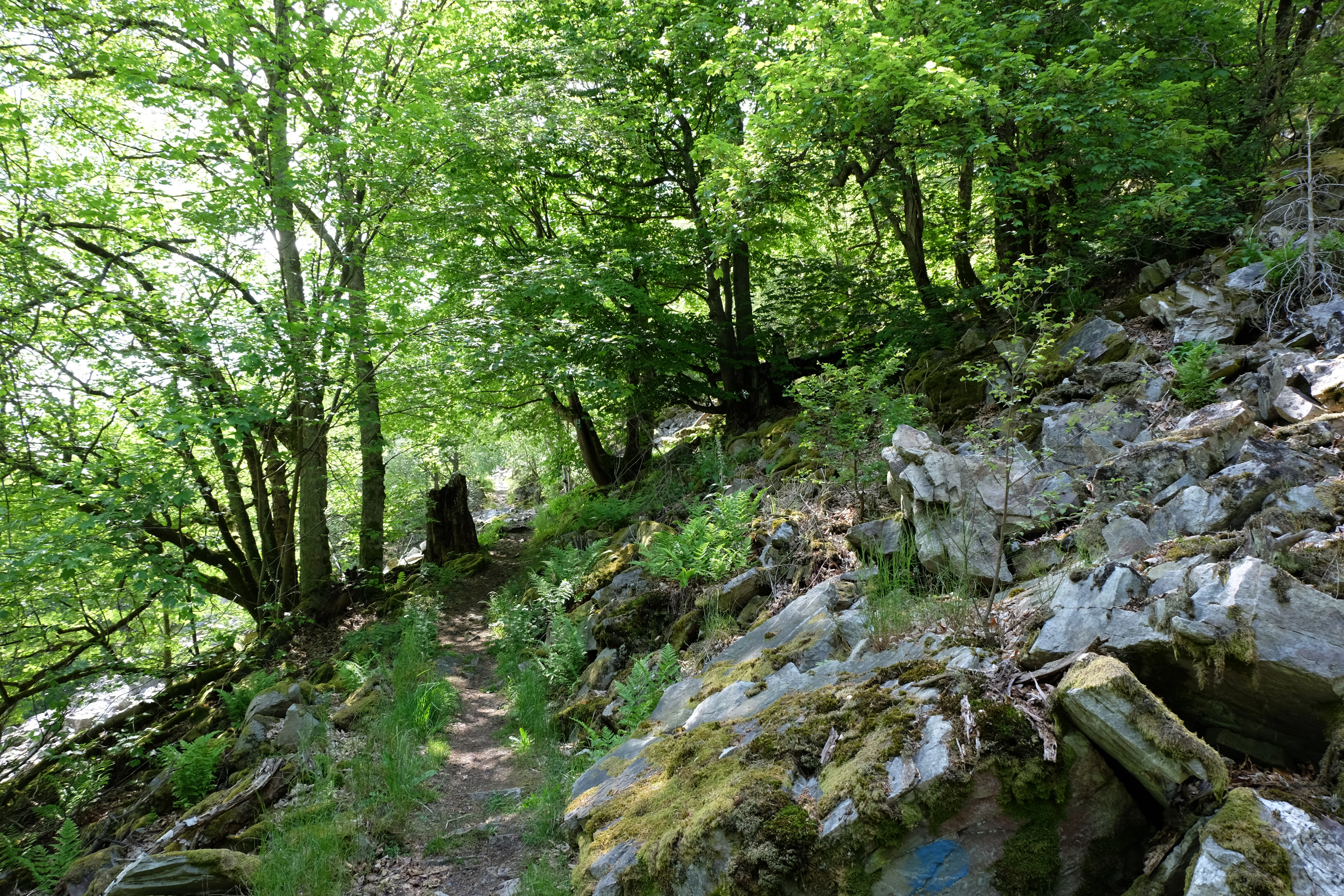
A narrow, dirt hiking trail cuts through a dense, green forest with large, jagged quartzite rock formations covered in moss along the right side of the path.
A narrow hiking path winds through the forested slopes of Mörschieder Burr, flanked by mossy quartzite rock formations.

Mörschieder Burr history and protected-area timeline

Mörschieder Burr was formally designated as a Naturschutzgebiet in 1940, making it one of the older protected areas in the present-day Birkenfeld district of Rhineland-Palatinate. Its establishment at that time reflected the early German tradition of securing small, distinctive natural sites, in this case a quartzite ridge and its associated rock and forest landscape in the southern Idarwald, against exploitation and uncontrolled change.

For decades the reserve existed as an isolated protected island within the broader Hunsrück forest region. This changed significantly in 2015, when the Hunsrück-Hochwald National Park was established to the south and west, and the original NSG became part of the new Nationalpark's Nature Zone 1b, the development zone that surrounds the more strictly regulated core area. The integration brought Mörschieder Burr into a coordinated large-scale conservation framework while preserving its original 1940 designation and boundaries.

Mörschieder Burr landscape and geographic character

The landscape of Mörschieder Burr is dominated by a single quartzite ridge running through the southern Idarwald, a heavily wooded portion of the central Hunsrück. The protected area stretches for about 1.12 kilometers along the ridge and never exceeds roughly 270 meters in width, producing a clearly elongated, hilltop-protected zone rather than a broad valley or basin reserve.

Elevations within the reserve range from approximately 550 to 646 meters, with the summit formed by the Mörschieder Burr, a hill composed of resistant Taunus quartzite. The southeastern flank of the hill exposes largely vegetation-free quartzite rock faces and scree slopes set against an otherwise closed forest canopy, creating one of the most visually distinctive open-rock features in the surrounding Hunsrück forest.

The reserve is embedded in the Mörschieder Wald state forest, surrounded by coniferous and mixed woodland typical of the upland Hunsrück. A short distance to the southwest lies the Wildenburger Kopf, another prominent quartzite summit associated with the Wildenburg castle ruins and the separate Naturschutzgebiet Wildenburg, situating Mörschieder Burr within a geological landscape of repeated quartzite highs separated by deeply wooded saddles.

Mörschieder Burr ecosystems, habitats, and plant life

Ecologically, Mörschieder Burr is a small forest reserve defined by the contrast between dense woodland and open rock. Most of the area is covered by forest typical of the Hunsrück uplands, growing on acidic quartzite substrate and shaped by the regional climate of the central German low mountain range. This continuous forest canopy is what gives the reserve its basic ecological character as a protected woodland stand.

The defining natural feature, however, is the geological interruption of that canopy on the southeastern slope of the summit. Here, quartzite outcrops and scree fields remain largely free of vegetation, providing rare warm, dry microhabitats in an otherwise shaded and moist forest environment. Such rock-and-scree openings are limited in the Hunsrück and contribute disproportionately to habitat diversity within the surrounding forest matrix, supporting specialized flora and fauna adapted to thin soils, high sun exposure, and rocky substrate.

The reserve's 2015 incorporation into the Hunsrück-Hochwald National Park's outer development zone extends the ecological context of the site well beyond its narrow boundaries, linking its small but distinctive rock-forest mosaic to one of Germany's largest contiguous protected forest landscapes.

Mörschieder Burr conservation status and protection priorities

Mörschieder Burr has been under formal nature protection since 1940, originally designated to preserve a distinctive quartzite hill and its forest setting in the southern Idarwald. As one of the older Naturschutzgebiete in the Birkenfeld district, it has long served as a small but stable refuge for the rock and forest habitats tied to the Taunus quartzite geology of the central Hunsrück.

Its conservation significance was substantially reinforced in 2015, when it was placed within Nature Zone 1b of the newly established Hunsrück-Hochwald National Park. Although Zone 1b is a development zone rather than the strictly regulated core zone, inclusion in the Nationalpark framework connects the small reserve to broader goals of large-scale, process-oriented forest protection, habitat connectivity, and the safeguarding of geological features within one of Germany's most extensive new national park contexts.

Mörschieder Burr cultural meaning and human context

The Mörschieder Burr reserve sits within the traditional forest landscape of the Hunsrück, a low-mountain region long associated with small-scale forestry, state-managed woodlands, and a network of historic castles and ruins such as the nearby Wildenburg above the Wildenburger Kopf. The reserve is part of the Mörschieder Wald, a state forest holding that illustrates the long-standing relationship between the regional communities and the wooded uplands surrounding the village of Mörschied.

Marked hiking trails, including longer-distance routes such as the Saar-Hunsrück-Steg, cross the area and connect the quartzite summit to broader regional trail networks. These paths reflect the modern cultural role of the Hunsrück forests as recreational landscapes, layered on top of older patterns of forestry use and proximity to historical sites such as the Wildenburg castle ruins just southwest of the reserve.

Top sights and standout views in Mörschieder Burr

Mörschieder Burr's highlights center on its 646-meter quartzite summit, its striking vegetation-free scree slopes on the southeastern flank, and its position along the Saar-Hunsrück-Steg long-distance hiking trail, which passes directly over the peak. The reserve's inclusion in the Hunsrück-Hochwald National Park adds another layer of interest, situating a 1940 nature reserve within the framework of one of Germany's newest large national parks.

Within the broader Hunsrück protected-area network, Mörschieder Burr is small in area, roughly 19.7 hectares, but distinctive in character, offering an unusually clear example of Taunus quartzite geology in a region otherwise defined by closed forest cover.

Best time to visit Mörschieder Burr

The reserve can be visited year-round along its marked trails, but spring and early autumn are generally the most rewarding seasons. In spring, the surrounding woodlands revive with fresh foliage and mild temperatures make the hike to the summit comfortable, while early autumn brings stable weather, clear views from the exposed quartzite ridge, and rich forest coloration.

In winter, exposed quartzite rock can become slippery and the open scree slopes feel considerably harsher, so winter visits generally call for sturdy footwear. Summer visits are pleasant in the forest sections but can be warm on the bare southeastern rock faces, which receive strong direct sunlight.

Monthly climate preview

Track long-term monthly averages across the representative park coordinate in Rhineland-Palatinate

Mörschieder Burr Climate Normals, Annual Temperature and Precipitation Rhythm

Representative coordinates record long-term monthly temperature spans and daily precipitation rates across the landscape. Deeper weather records provide a complete twelve-month climate profile for comprehensive analysis.
Annual mean9 °C
0 °C19 °C
Jan
Feb
Mar
Apr
May13°
Jun16°
Jul19°
Aug19°
Sep14°
Oct
Nov
Dec
Warmest month
July

18.9 °C

Coolest month
January

-0.1 °C

Wettest month
December

2.3 mm/day

Driest month
April

1.5 mm/day

Park location guide

Geography guide, regional context, and park location map for Mörschieder Burr

Mörschieder Burr park geography, regions, and map view in Germany

Understand where Mörschieder Burr sits in Germany through a broader geographic reading of the surrounding landscape, nearby location context, and its mapped position within the national park landscape.

How Mörschieder Burr fits into Germany

Germany is a federal republic in Western and Central Europe with a population of over 83 million across sixteen constituent states. It is Europe's largest economy by nominal GDP and a major global exporter and importer. The capital is Berlin, and the country borders Denmark, Poland, Czech Republic, Austria, Switzerland, France, Luxembourg, Belgium, and the Netherlands.

Wider geography shaping Mörschieder Burr in Germany

Germany is located in Western and Central Europe, spanning 357,022 km². It borders Denmark to the north, Poland and the Czech Republic to the east, Austria and Switzerland to the south, and France, Luxembourg, Belgium, and the Netherlands to the west. The country has coastlines on the Baltic Sea and North Sea to the north, with the Alps located in the southern region.

Map view of Mörschieder Burr

Use this park location map to pinpoint Mörschieder Burr in Germany, understand its exact geographic position, and read its mapped placement within the surrounding landscape more clearly.

Pigeon | © OpenStreetMap contributors

Location context for Mörschieder Burr

Rhineland-Palatinate

Visualizing quartzite rock formations, exposed scree slopes, and protected forest habitats across the reserve.

Mörschieder Burr Photos and Landscape Scenery in the Hunsrück Uplands

Visual documentation captures the stark contrast between exposed Taunus quartzite rock formations and the surrounding continuous forest canopy of the Hunsrück uplands. Photographic records provide clear reference material for studying the distinct geological topography and upland habitat structure of the protected reserve.

A narrow, dirt hiking trail cuts through a dense, green forest with large, jagged quartzite rock formations covered in moss along the right side of the path.

Park atlas

Compare nearby national parks and connected protected landscapes across the Hunsrück uplands.

Exploring Parks Near Mörschieder Burr, Protected Areas in the Surrounding Region

Visitors exploring Mörschieder Burr can compare adjacent protected areas and nearby national park zones across the surrounding forest landscape. Extending the geographic review allows researchers to examine related quartzite ridges, wooded uplands, and connected regional reserves.
Watercolor painting of a forested landscape with rolling hills and distant mountains under a pale sky
National parkSaarland
Mapped location lies within the park boundary#1 closest

Southwest

Hunsrück-Hochwald National Park: Saarland Protected Area Atlas and Landscape Context

Explore the mapped terrain and protected geography of this German national park.

Delve into the specific geography and protected landscape of Hunsrück-Hochwald National Park in Saarland. This detail page provides an atlas-centric view of the park's mapped boundaries, regional context, and its role as a national park. It serves as a foundational point for understanding the park's landscape features and its placement within the broader geographic atlas.

Area
100 km²
Established
2015
IUCN
II
Relief
Mountain
Watercolor painting of rolling green hills, small forest patches, and rocky outcrops under a soft, white background.
National parkRheinland-Pfalz
Mapped location lies within the park boundary#2 closest

Southwest

Nationalpark Hunsrück-Hochwald: An Atlas and Geographic Overview of Protected Lands

Upland forest ecosystems and quartzite mountain terrain

The Hunsrück-Hochwald region showcases the transition of industrial-era forests toward near-natural wilderness. Its mapped territory integrates significant beech wood blocks with smaller wetland systems, reflecting a commitment to long-term biodiversity within the German uplands. Explore the structural composition and landscape features that define this protected zone.

Area
101.2 km²
Established
2015
IUCN
II
Relief
Mountain
Nature reserveRhineland-Palatinate
About 6.3 km away#3 closest

Northwest

Naturschutzgebiet Spring Nature Reserve: Protected Wetland and Headwater Landscape Geography

Mapped upland habitats in the Hunsrück, Rhineland-Palatinate

Naturschutzgebiet Spring protects a specialized wetland complex, featuring headwater streams and peatland formations within the Idarwald. This conservation area highlights the fragile, water-dependent ecology of the Hunsrück, providing a clear geographic view of preserved mire and swamp forest terrain within Rhineland-Palatinate.

Area
0.74 km²
Established
1988
Relief
Upland
Scope
Terrestrial
Protected areaRheinland-Pfalz
About 18 km away#4 closest

Southeast

Truppenübungsplatz Baumholder: Protected Area and Geological Landmark in Rheinland-Pfalz

A vast military training ground and Natura 2000 ecological sanctuary.

Truppenübungsplatz Baumholder is a expansive protected landscape in Rheinland-Pfalz, functioning as both an active military installation and a preserved natural habitat. The terrain features a striking mix of dense deciduous forest, open firing corridors, and unusual volcanic geological remnants like rare lava flows and agate deposits. This site serves as a critical study in how restricted access shapes regional biodiversity.

Area
116 km²
Established
1937
Relief
Upland
Access
Highly restricted
A soft, painterly watercolor illustration of a rolling landscape with patches of forest, light green fields, and distant hazy hills.
Protected landscapeRheinland-Pfalz
About 21 km away#5 closest

Northeast

Soonwald Protected Landscape: Mapped Quartzite Ridges and Forested Massifs in Rhineland-Palatinate

Geographic analysis of the Hunsrück ridge system and protected natural terrain

The Soonwald is a significant quartzite-dominated ridge system within the German Hunsrück. This protected landscape encompasses 40 kilometers of uninterrupted crestlines, deep valley incisions, and ecological forest reserves. It offers a detailed study in mountain geography and ridge-dominated topography for those interested in the structural layout of the Rhineland-Palatinate natural environment.

Area
276.6 km²
Relief
Mountain
Climate
Temperate
Access
Easy access
Nature reserveSaarland
About 24 km away#6 closest

Southwest

Wiesenkomplex bei Eisen Nature Reserve: Geography and Protected Habitat Mapping in Saarland

A mosaic of meadow and riparian stream ecosystems

Located in northern Saarland, Wiesenkomplex bei Eisen protects a mosaic of traditionally managed wet and semi-dry grasslands. The reserve, centered on the Krippbach stream, supports essential floodplain gallery forests and diverse meadow types. This mapping of four non-contiguous sites underscores the role of structured management in preserving remnant cultural landscape habitats within the region.

Area
0.9 km²
Established
2016
IUCN
IV
Relief
Lowland
Nature reserveSaarland
About 28 km away#7 closest

Southwest

Südteil des Nohfeldener Rhyolith-Massivs: Saarland Nature Reserve and Volcanic Highland Terrain

Protected montane grasslands and rare bog woodland habitats.

This nature reserve protects 73 hectares of critical habitat within the Saarland uplands. Defined by the rhyolite massif geology between Losenberg and Leißberg, the protected area maintains rare montane mat-grass swards and fragile bryophyte communities. The site serves as a vital example of volcanic landscape conservation, highlighting the intersection of acidic silicate soils and specific ecological biodiversity in Germany.

Area
0.73 km²
Established
2017
IUCN
IV
A horizontal watercolor painting of rolling green hills, a small stream, and forested slopes against a pale sky.
Protected areaRheinland-Pfalz
About 28 km away#8 closest

Southeast

Königsberg Protected Area: Geography, Forest Habitats, and Regional Landscape Identity

Examining the mountain ridges of the Nordpfälzer Bergland

Königsberg stands as a prominent mountain massif in the German state of Rheinland-Pfalz. This protected landscape is characterized by deep mixed beech-oak forests, significant geological scree formations, and an intricate history of mining. Its ridge-line terrain provides a critical study of upland geography, separating regional valleys while hosting a diverse array of protected natural habitats and medieval heritage sites.

Area
10.47 km²
Relief
Mountain
Climate
Temperate
Access
Moderate access

Common questions about visiting, size, designation, and location context for Mörschieder Burr

Mörschieder Burr FAQs for park facts, access, geography, and protected area context

Find quick answers about Mörschieder Burr, including protected-area facts, park geography, trail and visitor context, and how the park fits into its surrounding country and regional landscape.
MoriAtlas Explorer

Continue Your Protected Areas Search Across the Global Atlas

Deepen your exploration by continuing the structured search for national parks and protected areas worldwide. Utilize the comprehensive filtering capabilities to compare different conservation landscapes and refine your understanding of global park geography. Discover more about the distribution and characteristics of protected natural areas.

Global natural geography