
Mori Atlas logo
Nature reserveMoßmörken

A compact mosaic of inland dunes, lowland bogs, and near-natural forest ecosystems in northwestern Germany

Moßmörken Nature Reserve: Mapped Protected Landscapes and Geographic Features in North Rhine-Westphalia

(Naturschutzgebiet Moßmörken)

Moßmörken serves as a significant protected nature reserve within the Steinfurt district of North Rhine-Westphalia. This site preserves a rare geological mosaic where post-glacial inland dunes sit alongside remnants of lowland bogs and nutrient-poor wetlands. By analyzing the terrain and mapped boundaries, observers can study the complex ecological interactions between dry sandy substrates and waterlogged peaty soils that define this portion of the Münsterland region.

nature reservelowland boginland duneswet grasslandnear-natural forestnutrient-poor waters
A digital illustration of a scenic mountain landscape featuring rocky cliffs, a central waterfall, a calm lake with lily pads in the foreground, and silhouetted tree branches framing the top and sides.

Moßmörken

Nature reserve

Park overview

Structured park overview, official facts, and landscape profile for Moßmörken

Moßmörken park facts, protected area profile, and essential visitor context

Review the core facts for Moßmörken, including designation, size, terrain, visitor scale, habitats, and operating context in one park-focused overview.

About Moßmörken

Moßmörken is a compact nature reserve in the western part of North Rhine-Westphalia, situated between the towns of Hörstel and Rheine. Although small in area, it captures an unusually diverse package of habitats that are otherwise scarce in the intensively used lowlands of the Münsterland.

The reserve's core profile is defined by the presence of a lowland bog (Niedermoor) together with inland dunes, a pairing that reflects the glacial and post-glacial history of the region. Around and between these features, near-natural forests, wet shrubs, and wet grassland communities have developed over time, while small open water bodies with nutrient-poor conditions support characteristic shoreline and floating vegetation.

Designated as a nature reserve in 1995 under the official code ST-098 and renewed in 2017, Moßmörken is part of the wider constellation of protected sites managed within the Kreis Steinfurt. Its location near major infrastructure corridors, including the A30 motorway and the Dortmund-Ems Canal, highlights its role as a surviving ecological refuge within a heavily transformed landscape.

Quick facts and research context for Moßmörken

Moßmörken (designated code ST-098) is a nature reserve spanning roughly 13 hectares on the municipal territory of Hörstel and Rheine within Kreis Steinfurt, North Rhine-Westphalia. It was first designated in 1995 and reissued under a renewed ordinance in 2017.

The site belongs to IUCN Category IV, classifying it as a Habitat/Species Management Area, and is recorded in the World Database on Protected Areas. Its value rests on a combination of bog deposits, inland dunes, near-natural forest, wetland vegetation, and nutrient-poor open water, making it a compact but ecologically and geologically significant component of the regional protected-area network.

Protection and recognition

Explore terrestrial protection records, management designations, and official recognition sources for Moßmörken

Moßmörken Protection Status and Documented Conservation Scope

Examine the verified terrestrial protection status and documented conservation scope governing Moßmörken across official geographic records. Review baseline designation metrics and international recognition frameworks associated with this protected natural area.

Protection details

Protection scope
Terrestrial
Transboundary protection
No
WDPA ID
555638617
Park context

Deeper park guide and search-rich context for Moßmörken

Moßmörken history, landscape, wildlife, and travel context

Explore Moßmörken through its history, landscape character, ecosystems, wildlife, conservation priorities, cultural context, and seasonal travel timing in a structured park guide built for atlas discovery and search intent.

Why Moßmörken stands out

Moßmörken is best known for the combination of lowland bog remnants and inland dunes, which gives the reserve both ecological and earth-historical significance. The site also protects near-natural forests, wet shrub communities, species-rich wet grassland, and nutrient-poor waters with characteristic marsh and shoreline vegetation.
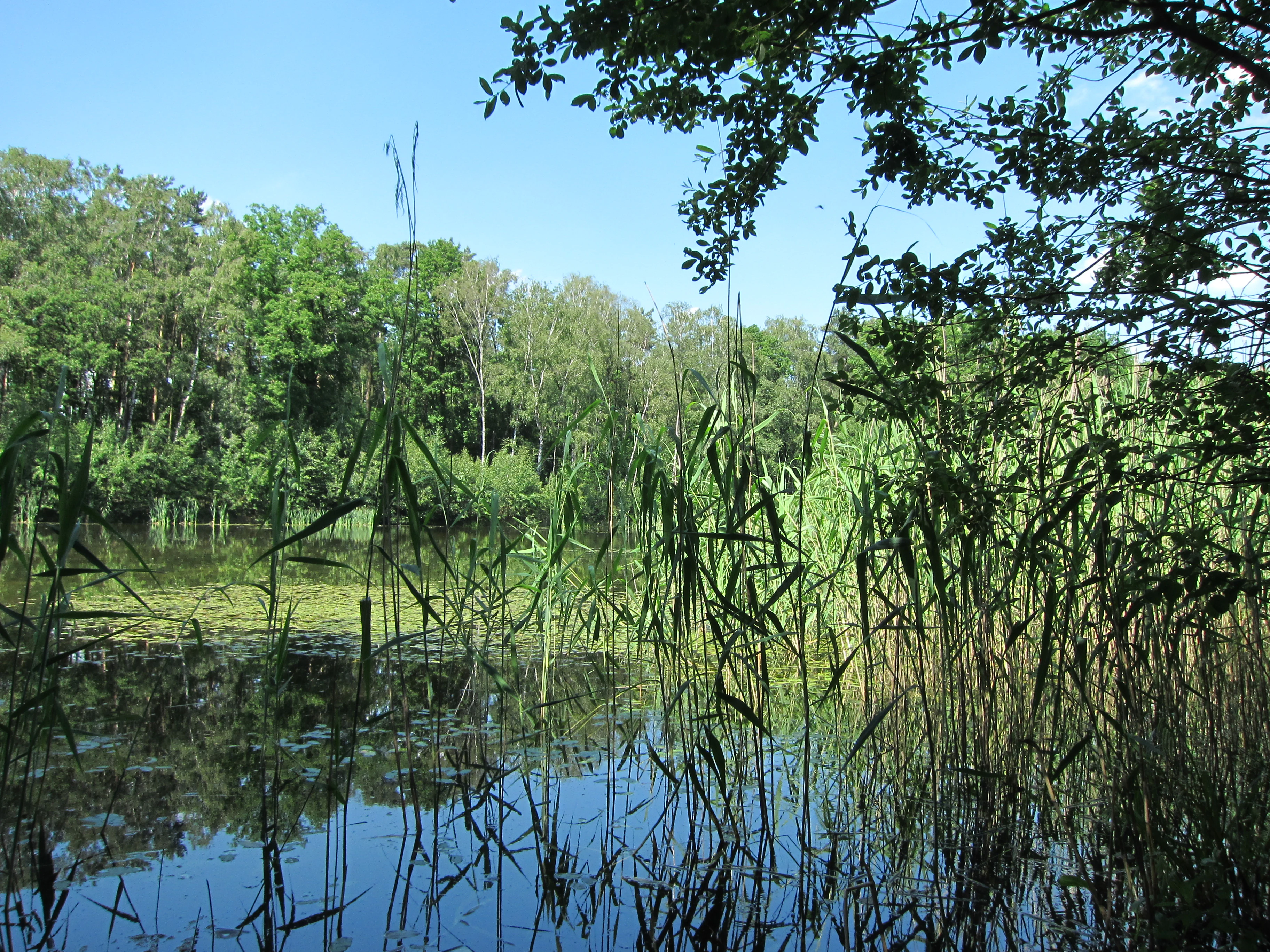
A calm, still lake in the Moßmörken nature reserve, surrounded by thick green forest with tall reeds growing in the foreground.
The waters of the Torfmoorsee, framed by lush reeds and woodland at the Moßmörken nature reserve.

Moßmörken history and protected-area timeline

Moßmörken has been formally protected as a nature reserve since 1995, when an area of approximately 13 hectares on the territory of the cities of Hörstel and Rheine was designated under the code ST-098.

In 2017, the regulatory ordinance establishing the protection of the area was renewed and reissued by the Münster district government, reaffirming the site's protected status and updating its formal framework. This reissue reflects the ongoing administrative care given to the reserve, even though the core area and its protection objectives remained essentially unchanged.

Moßmörken landscape and geographic character

The landscape of Moßmörken reflects the geological and ecological layering typical of the western Münsterland. Inland dune formations sit alongside lowland bog surfaces, a juxtaposition shaped by the region's earth history during and after the last glaciation.

Between and around the bog and dune features, the terrain supports near-natural forest stands and shrubby vegetation. Nutrient-poor open water bodies with fringing marsh vegetation add further variety to the topography, creating a small but varied mosaic of dry sandy substrates and waterlogged, peaty ground within a short distance of one another.

Moßmörken ecosystems, habitats, and plant life

Moßmörken protects a tightly interwoven mosaic of habitats, including near-natural woodland, shrubs, wet grassland (Feuchtgrünland), and nutrient-poor water bodies. The shoreline and shallow-water zones support Verlandungsvegetation, the gradual transition zone where open water fills with marsh plants.

Equally important are the site's bog and dune elements. The Niedermoor, or lowland bog, represents a remnant peatland landscape, while the inland dunes preserve sandy dryland conditions. Together, these elements create a rare small-scale alternation of wet and dry, nutrient-poor and modestly nutrient-rich conditions that sustains distinctive plant communities.

Moßmörken wildlife and species highlights

Because Moßmörken protects a rare mix of bog, dune, woodland, and wetland habitats, it provides refuge for plant and animal species whose preferences span these environments. The reserve's stated conservation objective explicitly includes the protection of the plant and animal communities dependent on near-natural forests, shrubs, wet grassland, and nutrient-poor waters with marsh vegetation, as well as on the bog and dune systems themselves.

Moßmörken conservation status and protection priorities

Moßmörken's conservation role is defined by goal of preserving and restoring near-natural forest, shrub, wet grassland, and nutrient-poor water communities, alongside the dependent plant and animal species. A specific additional objective is the protection of the Niedermoor and dune features for their earth-historical significance, recognizing these landforms as landscape monuments in addition to habitat.

Classified under IUCN Category IV as a Habitat/Species Management Area, Moßmörken contributes a small but specialized piece to the regional protected-area network in Kreis Steinfurt, helping to maintain the traditional bog and dune character of the western Münsterland in a landscape otherwise dominated by agriculture and infrastructure.

Top sights and standout views in Moßmörken

The reserve's most distinctive points of interest include its inland dunes, which are unusual examples of sandy, dry-ground conditions in a region otherwise characterized by heavier soils and wet landscapes, and its lowland bog remnants, which preserve traces of the area's post-glacial land-forming processes. The presence of nutrient-poor open waters with classical marsh succession vegetation further enhances the reserve's ecological interest.

Despite covering only about 13 hectares, Moßmörken stands out for combining forest, shrub, grassland, open water, and bog-dune elements in a single protected site, making it a notably compact and varied piece of the regional nature conservation network.

Best time to visit Moßmörken

As a small protected nature reserve focused on habitat and species management rather than visitor infrastructure, Moßmörken is best appreciated during the warmer months, when woodland and grassland vegetation are in full development and bog and dune plant communities are most easily observed. Spring and early summer are particularly suitable for recognizing the contrast between wet bog vegetation and dry dune vegetation. Visitors should treat the area as a quiet natural landscape rather than a developed tourist site, respecting the conservation goals that underlie its designation.

Monthly climate preview

Long-term representative point measurements tracking monthly climate patterns for Moßmörken

Moßmörken Climate Normals: Annual Temperature and Precipitation Rhythm

Representative coordinate records show measured temperature and daily precipitation values across all twelve months for Moßmörken. Examining the full monthly climate profile reveals detailed long-term averages for annual temperature ranges and precipitation rhythms.
Annual mean10 °C
1 °C18 °C
Jan
Feb
Mar
Apr
May13°
Jun16°
Jul18°
Aug18°
Sep14°
Oct10°
Nov
Dec
Warmest month
July

18.2 °C

Coolest month
January

1.4 °C

Wettest month
December

2.4 mm/day

Driest month
April

1.4 mm/day

Park location guide

Geography guide, regional context, and park location map for Moßmörken

Moßmörken park geography, regions, and map view in Germany

Understand where Moßmörken sits in Germany through a broader geographic reading of the surrounding landscape, nearby location context, and its mapped position within the national park landscape.

How Moßmörken fits into Germany

Germany is a federal republic in Western and Central Europe with a population of over 83 million across sixteen constituent states. It is Europe's largest economy by nominal GDP and a major global exporter and importer. The capital is Berlin, and the country borders Denmark, Poland, Czech Republic, Austria, Switzerland, France, Luxembourg, Belgium, and the Netherlands.

Wider geography shaping Moßmörken in Germany

Germany is located in Western and Central Europe, spanning 357,022 km². It borders Denmark to the north, Poland and the Czech Republic to the east, Austria and Switzerland to the south, and France, Luxembourg, Belgium, and the Netherlands to the west. The country has coastlines on the Baltic Sea and North Sea to the north, with the Alps located in the southern region.

Map view of Moßmörken

Use this park location map to pinpoint Moßmörken in Germany, understand its exact geographic position, and read its mapped placement within the surrounding landscape more clearly.

Pigeon | © OpenStreetMap contributors

Location context for Moßmörken

North Rhine-Westphalia

Explore the unique terrain, lowland bog remnants, and inland dunes of Moßmörken through field photography.

Moßmörken Photos and Landscape Scenery: Visualizing Protected Habitats

Visual records capture the rare mosaic of lowland bog remnants, inland dunes, and near-natural forest environments characterizing Moßmörken. Photographic documentation reveals the subtle topographical shifts between sandy dry ground and waterlogged peaty terrain across the protected landscape.

A calm, still lake in the Moßmörken nature reserve, surrounded by thick green forest with tall reeds growing in the foreground.

Park atlas

Discover related nature reserves and connected regional geography in Münsterland

Exploring Parks Near Moßmörken and Surrounding Protected Landscapes

Browsing other protected areas near Moßmörken reveals a broader mosaic of lowland bogs, inland dunes, and river valley habitats across the regional conservation network. Comparing adjacent terrain provides essential context for understanding post glacial landforms and habitat distribution throughout the Münsterland.
Nature reserveNordrhein-Westfalen
About 3.7 km away#1 closest

West

Zachhorn Nature Reserve: Protected Heathland and Wetland Landscapes in Nordrhein-Westfalen

Geographic atlas of the Ems valley heathland pond refuge.

Zachhorn is a defined nature reserve in the Steinfurt district, protecting two shallow ponds and surrounding acidic heathland characteristic of the Ems valley lowlands. This site provides a rare, nutrient-poor aquatic environment that supports specialized wetland flora and essential amphibian habitats, forming a distinct piece of the regional conservation mosaic in Nordrhein-Westfalen.

Area
0.214 km²
Established
1990
IUCN
IV
Nature reserveNorth Rhine-Westphalia
About 17 km away#2 closest

Southeast

In den Hiärken Nature Reserve: Mapped Protected Area and Wetland Geography in Steinfurt

A fragmented mosaic of wet meadow habitats in North Rhine-Westphalia

Located in the Münsterland region, In den Hiärken consists of six separate parcels that form a vital wet-habitat network. The landscape is defined by its low-lying, undulating terrain and moisture-rich soils, standing in stark contrast to the surrounding agricultural fields and major infrastructure routes such as the A 1 motorway and Dortmund-Ems Canal.

Area
1.664 km²
Established
1992
A soft watercolor painting of a rolling landscape with green fields, scattered evergreen and deciduous trees, and distant hills under a light sky.
Nature reserveNorth Rhine-Westphalia
About 19 km away#3 closest

Northeast

Koffituten Nature Reserve and the Protected Bog Landscapes of North Rhine-Westphalia

A study of raised bog regeneration and inland dune ecosystems.

Koffituten provides a clear look at bog restoration and land management within the Steinfurt district. This nature reserve protects a rare raised bog island alongside a mix of pine-oak forest, fen woodland, and inland dunes. Its compact size and historical restoration work make it a focal point for understanding the interplay between wetland and dry-land habitats in the German lowlands.

Area
0.236 km²
Established
1991
Relief
Lowland
Climate
Temperate
A watercolor illustration of a rolling grassy landscape with a cluster of pine and deciduous trees on a white background.
Protected areaGermany
About 20 km away#4 closest

Southeast

Hüttruper Heide Protected Area: Münsterland Heathland Geography and Maps

A compact and scientifically significant nature reserve in North Rhine-Westphalia.

Hüttruper Heide serves as a concentrated example of historic Westfalian heathland. The area features a distinct geological contrast between dry heath ridges and moist, molinia-filled depressions. It remains a key case study in landscape conservation, highlighting the ongoing tension between industrial infrastructure expansion and the survival of rare, fragmented plant habitats.

Area
0.123 km²
Established
1938
Relief
Lowland
Climate
Temperate
Nature reserveLandkreis Grafschaft Bentheim
About 27 km away#5 closest

West

FFH-Gebiet Bentheimer Wald: A Deep Dive into German Protected Woodland and Forest Terrain

Historic wood pasture in Landkreis Grafschaft Bentheim

Explore the geographical structure and protected status of FFH-Gebiet Bentheimer Wald. This woodland region is renowned for its Hutewald heritage, riparian streams, and ancient growth that supports rare lichen and bryophyte species across its expansive lowland forest canopy.

Area
7.8 km²
Relief
Lowland
Climate
Temperate
Access
Access unknown
Nature reserveLandkreis Osnabrück
About 30 km away#6 closest

North

Swatte Poele: Protected Heath Ponds and Glacial Moraine Geography in Landkreis Osnabrück

A mapped nature reserve and FFH habitat area.

The Swatte Poele nature reserve protects a distinctive glacial complex where shallow heath ponds meet wet mires and dry sandy heaths. Located within the Fensterberge end moraine, the site functions as an important ecological node in the broader European habitat network. This detailed map and landscape overview examines the terrain transitions and conservation status of this small yet biologically dense German protected area.

Area
0.043 km²
Established
1976
Nature reserveNiedersachsen
About 31 km away#7 closest

West

Syen-Venn Nature Reserve: Geographic Overview of Mired Landscapes in Lower Saxony

A study of raised bog regeneration, peatlands, and wetland bird habitats

Syen-Venn is a prominent nature reserve in Niedersachsen, characterized by its long-standing history of mire conservation and active bog surface regeneration. The landscape features diverse structural elements including cottongrass-covered hummocks, nutrient-poor standing waters, and moor birch woodlands that provide essential habitat within the broader regional geography of northern Germany.

Area
1.96 km²
Established
1936
Nature reserveGrafschaft Bentheim
About 31 km away#8 closest

West

Weiher am Syen-Venn Nature Reserve: Protected Landscapes and Geography in Grafschaft Bentheim

Exploring nutrient-poor ponds and meadow buffer zones

Weiher am Syen-Venn stands as a significant nature reserve in Grafschaft Bentheim, defined by its flat lowland terrain and aquatic-focused ecological zones. The protected area encompasses nearly 30 hectares of meadows and ponds, providing vital refuge for moor frogs and migratory bird species within an agricultural landscape framework.

Area
0.28 km²
Established
2016
Relief
Lowland
Climate
Temperate

Common questions about visiting, size, designation, and location context for Moßmörken

Moßmörken FAQs for park facts, access, geography, and protected area context

Find quick answers about Moßmörken, including protected-area facts, park geography, trail and visitor context, and how the park fits into its surrounding country and regional landscape.
MoriAtlas Explorer

Continue Your Protected Areas Search Across the Global Atlas

Deepen your exploration by continuing the structured search for national parks and protected areas worldwide. Utilize the comprehensive filtering capabilities to compare different conservation landscapes and refine your understanding of global park geography. Discover more about the distribution and characteristics of protected natural areas.

Global natural geography