
Mori Atlas logo
Wildlife reserveMount Adams Wilderness

Tracing the dramatic ecological divide between high altitude meadows and dense coniferous forests

Mount Adams Wilderness: Exploring the Volcanic Geography and Protected Landscapes of the Cascade Range

Mount Adams Wilderness encompasses a massive stratovolcano and its rugged surrounding terrain within the southern Washington Cascades. This protected area features a striking east-west climatic gradient, where rain-drenched western forests transition into drier eastern pine woodlands across a landscape shaped by ancient lava flows, glaciers, and subalpine basins. The region provides a complex geographic study of volcanic activity and glacial carving near the Pacific Crest National Scenic Trail.

volcanic landscapesubalpine meadowsCascade Rangewilderness areamountain climbingPacific Crest Trail
A minimalist vector illustration of a snow-capped volcanic mountain peak rising above a dense coniferous forest at sunset.

Mount Adams Wilderness

Wildlife reserve

Park overview

Structured park overview, official facts, and landscape profile for Mount Adams Wilderness

Mount Adams Wilderness park facts, protected area profile, and essential visitor context

Review the core facts for Mount Adams Wilderness, including designation, size, terrain, visitor scale, habitats, and operating context in one park-focused overview.

About Mount Adams Wilderness

Mount Adams Wilderness encircles the western half of Mount Adams, a towering stratovolcano that dominates the skyline of south-central Washington. Although the summit itself is shared with surrounding tribal and recreation lands, the designated wilderness forms a protective ring around the mountain's forested slopes, ridges, and glacial valleys. With more than 47,000 acres of congressionally protected terrain, it ranks among the more substantial wilderness areas in the southern Cascades and provides a continuous corridor of relatively undisturbed habitat between the wet forests of the western Cascades and the drier pine woodlands of the eastern ranges.

The defining feature of the wilderness is Mount Adams itself, a 12,276-foot volcano that is not only tall but also one of the most voluminous in the Cascades. Its broad shoulders support numerous glaciers, ice-streaked gullies, and lava flows that radiate outward in long, finger-like ridges. Late-Pleistocene volcanic activity is still visible at features such as Potato Hill, a cinder cone rising 800 feet above its surrounding lava plain on the mountain's north side. The interplay of older lava flows, more recent glacial scouring, and ongoing erosion gives the terrain a layered, geologically textured character that is unusual in the Cascades.

Ecologically, the wilderness sits astride the Cascade Crest, so it captures the climatic transition between the moist maritime forests of western Washington and the more continental forests and steppe that characterize the eastern slopes. The western side is cloaked in dense conifer stands fed by abundant precipitation, while the eastern side features open ponderosa pine forests, parklands, and dry meadows. Above these forests, subalpine parklands and wildflower-rich meadows ring the higher elevations, sprinkled across lava flows and broken rimrock. This east-west gradient makes the wilderness unusually compact in ecological terms: a single hike can pass through multiple vegetation zones.

The wilderness draws a wide range of users. It is a destination for backpacking, equestrian travel, day hiking, and serious mountaineering, since the South Spur route on the mountain's south side is one of the more accessible nontechnical climbs of a major Cascade peak. Roughly 21 miles of the Pacific Crest Trail traverse the area, linking the wilderness into the broader Pacific Crest network. Because the higher terrain remains snow-covered from late autumn until early summer, and because of the volcanic hazards associated with climbing above 7,000 feet, the wilderness has both a strong seasonal rhythm and a clear management framework overseen by the U.S. Forest Service.

Quick facts and research context for Mount Adams Wilderness

Mount Adams Wilderness is a congressionally designated wilderness within the Gifford Pinchot National Forest, located in south-central Washington near the Oregon border. It preserves the western slopes and surrounding forests of Mount Adams, a 12,276-foot stratovolcano that ranks as the second-highest summit in Washington and one of the most voluminous peaks in the Cascade Range.

The wilderness covers approximately 47,700 acres across Yakima and Skamania counties, with its access point in the small community of Trout Lake. It is managed by the U.S. Forest Service under the National Wilderness Preservation System and is classified as an IUCN Category Ib protected area. Snow lingers on the higher elevations well into summer, and a Volcano Pass is required for activities above 7,000 feet, reflecting the active volcanic nature of the landscape.

Protection and recognition

Explore documented terrestrial boundaries and conservation management records.

Mount Adams Wilderness Protection Status and Territorial Designation Facts

Mount Adams Wilderness maintains a structured terrestrial protection scope with verified designation records and administrative data. Protected area oversight details provide comprehensive reference metrics for this regional landscape.

Protection details

Protection scope
Terrestrial
Transboundary protection
No
Park context

Deeper park guide and search-rich context for Mount Adams Wilderness

Mount Adams Wilderness history, landscape, wildlife, and travel context

Explore Mount Adams Wilderness through its history, landscape character, ecosystems, wildlife, conservation priorities, cultural context, and seasonal travel timing in a structured park guide built for atlas discovery and search intent.

Why Mount Adams Wilderness stands out

Mount Adams Wilderness is best known for the sweeping volcanic terrain that surrounds Mount Adams, one of the largest and most glaciated stratovolcanoes in the Cascade Range. The wilderness showcases a dramatic east-west ecological contrast, with parched eastern forests giving way to dense western rainforests all on the flanks of the same massive peak. It is also recognized for its extensive subalpine meadows that bloom among lava flows and rimrocks, its glaciers and permanent snowfields, and its network of interconnected trails, most notably the Pacific Crest Trail, which threads around the mountain. The combination of an accessible but serious climb, alpine wildflower displays, and a strongly volcanic geological backdrop distinguishes the wilderness from many of its Cascade neighbors.
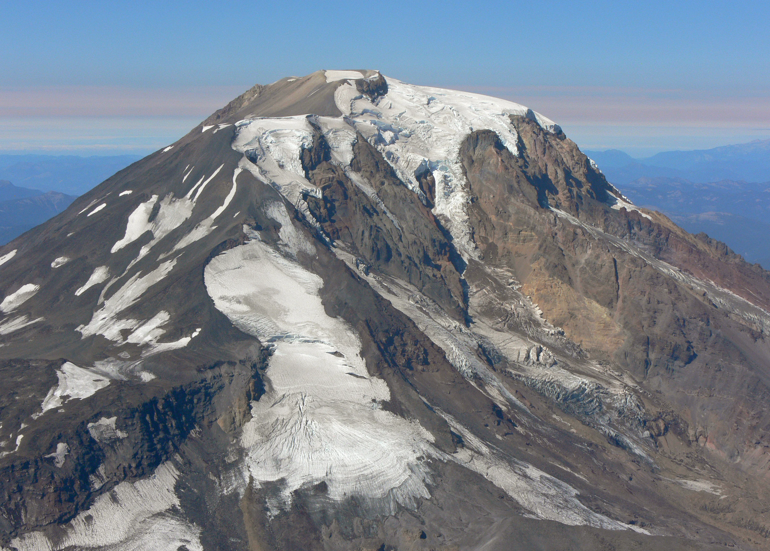
An aerial view of the snow-covered summit and glaciated slopes of Mount Adams, Washington.
An aerial view of the summit area of Mount Adams, showing its glaciers and rocky terrain.

Mount Adams Wilderness history and protected-area timeline

The Mount Adams Wilderness was formally established in 1964 as part of the larger movement to create a nationwide system of congressionally protected wilderness areas during that decade. Its designation brought federal recognition to a landscape that had long been used for hunting, grazing, and increasingly for recreation as the Pacific Crest Trail and adjacent forest roads developed in the twentieth century.

Although the wilderness itself dates to 1964, the broader landscape carries a much longer human and geological history. Mount Adams has been an active volcanic system for hundreds of thousands of years, with eruptions building the massive edifice seen today and producing lava flows and cinder cones, including Potato Hill, that date to the late Pleistocene. Potato Hill itself became a useful scientific site: a manual weather station operated there from 1950 to 1976, and an automated precipitation gauge was installed in 1982, later upgraded to also report snow water equivalent and snow depth, providing one of the longer continuous climate records from a Cascade subalpine site.

The eastern flank of the mountain carries additional human significance, falling within the lands of the Yakama Nation. Cultural ties to Mount Adams long predate formal wilderness designation, and the southeast side of the mountain is now managed in part as the Mount Adams Recreation Area, including the well-known Bird Creek Meadows. The wilderness's history is therefore shaped by the overlap of volcanic geology, federal conservation policy, contemporary recreation, and ongoing tribal stewardship of the larger Mount Adams landscape.

Mount Adams Wilderness landscape and geographic character

Mount Adams Wilderness sits within one of the most distinctive volcanic landscapes in the contiguous United States. Mount Adams is a large stratovolcano with broad, sloping shoulders rather than a single sharp peak, giving the surrounding terrain a heavily sculpted, ridged appearance. Lava flows of various ages radiate outward from the summit, and in places they form rugged bands of black rock that interrupt the surrounding forests. On the higher slopes, glacial action has carved cirques and steep gullies, leaving permanent snowfields and small glaciers clinging to the cooler aspects of the upper mountain.

At lower elevations, the landscape divides sharply between east and west. The western slopes are steep, forested, and deeply dissected by streams, with valleys running down toward the broader Gifford Pinchot landscape. The eastern side is gentler and drier, with more open forest, rolling terrain, and the wide, sky-filled horizons typical of the eastern Cascades. Potato Hill, the late-Pleistocene cinder cone on the north side, illustrates the volcanic character of the area in microcosm: a dark, conical rise sitting above its own flat lava plain, visible from miles around.

Above the forests, the high country is defined by subalpine meadows and parklands, where grasses and wildflowers mix with exposed lava boulders and rimrock. Streams descend from the snowfields in long, cascading reaches, and numerous small lakes and meadow basins punctuate the network of connecting ridges. The combination of volcanic, glacial, and fluvial processes has produced a landscape of unusual variety in a relatively compact area, with forested valleys, open alpine basins, and stark volcanic ridgelines all within sight of one another.
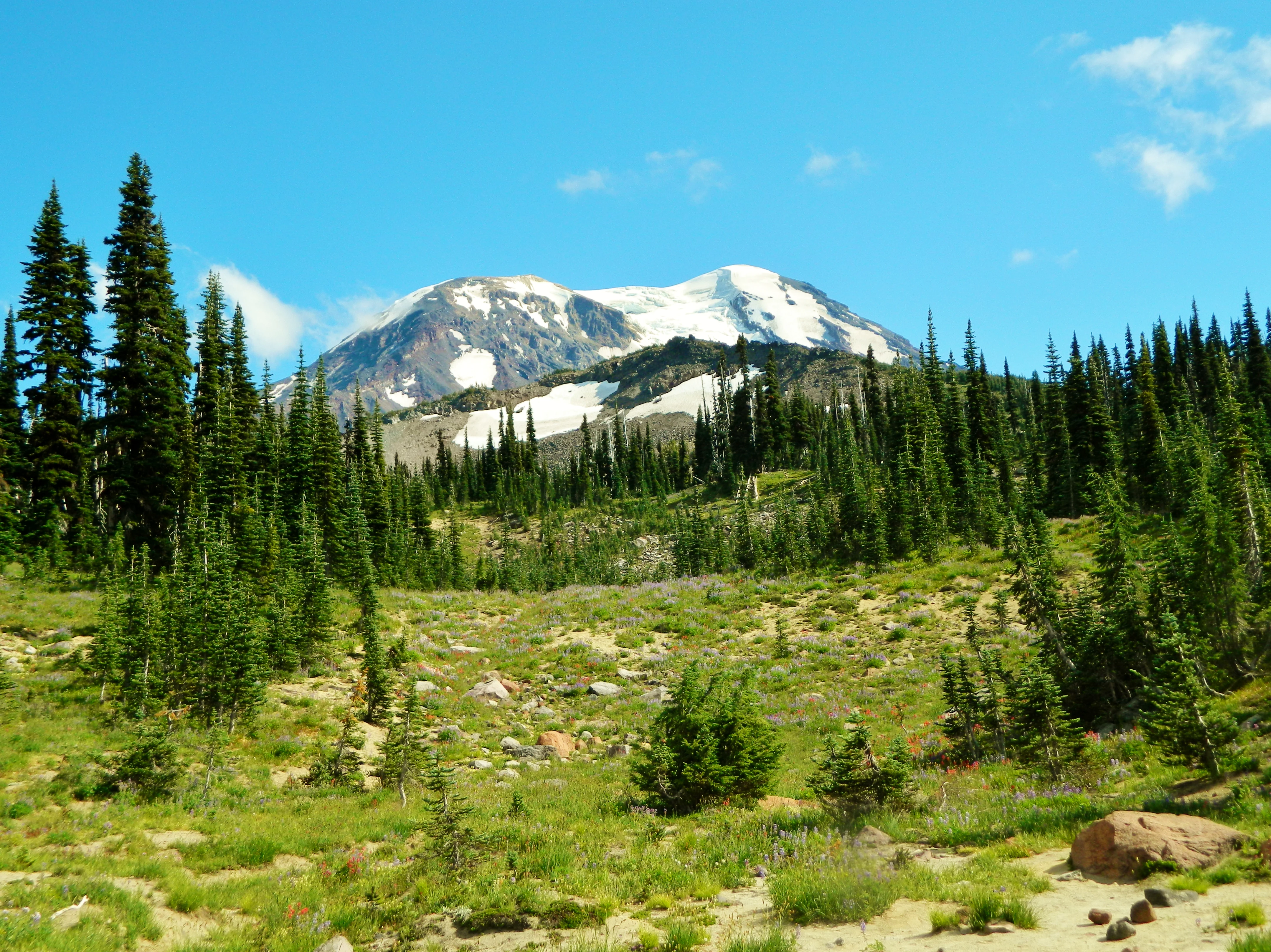
A wide shot showing a snow-capped mountain in the background, with a foreground of green alpine meadow, scattered rocks, and a dense forest of evergreen trees.
A scenic view of the glaciated peak of Mount Adams rising above subalpine meadows and conifer forests.

Mount Adams Wilderness ecosystems, habitats, and plant life

The ecological identity of Mount Adams Wilderness is shaped primarily by its position along the Cascade Crest, which produces a strong east-to-west gradient in climate, vegetation, and habitat character. On the western side of the mountain, abundant precipitation supports dense coniferous forest, dominated by Douglas-fir and western hemlock, with a mossy, shaded understory and a thick network of streams and wet draws. Moving eastward across the wilderness, forests give way to more open stands of ponderosa pine and mixed conifers, with drier soils and a more parklike appearance.

Above the montane forests lies a substantial subalpine zone, where trees thin into parklands and eventually give way to alpine meadows. In summer, these meadows support a rich display of wildflowers; around the higher portions of the wilderness, colorful blooms are scattered directly across lava flows and rimrock, creating the unusual ecological combination that the area is known for. Glacial melt and seasonal snowmelt feed meadows and small lakes, sustaining the moisture-loving plants of these higher basins.

Wildfire plays a recurring ecological role in the eastern, drier forests, and fire-adapted species and open stands reflect that history. The combination of dense wet forest to the west, dry ponderosa woodland to the east, and high-elevation subalpine habitat in between gives the wilderness a layered ecological profile: a relatively small area that nevertheless supports an unusually broad range of vegetation types and associated wildlife communities.

Mount Adams Wilderness wildlife and species highlights

The varied habitats of Mount Adams Wilderness support a wide range of Cascade wildlife typical of the southern Washington Cascades. In the forested western slopes, species associated with mature and old-growth conifer stands are present, along with animals that favor dense cover and abundant water. The drier eastern forests and open parklands host species more typical of the eastern Cascades, including those that thrive in mixed ponderosa and pine habitats with open ground for foraging and travel.

In the higher country around the mountain's shoulders, subalpine and alpine wildlife is the main draw. The meadows and talus slopes are important seasonal habitat for animals adapted to harsh, snowy winters and short, intense summers. Raptors are known to nest and hunt across the open terrain, and the wilderness's mix of cliffs, ridges, and meadow edges offers nesting and foraging habitat for birds of prey. The trails and trailside habitats also make the area accessible for visitors observing elk, deer, and small mammals in more open settings.

Because the wilderness straddles a strong ecological boundary, its wildlife communities reflect influences from both the wet western Cascades and the drier interior forests, giving the area a faunal character that combines elements otherwise separated by many miles of intervening terrain.

Mount Adams Wilderness conservation status and protection priorities

The Mount Adams Wilderness holds clear conservation value as a sizable, formally protected block of Cascade habitat surrounding one of the largest stratovolcanoes in the contiguous United States. Its 1964 designation under the National Wilderness Preservation System provides a high level of legal protection, restricting road building, mechanized use, and commercial development in order to preserve the area's wilderness character.

Beyond legal protection, the wilderness helps preserve a transition zone between western and eastern Cascade ecosystems. By protecting both dry ponderosa pine stands and moist montane conifer forests on the same mountain, the wilderness maintains ecological diversity at a scale that is increasingly rare in the Pacific Northwest. The area also protects significant volcanic and glacial landforms, including lava flows, the Potato Hill cinder cone, and active glaciers, which serve as both ecological anchors and scientific reference sites. The long-running weather station at Potato Hill, upgraded several times since 1982, is a small but telling example of the wilderness's role in long-term environmental monitoring.

The wilderness sits within the broader Gifford Pinchot National Forest and near the Yakama Nation's Mount Adams Recreation Area on the eastern flank of the mountain, situating it within a larger landscape of managed and tribal lands rather than as an isolated protected island.

Mount Adams Wilderness cultural meaning and human context

Mount Adams holds deep significance for the Yakama Nation, whose lands include much of the eastern side of the volcano. The summit and eastern flank are tied to long-standing cultural relationships between the Yakama people and the mountain, and certain areas on the Yakama side remain limited to tribal members, while others are open for recreation. The southeast side of the mountain is now framed in part by the Mount Adams Recreation Area, which includes Bird Creek Meadows, an area known for its summer wildflower displays.

For non-indigenous visitors and the broader public, Mount Adams has been a destination for climbers, hikers, and backcountry travelers since the twentieth century, particularly after the development of the Pacific Crest Trail and the broader road system within the Gifford Pinchot National Forest. The wilderness itself reflects the era's growing recognition of the area's ecological and scenic value, and its modern character is shaped by the interplay of recreational use, federal stewardship, and tribal management of the larger Mount Adams landscape.

Top sights and standout views in Mount Adams Wilderness

Mount Adams Wilderness offers a compact but dramatic survey of Cascade environments: rain-soaked western forests, dry eastern pine woodlands, subalpine meadows, lava flows, and glaciated high country, all wrapped around an iconic 12,276-foot volcano. Few other Cascade wildernesses combine a major stratovolcano with such a clear east-west ecological gradient inside a single protected boundary.

The wilderness is also notable for its recreational diversity, ranging from accessible day hikes through flowering meadows to the more demanding South Spur climbing route on Mount Adams, and including about 21 miles of the Pacific Crest Trail as it makes its way around the mountain. Combined with its long-standing research value, exemplified by the multi-decade climate record at Potato Hill, the area offers a wilderness experience that is simultaneously wild, scientifically significant, and central to the modern identity of the southern Washington Cascades.

Best time to visit Mount Adams Wilderness

The most favorable time to experience Mount Adams Wilderness is generally mid to late summer, once the deep seasonal snowpack has melted out of the meadows and trails at higher elevations. By July and August, the subalpine meadows around the mountain are typically in bloom, the trail network is largely snow-free below the highest ridges, and the South Spur climbing route is at its most accessible for nontechnical ascents.

Early autumn can also be a rewarding window, with cool temperatures, fewer mosquitoes in the meadows, and the first hints of fall color in the surrounding forests, though snowfall can return to the higher elevations by October. Winter and spring bring heavy snow that buries most trails and turns the wilderness into a high-alpine snow environment, suitable primarily for experienced mountaineers seeking ski touring or winter climbing on Mount Adams.

Monthly climate preview

Long-term representative temperature ranges and precipitation averages for Mount Adams Wilderness

Mount Adams Wilderness Climate Normals and Monthly Weather Patterns

Historical monitoring points record measured monthly fluctuations in average temperature and precipitation across Mount Adams Wilderness from 1991 to 2020. Examining the complete twelve-month climatology data reveals the broader baseline rhythms governing this protected landscape.
Annual mean7 °C
-2 °C17 °C
Jan-2°
Feb
Mar
Apr
May10°
Jun13°
Jul17°
Aug17°
Sep13°
Oct
Nov
Dec-2°
Warmest month
August

17 °C

Coolest month
December

-1.8 °C

Wettest month
December

5.8 mm/day

Driest month
July

0.4 mm/day

Park location guide

Geography guide, regional context, and park location map for Mount Adams Wilderness

Mount Adams Wilderness park geography, regions, and map view in United States of America

Understand where Mount Adams Wilderness sits in United States of America through a broader geographic reading of the surrounding landscape, nearby location context, and its mapped position within the national park landscape.

How Mount Adams Wilderness fits into United States of America

The United States of America is a federal presidential republic and one of the world's largest countries by area and population. It consists of 50 states across a vast territory spanning multiple time zones, with its capital in Washington, D.C. and largest city in New York City. The nation has a diverse economy, influential political system, and significant cultural and military presence globally.

Wider geography shaping Mount Adams Wilderness in United States of America

The United States occupies a vast territory in North America, bordered by Canada to the north and Mexico to the south. The 48 contiguous states stretch from the Atlantic to the Pacific Ocean, while Alaska occupies the northwestern region and Hawaii is an archipelago in the Pacific. The country encompasses diverse terrain including the Rocky Mountains, Appalachian Mountains, Great Plains, and extensive river systems.

Map view of Mount Adams Wilderness

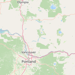
Use this park location map to pinpoint Mount Adams Wilderness in United States of America, understand its exact geographic position, and read its mapped placement within the surrounding landscape more clearly.

Pigeon | © OpenStreetMap contributors

Location context for Mount Adams Wilderness

Washington
Natural feature types

Explore Named Natural Features Within the Mount Adams Wilderness Landscape

Continue geographic discovery by browsing the identified landforms, glaciers, and water features associated with the Mount Adams Wilderness. MoriAtlas organizes these distinct natural elements to provide a clearer view of the terrain and ecological diversity defining this major Cascade Range volcanic area.
Recorded earthquake history

Explore the Historical Earthquake Records for Mount Adams Wilderness

Review a chronological catalogue of documented seismic events with epicentres near Mount Adams Wilderness. This dataset organizes historical earthquake records by magnitude and location to provide context for the seismic activity documented within this region of the Cascade Range.

Mount Adams Wilderness Earthquake History

Catalogued events

1,221 events

Strongest magnitude

Magnitude 5.7

Most recent event

Feb 7, 2024

This history includes earthquakes recorded inside the park or within 50 km of its borders

Visualizing volcanic terrain, subalpine meadows, and forest gradients in the Cascade Range

Mount Adams Wilderness Photos and Protected Landscape Scenery

Mount Adams Wilderness photography reveals the dramatic contrast between glaciated stratovolcano slopes and surrounding forest zones. Visual records of alpine parklands and lava flows provide deep insight into the protected ecosystem character.

An aerial view of the snow-covered summit and glaciated slopes of Mount Adams, Washington.

A weathered wooden sign posted in a forest setting reads Mt. Adams Wilderness and Gifford Pinchot National Forest.

A wide shot showing a snow-capped mountain in the background, with a foreground of green alpine meadow, scattered rocks, and a dense forest of evergreen trees.

Park atlas

Explore nearby national parks and connected volcanic landscapes across the southern Cascade Range.

Parks Near Mount Adams Wilderness: Compare Surrounding Cascade Protected Areas

Compare Mount Adams Wilderness with other protected natural areas and neighboring forest reserves across the surrounding region. Broaden your geographic exploration by examining adjacent mountain terrains, volcanic landforms, and regional park networks.
A horizontal watercolor illustration featuring a waterfall on the left, a range of rolling mountains in the background, and clusters of trees in the midground, rendered in soft, blended colors.
Protected landscapeWashington
Park boundaries overlap#1 closest

West

Gifford Pinchot National Forest: Geographic Overview of Washington's Volcanic Cascade Protected Lands

Mapping volcanic peaks, deep river canyons, and old-growth wilderness corridors

Gifford Pinchot National Forest represents a major protected expanse in the Washington Cascades, characterized by a complex volcanic topography that includes active craters, cinder cones, and rugged lava fields. This atlas entry details the forest's primary geographic features, from the high-elevation alpine terrain of the Goat Rocks to the river-carved valleys of the Lewis and Cowlitz systems, providing essential context on this integral Pacific Northwest protected landscape.

Area
5,347.95 km²
Established
1908
Visitors
1.8M annual
Relief
Mountain
A watercolor painting showing a soft, stylized landscape of a green forested valley with distant rolling hills.
Wildlife reserveWashington
13 km away#2 closest

Southwest

Indian Heaven Wilderness: Volcanic Plateau Geography and Protected Cascade Landscapes

Volcanic peaks, high-elevation lakes, and expansive meadows in Washington.

Indian Heaven Wilderness encompasses a broad volcanic plateau in the southern Washington Cascades, famous for its dense concentration of lakes, ponds, and volcanic landforms. The area features a complex mosaic of cinder cones, shield volcanoes, and subalpine forests, offering a unique geographic perspective on the Pacific Northwest. Delve into the protected boundaries and mapped terrain of this significant wilderness area.

Area
84.1 km²
Established
1984
Visitors
8K annual
Relief
Mountain
A watercolor painting of a mountain landscape with soft-colored rolling hills, a green forest line, and foreground vegetation on a white background.
Protected landscapeWashington
19 km away#3 closest

North

Okanogan, Wenatchee National Forest: A Comprehensive Look at Washington's Protected Mountain Landscapes

Mapping ecological gradients and wilderness boundaries across the eastern Cascade Range

Spanning from the moist coniferous forests of the western Cascades to the arid plateaus of the Okanogan, this massive national forest protects an unmatched diversity of terrain. Explore the intricate geography of river-carved valleys, glacial cirques, and remote wilderness areas that characterize this critical environmental corridor in the Pacific Northwest.

Area
6,066.33 km²
Established
1911
Visitors
397K annual
Relief
Mountain
National parkWashington
44 km away#4 closest

North

Mount Rainier National Park: A National Park in Washington with Distinct Mapped Boundaries

Explore its protected landscape and regional geography.

Mount Rainier National Park represents a core protected area within Washington State, offering rich opportunities for geographic discovery through its mapped boundaries and natural terrain. As a designated national park, it contributes significantly to the atlas of United States protected lands. This destination allows for detailed exploration of its landscape context, making it an essential point of reference for understanding regional geography and conservation areas.

Area
956.6 km²
Established
1899
IUCN
II
Visitors
1.6M annual
A watercolor painting showing a snowy mountain peak in the background rising above rolling green hills and pine forests in the foreground.
Protected landscapeOregon
46 km away#5 closest

South

Mount Hood National Forest: Atlas of Protected Landscapes and Volcanic Geography

Exploring the Cascade Range terrain and wilderness boundaries in Oregon.

Mount Hood National Forest encompasses a vast, rugged expanse of the Oregon Cascades, anchored by the iconic, glacier-clad Mount Hood. This protected landscape contains extensive old-growth forests, high-alpine lakes, and deep river canyons. Discover the geographic extent of these wilderness areas and mountain terrain within the MoriAtlas database of protected lands.

Area
4,318.17 km²
Established
1908
Visitors
4.4M annual
Relief
Mountain
Wildlife reserveOregon
47 km away#6 closest

Southwest

Mark O. Hatfield Wilderness: An Atlas of Basalt Canyons and Cascade Mountain Terrain

Protected rugged wilderness located in Oregon

Spanning from the Columbia River Gorge to the slopes of Mount Hood, the Mark O. Hatfield Wilderness preserves an array of forest stands, hanging meadows, and steep ridgelines. The area serves as a critical geographic hub within the Cascade Range, offering detailed insight into the volcanic geology and drainage systems that shape this iconic portion of Oregon.

Area
266.37 km²
Established
1984
IUCN
Ib
Relief
Mountain
A watercolor painting showing a panoramic view of mountain peaks in the distance above green foothills and plains.
Protected landscapeWashington
66 km away#7 closest

North

Mount Baker, Snoqualmie National Forest: Mapped Geography and Protected Landscape Analysis

Exploratory atlas of Washington's primary Cascade Range wilderness

Delve into the structural geography of Mount Baker, Snoqualmie National Forest. This protected area corridor serves as a major ecological transition zone between the Puget Sound lowlands and the interior Cascades, characterized by extensive glaciers, wild river systems, and iconic stratovolcanoes that define the regional landscape of Washington state.

Area
6,978 km²
Established
1974
Relief
Mountain
Climate
Alpine
Protected landscapeOregon
67 km away#8 closest

South

Mount Hood National Recreation Area: Oregon Protected Landscape and Regional Geography

A three-unit recreational forest landscape in the Cascade Range.

Spanning over 34,000 acres, this protected landscape frames the lower volcanic slopes and forested drainages around Mount Hood. The area integrates river corridors, wilderness boundaries, and subalpine terrain, offering a clear view of the complex topography that defines the Cascade Range in northern Oregon.

Area
139.8 km²
Established
2009
Relief
Mountain
Climate
Temperate

Common questions about visiting, size, designation, and location context for Mount Adams Wilderness

Mount Adams Wilderness FAQs for park facts, access, geography, and protected area context

Find quick answers about Mount Adams Wilderness, including protected-area facts, park geography, trail and visitor context, and how the park fits into its surrounding country and regional landscape.
MoriAtlas Explorer

Continue Your Protected Areas Search Across the Global Atlas

Deepen your exploration by continuing the structured search for national parks and protected areas worldwide. Utilize the comprehensive filtering capabilities to compare different conservation landscapes and refine your understanding of global park geography. Discover more about the distribution and characteristics of protected natural areas.

Global natural geography