

Mori Atlas logo
National parkMount Apo Natural Park

Analyzing the altitudinal zones, volcanic terrain, and endemic biodiversity of this protected mountain landscape

Mount Apo Natural Park: A Comprehensive Atlas of the Philippines Highest Volcanic Peak

Mount Apo Natural Park encompasses the towering volcanic massif of Mount Apo, rising to nearly 2,954 meters as the highest peak in the Philippines. This protected area on the island of Mindanao features a unique vertical sequence of habitats, transitioning from dense tropical rainforests through mossy montane forests to open summit vegetation. The landscape is defined by deep river valleys, high-elevation basins such as Lake Venado, and geothermal features including natural hot springs. As a critical biodiversity corridor, the protected area sustains a high density of Mindanao-endemic species, serving as both an ecological refuge and a sacred cultural site for indigenous communities in the region.

mountain parkMindanaovolcanic landscapemontane foresttropical rainforestbiodiversity hotspot
A graphic illustration of a winding river flowing through a forested valley between mountain ridges under a stylized sun.

Mount Apo Natural Park

National park

Park overview

Structured park overview, official facts, and landscape profile for Mount Apo Natural Park

Mount Apo Natural Park park facts, protected area profile, and essential visitor context

Review the core facts for Mount Apo Natural Park, including designation, size, terrain, visitor scale, habitats, and operating context in one park-focused overview.

About Mount Apo Natural Park

Mount Apo Natural Park is one of the most prominent mountain protected areas in the Philippines, encompassing the slopes, forests, and summit zone of Mount Apo on the island of Mindanao. Designated as a natural park through a presidential proclamation in 1996 and confirmed through subsequent national legislation in the early 2000s, the park combines ecological, cultural, and watershed protection objectives within a single managed landscape. The protected area extends across the provinces of Davao del Sur and Cotabato and borders several cities and municipalities, including Davao City, Kidapawan City, and a number of smaller towns that collectively form the principal gateways to the park.

At its center lies Mount Apo, which rises to nearly 2,954 meters and represents the highest point in the Philippine archipelago. The park's topography is exceptionally varied for a tropical setting, descending from high-elevation grasslands and mossy forest near the summit down through montane and lowland rainforest. This altitudinal range creates a compressed but ecologically rich transition between vegetation zones, supporting distinct plant and animal communities at each elevation band. The presence of crater lakes, such as Lake Venado, adds to the diversity of habitats enclosed within the park boundary.

Mount Apo Natural Park is widely regarded as a key biodiversity area in Mindanao, with its forests providing habitat for large numbers of endemic and threatened species. More than 800 plant species have been recorded within the park, including numerous endemics confined to Mindanao, and the area hosts significant populations of Philippine endemic birds and mammals. The park's value extends beyond its biodiversity to include the cultural importance of Mount Apo as sacred land for several indigenous communities whose traditional territories overlap with the protected landscape. Taken together, Mount Apo's geological prominence, ecological richness, and cultural depth make its natural park one of the defining protected areas of southern Philippines.

Quick facts and research context for Mount Apo Natural Park

Mount Apo Natural Park lies on the island of Mindanao in the southern Philippines and straddles the provinces of Davao del Sur and Cotabato. The park's protected status was established through a presidential proclamation in 1996 and formalized by legislation in 2004, giving it the legal character of a natural park rather than a strict nature reserve. Its core area is paired with multiple buffer zones that together cover more than 60,000 hectares, and the park is regarded as a key biodiversity area within the Philippine national system.

The park is anchored by Mount Apo, which at roughly 2,954 meters is the highest peak in the Philippines. Since the 1980s, the area has been part of the regional roster of natural heritage parks shared among ASEAN member states, placing it in a wider network of conservation landscapes across Southeast Asia. Local gateways include Davao City and Kidapawan City, with several additional municipalities bordering the protected boundary.

Protection and recognition

Documented terrestrial conservation metrics and official recognition details

Mount Apo Natural Park Protection Status and Designation History

Mount Apo Natural Park maintains a documented terrestrial protection status established in 1996 for conservation oversight. Official management scope and historical designation records provide foundational data for tracking the protected area.

Protection details

Protection scope
Terrestrial
Designated year
1996
Transboundary protection
No
Core area
549.75 km²
Buffer area
90.78 km²
Park context

Deeper park guide and search-rich context for Mount Apo Natural Park

Mount Apo Natural Park history, landscape, wildlife, and travel context

Explore Mount Apo Natural Park through its history, landscape character, ecosystems, wildlife, conservation priorities, cultural context, and seasonal travel timing in a structured park guide built for atlas discovery and search intent.

Why Mount Apo Natural Park stands out

Mount Apo Natural Park is best known for protecting the high-elevation environment surrounding Mount Apo, the highest mountain in the Philippines, and for its exceptionally high concentration of Mindanao-endemic species. The park is recognized for hosting one of the largest assemblages of Philippine endemic birds and mammals, including species found nowhere else in the country, and for its altitudinal zonation that allows tropical, montane, and subalpine vegetation communities to coexist within a single protected landscape. Equally defining is the park's status as a key biodiversity area in Mindanao and a sacred landscape for indigenous Manobo, Bagobo, Ubos, Atas, K'Iagan, and Tagacaolo communities. The combination of dramatic summit terrain, endemic wildlife, and cultural significance has positioned Mount Apo Natural Park as both a flagship protected area for Philippine conservation and a landmark destination for climbers and naturalists visiting Mindanao.
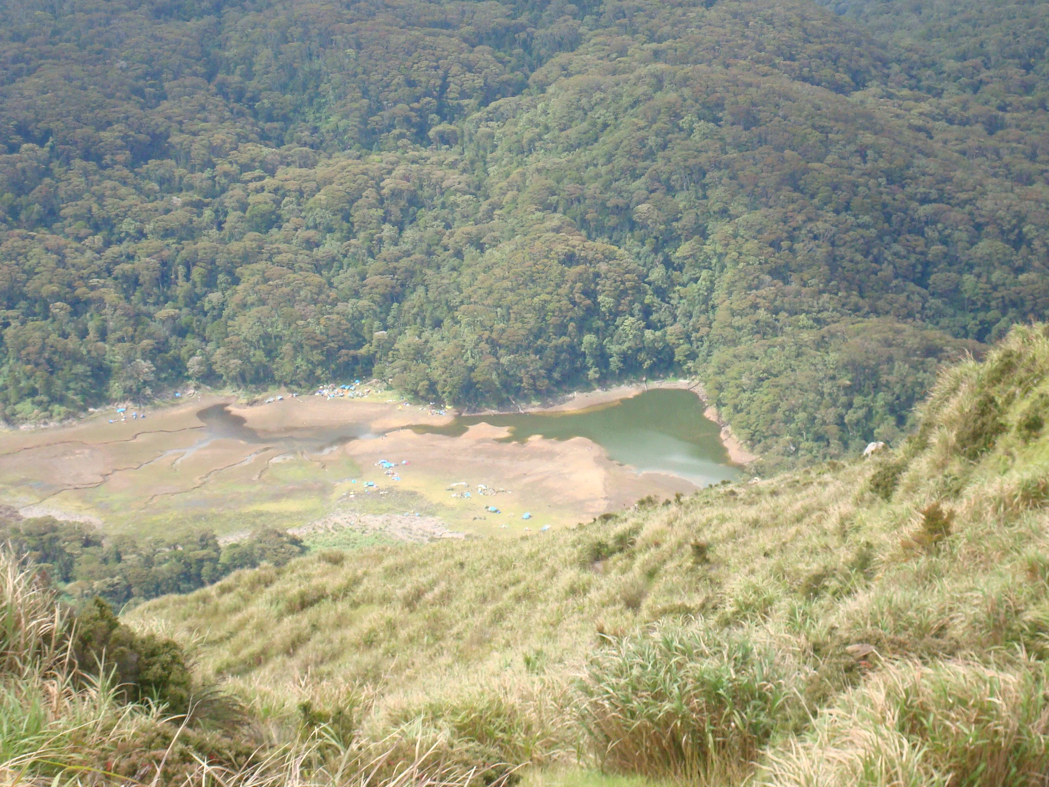
An elevated, wide view looking down at a greenish, irregularly shaped lake surrounded by mudflats and a dense, dark green forest on the slopes of a mountain.
A high vantage view of Lake Venado, a seasonal body of water located within Mount Apo Natural Park.

Mount Apo Natural Park history and protected-area timeline

Mount Apo Natural Park owes its protected status to a process that combined executive action and national legislation in the 1990s and early 2000s. A presidential proclamation in 1996 laid the legal foundation for recognizing the Mount Apo area as a national natural conservation site, and this was followed in 2004 by national legislation that formally ratified the area's status as a natural park. Together these measures moved Mount Apo from a regionally important protected landscape into an officially designated component of the Philippine protected area system.

Even before its formal designation as a natural park, Mount Apo had been recognized at the regional level. Since 1984, the area has been listed among natural heritage parks shared by ASEAN member states, placing it within a broader conservation network across Southeast Asia. This earlier recognition reflected both the mountain's ecological importance and its standing as a landmark landscape in Mindanao, and it helped set the stage for the subsequent national-level protection of the park.

Mount Apo Natural Park landscape and geographic character

The landscape of Mount Apo Natural Park is dominated by the volcanic massif of Mount Apo, the highest peak in the Philippines, which rises to nearly 2,954 meters above sea level. From its summit, the terrain descends into a steep and varied mountain environment shaped by elevation, volcanic history, and heavy rainfall. The result is a compressed sequence of vegetation zones, ranging from relatively dry, open summit vegetation and high-elevation grasslands through mossy montane forest down into dense tropical rainforest in the foothills.

Within the park, distinct landscape features include Lake Venado, a high-elevation lake situated in the upper mountain basin, as well as volcanic ridges, deep river valleys, and forested slopes. Water plays a significant role in shaping the park's scenery, with notable waterfalls and natural hot springs scattered across the protected area. The combination of summit terrain, deep forest cover, erosional features, and water systems gives the park a landscape profile that is both visually dramatic and ecologically layered, offering a clear illustration of how elevation influences tropical mountain environments in Mindanao.

Mount Apo Natural Park ecosystems, habitats, and plant life

Mount Apo Natural Park functions as one of the most ecologically important montane protected areas in the Philippines. Its substantial altitudinal range creates conditions for multiple vegetation communities to coexist within a relatively compact area, supporting more than 800 recorded plant species across tropical, montane, and high-elevation zones. The park's flora includes endemic genera and species that are restricted to Mindanao, alongside economically, medicinally, and culturally significant plants that are documented as part of local biodiversity inventories.

Forest cover is the defining ecological feature of the park across most of its elevation gradient, with lowland rainforest transitioning upward into montane and mossy forests. The park's vegetation holds particular conservation value because several of its endemic plant species are considered threatened and because the altitudinal sequencing of habitats supports specialized communities at higher elevations, including areas of stunted trees and shrubland near the summit. This combination of rich plant diversity and vegetation zonation reinforces the park's role as a key biodiversity area within Mindanao and within the broader Philippine protected area system.

Mount Apo Natural Park wildlife and species highlights

The wildlife of Mount Apo Natural Park reflects the ecological richness of Mindanao's montane forests. More than 270 bird species have been recorded in the area, including a particularly large share of Philippine endemics, with several threatened species among them. The park is also home to a notable diversity of mammals, with more than 50 known species, including several Philippine endemics such as tarsiers, Philippine warty pigs, and deer species that depend on intact forest cover.

The park's herpetofauna includes numerous amphibian and reptile species, a substantial portion of which are restricted to Mindanao. This combination of high endemism across birds, mammals, and herpetofauna positions Mount Apo Natural Park as an important site for the conservation of species that occur nowhere else, and it underscores the importance of protecting the full elevation range of the mountain rather than focusing solely on its summit areas.

Mount Apo Natural Park conservation status and protection priorities

Mount Apo Natural Park holds a central position in biodiversity conservation in Mindanao and the Philippines more broadly. The park is officially recognized as a key biodiversity area for the protection of Philippine endemic species, and its core and buffer zone structure supports conservation of forest cover, watershed functions, and habitat continuity across an altitudinal gradient that is unusually compressed within the national protected area system. The park's designation reflects ecological priorities, including the preservation of endemic plant and animal species and the maintenance of high-elevation habitats that are vulnerable to disturbance.

At the regional level, Mount Apo has been part of the shared network of natural heritage parks among ASEAN member states since the 1980s, situating its conservation role within a broader Southeast Asian framework. The park's protective framework combines national legislation, presidential proclamation, and international recognition, and it works alongside watershed protection goals that are particularly important given the role of Mount Apo's forests in supplying water to surrounding lowland communities.

Mount Apo Natural Park cultural meaning and human context

Mount Apo Natural Park holds significant cultural meaning for the indigenous communities whose traditional territories encompass parts of the protected area. Six indigenous groups, including the Manobos, Bagobos, Ubos, Atas, K'Iagans, and Tagacaolos, regard Mount Apo and its surrounding landscape as sacred land. The cultural importance of the mountain is intertwined with the area's identity as a protected natural park, and conservation planning in the region has historically needed to balance biodiversity objectives with respect for traditional cultural associations with the mountain.

Outside indigenous cultural contexts, Mount Apo also holds a prominent place in Philippine mountaineering and outdoor recreation traditions. Climbers and nature visitors are drawn to the mountain from across the Philippines, and the surrounding park has become a recognizable destination for those interested in tropical mountain trekking, high-elevation lakes, waterfalls, and natural hot springs. This blend of indigenous sacred geography and broader outdoor recreation culture gives Mount Apo Natural Park a layered cultural profile that extends well beyond its ecological role.

Top sights and standout views in Mount Apo Natural Park

A defining highlight of Mount Apo Natural Park is its protection of Mount Apo, the highest peak in the Philippines, which anchors a rare altitudinal sequence of tropical, montane, and high-elevation vegetation within a single protected boundary. The park stands out for the unusually high concentration of Mindanao-endemic species across plants, birds, mammals, and herpetofauna, making it one of the most significant biodiversity areas in the southern Philippines. Equally notable is its dual recognition as both a national natural park and a regional natural heritage site shared across Southeast Asia, which reflects its importance in wider conservation networks.

Visitors and researchers value the park for its combination of summit-scale scenery, Lake Venado in the high mountain basin, cascading waterfalls, and natural hot springs, all set within extensive forest cover. The cultural depth of the protected area, where indigenous communities regard Mount Apo as sacred land, adds a meaningful human dimension to an otherwise ecologically focused landscape and reinforces its standing as a destination where biodiversity and cultural heritage intersect.

Best time to visit Mount Apo Natural Park

Because Mount Apo Natural Park lies in the tropical climate of Mindanao, the year-round conditions are dominated by warmth and humidity, but the relative dryness of certain months offers the most stable window for summit climbs, ridge trekking, and waterfall visits. Cooler high-elevation conditions near the summit mean that even during warmer lowland periods, mountain temperatures remain significantly lower, with mist and sudden rainfall common in the upper zones.

Climbers and naturalists generally favor months associated with calmer weather, when trails to Mount Apo's summit and to Lake Venado are less affected by heavy rains and reduced visibility. Outside of these relatively drier months, the park still supports lower-elevation exploration of waterfalls and forest trails, though summit conditions and weather patterns can change quickly. The park's climatic range, from hot lowland valleys to cool high-elevation zones, means that seasonal timing tends to matter most for visitors planning to reach Mount Apo's summit rather than for those exploring the lower portions of the protected area.

Monthly climate preview

Long-term temperature and precipitation patterns from representative coordinates

Mount Apo Natural Park Climate Normals and Measured Weather by Month

Representative baseline data reveals consistent monthly temperature ranges and shifting precipitation rates across the sampled coordinate. Examining the complete twelve-month climate profile provides detailed numerical context for long-term meteorological patterns.
Annual mean25 °C
25 °C26 °C
Jan25°
Feb25°
Mar25°
Apr26°
May26°
Jun25°
Jul25°
Aug25°
Sep25°
Oct25°
Nov25°
Dec25°
Warmest month
April

26.3 °C

Coolest month
January

24.6 °C

Wettest month
June

7.5 mm/day

Driest month
February

3.2 mm/day

Park location guide

Geography guide, regional context, and park location map for Mount Apo Natural Park

Mount Apo Natural Park park geography, regions, and map view in Philippines

Understand where Mount Apo Natural Park sits in Philippines through a broader geographic reading of the surrounding landscape, nearby location context, and its mapped position within the national park landscape.

How Mount Apo Natural Park fits into Philippines

The Philippines, officially the Republic of the Philippines, is an archipelagic nation in Southeast Asia comprising approximately 7,641 islands categorized into three main geographical divisions: Luzon, Visayas, and Mindanao. Located in the western Pacific Ocean, it shares maritime borders with Taiwan, Japan, Palau, Indonesia, Malaysia, Vietnam, and China. Manila serves as the capital city, while Quezon City is the most populated city, both within Metro Manila.

Wider geography shaping Mount Apo Natural Park in Philippines

The Philippines is an archipelagic nation in Southeast Asia, positioned in the western Pacific Ocean. Its islands are bounded by the South China Sea to the west, Philippine Sea to the east, and Celebes Sea to the south. The country shares maritime borders with Taiwan to the north, Japan to the northeast, Palau to the east and southeast, Indonesia to the south, Malaysia to the southwest, Vietnam to the west, and China to the northwest.

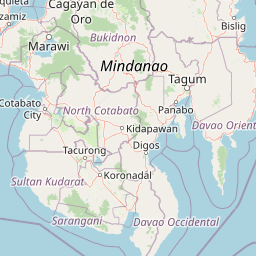
Map view of Mount Apo Natural Park

Use this park location map to pinpoint Mount Apo Natural Park in Philippines, understand its exact geographic position, and read its mapped placement within the surrounding landscape more clearly.

Pigeon | © OpenStreetMap contributors
Recorded earthquake history

Explore the Documented Earthquake History for Mount Apo Natural Park

Consult the historical seismic catalogue for Mount Apo Natural Park to review recorded earthquake data near this Mindanao landscape. This archive, powered by MoriAtlas, organizes documented seismic events by their proximity to the park, providing a clear reference for researchers and regional geography enthusiasts.

Mount Apo Natural Park Earthquake History

Catalogued events

302 events

Strongest magnitude

Magnitude 6.8

Most recent event

Apr 7, 2026

This history includes earthquakes recorded inside the park or within 50 km of its borders

Visualizing the volcanic terrain, montane forests, and high-elevation habitats of the Philippines

Mount Apo Natural Park Photos and Landscape Scenery

Examinations of Mount Apo Natural Park photos reveal the dramatic altitudinal zonation spanning from dense tropical rainforest to the highest volcanic summit in the Philippines. Visualizing these protected landscapes clarifies how montane forests, high-elevation lakes, and rugged terrain define the ecological character of Mindanao.

An elevated, wide view looking down at a greenish, irregularly shaped lake surrounded by mudflats and a dense, dark green forest on the slopes of a mountain.

The peak of Mount Apo rising above a blanket of clouds, viewed over a foreground of pine trees and a bright red flower.

Park atlas

Compare regional mountain geography and connected protected landscapes in Mindanao

Other Parks Like Mount Apo Natural Park And Nearby Protected Areas To Compare

Browsing other parks near Mount Apo Natural Park reveals broader ecological corridors and varied volcanic terrain across the southern Philippines. Expanding the geographic comparison provides useful context for understanding regional biodiversity patterns and protected mountain reserves.
A horizontal watercolor painting showing a calm lake in the foreground with lush green hills and distant mountain ridgelines in the background.
Protected areaMaguindanao del Sur
About 48 km away#1 closest

Southwest

Lake Buluan Protected Area: An Atlas Guide to Mindanao Lowland Freshwater Landscapes

Geography and hydrological map of the Maguindanao del Sur wetlands.

Lake Buluan represents a vast, shallow freshwater system known for its extensive marshes and role as a central basin for multiple Mindanao river tributaries. As a protected landscape in Maguindanao del Sur, it offers a distinct look at lowland hydrological patterns, floodplain dynamics, and the cultural history associated with the region's inland water resources.

Area
61.34 km²
Relief
Lowland
Water
Water-dominated
Marine protected areaDavao Oriental
About 90 km away#2 closest

East

Pujada Bay Protected Seascape: Marine Protected Area and Coastal Landscape in Davao Oriental

Coastal geography and protected marine ecosystems of Mindanao

Pujada Bay Protected Seascape serves as a primary coastal sanctuary along the Davao Oriental shoreline. Defined by the convergence of mountain-fed rivers, mangrove forests, and coral reef habitats within a semi-enclosed bay, this protected area offers a deep look into the marine geography of the Philippine archipelago.

Area
212 km²
Established
1994
Relief
Mixed relief
Access
Access unknown
A watercolor painting showing a soft, peaceful scene with green rolling hills, a calm bay or river in the foreground, and a pale pink and yellow sky.
National parkSarangani
About 94 km away#3 closest

South

Sarangani Bay National Park: Regional Geography and Protected Seascape Atlas

Coastal landscapes and maritime boundaries in southern Mindanao

Sarangani Bay represents a unique intersection of heavy maritime commerce and formal protected-area status. Stretching across the southern coastline of Mindanao, the bay provides a vital anchor for regional geography and ecological oversight. Examine the mapped extent, coastal municipalities, and the integration of this expansive marine environment into the national protected-area system.

Established
2018
Relief
Lowland
Scope
Marine
Water
Water-dominated
National parkMaguindanao del Norte
About 96 km away#4 closest

West

Mado Hot Spring National Park: Protected Geothermal Landscape in Maguindanao del Norte

Explore its therapeutic hot springs and mapped boundaries

Mado Hot Spring National Park, located in Maguindanao del Norte, Philippines, is a protected area defined by its geothermal features and therapeutic hot springs. This national park, established early in the Philippines' conservation history, offers a unique landscape centered around a warm mineral-rich natural pool. Delve into the geographic context and protected area identity of this distinctive site, understanding its role within the region's natural heritage.

Area
0.48 km²
Established
1939
IUCN
II
Scope
Terrestrial
National parkLanao del Sur
About 119 km away#5 closest

Northwest

Rungkunan National Park: Mapped Protected Landscape and Regional Geography Overview

Discover Rungkunan National Park's protected boundaries and landscape context.

Gain insight into Rungkunan National Park, a protected national park situated in Lanao del Sur. This page details the park's geographic positioning, mapped outlines, and its significance as a conservation landscape. It provides essential context for understanding the distribution of protected areas and the regional geography of the Philippines, facilitating a deeper atlas-style exploration.

Established
1965
IUCN
V
Water
Minor water
National parkLanao del Sur
About 120 km away#6 closest

Northwest

Salikata National Park: Explore Philippines National Park Geography

Mapped protected area boundaries and regional context.

Investigate Salikata National Park, a key protected area designated as a national park within Lanao del Sur, Philippines. This detailed view provides essential context for understanding its mapped boundaries, its place in the regional geography, and its significance as a protected landscape. Discover the unique geographic attributes that define Salikata National Park for atlas-based exploration.

Established
1965
IUCN
V
Relief
Mountain
Climate
Tropical
National parkLanao del Sur
About 131 km away#7 closest

Northwest

Lake Butig National Park: National Park Atlas and Geographic Discovery in Lanao del Sur

Discover its mapped boundaries and regional landscape context.

Lake Butig National Park is a protected national park in the Philippines, located within Lanao del Sur. This entry provides specific geographic information and supports atlas exploration by detailing the park's mapped boundaries and its place within the regional landscape. Understand the terrain and protected area context crucial for geographic study and understanding Philippine natural landscapes.

Area
0.68 km²
Established
1965
IUCN
V
Relief
Mountain
National parkLanao del Sur
About 131 km away#8 closest

Northwest

Pantuwaraya Lake National Park: National Park Atlas and Mapped Landscape

Explore the protected area and regional geography of Lanao del Sur.

Understand Pantuwaraya Lake National Park as a defined protected landscape and a significant national park within the Philippines. This entry focuses on its geographic placement in Lanao del Sur, providing context for its mapped boundaries and natural features. Users can explore its representation within a broader atlas of protected lands, gaining insight into its role and landscape identity.

Area
0.2 km²
Established
1965
IUCN
V
Climate
Tropical

Common questions about visiting, size, designation, and location context for Mount Apo Natural Park

Mount Apo Natural Park FAQs for park facts, access, geography, and protected area context

Find quick answers about Mount Apo Natural Park, including protected-area facts, park geography, trail and visitor context, and how the park fits into its surrounding country and regional landscape.
MoriAtlas Explorer

Continue Your Protected Areas Search Across the Global Atlas

Deepen your exploration by continuing the structured search for national parks and protected areas worldwide. Utilize the comprehensive filtering capabilities to compare different conservation landscapes and refine your understanding of global park geography. Discover more about the distribution and characteristics of protected natural areas.

Global natural geography