

Mori Atlas logo
National parkMount Guiting-Guiting Natural Park

A critical mountain massif and forest reserve located within the Province of Romblon

Mount Guiting-Guiting Natural Park: Exploring Protected Rainforest Landscapes and Island Geography

Mount Guiting-Guiting Natural Park safeguards the steep, forest-covered slopes of the highest peak in the Province of Romblon. Rising from the interior of Sibuyan Island, this protected area features expansive, dense tropical rainforest and rugged montane terrain. The geography of the park serves as a vital island-based watershed and habitat, illustrating the distinct ecological isolation found across the central Philippine archipelago.

tropical rainforestisland parkmountain parkRomblonSibuyan IslandMimaropa

Mount Guiting-Guiting Natural Park

National park

Park overview

Structured park overview, official facts, and landscape profile for Mount Guiting-Guiting Natural Park

Mount Guiting-Guiting Natural Park park facts, protected area profile, and essential visitor context

Review the core facts for Mount Guiting-Guiting Natural Park, including designation, size, terrain, visitor scale, habitats, and operating context in one park-focused overview.

About Mount Guiting-Guiting Natural Park

Mount Guiting-Guiting Natural Park is a protected natural area situated on Sibuyan Island, one of the larger islands in Romblon province in the central Philippines. The park's defining feature is its coverage of Mount Guiting-Guiting, which at roughly 1,732 meters is the highest peak in Romblon and a notable high point of the Sibuyan landscape. The protected designation extends across forested slopes and adjacent terrain, anchoring the island's upland ecological zone.

The park sits within a tropical island setting where steep terrain meets dense vegetation, and the surrounding land cover is characterized by extensive forest. Because Sibuyan is a relatively remote island without easy mainland access, the park area has retained a strong forest character. This makes the natural park a meaningful refuge for tropical biodiversity, even though it occupies only a portion of the broader island.

Administratively, the park falls within the municipality of San Fernando in the Province of Romblon, part of the Mimaropa region of the Philippines. Its position between the island's communities, agricultural lowlands, and the forested upper slopes gives it both an ecological role as a watershed and biodiversity reserve and a geographic role as a defining feature of the Sibuyan landscape. Climatically, the area receives substantial rainfall year-round, supporting the rich rainforest vegetation that defines the park's identity.

Quick facts and research context for Mount Guiting-Guiting Natural Park

Mount Guiting-Guiting Natural Park lies on Sibuyan Island in the Province of Romblon, Mimaropa region, Philippines, within the municipality of San Fernando. The park encompasses the slopes of Mount Guiting-Guiting, which reaches approximately 1,732 meters in elevation and is the highest point in Romblon province. The protected area sits roughly 300 kilometers southeast of Manila and falls within the Philippine Standard Time zone.

Park context

Deeper park guide and search-rich context for Mount Guiting-Guiting Natural Park

Mount Guiting-Guiting Natural Park history, landscape, wildlife, and travel context

Explore Mount Guiting-Guiting Natural Park through its history, landscape character, ecosystems, wildlife, conservation priorities, cultural context, and seasonal travel timing in a structured park guide built for atlas discovery and search intent.

Why Mount Guiting-Guiting Natural Park stands out

Mount Guiting-Guiting Natural Park is best known for protecting the densely forested slopes of Mount Guiting-Guiting, the tallest mountain in Romblon province, on the relatively isolated island of Sibuyan. The park is recognized as a strong example of Philippine tropical lowland and montane rainforest, set within an island geography that limits disturbance and helps preserve its forest cover.

Mount Guiting-Guiting Natural Park landscape and geographic character

The landscape of Mount Guiting-Guiting Natural Park is shaped by the central massif of Mount Guiting-Guiting, a steep mountain that rises from the interior of Sibuyan Island to about 1,732 meters above sea level. The park's terrain follows the gradient from lower forested foothills up through increasingly rugged mid-elevation slopes toward the higher elevations of the peak.

Dense tropical rainforest covers much of the park, with the surrounding area dominated by closed-canopy forest rather than open land. Because Sibuyan is an island, the park's scenery is framed by the contrast between this elevated, forested interior and the surrounding seascape, where slopes eventually descend to coastal lowlands and small island communities.

Mount Guiting-Guiting Natural Park ecosystems, habitats, and plant life

The park's natural environment is defined by tropical rainforest that blankets the slopes of Mount Guiting-Guiting. This forest cover is the park's primary ecological feature, forming a continuous green landscape across the mountain's gradient from lower elevations to the higher slopes. The heavy forestation reflects the area's tropical climate and consistent rainfall.

As an island-based upland forest reserve, the park contributes meaningfully to the regional forest mosaic of Romblon. Its continuous cover of natural vegetation provides habitat continuity across elevation zones, supporting ecological processes that depend on intact forest landscapes rather than fragmented patches.

Mount Guiting-Guiting Natural Park conservation status and protection priorities

Mount Guiting-Guiting Natural Park represents a conservation effort to safeguard the forested slopes of one of Romblon's most significant mountains, preserving a continuous block of tropical rainforest on Sibuyan Island. By protecting this upland ecosystem, the park helps maintain a forest refuge within an island setting where the surrounding geography consists largely of coastal and lowland areas.

The protected status of the park also has practical value in maintaining the forested watershed that feeds the rivers and streams descending from Mount Guiting-Guiting. In regional conservation terms, the park strengthens the network of natural forest areas remaining across the smaller islands of the central Philippines.

Top sights and standout views in Mount Guiting-Guiting Natural Park

The park's standout quality is the protection of an entire forested mountain on a single Philippine island, offering a rare example of contiguous rainforest in Romblon province. Mount Guiting-Guiting's elevation, its position as Romblon's highest peak, and the deep forest cover that surrounds it combine to make the park a defining natural feature of Sibuyan Island.

Best time to visit Mount Guiting-Guiting Natural Park

The park's tropical climate means warm temperatures year-round, with generally cooler conditions at higher elevations along the slopes of Mount Guiting-Guiting. Like much of the Philippines, the region experiences pronounced wet and drier periods, and rainforest conditions mean visitors should generally anticipate humid weather, lush vegetation, and the possibility of rainfall during much of the year. Travelers interested in clearer conditions may favor the drier months, while those interested in the most verdant rainforest scenery may favor wetter periods.

Monthly climate preview

Long-term temperature ranges and monthly precipitation recorded at representative coordinates

Mount Guiting-Guiting Natural Park Climate Normals and Annual Weather Patterns

Representative coordinate records show measured temperature variations and monthly precipitation amounts across the year for Mount Guiting-Guiting Natural Park. Examining the complete twelve-month climate profile reveals detailed long-term averages for thermal and precipitation behavior.
Annual mean27 °C
26 °C29 °C
Jan26°
Feb26°
Mar27°
Apr28°
May29°
Jun28°
Jul28°
Aug28°
Sep28°
Oct28°
Nov28°
Dec27°
Warmest month
May

28.9 °C

Coolest month
January

26 °C

Wettest month
December

10.2 mm/day

Driest month
April

2.5 mm/day

Park location guide

Geography guide, regional context, and park location map for Mount Guiting-Guiting Natural Park

Mount Guiting-Guiting Natural Park park geography, regions, and map view in Philippines

Understand where Mount Guiting-Guiting Natural Park sits in Philippines through a broader geographic reading of the surrounding landscape, nearby location context, and its mapped position within the national park landscape.

How Mount Guiting-Guiting Natural Park fits into Philippines

The Philippines, officially the Republic of the Philippines, is an archipelagic nation in Southeast Asia comprising approximately 7,641 islands categorized into three main geographical divisions: Luzon, Visayas, and Mindanao. Located in the western Pacific Ocean, it shares maritime borders with Taiwan, Japan, Palau, Indonesia, Malaysia, Vietnam, and China. Manila serves as the capital city, while Quezon City is the most populated city, both within Metro Manila.

Wider geography shaping Mount Guiting-Guiting Natural Park in Philippines

The Philippines is an archipelagic nation in Southeast Asia, positioned in the western Pacific Ocean. Its islands are bounded by the South China Sea to the west, Philippine Sea to the east, and Celebes Sea to the south. The country shares maritime borders with Taiwan to the north, Japan to the northeast, Palau to the east and southeast, Indonesia to the south, Malaysia to the southwest, Vietnam to the west, and China to the northwest.

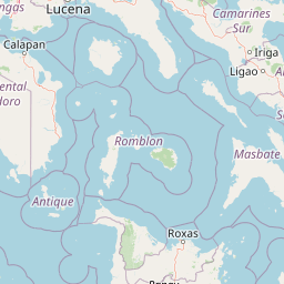
Map view of Mount Guiting-Guiting Natural Park

Use this park location map to pinpoint Mount Guiting-Guiting Natural Park in Philippines, understand its exact geographic position, and read its mapped placement within the surrounding landscape more clearly.

Pigeon | © OpenStreetMap contributors

Location context for Mount Guiting-Guiting Natural Park

MimaropaProvince of Romblon
Park atlas

Compare nearby regional reserves and connected island conservation landscapes

Parks Near Mount Guiting-Guiting Natural Park and Surrounding Protected Areas

Browsing other parks near Mount Guiting-Guiting Natural Park reveals broader regional geography across the surrounding island ecosystems. Expanding the search helps connect isolated forest reserves and protected mountain terrain into a comprehensive geographic overview.
Wildlife reserveQuezon
About 105 km away#1 closest

North

Mulanay Watershed Forest Reserve: Mapping Protected Lowland Rainforests in Quezon

A watershed conservation site on the Bondoc Peninsula

Spanning 474 hectares in the province of Quezon, the Mulanay Watershed Forest Reserve acts as a protected anchor for local biodiversity and hydrological health. The reserve preserves rolling, forest-covered hills that feed the Cawayan Creek, illustrating the importance of small, strategically managed protected lands within the larger Philippine conservation framework.

Area
4.74 km²
Established
1938
Relief
Upland
Water
Minor water
A horizontal watercolor painting of a mangrove forest with green canopies and characteristic prop roots rising from calm, reflective mudflats against a white background.
Protected landscapeCalabarzon
About 106 km away#2 closest

North

Alibijaban Protected Landscape and Seascape: Coastal and Marine Geography

A protected island refuge in the Ragay Gulf of Calabarzon

The Alibijaban Protected Landscape and Seascape is a significant conservation site known for its undisturbed mangrove interior and thriving coral reef ecosystems. Its geography features flat terrain, sandy beaches, and complex seagrass meadows that attract diverse wildlife. This map-based overview provides detailed insights into the protected island's physical boundaries and unique marine-terrestrial intersection.

Area
10.56 km²
Established
1981
Relief
Lowland
Climate
Tropical
Wildlife reserveMarinduque
About 131 km away#3 closest

Northwest

Marinduque Wildlife Sanctuary: Map of the Protected Interior Forest

Exploring the essential wildlife habitats of Marinduque Island

Spanning 8,800 hectares of hilly terrain across five municipalities, the Marinduque Wildlife Sanctuary protects a critical block of forest. This reserve is recognized as a vital sanctuary for endemic Philippine species and forms a significant ecological backbone within the heart of the island landscape.

Area
88.28 km²
Established
2004
Relief
Mountain
Climate
Tropical
National parkPhilippines
About 148 km away#4 closest

North

Libmanan Caves National Park: Philippines National Park and Mapped Landscape

Explore protected area boundaries and regional geography.

Libmanan Caves National Park is a protected national park within the Philippines, offering a distinct focus for geographic discovery. This entry provides detailed context on its mapped landscape and its place within the archipelago's protected areas. Users can gain a clear understanding of the park's regional setting, facilitating atlas-style exploration and comprehension of its conservation significance within the Philippine geography.

Area
0.194 km²
Established
1934
IUCN
III
Relief
Upland
National parkPhilippines
About 156 km away#5 closest

South

Bulabog Putian National Park: Philippines National Park Geographic Context and Mapped Boundaries

Discover the protected landscape identity and regional atlas significance.

Bulabog Putian National Park stands as a designated national park in the Philippines, offering valuable insights for geographic and protected-area exploration. Users can understand its specific location and mapped presence within the country's natural landscape, contributing to a structured atlas of conservation areas. This entry focuses on the park's identity and geographic setting for informed discovery.

Area
8.543 km²
Established
1961
IUCN
V
Relief
Mountain
National parkMindoro
About 157 km away#6 closest

West

Mounts Iglit, Baco National Park: Philippines Protected Landscape and Geographic Identity

Explore Mindoro's significant national park and its mapped natural terrain.

Delve into Mounts Iglit, Baco National Park, a protected national park located on the island of Mindoro. This entry offers a detailed geographic perspective, focusing on its mapped boundaries and its role within the archipelago's conservation landscape. Understand the park's specific regional geography and its identity as a distinct protected area.

Relief
Mountain
Scope
Terrestrial
National parkPhilippines
About 159 km away#7 closest

Northwest

Naujan Lake National Park: Philippines National Park Atlas and Protected Landscape

Explore its mapped boundaries and regional geographic context.

Naujan Lake National Park offers a focused exploration of a distinct protected landscape within the Philippines. This page details the park's specific geographic footprint and its characteristics as a national park. Understand its place within the archipelago's broader geography, providing a valuable entry point for atlas-based discovery of protected natural areas and their mapped extents across Southeast Asia.

Scope
Terrestrial
Water
Water-dominated
National parkCamarines Sur
About 163 km away#8 closest

Northeast

Mount Isarog National Park: Exploring the Volcanic Geography and Forested Slopes of Camarines Sur

Mapping the altitudinal zonation of a significant Luzon stratovolcano

Mount Isarog National Park defines the natural profile of southeastern Luzon. This protected area preserves a full volcanic stratigraphy, ranging from tropical lowland rainforest to stunted mossy summit forests. The park is characterized by its steep ravines, drainage channels, and globally recognized biological endemism, providing a clear example of altitudinal compression within a single mountain ecosystem in the Philippines.

Area
99.71 km²
Established
1938
Relief
Mountain
Climate
Tropical

Common questions about visiting, size, designation, and location context for Mount Guiting-Guiting Natural Park

Mount Guiting-Guiting Natural Park FAQs for park facts, access, geography, and protected area context

Find quick answers about Mount Guiting-Guiting Natural Park, including protected-area facts, park geography, trail and visitor context, and how the park fits into its surrounding country and regional landscape.
MoriAtlas Explorer

Continue Your Protected Areas Search Across the Global Atlas

Deepen your exploration by continuing the structured search for national parks and protected areas worldwide. Utilize the comprehensive filtering capabilities to compare different conservation landscapes and refine your understanding of global park geography. Discover more about the distribution and characteristics of protected natural areas.

Global natural geography