
Mori Atlas logo
Wildlife reserveMount Hood Wilderness

Analyzing the glacial formations and ecosystem gradients across Oregon's premier mountain sanctuary

Mount Hood Wilderness: A Detailed Geographic Atlas of Volcanic Terrain and Protected Landscapes

The Mount Hood Wilderness encompasses roughly 65,000 acres of protected land centered on the iconic volcanic cone of Mount Hood. This geographic domain preserves a complete vertical gradient of Pacific Northwest ecosystems, from mossy lowland temperate rainforests and old growth forest stands up through subalpine meadows to barren, ice-carved ridges. Beyond the summit, the mapped terrain features deeply incised basaltic canyons and active glacial basins that demonstrate the complex interaction between stratovolcano construction and glacial erosion in the Cascade Range.

wilderness areaCascade Rangevolcanic landscapealpine meadowstemperate rainforestglaciers
A stylized digital illustration of a mountainous landscape with a waterfall flowing down a cliff, a winding river, evergreen forests, and a rocky foreground under a soft sunset sky.

Mount Hood Wilderness

Wildlife reserve

Park overview

Structured park overview, official facts, and landscape profile for Mount Hood Wilderness

Mount Hood Wilderness park facts, protected area profile, and essential visitor context

Review the core facts for Mount Hood Wilderness, including designation, size, terrain, visitor scale, habitats, and operating context in one park-focused overview.

About Mount Hood Wilderness

The Mount Hood Wilderness sits within the Mount Hood National Forest, occupying the heart of Oregon's Cascade Range about an hour east of Portland. The wilderness follows the contours of Mount Hood itself, encircling the upper mountain and capturing the transition zones where Cascade forests give way to glaciated volcanic terrain.

The landscape is defined by steep vertical change. Lower elevations along the western and southern edges of the wilderness support dense temperate rainforests characteristic of the western Cascades, with hemlock, Douglas fir, and cedar stands watered by heavy seasonal precipitation. Mid elevations transition into drier, more open montane forests before giving way to subalpine parkland and finally to barren slopes of lava, scree, and ice near the summit. Prominent features within the wilderness include Barrett Spur on the mountain's northern flank, the deep glacial valleys that radiate outward from the peak, and well-known locations such as Elk Cove near the tree line on the north side.

The wilderness is closely intertwined with Oregon's outdoor recreation identity. Free wilderness permits are required for entry, but the area remains highly accessible due to its proximity to major highways, Forest Service roads, ski area parking, and trailheads such as those near Lolo Pass and Cloud Cap. The Timberline Trail, one of the most recognizable loop hikes in the Pacific Northwest, traces a 41-mile route around the mountain within the wilderness, sharing a section with the longer Pacific Crest Trail. The result is a working wilderness that simultaneously functions as a strict preservation landscape, a training ground for climbers, and a popular hiking and backpacking destination.

Quick facts and research context for Mount Hood Wilderness

The Mount Hood Wilderness is a Wilderness Area managed by the U.S. Forest Service within the Mount Hood National Forest in northern Oregon. Established in 1964, it covers approximately 64,742 acres and spans both Clackamas and Hood River counties.

Its boundaries encircle Mount Hood, Oregon's highest peak, extending from temperate rainforest valleys up through subalpine zones to glaciated summit ridges near 11,000 feet. The wilderness borders both the Timberline Lodge ski area and the Mount Hood Meadows resort on the mountain's south and east flanks. It is part of the broader National Wilderness Preservation System, which protects landscapes from roads, logging, mining, and permanent structures.

Protection and recognition

Documented terrestrial protection scope and management records for Mount Hood Wilderness

Mount Hood Wilderness Protection Status and Official Designation Records

Mount Hood Wilderness maintains a documented terrestrial protection scope detailing management parameters and administrative boundaries. Official conservation records catalog the designated status and international recognition frameworks associated with the protected landscape.

Protection details

Protection scope
Terrestrial
Transboundary protection
No
Park context

Deeper park guide and search-rich context for Mount Hood Wilderness

Mount Hood Wilderness history, landscape, wildlife, and travel context

Explore Mount Hood Wilderness through its history, landscape character, ecosystems, wildlife, conservation priorities, cultural context, and seasonal travel timing in a structured park guide built for atlas discovery and search intent.

Why Mount Hood Wilderness stands out

The Mount Hood Wilderness is best known for compressing an unusually complete vertical range of Pacific Northwest ecosystems into a single protected area. In just a few miles of trail, visitors move from mossy lowland rainforests through montane forests and subalpine parkland into barren volcanic ridges carved by glaciers such as Ladd, Coe, and Eliot. The area is also famous for its climbing culture. Mount Hood's standard south-side route through the wilderness is one of the most attempted summit climbs in North America, drawing thousands of climbers each year. The Timberline Trail, the wilderness's signature long-distance route, ties together glaciers, meadows, waterfalls like Ramona Falls, and historic stone structures that predate the wilderness designation, making the area a defining example of high-elevation volcanic wilderness in the lower 48 states.
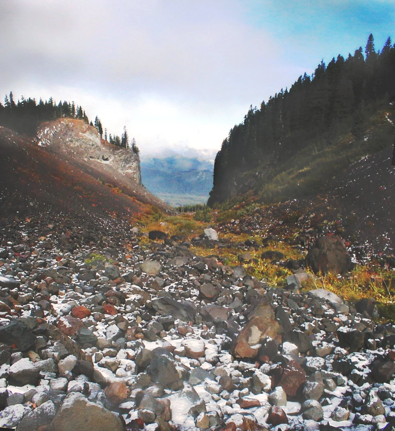
A low angle view of a rocky glacial valley with dark, steep slopes covered in volcanic rock and patches of snow, flanked by coniferous forests, leading toward a distant misty peak.
A glacial valley landscape featuring rocky slopes and coniferous forest within the Mount Hood Wilderness.

Mount Hood Wilderness history and protected-area timeline

The Mount Hood Wilderness was formally designated in 1964 as part of the initial wave of protections established by the federal Wilderness Act of that same year. Its designation came at a moment when the United States was moving away from a purely utilitarian view of National Forest lands and beginning to recognize certain areas as deserving of higher levels of protection from roads, logging, and development.

The wilderness was built on a landscape with a longer human story. Mount Hood had long been a focal point for indigenous peoples of the Columbia Plateau region, and by the early twentieth century it had become a destination for mountaineers drawn to its glaciers and prominent summit. Stone structures within the wilderness, including the remains of a lodge near Cairn Basin on the northwest side, predate the formal wilderness designation and reflect an earlier era of mountain recreation that included private cabins and rudimentary mountain travel infrastructure.

In the decades following designation, management has focused on balancing growing public use with the constraints of the Wilderness Act. Portions of the Timberline Trail, including stretches near the landslide-prone Eliot Branch near Cloud Cap, have been rerouted or temporarily closed due to natural hazards. Despite its proximity to ski developments on the south and east flanks, the wilderness itself remains free of motorized access, permanent structures, timber harvest, and mining, preserving the landscape as it was understood at the time of original designation.

Mount Hood Wilderness landscape and geographic character

The Mount Hood Wilderness is defined by the volcanic cone of Mount Hood, an active stratovolcano that towers over 11,000 feet and dominates the surrounding topography. The wilderness wraps the upper mountain from the west to the northeast, capturing a dramatic descent from glaciated summit ridges down through forested valleys to more moderate terrain along its lower margins.

Glacial sculpting is central to the area's character. U-shaped valleys carved by former ice flows radiate outward from the mountain, and active glaciers including Ladd, Coe, Eliot, and others continue to shape the upper basin. On the mountain's northern flank, features such as Barrett Spur stand as rocky divides between neighboring glaciers, illustrating the layered relationship between volcanic construction and glacial erosion that defines the Cascade Range. The wilderness also includes water-carved basaltic features such as Ramona Falls and a network of streams cutting down through lava and ash deposits.

Cliff bands, lava flows, and deeply incised canyons create a rugged interior landscape that contrasts with the older, more weathered terrain of the forest below. Above the tree line, the scenery shifts to exposed ridges, alpine meadows, and barren pumice slopes that change visibly from season to season. Elevations within the wilderness range roughly from below 3,000 feet in lower drainages to nearly 7,900 feet on prominent ridges like Barrett Spur, with the mountain's summit rising higher than the wilderness boundary itself in most directions.

Mount Hood Wilderness ecosystems, habitats, and plant life

Ecologically, the Mount Hood Wilderness captures an unusually complete cross section of Pacific Northwest environments. The lowest elevations are cloaked in temperate rainforests dominated by Douglas fir, western hemlock, and western red cedar, with dense understory of mosses, ferns, and salal reflecting the region's famously wet winters and mild summers. These forests are among the most ecologically productive temperate forests in the world, and the wilderness preserves extensive stands that approach old-growth character.

Moving upward, the forests thin and diversify as conditions become drier and more variable. Mid-elevation slopes include mixed conifer stands and open parkland, eventually giving way to subalpine fir and mountain hemlock near the tree line. The wilderness protects fragile alpine and subalpine meadows that take many decades to recover from trampling, which is why trail reroutes in the area have sometimes been motivated as much by meadow protection as by washouts or hazard.

Snowpacks and glacial melt sustain a network of streams, waterfalls, and wet meadows that anchor the area's hydrology and habitat structure. The combination of long winters, deep snow accumulation, and summer melt drives both the wilderness's seasonal ecology and its patterns of plant succession above the tree line.

Mount Hood Wilderness wildlife and species highlights

Wildlife in the Mount Hood Wilderness reflects the elevation gradient that defines the area. Lower forests support species typical of the western Cascades, including black bear, black-tailed deer, elk, mountain lion, and a wide range of small mammals. The wilderness's association with the elk of the Mount Hood region is well established; locations such as Elk Cove on the mountain's north side are named for the herds that historically used these high basins.

Birdlife spans forest, meadow, and alpine habitats. The dense conifer canopy shelters species such as northern spotted owls, pileated woodpeckers, and varied thrushes, while more open ridges and meadows provide habitat for Clark's nutcrackers, gray jays, and seasonal migrants. Peregrine falcons and other raptors use the cliff bands and rocky ridges of the upper mountain, where updrafts along the volcanic cone create productive hunting conditions.

Streams and cold, glacier-fed pools support native fish communities including trout and other salmonids characteristic of the Cascades. Because the wilderness prohibits motorized access and most forms of habitat disruption, it functions as a refuge for species that are sensitive to human pressure, particularly those tied to older forest structure and intact hydrological systems.

Mount Hood Wilderness conservation status and protection priorities

The Mount Hood Wilderness was established at the founding of the National Wilderness Preservation System, and its conservation significance derives from that legal framework. Under the 1964 Wilderness Act, the area is protected from roads, permanent structures, logging, and mining, and its boundaries were drawn to capture not only the mountain's summit but also the ecological transitions that give the Cascades their distinctive character.

Within the broader Mount Hood National Forest, the wilderness serves as the ecological anchor of the landscape. By keeping the upper mountain and its forested base free from intensive management, the designation helps maintain watershed function for downstream communities, preserves habitat for species dependent on mature and old-growth forest, and protects alpine and subalpine environments that are slow to recover from disturbance. The wilderness also plays a role in safeguarding scenic and recreational values that would otherwise be pressured by expanding infrastructure near the ski areas and highway corridors adjacent to its boundaries.

Management of the area is complicated by exceptionally heavy use. As the gateway to the most climbed snow peak in the United States, the wilderness faces sustained pressure from climbers, day hikers, and long-distance backpackers on routes such as the Timberline Trail. Conservation practice in the area reflects this tension, combining permit systems, trail reroutes, meadow protection measures, and educational signage to maintain the wilderness character of the landscape while accommodating continued public access.

Mount Hood Wilderness cultural meaning and human context

Mount Hood has long held significance for the indigenous peoples of the Columbia Plateau, including the Confederated Tribes of the Warm Springs and other nations of the region, who viewed the mountain as a defining feature of their homelands and incorporated it into traditional stories, seasonal travel, and resource use. The mountain's prominent silhouette has shaped regional identity in Oregon for generations.

In the non-indigenous era, Mount Hood became a focal point for Pacific Northwest mountaineering and outdoor recreation. Early stone structures within the wilderness, including the lodge remains near Cairn Basin, reflect a period of private recreational building that preceded stricter protection. The development of Timberline Lodge in the 1930s added an architectural and cultural landmark to the mountain's south side, while the long-standing presence of climbing clubs, Forest Service Rangers, and outdoor organizations has produced a layered outdoor culture around the wilderness that continues to influence Oregon's identity as a center of American mountaineering.

Top sights and standout views in Mount Hood Wilderness

The Timberline Trail stands out as the defining long-distance experience of the Mount Hood Wilderness, a 41-mile loop that circles the mountain and shares a section with the Pacific Crest Trail. It condenses almost every landscape type in the wilderness into a single route, from dense rainforests through basaltic canyons and alpine meadows to the edges of active glaciers.

The area's volcanic signature is unmistakable. Glaciers such as Ladd, Coe, and Eliot, dramatic ridges like Barrett Spur, and landmarks such as Ramona Falls and Elk Cove illustrate how volcanic processes and glacial erosion combine to shape the Cascades. Finally, the mountain's status as a training ground for climbers and a destination for Pacific Northwest hikers gives the wilderness a cultural prominence that few similarly sized protected areas in the contiguous United States can match.

Best time to visit Mount Hood Wilderness

Summer is the dominant season for most Mount Hood Wilderness visitors, when snow has largely melted from lower and mid-elevation trails and the Timberline Trail and other routes are typically at their most accessible. July through September generally offers the most stable conditions for backpacking, wildflower viewing in alpine meadows, and visits to destinations such as Ramona Falls and Elk Cove.

Late spring can extend the ski mountaineering and snow climbing season on Mount Hood's upper slopes, when the mountain's glaciers are still well covered but weather windows are more frequent than deep winter. Winter brings the heaviest snowpack and the most challenging trail conditions, with many lower trailheads buried under snow and access shifted toward the ski area base facilities. Climbers targeting the summit generally favor late spring through early summer, when consolidated snow bridges and reasonable weather combine with longer daylight to support a summit attempt.

Monthly climate preview

Long-term average temperature and precipitation patterns recorded across twelve monthly intervals.

Mount Hood Wilderness Climate Normals and Representative Monthly Temperature Rhythms

Representative coordinate measurements reveal how monthly mean temperatures and precipitation rates fluctuate across the protected area. Examining the full twelve-month dataset clarifies long-term climate normals and seasonal precipitation rhythms.
Annual mean8 °C
1 °C17 °C
Jan
Feb
Mar
Apr
May11°
Jun13°
Jul17°
Aug17°
Sep14°
Oct
Nov
Dec
Warmest month
August

17.5 °C

Coolest month
December

0.6 °C

Wettest month
December

7.7 mm/day

Driest month
July

0.5 mm/day

Park location guide

Geography guide, regional context, and park location map for Mount Hood Wilderness

Mount Hood Wilderness park geography, regions, and map view in United States of America

Understand where Mount Hood Wilderness sits in United States of America through a broader geographic reading of the surrounding landscape, nearby location context, and its mapped position within the national park landscape.

How Mount Hood Wilderness fits into United States of America

The United States of America is a federal presidential republic and one of the world's largest countries by area and population. It consists of 50 states across a vast territory spanning multiple time zones, with its capital in Washington, D.C. and largest city in New York City. The nation has a diverse economy, influential political system, and significant cultural and military presence globally.

Wider geography shaping Mount Hood Wilderness in United States of America

The United States occupies a vast territory in North America, bordered by Canada to the north and Mexico to the south. The 48 contiguous states stretch from the Atlantic to the Pacific Ocean, while Alaska occupies the northwestern region and Hawaii is an archipelago in the Pacific. The country encompasses diverse terrain including the Rocky Mountains, Appalachian Mountains, Great Plains, and extensive river systems.

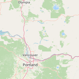
Map view of Mount Hood Wilderness

Use this park location map to pinpoint Mount Hood Wilderness in United States of America, understand its exact geographic position, and read its mapped placement within the surrounding landscape more clearly.

Pigeon | © OpenStreetMap contributors

Location context for Mount Hood Wilderness

Oregon
Natural feature types

Explore the Topographic and Natural Features of Mount Hood Wilderness

Deepen your geographic understanding of the Mount Hood Wilderness by browsing the distinct landmarks and natural systems mapped across its volcanic terrain. MoriAtlas provides a structured perspective on the glaciers, valleys, and ridges that define the physical character of this significant protected landscape.
Recorded earthquake history

Explore the Historical Earthquake Records for Mount Hood Wilderness

Access the structured catalogue of documented seismic events associated with Mount Hood Wilderness. This resource allows for clear review of recorded earthquake activity, providing geographic and historical context for events identified within the vicinity of the protected area.

Mount Hood Wilderness Earthquake History

Catalogued events

18 events

Strongest magnitude

Magnitude 4.5

Most recent event

Jun 6, 2021

This history includes earthquakes recorded inside the park or within 50 km of its borders

Explore protected-area photography documenting glaciated ridges, old-growth forests, and rugged alpine scenery.

Mount Hood Wilderness Photos and Scenery: Visualizing Volcanic Terrain and Alpine Habitats

High-resolution park photography captures the dramatic vertical range of temperate rainforests, basaltic canyons, and active glaciers across the protected landscape. Visualizing these shifting elevation gradients reveals the complex terrain and ecological character defining the regional environment.

A low angle view of a rocky glacial valley with dark, steep slopes covered in volcanic rock and patches of snow, flanked by coniferous forests, leading toward a distant misty peak.

A high angle shot of a rocky, rugged mountain ridge featuring patches of snow and evergreen forest coverage against a clear blue sky.

Park atlas

Compare surrounding regional geography and adjacent Pacific Northwest protected areas

Explore Other Parks Near Mount Hood Wilderness And Connected Protected Landscapes

Browse other parks near Mount Hood Wilderness to evaluate connected Pacific Northwest ecosystems and volcanic terrain. Comparing adjacent protected areas reveals broader regional elevation profiles and diverse glacial landscapes across the Cascade Range.
A watercolor painting showing a snowy mountain peak in the background rising above rolling green hills and pine forests in the foreground.
Protected landscapeOregon
Park boundaries overlap#1 closest

East

Mount Hood National Forest: Atlas of Protected Landscapes and Volcanic Geography

Exploring the Cascade Range terrain and wilderness boundaries in Oregon.

Mount Hood National Forest encompasses a vast, rugged expanse of the Oregon Cascades, anchored by the iconic, glacier-clad Mount Hood. This protected landscape contains extensive old-growth forests, high-alpine lakes, and deep river canyons. Discover the geographic extent of these wilderness areas and mountain terrain within the MoriAtlas database of protected lands.

Area
4,318.17 km²
Established
1908
Visitors
4.4M annual
Relief
Mountain
Protected landscapeOregon
Park boundaries overlap#2 closest

Southeast

Mount Hood National Recreation Area: Oregon Protected Landscape and Regional Geography

A three-unit recreational forest landscape in the Cascade Range.

Spanning over 34,000 acres, this protected landscape frames the lower volcanic slopes and forested drainages around Mount Hood. The area integrates river corridors, wilderness boundaries, and subalpine terrain, offering a clear view of the complex topography that defines the Cascade Range in northern Oregon.

Area
139.8 km²
Established
2009
Relief
Mountain
Climate
Temperate
Wildlife reserveOregon
12 km away#3 closest

North

Mark O. Hatfield Wilderness: An Atlas of Basalt Canyons and Cascade Mountain Terrain

Protected rugged wilderness located in Oregon

Spanning from the Columbia River Gorge to the slopes of Mount Hood, the Mark O. Hatfield Wilderness preserves an array of forest stands, hanging meadows, and steep ridgelines. The area serves as a critical geographic hub within the Cascade Range, offering detailed insight into the volcanic geology and drainage systems that shape this iconic portion of Oregon.

Area
266.37 km²
Established
1984
IUCN
Ib
Relief
Mountain
Wildlife reserveOregon
About 13 km away#4 closest

Southwest

Roaring River Wilderness: Geography and Protected Area Atlas of Oregon

Ancient forest corridors and alpine lake landscapes

Roaring River Wilderness is a federally protected landscape in Oregon, defined by steep, tree-covered ridges and the vigorous Roaring River. This wilderness preserves a dense mosaic of old-growth conifers, high-elevation alpine lakes like Serene and Shellrock, and important salmon-spawning waters within the broader Mount Hood National Forest geography.

Area
148 km²
Established
2009
IUCN
Ib
Relief
Mountain
A horizontal watercolor illustration featuring a waterfall on the left, a range of rolling mountains in the background, and clusters of trees in the midground, rendered in soft, blended colors.
Protected landscapeWashington
26 km away#5 closest

North

Gifford Pinchot National Forest: Geographic Overview of Washington's Volcanic Cascade Protected Lands

Mapping volcanic peaks, deep river canyons, and old-growth wilderness corridors

Gifford Pinchot National Forest represents a major protected expanse in the Washington Cascades, characterized by a complex volcanic topography that includes active craters, cinder cones, and rugged lava fields. This atlas entry details the forest's primary geographic features, from the high-elevation alpine terrain of the Goat Rocks to the river-carved valleys of the Lewis and Cowlitz systems, providing essential context on this integral Pacific Northwest protected landscape.

Area
5,347.95 km²
Established
1908
Visitors
1.8M annual
Relief
Mountain
Protected landscapeOregon
47 km away#6 closest

South

Willamette National Forest: Geography and Protected Landscapes of the Central Oregon Cascades

Mapped terrain, old-growth forests, and protected wilderness boundaries.

Explore the expansive territory of Willamette National Forest, a primary protected area extending over 100 miles along Oregon's Cascade Range. This region features volcanic peaks exceeding 10,000 feet, extensive old-growth Douglas-fir stands, and a dense network of Wild and Scenic rivers, providing a detailed look at the geographic character and ecological heritage of the Pacific Northwest.

Area
6,790.75 km²
Established
1933
Visitors
1.7M annual
Relief
Mountain
A watercolor painting showing a soft, stylized landscape of a green forested valley with distant rolling hills.
Wildlife reserveWashington
53 km away#7 closest

North

Indian Heaven Wilderness: Volcanic Plateau Geography and Protected Cascade Landscapes

Volcanic peaks, high-elevation lakes, and expansive meadows in Washington.

Indian Heaven Wilderness encompasses a broad volcanic plateau in the southern Washington Cascades, famous for its dense concentration of lakes, ponds, and volcanic landforms. The area features a complex mosaic of cinder cones, shield volcanoes, and subalpine forests, offering a unique geographic perspective on the Pacific Northwest. Delve into the protected boundaries and mapped terrain of this significant wilderness area.

Area
84.1 km²
Established
1984
Visitors
8K annual
Relief
Mountain
Watercolor painting of a snow covered volcanic mountain peak in the distance behind a foreground of green meadow, wildflowers, and a winding river.
Wildlife reserveWashington
73 km away#8 closest

North

Mount Adams Wilderness: Volcanic Terrain and Protected Landscapes in Washington State

Mapping the high altitude meadows and volcanic ridges

Spanning roughly 47,700 acres, Mount Adams Wilderness presents a unique geological mosaic of cinder cones, lava flows, and permanent snowfields. The area offers a profound look at Cascade Range geography, from its western forested valleys to its open alpine basins, serving as a critical protected landscape for understanding volcanic, glacial, and fluvial processes in the Pacific Northwest.

Area
193.07 km²
Established
1964
IUCN
Ib
Relief
Mountain

Common questions about visiting, size, designation, and location context for Mount Hood Wilderness

Mount Hood Wilderness FAQs for park facts, access, geography, and protected area context

Find quick answers about Mount Hood Wilderness, including protected-area facts, park geography, trail and visitor context, and how the park fits into its surrounding country and regional landscape.
MoriAtlas Explorer

Continue Your Protected Areas Search Across the Global Atlas

Deepen your exploration by continuing the structured search for national parks and protected areas worldwide. Utilize the comprehensive filtering capabilities to compare different conservation landscapes and refine your understanding of global park geography. Discover more about the distribution and characteristics of protected natural areas.

Global natural geography