
Mori Atlas logo
National parkMount Kanlaon Natural Park

Analyzing the topography, mapped park boundaries, and ecological terrain of this major Negros Island protected area.

Mount Kanlaon Natural Park: Geographic Atlas of the Volcanic Peaks and Rainforest Protected Landscapes

Mount Kanlaon Natural Park encompasses a vast mountainous heart on the island of Negros, serving as a critical pillar for biodiversity and conservation in the central Philippines. This protected area is dominated by the active Mount Kanlaon stratovolcano, with terrain spanning dense tropical rainforests, high-elevation ridges, and deep volcanic ravines. The park preserves vital habitat for endemic species while anchoring a continuous belt of highland forest that extends across the region.

volcanic landscapetropical rainforestendemic wildlifeactive volcanoprotected natural parkVisayan biodiversity
Digital flat illustration of a large volcanic mountain peak rising above a tropical landscape with palm trees, green fields, and a small waterfall flowing down the mountainside.

Mount Kanlaon Natural Park

National park

Park overview

Structured park overview, official facts, and landscape profile for Mount Kanlaon Natural Park

Mount Kanlaon Natural Park park facts, protected area profile, and essential visitor context

Review the core facts for Mount Kanlaon Natural Park, including designation, size, terrain, visitor scale, habitats, and operating context in one park-focused overview.

About Mount Kanlaon Natural Park

Mount Kanlaon Natural Park is centered on Mount Kanlaon, an active volcano that dominates the geography of Negros Island in the central Philippines. The park lies southeast of Bacolod City, the largest urban center of Negros Occidental, and extends across both Negros Occidental and Negros Oriental, bridging the western and eastern reaches of the island's mountainous interior.

The park's defining character is its large and relatively undisturbed tract of tropical rainforest cradling the upper flanks of the volcano. Roughly under half of the park's total area is closed forest, while the remainder includes highland heaths and agricultural land in the surrounding towns and cities bordering the reserve. This forested core is ecologically critical: it shelters species found nowhere else in the world and is recognized as one of the most important forest reserves remaining in the Western Visayas.

Adjoining the park to the north is the larger Northern Negros Natural Park, which extends across additional volcanic terrain including Mount Silay and Mount Mandalagan. Together, the two parks form a continuous belt of protected forest across the northern and central highlands of Negros, anchoring one of the most significant biodiversity corridors in the central Philippines. The protected status of Mount Kanlaon has evolved over decades, transitioning from an early classical national park into a fully integrated component of the country's biosphere protection framework, with renewed legislative emphasis placed on conserving both its forest cover and its endangered wildlife.

Quick facts and research context for Mount Kanlaon Natural Park

Mount Kanlaon Natural Park is located on the island of Negros in the Philippines, encompassing roughly 248 square kilometers across both Negros Occidental and Negros Oriental provinces. It surrounds Mount Kanlaon, an active stratovolcano that rises about 2,435 meters above sea level, making it the highest point on Negros.

The park was first established as a national park in 1934, with its protection status expanded in 1997 and its area formally integrated under the Philippines' national integrated protected areas system in 2001. A large share of its area is covered by closed forest, while the surrounding lower elevations include agricultural land and nearby municipalities such as La Carlota City, San Carlos City, Canlaon City, and La Castellana.

Protection and recognition

Documented terrestrial protection metrics and official designation records

Mount Kanlaon Natural Park Protection Status and International Recognition

Mount Kanlaon Natural Park maintains a documented terrestrial protection status within global conservation databases. Official records outline the baseline designation scope and administrative attributes for this protected landscape.

Protection details

Protection scope
Terrestrial
Transboundary protection
No
WDPA ID
306453
Park context

Deeper park guide and search-rich context for Mount Kanlaon Natural Park

Mount Kanlaon Natural Park history, landscape, wildlife, and travel context

Explore Mount Kanlaon Natural Park through its history, landscape character, ecosystems, wildlife, conservation priorities, cultural context, and seasonal travel timing in a structured park guide built for atlas discovery and search intent.

Why Mount Kanlaon Natural Park stands out

Mount Kanlaon Natural Park is best known for combining the iconic profile of Mount Kanlaon, one of the Philippines' most active volcanoes, with extensive and ecologically intact rainforest on Negros Island. The park serves as a stronghold for several endemic and critically threatened mammal and bird species that are otherwise vanishing across much of their former range in the Visayas. Its combination of high volcanic landscapes and dense tropical forest creates habitat for rare wildlife such as the Visayan warty pig and the Visayan spotted deer, alongside endangered endemic birds. This pairing of a striking volcanic peak and a deeply biodiverse rainforest ecosystem is the defining identity of the park.
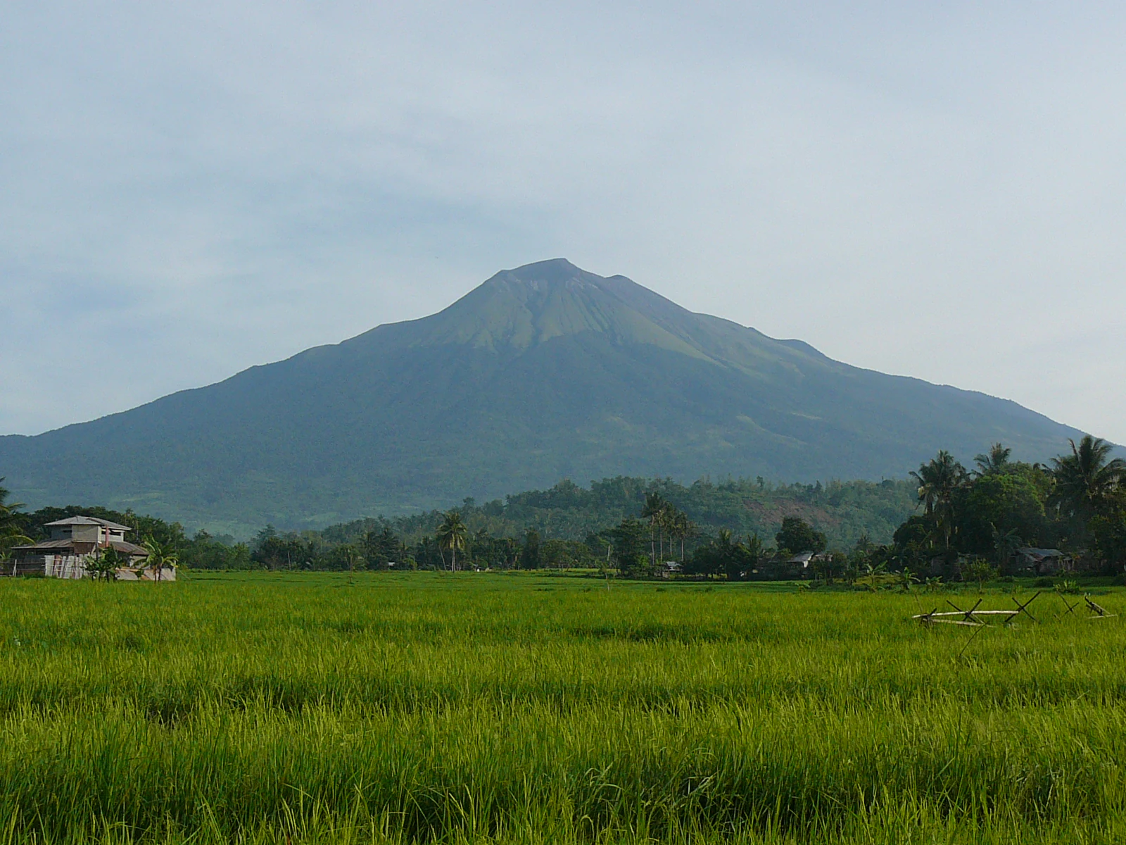
A wide shot of Mount Kanlaon, a large volcano, set behind vibrant green rice paddies under a hazy sky.
The majestic silhouette of Mount Kanlaon rising above lush agricultural fields.

Mount Kanlaon Natural Park history and protected-area timeline

Mount Kanlaon Natural Park traces its origins to 1934, when it was officially designated as a national park under Proclamation No. 721 issued on August 8 of that year. The original designation laid the groundwork for preserving the forests surrounding Mount Kanlaon, the highest peak on Negros Island.

For many years the park's forests lacked formal legislative protection, despite the early designation. This changed in 1997, when Proclamation No. 1005, issued on May 8, expanded the park's protection status and formally redefined the area as a natural park. Further institutional consolidation came on August 11, 2001, when the park was incorporated into the Philippines' National Integrated Protected Areas System (NIPAS), placing it under the country's principal biosphere and biodiversity protection framework and providing clearer legal mechanisms for conserving its forests and wildlife.

Over time, the park's significance as a refuge for endemic and threatened species has become increasingly apparent, reinforcing its role as a key conservation area in the Western Visayas. Its evolution from a classical national park to a formally recognized protected area reflects the broader shift in Philippine conservation policy toward integrated biodiversity protection under national law.

Mount Kanlaon Natural Park landscape and geographic character

The landscape of Mount Kanlaon Natural Park is dominated by the massive volcanic form of Mount Kanlaon, an active stratovolcano with a summit that rises to roughly 2,435 meters above sea level, making it the highest peak on Negros Island and a defining landmark of the central Philippines. The volcano's flanks and ridges give the park much of its dramatic topographic identity, with steep forested slopes, deep ravines, and high-elevation terrain that transitions from tropical forest to montane and heath-like vegetation at higher altitudes.

Surrounding the central volcanic massif, the park's terrain includes a mosaic of forested ridges, rolling highland areas, and lower-elevation agricultural lands and settlements near its borders. The communities of La Carlota City, San Carlos City, Canlaon City, and La Castellana lie at or near the park's edges, where farmland and forest meet along a gradually descending elevation gradient.

To the north, the park's mountainous backdrop continues into the separate but adjacent Northern Negros Natural Park, which includes other volcanic peaks such as Mount Silay and Mount Mandalagan. Together, these two reserves form a continuous belt of forested highland terrain across much of northern and central Negros, with Mount Kanlaon Natural Park serving as the southern anchor of this important island-wide conservation landscape.

Mount Kanlaon Natural Park ecosystems, habitats, and plant life

The natural character of Mount Kanlaon Natural Park centers on its extensive tropical rainforest, which covers a large share of the park's total area and acts as the primary ecological engine of the reserve. This rainforest stretches across the slopes and valleys around Mount Kanlaon, forming a continuous canopy that harbors a rich community of plant and animal species adapted to the wet, montane, and submontane conditions of Negros Island.

Beyond the closed forest, the park encompasses transitional vegetation types including higher-elevation heath and scrub communities on the upper volcanic slopes, where conditions become cooler and more exposed. The forested area transitions outward into agricultural and settlement lands at the park's periphery, creating an ecological gradient from intact rainforest to more human-modified habitats.

This vegetation mosaic supports a high level of biodiversity, particularly for species endemic to the Visayan island group. Because much of the original lowland forest elsewhere in the Philippines has been cleared or fragmented, the intact rainforest of Mount Kanlaon has become an increasingly important refuge for species that depend on continuous forest cover and high-quality habitat across their range on Negros and neighboring islands.

Mount Kanlaon Natural Park wildlife and species highlights

Mount Kanlaon Natural Park is recognized as one of the most important strongholds for threatened endemic wildlife in the Visayas. Its intact rainforest supports populations of several mammals found only in this region of the Philippines, most notably the Visayan warty pig (Sus cebifrons) and the Visayan spotted deer, also known as the Prince Alfred's deer (Cervus alfredi). Both species are considered highly endangered and have disappeared from much of their former range outside protected forest reserves.

The park is also notable for its bird life, with documented populations of a number of endemic and threatened Visayan bird species. Among the species recorded within the park are the Tarictic hornbill (Penelopides panini), the Negros fruit dove (Ptilinopus arcanus), the Negros bleeding-heart (Gallicolumba keayi), the spotted imperial pigeon (Ducula carola), and the Negros jungle flycatcher (Rhinomyias albigularis). Many of these birds have very limited ranges and are considered priorities for conservation in the Philippines.

The combination of rare endemic mammals and a diverse community of forest-dependent birds underscores the park's particular conservation value for Visayan fauna. As natural forest cover continues to decline elsewhere in the region, the wildlife populations sustained within Mount Kanlaon Natural Park take on growing importance for the long-term survival of several species.

Mount Kanlaon Natural Park conservation status and protection priorities

Mount Kanlaon Natural Park has long been regarded as a flagship protected area in the Western Visayas, both because of its association with the iconic Mount Kanlaon volcano and because of the irreplaceable biodiversity harbored within its forests. Its establishment in 1934 as a national park was an early recognition of the area's natural value, although the forest itself remained without strong legal protection for decades.

The 1997 expansion of its protection status and its 2001 inclusion under the National Integrated Protected Areas System (NIPAS) marked a turning point for the park's conservation framework, integrating it within the country's principal biodiversity and biosphere protection regime. This legal status provides the foundation for habitat protection, wildlife conservation, and management of activities within and around the park.

Ecologically, the park functions as a critical refuge for endemic Visayan species whose populations have been heavily reduced by deforestation and habitat loss elsewhere in the Philippines. Its large block of continuous forest offers one of the few remaining landscapes where species such as the Visayan warty pig, the Visayan spotted deer, and several endemic birds can be maintained at viable population levels. The park's conservation significance is therefore closely tied to its role as a biodiversity reservoir for an entire biogeographic region.

Mount Kanlaon Natural Park cultural meaning and human context

Mount Kanlaon Natural Park takes its name from Mount Kanlaon itself, a landmark with deep cultural resonance in the Visayas. The volcano and its surrounding forests have long shaped the identity, livelihoods, and landscape of communities across Negros Island, with the surrounding municipalities of La Carlota City, San Carlos City, Canlaon City, and La Castellana historically tied to the mountain's slopes.

Agriculture has long been practiced on the lower flanks and peripheral lands of the park, and the relationship between local communities and the natural areas around Mount Kanlaon reflects a long-standing interaction between settlement, farming, and protected forest. As conservation management of the park has strengthened, efforts to balance the protection of intact forest with the needs of surrounding communities have become an important dimension of the park's broader context, though specific cultural practices and traditions of the area's indigenous and local populations are not centrally detailed in available source material.

Top sights and standout views in Mount Kanlaon Natural Park

Mount Kanlaon Natural Park encompasses one of the most ecologically significant forest blocks on Negros Island, anchored by the active Mount Kanlaon volcano, which towers above much of the Western Visayas. Its combination of dramatic volcanic scenery and intact tropical rainforest sets it apart from many of the Philippines' smaller or more fragmented protected areas.

The park is especially notable as a refuge for endemic Visayan wildlife, including threatened mammals such as the Visayan warty pig and the Visayan spotted deer, as well as a community of rare forest birds found nowhere else. Its long history of formal protection, culminating in its inclusion under the national NIPAS framework, reinforces its importance as a pillar of biodiversity conservation in the central Philippines.

Best time to visit Mount Kanlaon Natural Park

The character of a visit to Mount Kanlaon Natural Park is shaped strongly by the tropical climate of Negros Island. The drier months typically offer clearer skies and more comfortable conditions for viewing the volcanic peak and exploring the park's forested terrain, while the wetter months bring heavier rainfall that affects trail conditions, visibility, and access to higher elevations. Wildlife observation in the park's rainforest can be productive year-round, but cooler, drier periods often make birdwatching and mammal sightings more accessible. Visitors generally find that the interplay between the park's volcanic topography and seasonal weather patterns is a defining part of any experience here, with the mountain's appearance changing dramatically between clear and mist-shrouded conditions.
Monthly climate preview

Long-term representative temperature and precipitation averages for Negros Occidental

Mount Kanlaon Natural Park Climate Normals and Annual Weather Patterns

Representative coordinate measurements reveal the annual temperature and monthly precipitation rhythm across Mount Kanlaon Natural Park. Detailed month-by-month climate normals provide comprehensive baseline data for analyzing long-term atmospheric patterns.
Annual mean25 °C
24 °C27 °C
Jan24°
Feb24°
Mar26°
Apr27°
May27°
Jun26°
Jul25°
Aug25°
Sep25°
Oct25°
Nov25°
Dec24°
Warmest month
May

27.2 °C

Coolest month
January

23.9 °C

Wettest month
July

9.5 mm/day

Driest month
March

2 mm/day

Park location guide

Geography guide, regional context, and park location map for Mount Kanlaon Natural Park

Mount Kanlaon Natural Park park geography, regions, and map view in Philippines

Understand where Mount Kanlaon Natural Park sits in Philippines through a broader geographic reading of the surrounding landscape, nearby location context, and its mapped position within the national park landscape.

How Mount Kanlaon Natural Park fits into Philippines

The Philippines, officially the Republic of the Philippines, is an archipelagic nation in Southeast Asia comprising approximately 7,641 islands categorized into three main geographical divisions: Luzon, Visayas, and Mindanao. Located in the western Pacific Ocean, it shares maritime borders with Taiwan, Japan, Palau, Indonesia, Malaysia, Vietnam, and China. Manila serves as the capital city, while Quezon City is the most populated city, both within Metro Manila.

Wider geography shaping Mount Kanlaon Natural Park in Philippines

The Philippines is an archipelagic nation in Southeast Asia, positioned in the western Pacific Ocean. Its islands are bounded by the South China Sea to the west, Philippine Sea to the east, and Celebes Sea to the south. The country shares maritime borders with Taiwan to the north, Japan to the northeast, Palau to the east and southeast, Indonesia to the south, Malaysia to the southwest, Vietnam to the west, and China to the northwest.

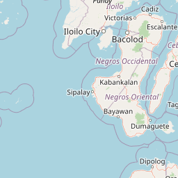
Map view of Mount Kanlaon Natural Park

Use this park location map to pinpoint Mount Kanlaon Natural Park in Philippines, understand its exact geographic position, and read its mapped placement within the surrounding landscape more clearly.

Pigeon | © OpenStreetMap contributors

Location context for Mount Kanlaon Natural Park

Negros OccidentalNegros Oriental

Visual reference for active volcanic terrain, highland ridges, and protected tropical rainforest habitats

Mount Kanlaon Natural Park Photos and Volcanic Landscape Scenery

Visual records illustrate the dramatic topography of Mount Kanlaon Natural Park, featuring active volcanic slopes, steep forested ravines, and dense tropical rainforest habitats across Negros Island. Examining protected area imagery provides a clearer understanding of high-elevation terrain, rugged mountain relief, and vital conservation environments.

A wide shot of Mount Kanlaon, a large volcano, set behind vibrant green rice paddies under a hazy sky.

A wide view of a dense, green hilly forest landscape under a bright, overcast sky, taken from an elevated vantage point with tree branches in the foreground.

Park atlas

Compare adjacent volcanic reserves and connected forest habitats across the region.

Explore Parks Near Mount Kanlaon Natural Park and Surrounding Protected Landscapes

Browse other parks near Mount Kanlaon Natural Park to examine related volcanic terrain and forested highland reserves. Continuing the geographic comparison reveals broader protected areas across the surrounding region.
Marine protected areaVisayas
About 43 km away#1 closest

East

Tañon Strait Protected Seascape: Marine Geography and Protected Landscape Analysis

An expansive marine passage located within the central Visayas island group.

As the largest marine protected area in the Philippines, the Tañon Strait Protected Seascape represents a complex aquatic geography spanning 160 kilometres. Its protected waters serve as a vital corridor for marine biodiversity, linking the northern Visayan Sea to the southern Bohol Sea. This resource provides a detailed look at the strait's maritime boundaries, coastal ecosystems, and the distinct underwater terrain that defines this critical conservation zone.

Area
5,000 km²
Established
1998
IUCN
V
Scope
Marine
Wildlife reserveNegros Occidental
About 55 km away#2 closest

South

Ilog-Hilabangan Watershed Forest Reserve: Geography and Protected Forest Boundaries

A vital wildlife reserve and watershed landscape in Negros Occidental

This protected area covers a vast expanse of lowland and montane tropical forest in the heart of Negros Island. By regulating the headwaters of major rivers and maintaining a secure habitat for threatened endemic species, the reserve acts as a fundamental component of the regional geography and biodiversity network in the Western Visayas.

Area
102.11 km²
Established
1990
Relief
Mountain
Scope
Terrestrial
National parkCebu
About 61 km away#3 closest

Southeast

Guadalupe Mabugnao Mainit Hot Spring National Park: Protected Landscape and Watershed Geography

Explore hot springs, caves, and mapped terrain in Cebu.

Guadalupe Mabugnao Mainit Hot Spring National Park is a protected national park in Cebu, Philippines, recognized for its significant watershed function and unique natural features. Spanning forested highland terrain within the Mantalongon mountain range, the park protects natural hot springs, explored cave systems such as Cave Lorett, and river networks vital to local water supply. Its identity as a protected landscape offers rich opportunities for geographic exploration, mapping its boundaries, and understanding its role within the regional natural terrain and conservation efforts.

Area
0.575 km²
Established
1972
IUCN
V
Relief
Mountain
National parkPhilippines
About 86 km away#4 closest

Northwest

Bulabog Putian National Park: Philippines National Park Geographic Context and Mapped Boundaries

Discover the protected landscape identity and regional atlas significance.

Bulabog Putian National Park stands as a designated national park in the Philippines, offering valuable insights for geographic and protected-area exploration. Users can understand its specific location and mapped presence within the country's natural landscape, contributing to a structured atlas of conservation areas. This entry focuses on the park's identity and geographic setting for informed discovery.

Area
8.543 km²
Established
1961
IUCN
V
Relief
Mountain
A watercolor painting showing a panoramic view of a lush wetland landscape with gentle green hills in the distance, a winding stream, and tall grasses and pink wildflowers in the foreground.
Wildlife reserveCentral Visayas
About 102 km away#5 closest

East

Olango Island Wildlife Sanctuary: Coastal Protected Area and Migratory Bird Habitat in Central Visayas

Explore the interconnected mudflats, reefs, and mangrove forest ecosystems

Olango Island Wildlife Sanctuary stands as a key protected landscape in the Central Visayas, defined by its vast tidal flats and critical role in international bird migration patterns. This site features a unique mosaic of salt marshes, seagrass beds, and coral reef systems that support diverse coastal life within the low-lying terrain of the Olango Island Group.

Area
10.3 km²
Established
1992
Relief
Lowland
Climate
Tropical
A horizontal watercolor painting showing a soft, hazy landscape with a body of water in the foreground, grassy banks, and rolling hills in the distance.
National parkCentral Visayas
About 118 km away#6 closest

Southeast

Panglao Island Protected Seascape: Geographic Atlas and Marine Park Boundaries

A vital protected marine zone in Central Visayas

The Panglao Island Protected Seascape acts as a key site for studying tropical marine biodiversity and karst-driven coastal geography in the Philippines. Spanning the waters around Panglao Island, this protected area features a mosaic of coral reefs, white sand beaches, and offshore limestone islets that provide essential habitats for thousands of mollusk and crustacean species.

Area
91.12 km²
Established
2018
Relief
Mixed relief
Scope
Mixed
Protected landscapeBohol
About 134 km away#7 closest

Southeast

Rajah Sikatuna Protected Landscape: Mapping the Limestone Forest of Bohol, Philippines

A vital protected area of karst ridges and endemic forest habitats

Rajah Sikatuna Protected Landscape sits as a premier natural landmark in southern Bohol. This area is defined by its extensive karst topography, significant cave systems, and expansive limestone forests. It serves as an essential ecological anchor for the province, offering a unique perspective on the island's diverse upland geography and natural mountain systems.

Area
104.526 km²
Established
1987
IUCN
V
Relief
Mountain
A soft watercolor painting of a coastal landscape with green rolling hills, distant faint mountains, and light water reflections.
Protected landscapeLeyte
About 167 km away#8 closest

East

Cuatro Islas Protected Landscape/Seascape: Leyte Marine and Island Geography Exploration

Detailed protected area atlas for the Camotes Sea island group

The Cuatro Islas Protected Landscape/Seascape is a notable Philippine conservation zone consisting of four distinct islands including Apid, Mahaba, Digyo, and Himokilan. This geographic profile details the diverse terrain, ranging from uplifted former coral reefs to coral sand islets, while providing a clear understanding of the surrounding marine ecosystem and its role in regional conservation.

Area
125 km²
Established
2000
Scope
Mixed

Common questions about visiting, size, designation, and location context for Mount Kanlaon Natural Park

Mount Kanlaon Natural Park FAQs for park facts, access, geography, and protected area context

Find quick answers about Mount Kanlaon Natural Park, including protected-area facts, park geography, trail and visitor context, and how the park fits into its surrounding country and regional landscape.
MoriAtlas Explorer

Continue Your Protected Areas Search Across the Global Atlas

Deepen your exploration by continuing the structured search for national parks and protected areas worldwide. Utilize the comprehensive filtering capabilities to compare different conservation landscapes and refine your understanding of global park geography. Discover more about the distribution and characteristics of protected natural areas.

Global natural geography