Peaks
Fay Peak
1,981 m

A comprehensive analysis of terrain elevation, landscape features, and park extent.
This structured geographic profile details the physical characteristics of Mount Rainier National Park, spanning 956.6 square kilometers across Washington. The data encompasses precise boundary measurements, elevation ranges from 490 to 4390 meters, and a variety of habitats including alpine meadows, temperate forests, and glacial systems. Detailed records of peaks and natural features provide context for the mountainous terrain within these protected boundaries.
Related tags
Glaciated stratovolcano sanctuary in the Washington Cascades
Mount Rainier National Park protects a dramatic glaciated stratovolcano in the Pacific Northwest United States, standing as the highest peak in the Cascade Range at 14,410 feet. Established in 1899 as the nation’s fifth national park, the 236,381-acre preserve encircles Mount Rainier itself, preserving a complete volcanic ecosystem that rises abruptly from the surrounding landscape. The park encompasses subalpine meadows, old-growth forests, deep valleys, and more than 25 glaciers descending the volcano’s flanks, creating one of the most ecologically diverse protected landscapes in North America. Located in southeast Pierce County and northeast Lewis County in Washington State, the park receives approximately 1.6 million visitors annually who come to experience its mountaineering opportunities, wilderness trails, and the iconic scenery of a glaciated volcano looming above ancient forests.
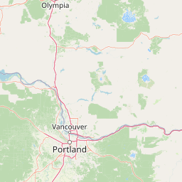
National and regional placement within the United States of America
Mount Rainier’s stored outline encompasses 956.6 km²
Explore recorded vertical range limits and internal natural landscape features
Peaks
1,981 m
Peaks
1,355 m
Peaks
2,041 m
Peaks
Viewpoints
Waterfalls
Alpine climate zones, glacial hydrology, and partial forest cover profiles
Mountains · Volcano · Glacier · Valleys · Waterfalls · Forest · Lakes · Rivers · Wetland
Alpine meadow · Tundra habitat · Temperate coniferous forest · Montane forest · Wetland · Riverine habitat · Lacustrine habitat · Glacial habitat
Trace the regional park geography of the Pacific Northwest, comparing diverse protected landscapes near Mount Rainier National Park.

South

Mapping volcanic peaks, deep river canyons, and old-growth wilderness corridors
Gifford Pinchot National Forest represents a major protected expanse in the Washington Cascades, characterized by a complex volcanic topography that includes active craters, cinder cones, and rugged lava fields. This atlas entry details the forest's primary geographic features, from the high-elevation alpine terrain of the Goat Rocks to the river-carved valleys of the Lewis and Cowlitz systems, providing essential context on this integral Pacific Northwest protected landscape.

North
Exploratory atlas of Washington's primary Cascade Range wilderness
Delve into the structural geography of Mount Baker, Snoqualmie National Forest. This protected area corridor serves as a major ecological transition zone between the Puget Sound lowlands and the interior Cascades, characterized by extensive glaciers, wild river systems, and iconic stratovolcanoes that define the regional landscape of Washington state.

Northeast
Mapping ecological gradients and wilderness boundaries across the eastern Cascade Range
Spanning from the moist coniferous forests of the western Cascades to the arid plateaus of the Okanogan, this massive national forest protects an unmatched diversity of terrain. Explore the intricate geography of river-carved valleys, glacial cirques, and remote wilderness areas that characterize this critical environmental corridor in the Pacific Northwest.
South
Mapping the high altitude meadows and volcanic ridges
Spanning roughly 47,700 acres, Mount Adams Wilderness presents a unique geological mosaic of cinder cones, lava flows, and permanent snowfields. The area offers a profound look at Cascade Range geography, from its western forested valleys to its open alpine basins, serving as a critical protected landscape for understanding volcanic, glacial, and fluvial processes in the Pacific Northwest.
South
Volcanic peaks, high-elevation lakes, and expansive meadows in Washington.
Indian Heaven Wilderness encompasses a broad volcanic plateau in the southern Washington Cascades, famous for its dense concentration of lakes, ponds, and volcanic landforms. The area features a complex mosaic of cinder cones, shield volcanoes, and subalpine forests, offering a unique geographic perspective on the Pacific Northwest. Delve into the protected boundaries and mapped terrain of this significant wilderness area.
Northwest
Temperate rainforests, alpine ridges, and fjord shorelines
Olympic National Forest defines the outer reaches of the Olympic Mountains, featuring a massive expanse of old-growth conifers and high-precipitation temperate rainforests. This protected area connects diverse ecosystems ranging from the brackish waters of Hood Canal to rugged, snow-dusted subalpine ridges. Our detailed geographic mapping highlights the forest's role as a vital buffer and wilderness corridor within the broader Pacific Northwest landscape.

North
A detailed look at one of the most remote volcanic reserves in the Cascade Range.
Defined by the presence of an isolated stratovolcano and extensive glacial systems, Glacier Peak Wilderness represents a significant protected area within the Washington Cascades. This overview details the rugged landscape, from the deeply incised river valleys of the Chiwawa and Suiattle to the high-alpine rock and ice environment at the peak summit, providing essential geographic context for this roadless wilderness.

South
Exploring the Cascade Range terrain and wilderness boundaries in Oregon.
Mount Hood National Forest encompasses a vast, rugged expanse of the Oregon Cascades, anchored by the iconic, glacier-clad Mount Hood. This protected landscape contains extensive old-growth forests, high-alpine lakes, and deep river canyons. Discover the geographic extent of these wilderness areas and mountain terrain within the MoriAtlas database of protected lands.
Delve deeper into the specifics of Mount Rainier National Park, a critical protected area in Washington State. Understand its precise geographic setting, mapped boundaries, and the regional landscape context it provides. This detailed view offers a solid foundation for further atlas-based discovery and understanding of protected natural areas across the United States.