
Why Mount Timpanogos Wilderness stands out
Mount Timpanogos Wilderness is best known for protecting the towering Wasatch peak of Mount Timpanogos and its surrounding alpine terrain within easy reach of two major Utah metropolitan areas. The wilderness combines a singular mountain landmark with a classic Wasatch mix of glacial cirques, forested canyons, high basins, and small alpine lakes such as Emerald Lake. The area is also well known for its wildlife, especially its population of Rocky Mountain goats in the high country around Emerald Lake, along with mule deer, elk, moose, black bear, and mountain lion. The combination of a single iconic summit, accessible trailheads, and a strong subalpine flora and fauna profile makes the wilderness one of the most recognizable protected landscapes in Utah.
Mount Timpanogos Wilderness history and protected-area timeline
The lands that now make up Mount Timpanogos Wilderness were historically part of the national forest system managed by the federal government as part of what eventually became the Uinta-Wasatch-Cache National Forest. For much of the early and mid-twentieth century, Mount Timpanogos itself was a well-known regional landmark visible throughout the Wasatch Front, and interest in protecting its slopes grew alongside broader post-war support for wilderness preservation in the American West.
The wilderness area was formally established in 1984, when a portion of the national forest surrounding Mount Timpanogos was designated under the National Wilderness Preservation System. The designation brought higher levels of protection to the mountain and its surrounding basins, limiting road building and mechanized use, and it consolidated the central Wasatch's growing network of wilderness areas, joining the neighboring Lone Peak Wilderness to the north.
Earlier in the area's modern history, the mountain was also the site of a notable aviation accident. On March 9, 1955, a U.S. Air Force B-25 bomber, bound for March Air Force Base in California, crashed on the east side of Mount Timpanogos in poor weather, killing three crew members and two passengers. A roughly one-mile spur trail now leaves the main Timpooneke trail near the lip of Timpanogos Basin and leads to the crash site, where remnants of the aircraft, such as radial engines, are still visible against the alpine landscape. This site has become an informal historical landmark within the wilderness, layering human history onto the mountain's natural heritage.
Mount Timpanogos Wilderness landscape and geographic character
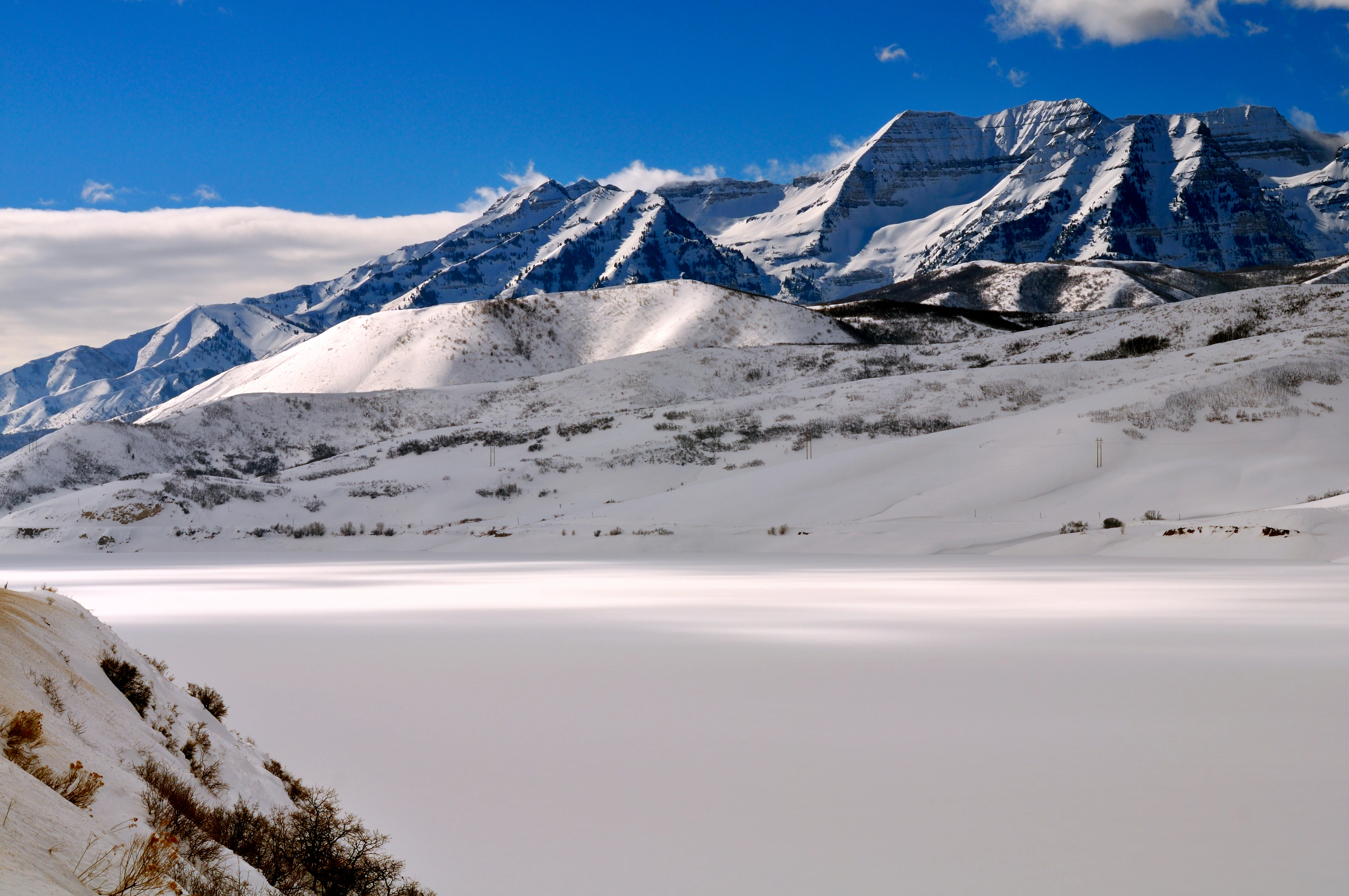
The landscape of Mount Timpanogos Wilderness is dominated by the massive form of Mount Timpanogos itself, which rises from the populated valleys of Utah County to an elevation near 11,750 feet. The peak is the focal point of the wilderness and forms part of the front range of the Wasatch Mountains, the bold eastern wall of mountains that rises above the Wasatch Front and the Great Basin foothills. Because the mountain sits so close to the urban valleys below, its profile is unusually prominent and immediate, giving the wilderness a strong vertical character.
The wilderness's terrain reflects classic Wasatch alpine scenery shaped by glaciers and weathering. Steep ridges, cirques, and rocky basins descend from the upper slopes, feeding into forested canyons such as those associated with American Fork on the north and the Timpanogos Basin on the south. Emerald Lake sits in a high cirque basin along the route from Timpooneke, surrounded by cliffs and talus slopes that are typical of the mountain's glacial past. Below these alpine features, the mountain transitions into a thick belt of forest before dropping steeply into the canyon bottoms.
Two timbered canyons frame the wilderness at its lower edges. American Fork Canyon marks much of the northern boundary, while Provo Canyon lies to the south. Between them, the wilderness fans out across the flanks and upper slopes of Mount Timpanogos, with the mountain's ridges and drainages radiating outward toward the valleys. This combination of a single dominant peak, glacial high country, deep forested canyons, and direct adjacency to a major urban corridor defines the wilderness's landscape identity.
Mount Timpanogos Wilderness ecosystems, habitats, and plant life
The Mount Timpanogos Wilderness supports a vertical sequence of vegetation zones that change with elevation, all compressed into a relatively compact area around the central peak. Below the tree line, the mountainsides are covered by extensive forests of aspen, Douglas fir, subalpine fir, limber pine, Gambel oak, maple, and chokecherry. These mixed forests, especially the stands of quaking aspen, are one of the most striking seasonal features of the wilderness, giving way in fall to broad swaths of golden color against the darker conifers.
Above the tree line, vegetation thins into subalpine and alpine communities, with hardy wildflowers taking over the open slopes. The wilderness is known for displays of forget-me-nots, alpine buttercups, bluebells, arnica, larkspur, yarrow, sulfur buckwheat, geraniums, and columbines. These wildflower communities add strong seasonal color to the basin's rocky meadows and talus slopes, particularly in mid to late summer when snow has receded from the higher elevations.
The combination of dense montane forests, subalpine parks, and exposed alpine zones gives Mount Timpanogos Wilderness a tightly layered ecological profile. Although small in total acreage, the wilderness captures many of the classic vegetation transitions of the central Wasatch, from low-elevation oak and maple communities up through conifer belts to alpine tundra-like environments near the summit.
Mount Timpanogos Wilderness wildlife and species highlights
Wildlife in Mount Timpanogos Wilderness reflects the diversity of habitats packed into its elevation range. The most distinctive local resident is the Rocky Mountain goat, which is found in the rugged terrain around Emerald Lake on the upper mountain. Herds of these goats are one of the wilderness's signature wildlife features and are regularly seen by hikers approaching the summit via the Timpooneke route.
Larger mammals are also present throughout the forested and subalpine zones. Mule deer are common across the slopes, while elk and moose are found in wetter areas and drainages, especially in brushy and riparian pockets. Predators such as mountain lion and black bear roam the wilderness, and black bears in particular are a well-known presence in the area's berry-rich subalpine habitats. The mixture of browsers, ungulates, and predators gives the wilderness a complete picture of high-country mammal ecology in the Wasatch.
The mountain's cliffs and open skies also support raptors, and several species of birds of prey hunt across the wilderness. Together with the wide range of forest songbirds and alpine-breeding species, this makes the area a meaningful birdlife zone, supplementing its more visible mammal population. The concentration of ungulates, mountain goats, and predators in such close proximity to a major urban corridor adds to the importance of the wilderness as a refuge for Wasatch wildlife.
Mount Timpanogos Wilderness conservation status and protection priorities
Mount Timpanogos Wilderness was designated in 1984 as part of the National Wilderness Preservation System, giving its alpine and forested slopes a higher level of protection than the surrounding national forest lands. Its conservation role is heightened by its location directly above one of the most rapidly urbanizing corridors in the Intermountain West, the Wasatch Front, which places sustained pressure on adjacent open lands.
The wilderness protects important habitat for species such as Rocky Mountain goats, mule deer, elk, moose, black bear, and mountain lion, as well as a vertical sequence of vegetation zones that includes large aspen and conifer forests and sensitive alpine plant communities. By keeping roads, mechanized travel, and large-scale development out of the area, the designation helps maintain watershed function, wildlife connectivity, and habitat quality along the central Wasatch.
Its proximity to the neighboring Lone Peak Wilderness also strengthens the conservation value of the area, contributing to a broader corridor of protected high country along the Wasatch Front. Although the wilderness receives significant hiking pressure, its designation ensures that the mountain's most ecologically important terrain remains in a largely natural state and continues to function as a refuge for the plants and animals of the central Wasatch.
Mount Timpanogos Wilderness cultural meaning and human context
Mount Timpanogos holds a deep place in the regional identity of Utah and the broader Wasatch Front. The peak is one of the most recognized natural landmarks in the state and features prominently in local lore, photography, and outdoor recreation culture. For communities along the Wasatch Front, especially in Utah County, the mountain is both a defining natural symbol and a long-standing outdoor destination, long predating its official wilderness designation.
The mountain also carries the memory of human events that have become part of its cultural landscape, none more visible than the 1955 B-25 bomber crash on the east side of the peak. The crash site, accessible by a spur trail from the Timpooneke route, has become a destination of its own for hikers interested in local history. It adds a layer of mid-twentieth-century military and aviation history to the wilderness and serves as a reminder of how the mountain has intersected with broader American stories beyond recreation and ecology.
Top sights and standout views in Mount Timpanogos Wilderness
The standout feature of Mount Timpanogos Wilderness is the peak itself: Mount Timpanogos, a near 11,750-foot summit that anchors the entire wilderness and defines the Wasatch skyline above Provo and Pleasant Grove. The wilderness wraps around this single mountain, giving it an unusually focused and dramatic setting.
The high country around Emerald Lake, with its cliffs, glacial basin, and population of Rocky Mountain goats, is another defining highlight, combining classic alpine scenery with some of the wilderness's most visible wildlife. The trail system from the Timpooneke and Aspen Grove trailheads adds further distinction, tying together forest, subalpine basin, alpine lake, summit, and historic crash site in a single accessible route.
Best time to visit Mount Timpanogos Wilderness
The character of Mount Timpanogos Wilderness shifts strongly with the seasons, and the most rewarding periods to experience the area are typically from late spring through early autumn. In summer, snow recedes from the high routes, wildflowers such as forget-me-nots, buttercups, bluebells, arnica, and columbines bloom across the subalpine and alpine zones, and the two main trail corridors to the summit become reliably accessible.
Early autumn brings cooler temperatures and the brilliant gold of the aspen stands across the mountain's mid-slopes, which is widely regarded as one of the most photogenic seasons in the Wasatch. Winter transforms the wilderness into a snow-covered alpine environment, with the mountain's snowy profile becoming one of the most recognizable sights from the valleys below, though high-elevation trails become far more challenging and conditions demand winter travel skills and equipment. Spring is a transitional period, with lower trails opening earlier, but upper basins and the summit route often remain snowbound until well into the season.