
Mori Atlas logo
Wildlife reserveMousa, Shetland

Tracing the geological terrain and protected seabird habitats of this significant northern island reserve

Mousa, Shetland Wildlife Reserve: A Mapped Exploration of Coastal Landscapes and Ancient Heritage

Mousa, Shetland stands as a distinct protected landscape within the Shetland archipelago, known for the exceptionally preserved Iron Age Broch and its global importance as a European storm-petrel colony. This wildlife reserve encompasses rugged sandstone coastal cliffs and rich marine environments that support diverse seabird populations. Explore the geographic footprint of this island, where two millennia of archaeological history intersect with critical North Atlantic conservation habitats.

uninhabited islandShetland archipelagoIron Age brochstorm-petrel colonyseabird breedingmarine protected area
A flat-style digital illustration showing a waterfall cascading over rocky cliffs into a stream; green hills and coniferous trees frame the scene under a pink and yellow sunset sky.

Mousa, Shetland

Wildlife reserve

Park overview

Structured park overview, official facts, and landscape profile for Mousa, Shetland

Mousa, Shetland park facts, protected area profile, and essential visitor context

Review the core facts for Mousa, Shetland, including designation, size, terrain, visitor scale, habitats, and operating context in one park-focused overview.

About Mousa, Shetland

Mousa is a small, uninhabited island in the Shetland archipelago, separated by only about a nautical mile from the east coast of Mainland Shetland in the parish of Dunrossness. It sits on the 60th parallel north, placing it halfway between the equator and the North Pole, and is almost split in two by the inlets known as East and West Hams. Although modest in area, the island has an outsized identity shaped by an unusually rich combination of geology, wildlife, and prehistoric archaeology.

The island's terrain reflects a base of alternating sandstone and muddy limestone that weathers into fertile soil capable of supporting diverse plant communities despite constant exposure to salt spray, wind, and grazing. This fertility has historically sustained human activity on the island, including quarrying that supplied flagstone for Lerwick. The old Norse name for Mousa, Mósey, reflects the island's character as a mossy or moor-covered landfall, and the Norse even counted it as two islands based on their ability to drag boats between East and West Hams.

Mousa's modern significance rests equally on its Iron Age broch and its conservation designations. The Broch of Mousa dominates the landscape and represents a remarkable survival of prehistoric architecture, while the island's status as a major seabird breeding site, particularly for storm-petrels, places it on a range of international and national conservation lists. Managed today as an RSPB reserve and recognized by BirdLife International, Mousa functions as both a heritage landmark and a cornerstone of marine and coastal conservation in Shetland.

Quick facts and research context for Mousa, Shetland

Mousa is a small island in the Shetland Islands of Scotland, uninhabited since the nineteenth century, administratively part of the Shetland Islands council area. It lies about 2 kilometres off Mainland Shetland and roughly 30 kilometres south of Lerwick. The island is just under 2.5 kilometres long and about 1.5 kilometres wide at its broadest point, with a maximum elevation of around 55 metres.

Geologically, Mousa features alternating hard sandstone and muddy limestone beds that weather into fertile soil. The island is protected for its breeding European storm-petrels and for its supporting marine ecosystem, and is designated as a Special Protection Area, a Site of Special Scientific Interest, a Nature Conservation Marine Protected Area, and an Important Bird Area.

Protection and recognition

Examine the documented protection scope and international recognition framework.

Mousa, Shetland Protection Status and Designated Conservation Geography

Mousa, Shetland maintains a mixed protection scope outlining its formal conservation governance and administrative status. Documented designation details provide a clear baseline for evaluating regional management frameworks and protected area boundaries.

Protection details

Protection scope
Mixed
Transboundary protection
No
Park context

Deeper park guide and search-rich context for Mousa, Shetland

Mousa, Shetland history, landscape, wildlife, and travel context

Explore Mousa, Shetland through its history, landscape character, ecosystems, wildlife, conservation priorities, cultural context, and seasonal travel timing in a structured park guide built for atlas discovery and search intent.

Why Mousa, Shetland stands out

Mousa is best known for two very different but complementary features. The first is the Broch of Mousa, a roughly 2,000-year-old Iron Age round tower that is one of the best-preserved brochs in the British Isles and the focal point of the island's archaeological significance. The second is its role as a stronghold for European storm-petrels, hosting around 6,800 breeding pairs, which represent a substantial share of both the British and global population. This exceptional seabird presence, together with rich surrounding marine life supported by a notable sandeel population, gives Mousa a conservation significance well beyond its small size.
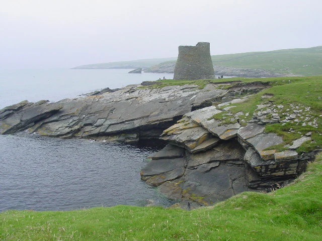
A stone Iron Age tower known as a broch sits on a grassy, rocky coastline overlooking the sea under a misty, overcast sky.
The Iron Age Mousa Broch standing on the coastal cliffs of Mousa island.

Mousa, Shetland history and protected-area timeline

Mousa has a deep human past despite its current lack of permanent residents. The island's defining historical feature is the Broch of Mousa, an Iron Age round tower that stands about 13 metres high and is widely regarded as the best-preserved broch in the British Isles. Built around 2,000 years ago, it originally formed part of a pair with a now much less intact broch at Burland on the nearby Mainland, the two flanking Mousa Sound as a chain of visible fortifications across southern Shetland. The surrounding landscape contains ruined croft houses that hint at later settlement phases, and clearance work on the broch took place in 1860 and again in 1919.

The island also appears in the Orkneyinga Saga, where it is described as a place of refuge during raids and as a sanctuary used by lovers escaping wider conflict, suggesting both strategic and romantic roles in Norse-era Shetland. A later, more concrete historical event occurred in July 1558, when two Scottish ships from Aberdeen, the Meikle Swallow and Little Swallow, attacked an English fleet off Shetland and seized cattle and goods belonging to Olave Sinclair on Mousa. Sinclair subsequently pursued compensation through the Edinburgh courts, leaving a documented trace of the island's commercial life in the sixteenth century.

Mousa, Shetland landscape and geographic character

Mousa is a low but rugged island whose form is shaped by ancient sedimentary geology and by the relentless marine weather of the northern North Sea. Its rocks consist of alternating beds of hard sandstone and muddy limestone, and the softer limestones weather into a surprisingly fertile soil that supports rich vegetation despite constant salt spray and exposure. The island's coastline is deeply indented, with East and West Hams cutting far enough inland that the Norse treated them as a dividing line between two islands, and higher ground rises to around 55 metres above sea level.

Along the shore, features such as the Peerie Bard on the east coast illustrate the island's sea-cut cliffs and rocky platforms, while inland, the flagstone quarries historically used for Lerwick's construction material reveal the layered sandstone at the surface. From the mainland, the silhouette of Mousa rises from the sea as a compact, heather-clad landmass, with the tall, conical form of the broch visible against the skyline on clear days and vanishing into mist or snow squalls in harsher weather.
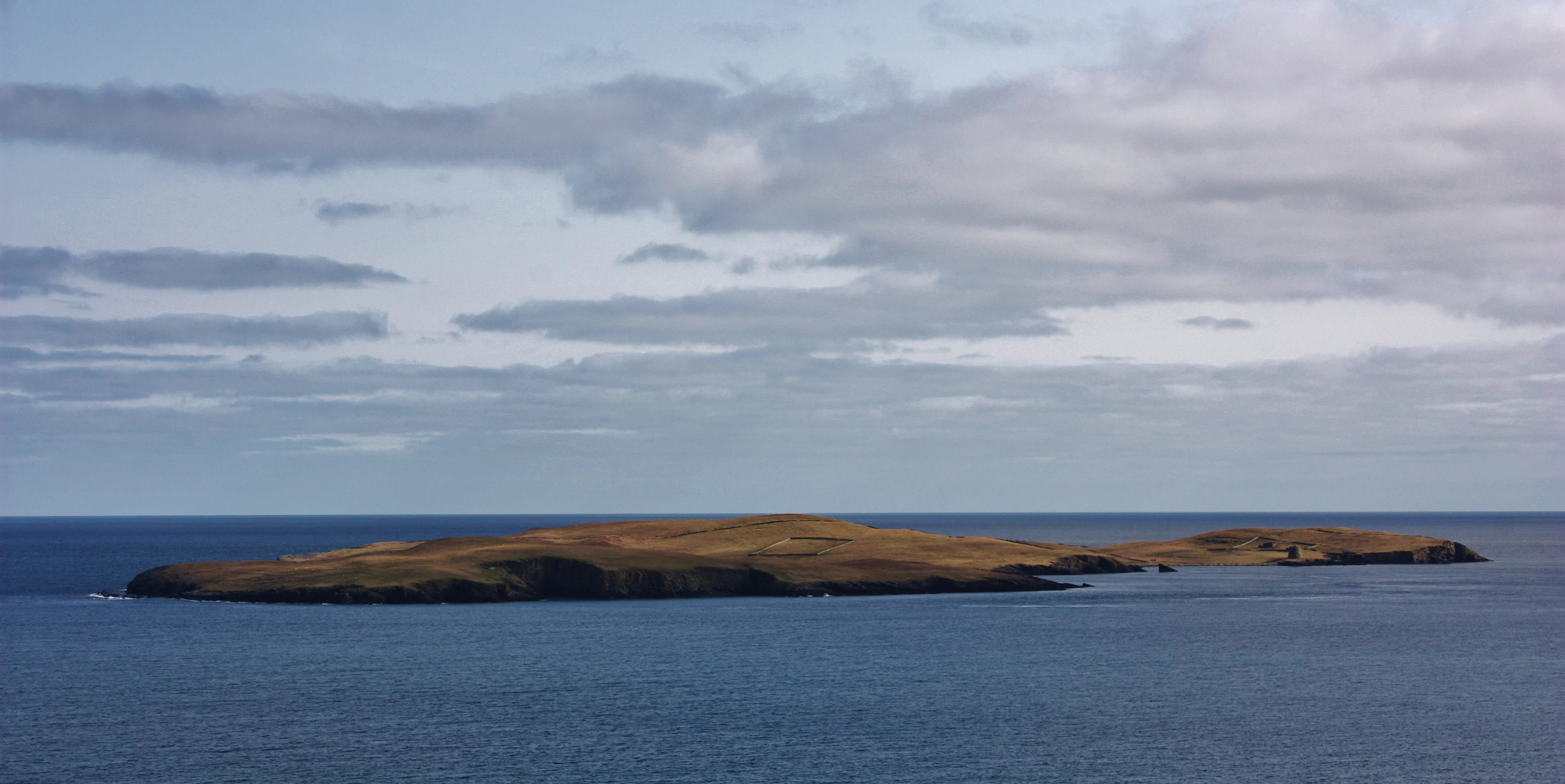
A distant, elevated view of the grassy island of Mousa surrounded by open ocean under a cloudy sky.
Aerial view of the island of Mousa, off the coast of the Shetland mainland.

Mousa, Shetland ecosystems, habitats, and plant life

Although small, Mousa hosts an ecologically dense mosaic of habitats, from coastal cliffs and rocky shores to herb-rich grasslands and more sheltered inland areas. The fertility of its soil, derived from weathering limestone and other marine sediments, allows plant communities such as sheep's-bit and creeping willow to thrive in the herb-rich grassland despite grazing sheep, wind exposure, and salt spray. This combination of weather and soil produces a distinctive botanical character uncommon for such a small and exposed island.

The surrounding marine environment is equally important to Mousa's ecological identity. A population of sandeels in the waters around the island is described as the most reliable of all the seas in the Shetland region, providing a fundamental food source that links the entire local food web. This marine productivity underpins Mousa's value as a seabird and marine mammal haven, and has been recognized through multiple conservation designations covering both the land and the surrounding sea.
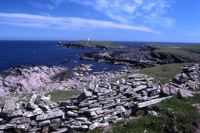
A rocky coastal headland on Mousa island with a stone wall in the foreground and the sea in the background under a blue sky.
The rocky Peerie Bard headland on the east coast of Mousa.

Mousa, Shetland wildlife and species highlights

Mousa's wildlife profile is shaped heavily by the sea that surrounds it. Seals are a regular presence on the island's shores, with both grey seals and common seals hauled out along the coast. Seabirds dominate the airspace and cliffs, with black guillemots breeding around the island and Arctic terns nesting on more sheltered ground. The island's most celebrated wildlife feature, however, is its colony of European storm-petrels, with approximately 6,800 breeding pairs representing around 8 percent of the British population and roughly 2.6 percent of the global population.

The richness of the surrounding waters extends Mousa's wildlife significance beyond its coastline. Sandeels sustain fish, seabirds, and marine mammals alike, and the wider sea area is widely used by cetaceans such as whales and dolphins. The combined land and marine wildlife value has positioned Mousa on multiple national and international bird and habitat lists.

Mousa, Shetland conservation status and protection priorities

Mousa carries one of the most layered conservation profiles in Shetland, reflecting the unusual overlap of seabird importance, marine productivity, and protected-site status. The island itself is designated as a Special Protection Area under European nature legislation and as a Site of Special Scientific Interest by NatureScot, with management of the island as a reserve overseen by the RSPB. BirdLife International has further recognized Mousa as an Important Bird Area, formalizing its international significance for breeding seabirds, particularly storm-petrels.

The waters around Mousa are protected in their own right. They form a Special Area of Conservation and a Nature Conservation Marine Protected Area, a designation driven in large part by the sandeel population that sustains the broader marine food web. Together, the island and its surrounding sea create a continuous conservation zone whose value comes not just from any single species but from the ecological chain linking seabirds, seals, fish, and the underlying marine habitat.

Mousa, Shetland cultural meaning and human context

The cultural resonance of Mousa runs from Norse saga literature to sixteenth-century court records and into modern archaeological and conservation narratives. Its appearance in the Orkneyinga Saga as a refuge during raids and a retreat for lovers ties the island into the broader Norse storytelling tradition of the North Atlantic, while the 1558 raid on Mousa by Scottish ships from Aberdeen and the subsequent legal claim by Olave Sinclair reveals the island's role in regional maritime conflict and commerce.

Top sights and standout views in Mousa, Shetland

The single most striking feature of Mousa is the Broch of Mousa itself: a complete, towering Iron Age round tower still dominating its island landscape after two millennia. Equally remarkable, given the island's small size, is its international importance for European storm-petrels, making Mousa a place where prehistoric architecture and modern seabird conservation share the same ground.

The surrounding marine environment adds a third highlight, with some of the most reliable sandeel habitat in Shetland supporting a wide community of seabirds, seals, and cetaceans. This combination of a highly visible ancient monument, an internationally important seabird colony, and a protected marine ecosystem gives Mousa a layered identity unusual for an uninhabited island of less than two hundred hectares.

Best time to visit Mousa, Shetland

The character of a visit to Mousa shifts markedly with the seasons. Summer is the most rewarding period for most visitors, bringing longer daylight, calmer ferry conditions to and from Sandwick at Leebitton, and the peak presence of breeding seabirds including storm-petrels, Arctic terns, and black guillemots. Midsummer also offers the best chance to experience the richly vegetated grasslands at their most developed.

Spring and early autumn can offer quieter conditions and a different atmospheric quality, with shifting light over the broch and the chance of dramatic weather sweeping across the island from the North Sea, as suggested by the island's reputation for sudden snow showers and sea haar. Winter visits are uncommon and constrained by limited transport, but the brooding, weather-laden landscape of Mousa in winter reinforces the sense of remoteness that has shaped its human and ecological history.
Monthly climate preview

Measured monthly temperature ranges and precipitation averages for Mousa, Shetland

Mousa, Shetland Climate Normals and Long Term Weather Patterns

Long term climate data for Mousa, Shetland records measured annual temperature and precipitation rhythms across representative coordinate sampling. Reviewing the complete monthly profile provides detailed context on baseline thermal and moisture shifts throughout the year.
Annual mean9 °C
6 °C13 °C
Jan
Feb
Mar
Apr
May
Jun10°
Jul12°
Aug13°
Sep12°
Oct10°
Nov
Dec
Warmest month
August

13.1 °C

Coolest month
February

5.9 °C

Wettest month
November

4 mm/day

Driest month
May

1.8 mm/day

Park location guide

Geography guide, regional context, and park location map for Mousa, Shetland

Mousa, Shetland park geography, regions, and map view in United Kingdom

Understand where Mousa, Shetland sits in United Kingdom through a broader geographic reading of the surrounding landscape, nearby location context, and its mapped position within the national park landscape.

How Mousa, Shetland fits into United Kingdom

The United Kingdom is a parliamentary constitutional monarchy located in northwestern Europe, consisting of four constituent countries: England, Scotland, Wales, and Northern Ireland. As a major global power with over 69 million residents, it maintains significant international influence in politics, economics, and culture.

Wider geography shaping Mousa, Shetland in United Kingdom

The United Kingdom is an island nation located in northwestern Europe, surrounded by the Atlantic Ocean, North Sea, English Channel, Celtic Sea, and Irish Sea. It shares a land border with the Republic of Ireland to the west. The territory includes the island of Great Britain, the northeastern portion of Ireland, and most of the smaller British Isles islands.

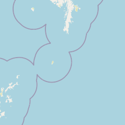
Map view of Mousa, Shetland

Use this park location map to pinpoint Mousa, Shetland in United Kingdom, understand its exact geographic position, and read its mapped placement within the surrounding landscape more clearly.

Pigeon | © OpenStreetMap contributors

Location context for Mousa, Shetland

ScotlandShetland Islands

Visualizing protected coastal habitats and ancient island terrain

Mousa, Shetland Photos and Landscape Scenery Exploration

Visual records reveal the rugged terrain, coastal cliffs, and seabird habitats that define Mousa, Shetland. Studying these protected landscapes provides clear insight into northern island ecology and ancient architecture.

A stone Iron Age tower known as a broch sits on a grassy, rocky coastline overlooking the sea under a misty, overcast sky.

A wide view of the small island of Mousa in the North Sea, partially obscured by heavy white snow or rain clouds under a blue sky.

A distant, elevated view of the grassy island of Mousa surrounded by open ocean under a cloudy sky.

A rocky coastal headland on Mousa island with a stone wall in the foreground and the sea in the background under a blue sky.

Park atlas

Compare adjacent North Atlantic reserves and regional island landscapes

Parks Near Mousa, Shetland and Surrounding Protected Area Geography

Browsing other parks near Mousa, Shetland reveals connected marine reserves and northern island habitats across the surrounding archipelago. Expanding the geographic scope allows travelers to evaluate related coastal terrain and protected landscapes in the wider region.
Marine protected areaShetland
About 10 km away#1 closest

Southwest

Boddam Marine Protected Area: A Geographic Profile of Southern Shetland Coastal Waters

Coastal conservation landscapes and North Atlantic marine ecology

Located on the southern Mainland of Shetland, the Boddam Marine Protected Area stands as a vital site for marine conservation. The region is widely recognized for its consistent sandeel populations, which provide essential nourishment for seabirds and predatory marine mammals. This site combines a rich Norse crofting history with a sheltered maritime geography, offering a window into the interconnectedness of land and sea in the northern reaches of Scotland.

Relief
Lowland
Water
Major water bodies
Wildlife reserveShetland Islands
About 62 km away#2 closest

North

Fetlar Wildlife Reserve and North Isles Geography: A Detailed Protected Area Overview

Coastal terrain and ecological sanctuary in the Shetland Islands

Fetlar is a remarkable protected landscape in the Shetland Islands, famously known as the Garden of Shetland for its unusually fertile soil and plant diversity. This geographic entry documents the island's role as a critical seabird refuge and its complex coastal environment, providing essential context on the physical boundaries and historical landmarks like the Funzie Girt that define this North Atlantic isle.

Area
40.78 km²
Relief
Upland
Climate
Temperate
Access
Moderate access
Wildlife reserveOrkney
About 133 km away#3 closest

Southwest

Rousay Wildlife Reserve: Mapped Geography and Protected Landscapes in the Orkney Archipelago

Island moorlands, coastal cliffs, and freshwater loch ecosystems.

Rousay represents a critical protected area within the Orkney islands, characterized by its elevated moorland summits and dramatic shorelines. The mapped terrain reveals complex interactions between marine sounds and terrestrial habitats, offering a deep look into the regional geography and conservation status of this northern sanctuary.

Area
48.6 km²
Relief
Upland
Climate
Temperate
Access
Moderate access
A minimalist, stylized vector illustration of coastal cliffs meeting the sea, with a lighthouse visible in the distance on top of the headland.
Marine protected areaHighland
About 200 km away#4 closest

Southwest

Noss Head Marine Protected Area: Highland Coastal and Benthic Geography

Exploring the rocky cliffs and offshore mussel habitats of Northern Scotland.

Noss Head is a notable marine protected area located on the Caithness coast of the Scottish Highlands. The site is defined by its rugged coastal cliffs and an expansive, nationally important horse mussel bed that occupies the seabed at depths between 35 and 45 metres. This area represents a core study in North Atlantic benthic ecology and dramatic maritime landforms.

Area
8 km²
Established
2014
IUCN
IV
Relief
Lowland
Marine protected areaScotland
About 203 km away#5 closest

Northwest

Faroe-Shetland Sponge Belt MPA: Geographic Overview and Submarine Landscape Mapping

A deep-sea marine protected area in the Faroe-Shetland Channel

Delve into the geography of the Faroe-Shetland Sponge Belt MPA, where unique deep-sea sponge communities define the seafloor at depths between 400 and 600 meters. This site showcases the influence of hydrodynamic interactions between the North Atlantic and the Norwegian Sea on marine habitat distribution, offering a detailed look at offshore conservation within the Scottish maritime territory.

Area
5,278 km²
Established
2014
Relief
Lowland
Climate
Subpolar
Nature reserveScotland
About 205 km away#6 closest

Southwest

East Caithness Cliffs Nature Reserve: Regional Geography and Coastal Protected Area Atlas

Coastal sandstone cliffs and maritime heath habitats in northern Scotland.

Examine the layered conservation architecture and physical geography of East Caithness Cliffs. This site serves as a prime example of protected northern coastal terrain, where sandstone formations and maritime heath support vast seabird populations across a mosaic of land and sea boundaries.

Area
116.96 km²
Established
1996
Relief
Upland
Climate
Temperate
A watercolor painting showing a wide, sweeping landscape of green hills, a winding stream, and flat boggy terrain under a soft, light-colored sky.
Nature reserveScotland
About 229 km away#7 closest

Southwest

Flow Country: Geography and Protected Landscape Analysis of Scotland's Blanket Bog

Northern Scotland's vast, waterlogged peatland ecosystem.

The Flow Country is defined by its extensive, open peatland terrain stretching across Caithness and Sutherland. This nature reserve serves as a critical geographic study area for understanding blanket bog formation, carbon storage, and the restoration of fragile wetland habitats in northern Europe.

Area
4,000 km²
Relief
Lowland
Scope
Terrestrial
Water
Water-dominated
Marine protected areaScotland
About 270 km away#8 closest

Southeast

Norwegian Boundary Sediment Plain: A Deep Marine Protected Area in the North Sea

Submerged sand and gravel seabed habitats at the Scottish border.

Located at the outer limits of Scottish waters, the Norwegian Boundary Sediment Plain represents a specialized Marine Protected Area. It features a vast, flat sedimentary seafloor dominated by sand and gravel. This deep-water environment supports ancient benthic populations and offers a unique perspective on the stable, cold-water ecosystems found in the northern North Sea.

Area
164 km²
Established
2014
Relief
Lowland
Scope
Marine

Common questions about visiting, size, designation, and location context for Mousa, Shetland

Mousa, Shetland FAQs for park facts, access, geography, and protected area context

Find quick answers about Mousa, Shetland, including protected-area facts, park geography, trail and visitor context, and how the park fits into its surrounding country and regional landscape.
MoriAtlas Explorer

Continue Your Protected Areas Search Across the Global Atlas

Deepen your exploration by continuing the structured search for national parks and protected areas worldwide. Utilize the comprehensive filtering capabilities to compare different conservation landscapes and refine your understanding of global park geography. Discover more about the distribution and characteristics of protected natural areas.

Global natural geography