Mori Atlas logo
Nature reserveEast Caithness Cliffs

Analyzing the sandstone cliff terrain, marine boundaries, and avian habitats of the Caithness coastline.

East Caithness Cliffs Nature Reserve: Mapped Protected Coastal Landscapes in Northern Scotland

East Caithness Cliffs represents a complex protected area along the northernmost mainland coast of Scotland, defined by towering sandstone sea cliffs and expansive maritime heath. This site encompasses layered conservation zones, including Special Areas of Conservation and Marine Protected Areas, safeguarding over 11,700 hectares of rugged coastal geography. Detailed mapping reveals a landscape shaped by persistent North Sea erosion, creating a habitat for significant seabird colonies and specialized cliff-top flora.

seabirdscoastal cliffssandstonemarine protected areaspecial protection areaspecial area of conservation

East Caithness Cliffs

Nature reserve

Park overview

Structured park overview, official facts, and landscape profile for East Caithness Cliffs

East Caithness Cliffs park facts, protected area profile, and essential visitor context

Review the core facts for East Caithness Cliffs, including designation, size, terrain, visitor scale, habitats, and operating context in one park-focused overview.

About East Caithness Cliffs

East Caithness Cliffs is a stretch of protected coastline on the eastern edge of Caithness in northernmost mainland Scotland. Running roughly from just south of Wick in the north to an area a few kilometres north of Helmsdale in the south, the protected zone captures around 70 kilometres of rugged sandstone coast and the sea immediately offshore. Managed by NatureScot, the site operates through a stack of overlapping designations that together protect both the cliff habitats and the waters out to two kilometres from shore.

The defining landform is a wall of weathered sandstone cliffs, the upper cliffs reaching about 150 metres at Berriedale and forming one of the most dramatic continuous cliff faces on the Scottish mainland. Wave action along the base has carved small sea caves and geos into the softer rock bands, while erosion along the cliff tops has produced sloping maritime heath and grassland. Inland from the cliff edge, the protected area extends far enough to include the coastal slopes and parts of the cliff-top vegetation that are central to both the botanical and management interest of the site.

The cliffs' ecological value is tied first and foremost to seabirds. Up to 300,000 individual seabirds are estimated to use the cliffs during the breeding season, including internationally important numbers of black guillemot, common guillemot, razorbill, black-legged kittiwake, shag, cormorant, herring gull, great black-backed gull, and northern fulmar. For black guillemot in particular, the East Caithness cliffs hold the most important mainland eastern Scottish breeding population, with well over a thousand pairs nesting each year.

Vegetation on the cliffs and cliff tops is equally varied. Maritime heath, ungrazed grassland, and small pockets of saltmarsh give way in sheltered southern gullies to scrubby woodland featuring willow, juniper, hazel, hawthorn, and aspen. Although the cliffs lack the extreme maritime exposure of Cape Wrath or the Outer Hebridean cliff systems, the East Caithness Cliffs still offer one of the richest combinations of dune-free, sandstone-based coastal wildlife on Scotland's east coast.

Protection and recognition

Documented protection history and official Natura 2000 recognition records

East Caithness Cliffs Protection Status and International Recognition Data

East Caithness Cliffs maintains a mixed protection scope established in 1996 alongside documented Natura 2000 recognition sources. Official designation records outline the verified conservation framework governing this coastal protected area.
Park context

Deeper park guide and search-rich context for East Caithness Cliffs

East Caithness Cliffs history, landscape, wildlife, and travel context

Explore East Caithness Cliffs through its history, landscape character, ecosystems, wildlife, conservation priorities, cultural context, and seasonal travel timing in a structured park guide built for atlas discovery and search intent.

Why East Caithness Cliffs stands out

East Caithness Cliffs is best known for its towering sandstone sea cliffs along the east coast of Caithness, which support one of the most important seabird breeding concentrations in this part of Scotland. The cliffs host up to 300,000 breeding seabirds and hold the most significant population of black guillemot on Scotland's east coast, with more than 1,500 individuals breeding each year. The site is equally notable for its layered conservation architecture, with overlapping land, marine, and bird-protection designations covering both cliff and sea. The cliffs also stand out for their sandstone character, reaching 150 metres at Berriedale, and for the unusually rich cliff-top flora that ranges from maritime saltmarsh species to juniper and willow scrub in the more sheltered gully systems further south.
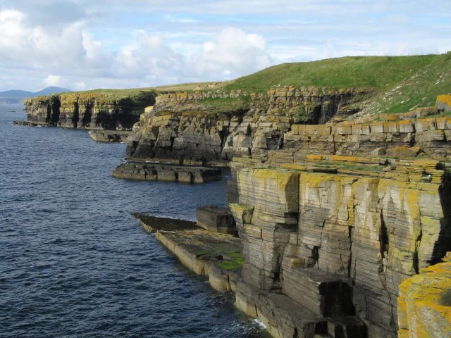
Rugged, layered sandstone cliffs along a coastline, with green grassy slopes above and dark blue ocean water below.
Weathered sandstone cliffs meeting the North Sea at Mid Clyth.

East Caithness Cliffs history and protected-area timeline

The East Caithness Cliffs gained formal conservation recognition through a progressive layering of designations beginning in the mid-1990s. The Special Protection Area, the broadest of the three main designations and the one that gives the protected landscape its commonly used title, was established in 1996. It was created to safeguard the cliffs and adjacent sea as a key breeding area for seabirds within the European Natura framework.

Earlier and subsequent SSSI designations, including Castle of Old Wick to Craig Hammel, Craig Hammel to Sgaps Geo, Dunbeath to Sgaps Geo, Berriedale Cliffs, Ousdale Burn, and Helmsdale Coast, were brought into alignment with the SPA and later the land-based SAC and the marine MPA. The gradual build-up of these overlapping protections reflects how the site's value to seabirds, coastal plants, and marine wildlife was better understood over time, and how management responsibility evolved toward integrated coastal and marine conservation under NatureScot.

East Caithness Cliffs landscape and geographic character

The physical landscape of East Caithness Cliffs is defined by steep sandstone cliffs plunging down to the North Sea along the eastern edge of Caithness. The rocks are part of the Middle Old Red Sandstone succession typical of the area, and the cliffs reach their highest point of about 150 metres near Berriedale. Differential erosion has cut the lower cliff into segmented bays, headlands, and small geos, and wave action continues to notch out sea caves at the base of the most exposed sections.

Above the cliff edge, the terrain is a mix of sloping maritime heath, rough grassland, and peat-stained hollows, with occasional freshwater flushes running down toward the cliff face. Inland from the cliff lip, the ground gradually levels out into the wider Caithness plain, although much of this hinterland lies outside the formal protected boundary. Small beaches of cobble and weathered rock debris collect at the foot of the cliffs, particularly in the bays south of Wick.

East Caithness Cliffs ecosystems, habitats, and plant life

Ecologically, East Caithness Cliffs represent a classic North Sea sandstone-coast system where seabird cliffs grade upward into maritime heath, grassland, saltmarsh fragments, and sheltered scrub. The cliffs provide nesting ledges, crevices, boulder scree, and burrow sites for a wide range of cliff-nesting seabirds, while the cliff tops add botanical richness through thin maritime soils that support specialist plants.

The protected zone also incorporates small pockets of saltmarsh, especially near stream mouths, where saltmarsh rush and a small suite of herbaceous halophytes grow. Ungrazed cliff-top grassland and heathland host flowering species that benefit from controlled light grazing, while more moderate microclimates in the southern gullies have allowed juniper, willow, hazel, hawthorn, and aspen scrub to develop. Compared with the bare, hyper-exposed cliffs at Cape Wrath or the Hebrides, East Caithness Cliffs have a relatively more vegetated profile, lending them broader botanical interest.

East Caithness Cliffs wildlife and species highlights

The wildlife profile of East Caithness Cliffs is dominated by breeding seabirds, which use the cliff face and boulder scree during spring and summer. Black guillemot is the site's signature species, with more than 1,500 individuals breeding on the cliffs and giving East Caithness the most important black guillemot colony on Scotland's east coast. Common guillemot, razorbill, and black-legged kittiwake are present in large, tightly packed colonies on the broader cliff ledges, while shag and cormorant favour the lower rock crevices near the sea.

Larger gull species also breed here in significant numbers, with herring gull and great black-backed gull both nesting around the cliffs and cliff tops. Northern fulmar is present in smaller but widely distributed numbers, occupying grassy ledges and small overhangs. Together these species are estimated to produce a peak seasonal population of up to 300,000 seabirds on and around the cliffs, making it one of the densest breeding seabird aggregations on the Scottish mainland.

East Caithness Cliffs conservation status and protection priorities

From a conservation perspective, East Caithness Cliffs is a textbook example of stacked, complementary site protection. The Special Area of Conservation safeguards the cliff habitats and their associated vegetation, the offshore Marine Protected Area extends protection two kilometres out to sea to cover the marine environment the seabirds feed over, and the Special Protection Area merges the two for bird-focused protection. Combined with six underlying SSSIs, the result is one of the most comprehensively designated coastlines in Scotland.

The management approach recognises that the cliffs depend on subtle balances of disturbance, grazing, and vegetation control. Light grazing of cliff-top grassland and heath is actively encouraged because it allows plants to flower and set seed while reducing overgrowth, but managed muirburn is strongly discouraged because it can damage some of the more slow-growing maritime plant communities. Bracken is treated as a threat and actively prevented from establishing, both because it shades out native flora and because it reduces the open structure that many cliff-top plants and ground-nesting birds depend on.

Top sights and standout views in East Caithness Cliffs

The defining highlights of East Caithness Cliffs are the towering sandstone cliff face at Berriedale; the up to 300,000-strong seabird breeding season; the most important black guillemot colony on Scotland's east coast; the layered SAC, MPA, and SPA conservation architecture; and the unusual botanical mix of maritime heath, saltmarsh fragments, and southern juniper-willow scrub at the top of the cliffs.
Monthly climate preview

Long term representative measurements and monthly weather rhythm for East Caithness Cliffs

East Caithness Cliffs Climate Normals, Annual Temperature and Precipitation

Representative coordinate records show monthly average temperatures ranging from 4.84 degrees Celsius to 13.63 degrees Celsius alongside recorded precipitation values between 2.08 and 3.73 millimeters per day. Examining the complete twelve month climate profile reveals full seasonal progression patterns across the protected landscape.
Annual mean9 °C
5 °C14 °C
Jan
Feb
Mar
Apr
May
Jun11°
Jul13°
Aug14°
Sep12°
Oct10°
Nov
Dec
Warmest month
August

13.6 °C

Coolest month
February

4.8 °C

Wettest month
October

3.7 mm/day

Driest month
May

2.1 mm/day

Park location guide

Geography guide, regional context, and park location map for East Caithness Cliffs

East Caithness Cliffs park geography, regions, and map view in United Kingdom

Understand where East Caithness Cliffs sits in United Kingdom through a broader geographic reading of the surrounding landscape, nearby location context, and its mapped position within the national park landscape.

How East Caithness Cliffs fits into United Kingdom

The United Kingdom is a parliamentary constitutional monarchy located in northwestern Europe, consisting of four constituent countries: England, Scotland, Wales, and Northern Ireland. As a major global power with over 69 million residents, it maintains significant international influence in politics, economics, and culture.

Wider geography shaping East Caithness Cliffs in United Kingdom

The United Kingdom is an island nation located in northwestern Europe, surrounded by the Atlantic Ocean, North Sea, English Channel, Celtic Sea, and Irish Sea. It shares a land border with the Republic of Ireland to the west. The territory includes the island of Great Britain, the northeastern portion of Ireland, and most of the smaller British Isles islands.

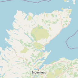
Map view of East Caithness Cliffs

Use this park location map to pinpoint East Caithness Cliffs in United Kingdom, understand its exact geographic position, and read its mapped placement within the surrounding landscape more clearly.

Pigeon | © OpenStreetMap contributors

Location context for East Caithness Cliffs

Scotland

Visual reference for sandstone sea cliffs, coastal heath, and nesting seabird habitats

East Caithness Cliffs Photos and Protected Landscape Scenery

Visual records reveal the dramatic sandstone geology and weather-beaten terrain defining East Caithness Cliffs along the North Sea. Photographic exploration highlights the rugged nesting ledges, maritime vegetation, and coastal habitats supporting hundreds of thousands of breeding seabirds.

Rugged, layered sandstone cliffs along a coastline, with green grassy slopes above and dark blue ocean water below.

Park atlas

Compare regional geography, sandstone cliffs, and connected marine protected areas

Explore Other Parks Near East Caithness Cliffs and Protected Coastal Landscapes

Browse nearby national parks and protected areas to compare coastal terrain, wildlife habitats, and regional geography beyond East Caithness Cliffs. Expanding the regional view connects individual coastal sanctuaries to wider protected landscapes across northern Scotland.
A minimalist, stylized vector illustration of coastal cliffs meeting the sea, with a lighthouse visible in the distance on top of the headland.
Marine protected areaHighland
About 5.3 km away#1 closest

Northeast

Noss Head Marine Protected Area: Highland Coastal and Benthic Geography

Exploring the rocky cliffs and offshore mussel habitats of Northern Scotland.

Noss Head is a notable marine protected area located on the Caithness coast of the Scottish Highlands. The site is defined by its rugged coastal cliffs and an expansive, nationally important horse mussel bed that occupies the seabed at depths between 35 and 45 metres. This area represents a core study in North Atlantic benthic ecology and dramatic maritime landforms.

Area
8 km²
Established
2014
IUCN
IV
Relief
Lowland
A watercolor painting showing a wide, sweeping landscape of green hills, a winding stream, and flat boggy terrain under a soft, light-colored sky.
Nature reserveScotland
About 23 km away#2 closest

Northwest

Flow Country: Geography and Protected Landscape Analysis of Scotland's Blanket Bog

Northern Scotland's vast, waterlogged peatland ecosystem.

The Flow Country is defined by its extensive, open peatland terrain stretching across Caithness and Sutherland. This nature reserve serves as a critical geographic study area for understanding blanket bog formation, carbon storage, and the restoration of fragile wetland habitats in northern Europe.

Area
4,000 km²
Relief
Lowland
Scope
Terrestrial
Water
Water-dominated
Watercolor painting of soft rolling dunes, green hills, and light clouds.
Protected areaSutherland
About 31 km away#3 closest

Southwest

Coul Links Protected Area: Coastal Dune and Heathland Geography in Sutherland, Scotland

A study of coastal dune succession and wetland terrain

Coul Links serves as a quintessential example of a Scottish coastal links landscape, tracing a continuous path from active beach fronts through to stable, juniper-rich heathland. Situated in Sutherland, the site offers a window into the formation of dune slacks, seasonal freshwater lochans, and the ecological dynamics of a complex, interwoven coastal system.

Relief
Lowland
Climate
Temperate
Access
Easy access
Scope
Terrestrial
Watercolor painting depicting mountains, forested hills, and a river in a scenic landscape
National parkScotland
78 km away#4 closest

South

Cairngorms National Park: Explore Scotland's Largest Protected Mountain Landscape

Mapped boundaries and arctic-alpine geography.

As the United Kingdom's largest national park, Cairngorms National Park in Scotland presents a vast expanse of distinctive arctic-alpine terrain and ancient Caledonian forests. This protected landscape offers a unique opportunity to explore mapped geographic features, from its extensive mountain plateaus to its vital river systems. Discover the contours and context of this significant natural area within the broader atlas of Scotland's protected lands.

Area
4,528 km²
Established
2003
IUCN
V
Visitors
1.9M annual
Wildlife reserveOrkney
79 km away#5 closest

North

Rousay Wildlife Reserve: Mapped Geography and Protected Landscapes in the Orkney Archipelago

Island moorlands, coastal cliffs, and freshwater loch ecosystems.

Rousay represents a critical protected area within the Orkney islands, characterized by its elevated moorland summits and dramatic shorelines. The mapped terrain reveals complex interactions between marine sounds and terrestrial habitats, offering a deep look into the regional geography and conservation status of this northern sanctuary.

Area
48.6 km²
Relief
Upland
Climate
Temperate
Access
Moderate access
A wide watercolor illustration showing a mountain range in the distance, a valley, and green forests on either side, with soft pastel colors.
Protected landscapeHighland
About 80 km away#6 closest

West

North West Sutherland National Scenic Area: Mapping the Peaks and Coasts of Highland Scotland

Protected quartzite mountain landscapes and Atlantic coastal geography

This detailed overview of the North West Sutherland National Scenic Area maps the dramatic interplay between the white quartzite mountains of Foinaven and Arkle and the darker Lewisian gneiss that forms the underlying Highland landscape. The analysis provides deep insights into the region's knock and lochan topography, sea lochs, and the protected coastal habitats of Handa Island, anchoring the area within its broader Scottish geological context.

Area
266 km²
Established
1981
Relief
Mountain
Climate
Temperate
Protected landscapeHighland
About 107 km away#7 closest

Southwest

Wester Ross National Scenic Area: Protected Highland Mountain and Coastal Landscape Atlas

Geographic mapping of the Northwest Highlands terrain

Wester Ross National Scenic Area spans vast stretches of the Northwest Highlands, characterized by towering Torridonian sandstone peaks and deeply carved sea lochs. This protected region integrates ancient Scots pine forests, glacial-carved glens, and complex coastal environments into one of the most recognizable geographic features of Scotland. The landscape serves as a vital record of geological heritage and high-latitude biodiversity within the Highland administrative region.

Area
1,634.58 km²
Established
1981
Visitors
70K annual
Relief
Mountain
A soft, impressionistic watercolor painting of a Scottish loch surrounded by rolling green hills and distant mountain silhouettes.
Marine protected areaRoss and Cromarty
About 140 km away#8 closest

Southwest

Loch Carron Marine Protected Area: Coastal Geography and Protected Seabed Landscape Atlas

Exploring the tidal basins and underwater terrain of Ross and Cromarty.

Loch Carron stands as a landmark marine protected area defined by its dramatic underwater depth changes and robust tidal currents. This protected sea loch features the world's largest flame shell colony nestled beneath the cliffs at Strome Castle. The surrounding Highland geography of Ross and Cromarty creates a compressed, mountain-framed landscape that influences the rich ecological character of this essential coastal habitat.

Area
23 km²
Established
2019
Relief
Lowland
Climate
Temperate

Common questions about visiting, size, designation, and location context for East Caithness Cliffs

East Caithness Cliffs FAQs for park facts, access, geography, and protected area context

Find quick answers about East Caithness Cliffs, including protected-area facts, park geography, trail and visitor context, and how the park fits into its surrounding country and regional landscape.
MoriAtlas Explorer

Continue Your Protected Areas Search Across the Global Atlas

Deepen your exploration by continuing the structured search for national parks and protected areas worldwide. Utilize the comprehensive filtering capabilities to compare different conservation landscapes and refine your understanding of global park geography. Discover more about the distribution and characteristics of protected natural areas.

Global natural geography