
Why Moutere Hauriri / Bounty Islands Marine Reserve stands out
The reserve is best known for protecting the Bounty Islands, a tiny cluster of granite rocks that hosts one of the largest New Zealand fur seal colonies in Australasia and extraordinarily dense breeding populations of seabirds. The clarity of the surrounding water, with underwater visibility reaching up to forty meters, makes the area ecologically significant not only for the wildlife on the rocks but also for the unusual reef communities living around them. The combination of a barren, lifeless-looking land surface and a hugely productive marine environment gives the place a striking identity within New Zealand's protected areas network.
Moutere Hauriri / Bounty Islands Marine Reserve history and protected-area timeline
The European discovery of the islands is tied to a famous voyage of exploration. The English name Bounty comes from the ship commanded by William Bligh when the islands were first recorded by Europeans in 1788. The Māori name, Moutere Hauriri, by contrast reflects long awareness of these waters and translates roughly as "island of angry wind," capturing the rough seas that are a defining feature of the area.
The marine reserve itself is a much more recent addition to New Zealand's protected areas history. The legal framework for the reserve was initiated in 2011, when a law change was introduced to Parliament to enable its creation. The reserve was proposed in 2012 and given formal legal status on 4 March 2014. It was created alongside the Moutere Mahue / Antipodes Island Marine Reserve and Moutere Ihupuku / Campbell Island Marine Reserve as part of the same legislative package, extending marine protection across New Zealand's subantarctic island territories.
Moutere Hauriri / Bounty Islands Marine Reserve landscape and geographic character
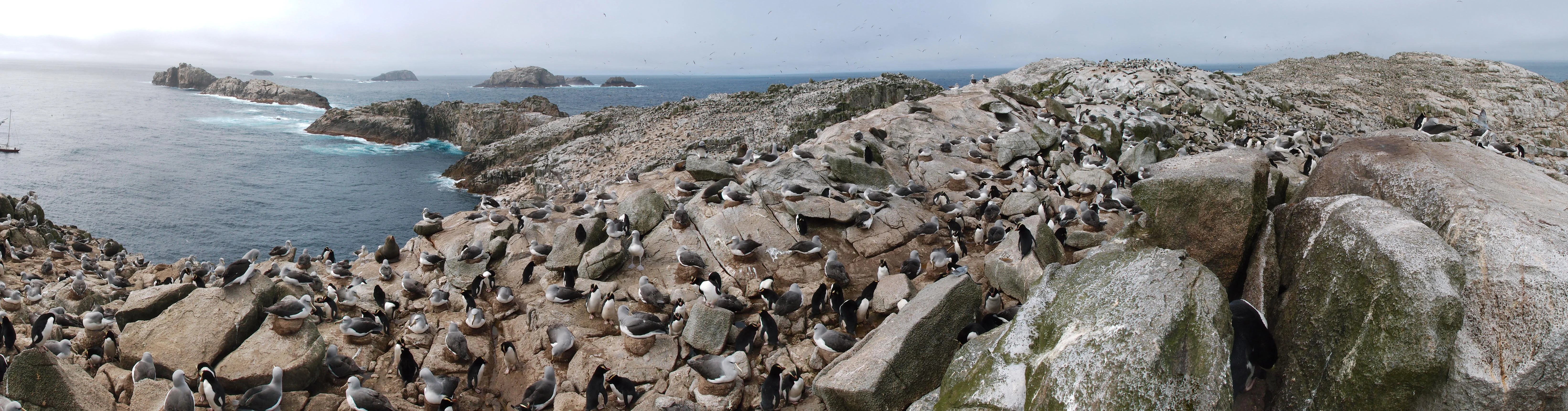
The landscape of the reserve is dominated by absence rather than abundance of terrestrial features. The Bounty Islands consist of about twenty small islets and rocks, all carved from Early Jurassic granite. There is no soil and no native vegetation on the islands themselves, leaving only exposed, weathered stone surfaces that give the archipelago a stark, almost sculptural appearance against the Southern Ocean.
The marine landscape around the islands is equally distinctive. The water is unusually clear for such a remote southern location, with visibility reported at up to forty metres. Rocky reef communities surround the islands, with steep and irregular underwater terrain shaped by the same granite that forms the land above. The wider seascape is open ocean, open to the long fetch of the Southern Ocean and exposed to the persistent winds that gave the islands their Māori name.
Moutere Hauriri / Bounty Islands Marine Reserve ecosystems, habitats, and plant life
Although the islands themselves are largely devoid of terrestrial vegetation, the habitats around and above them are ecologically intense. The bare granite surfaces are coated in a thick layer of guano, a biological legacy of the dense seabird breeding colonies that occupy the islands seasonally. This nutrient-rich substrate supports communities of insects and other small invertebrates, including beetles, wētā, and flightless moths that have evolved to inhabit this unusual, guano-dependent environment.
Below the waterline, the granite reefs host rich and colorful biological communities. Brightly colored sponges, large mussels, and barnacles encrust the rocky surfaces, while sea sponges and shellfish inhabit the spaces beneath. The ecological character of the marine environment has been compared with ecosystems much further north and closer to the equator, such as the Galápagos Islands and Puget Sound, due to the unusual diversity of species encountered in these cool but clear waters.
Moutere Hauriri / Bounty Islands Marine Reserve wildlife and species highlights
The Bounty Islands support some of the most concentrated wildlife aggregations in the New Zealand region. New Zealand fur seals are one of the reserve's most prominent inhabitants, with the island group described as home to the world's largest colony of the species, numbering in the tens of thousands of individuals.
Seabirds are equally prolific during the breeding season. The islands host very large breeding populations, on the order of thirty thousand pairs each, of Salvin's mollymawks, erect-crested penguins, and fulmar prions, along with several hundred pairs of the Bounty Island shag, a species closely associated with this archipelago. During the height of the summer breeding season the islands can be heard and smelled from a considerable distance because of the sheer density of animals present.
The surrounding ocean is also rich in mobile wildlife, including giant spider crabs and giant masking crabs, individuals of which have been recorded with leg spans reaching around a meter. This combination of crowded terrestrial breeding colonies and unusual reef-dwelling invertebrates gives the reserve a wildlife profile almost without parallel within New Zealand's protected areas.
Moutere Hauriri / Bounty Islands Marine Reserve conservation status and protection priorities
Conservation of the Bounty Islands is fundamentally about protecting one of the New Zealand region's most undisturbed subantarctic marine ecosystems. By placing roughly 104,626 hectares of surrounding ocean under marine reserve status from 2014 onward, the country ensured that the seabird colonies, fur seal populations, and reef communities around the islands were shielded from the most damaging forms of human activity. All fishing and landing within the reserve are prohibited, with permits for any landing issued only under strict minimum-impact conditions.
Beyond the reserve itself, protection extends into the adjacent territorial sea, which is designated as a type 2 marine protected area. In this zone, bottom-disturbing fishing practices such as bottom trawling, Danish seining, and dredging are explicitly banned, extending a buffer of seabed protection around the reserve. Quarantine measures apply to any permitted visits, reflecting concern about introducing alien species or diseases to one of New Zealand's most pristine island environments.
Because the islands lie more than 700 kilometers from the South Island, the reserve also represents a strategic investment in protecting the connectivity and integrity of New Zealand's broader subantarctic and Southern Ocean ecosystems, alongside the Antipodes and Campbell Island marine reserves created under the same process.
Moutere Hauriri / Bounty Islands Marine Reserve cultural meaning and human context
The dual name of the reserve reflects the layered cultural and historical significance of the place. The Māori name Moutere Hauriri, meaning roughly "island of angry wind," indicates long Māori awareness of these far-flung islands and the harsh conditions surrounding them. The English name Bounty, drawn from the vessel under William Bligh's command during the islands' first European sighting in 1788, reflects the European exploration history of the late eighteenth century.
Together, the two names acknowledge that the islands have a place both in Māori environmental knowledge of the southern seas and in the wider narrative of Pacific exploration, without privileging one tradition over the other.
Top sights and standout views in Moutere Hauriri / Bounty Islands Marine Reserve
The reserve's standout qualities include the global significance of its New Zealand fur seal colony, which is described as the largest in the species' range, and the staggering density of breeding seabirds such as Salvin's mollymawks, erect-crested penguins, fulmar prions, and Bounty Island shags. The exceptional clarity of the surrounding water, with submarine visibility up to forty meters, also makes it ecologically notable, supporting reef communities and large crab species that are unusual for subantarctic latitudes.
Best time to visit Moutere Hauriri / Bounty Islands Marine Reserve
Any visit to the reserve is shaped primarily by the harsh Southern Ocean environment rather than by conventional travel seasons. The summer breeding period is when the islands are most biologically active, with fur seals hauling out in large numbers and seabirds forming dense nesting aggregations that fill the rocks with noise and scent. Access remains exceptionally difficult year round, with safe navigation through the islands only possible about one day in four, and landings only by special permit.
For those simply passing through by cruise vessel, calm weather windows are the most important factor, making the relatively milder subantarctic summer months the most practical, though far from guaranteed, time to experience conditions at their least severe.