
Mori Atlas logo
Nature reservePeel Forest Park

Exploring the botanical significance and rugged mountain-to-plain transition of this New Zealand forest reserve.

Peel Forest Park Nature Reserve: Mapped Protected Landscapes and Canterbury Foot-hills Geography

(Peel Forest Park Scenic Reserve)

Peel Forest Park serves as a vital protected remnant of lowland podocarp forest within the Canterbury region of New Zealand. Situated in the foothills beneath the Southern Alps and adjacent to the Rangitata River, this reserve provides a window into the classic forest composition of matai, totara, and kahikatea trees. The site offers a layered topography that connects river-influenced lowlands to the rising slopes of Mount Peel, illustrating the transition between the plains and alpine peaks.

podocarp forestscenic reserveSouthern Alps foothillsnative bushkahikatea forestlowland forest
A flat style digital illustration of a green mountain valley with pine trees, steep cliffs, a distant waterfall, and a bright sun in a blue sky with soft clouds.

Peel Forest Park

Nature reserve

Park overview

Structured park overview, official facts, and landscape profile for Peel Forest Park

Peel Forest Park park facts, protected area profile, and essential visitor context

Review the core facts for Peel Forest Park, including designation, size, terrain, visitor scale, habitats, and operating context in one park-focused overview.

About Peel Forest Park

Peel Forest Park is a small but ecologically significant protected forest in the inland Canterbury region of New Zealand's South Island. It sits in the foothills of the Southern Alps, close to the Rangitata River and the Mount Peel massif, and is administered by the Department of Conservation as a scenic reserve rather than as a forest park in the formal New Zealand sense. Its roughly 769 hectares preserve one of the regional fragments of the original Canterbury podocarp forests, which were once far more extensive across the lowlands and lower mountain slopes of the area.

The forest owes much of its ecological character to its location along the moist, sheltered foothills west of the Canterbury Plains. The combination of Southern Alpine rain shadow edges, river valleys, and elevation transitions creates conditions that have supported a tall, mixed podocarp forest, with kahikatea, tōtara, and mataī as the three core species. Over time, logging reduced what was once a much larger forest cover to its current compact reserve, and the area has since been managed to maintain and restore the surviving native bush.

Beyond its ecological role, Peel Forest Park is woven into the wider cultural and historical fabric of inland Canterbury. It lies near the small settlement of Peel Forest and is surrounded by farmland that was settled in the mid-19th century. The name of the forest itself comes from Francis Jollie, who named the area after the British Prime Minister Sir Robert Peel in the early years of the Canterbury settlement. In the early 20th century, the area drew scientific attention when the botanist Harry Allan undertook extensive fieldwork around Mount Peel, contributing to the foundational documentation of New Zealand's flora.

Today, the reserve functions as both a conservation site and a recreational gateway into the surrounding hill country. Walking tracks lead through the bush and up into the surrounding ridges, and views of the broader Southern Alps frame the forest in a visually striking landscape. Although it is modest in size, Peel Forest Park is widely valued in regional conservation and outdoor recreation circles as an accessible example of Canterbury's indigenous forest heritage.

Quick facts and research context for Peel Forest Park

Peel Forest Park is a Department of Conservation scenic reserve of roughly 769 hectares (about 1,900 acres) in inland Canterbury, on the South Island of New Zealand. It lies in the foothills of the Southern Alps near the Rangitata River and is reached from the nearby town of Geraldine. The reserve was created in 1909 and protects a remnant podocarp forest that includes kahikatea, tōtara, and mataī. It is also known historically for the early botanical research carried out by Harry Allan on nearby Mount Peel.

Protection and recognition

Documented terrestrial protection scope and international recognition facts

Peel Forest Park Protection Status and Conservation Designations

Terrestrial protection status and administrative parameters define the legal standing of Peel Forest Park within regional conservation networks. Documented protection metrics outline the operational framework and official management scope assigned to this protected natural area.

Protection details

Protection scope
Terrestrial
Transboundary protection
No
Park context

Deeper park guide and search-rich context for Peel Forest Park

Peel Forest Park history, landscape, wildlife, and travel context

Explore Peel Forest Park through its history, landscape character, ecosystems, wildlife, conservation priorities, cultural context, and seasonal travel timing in a structured park guide built for atlas discovery and search intent.

Why Peel Forest Park stands out

Peel Forest Park is best known for being a surviving remnant of the once extensive podocarp forests that flourished in the Canterbury foothills. Its three dominant tree species, kahikatea (white pine), tōtara, and mataī (black pine), represent a classic New Zealand lowland and lower-montane forest composition that has otherwise been heavily reduced through logging and land clearance. The reserve is also recognized for its association with early New Zealand botanical science, most notably Dr. Harry Allan's work on the Mount Peel forests, and its scenic setting in the rolling foothills beneath the Southern Alps. Together, these botanical, scientific, and landscape qualities give the park a distinctive profile among Canterbury's protected natural areas.
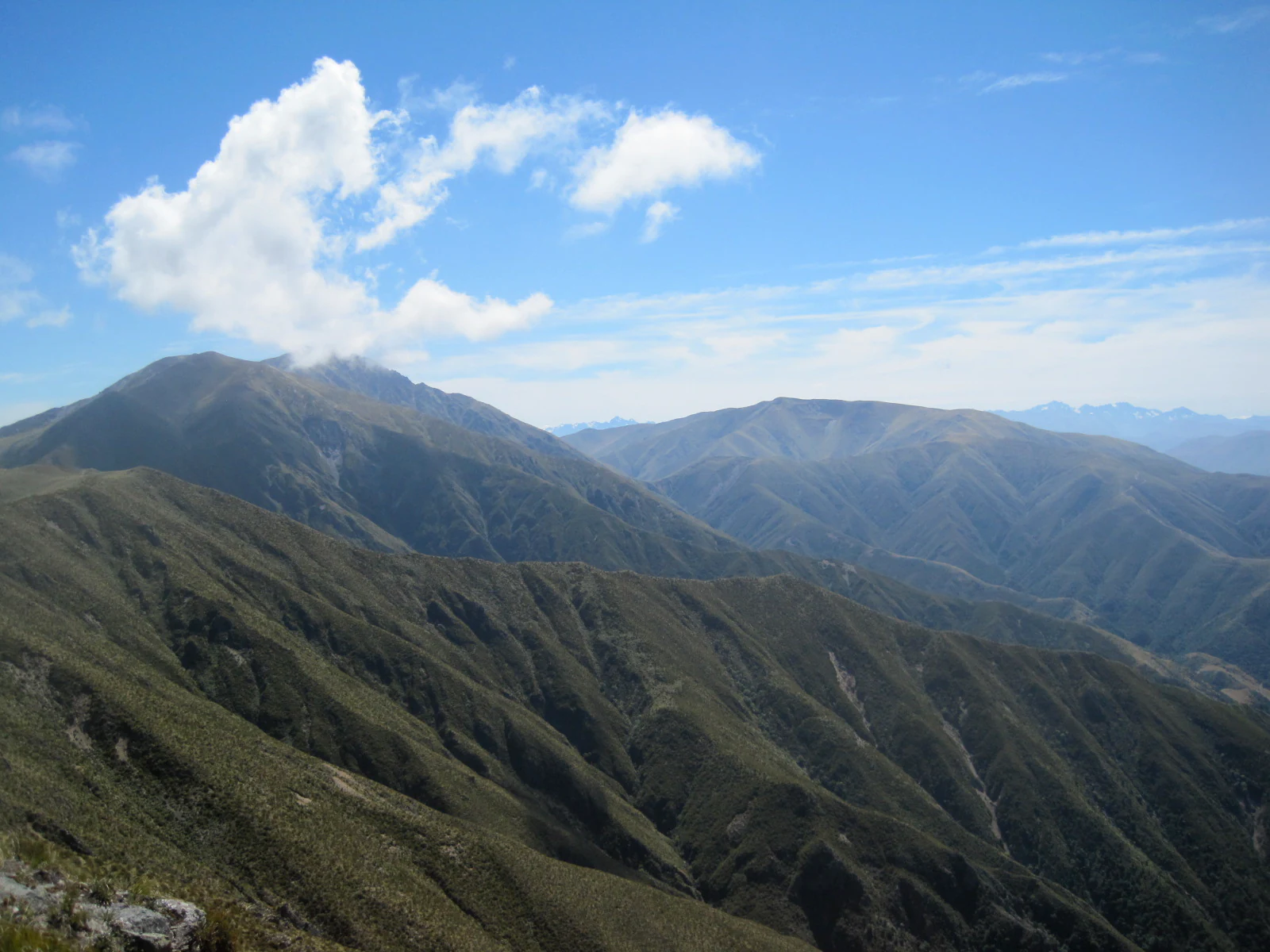
A wide mountain landscape under a bright blue sky with a few white clouds, showing rolling, vegetation-covered mountain slopes.
A scenic view of the mountain ranges, including Mount Peel, as seen from Little Mount Peel in Peel Forest Park.

Peel Forest Park history and protected-area timeline

The forest that gives Peel Forest Park its name was christened by Francis Jollie, a settler who arrived in the area in late 1853. Jollie named it in honor of Sir Robert Peel, the British Prime Minister who had died in 1850, the same year that the Canterbury settlement was founded. The nearby Mount Peel and the small community of Peel Forest later took the same name.

Over the late 19th and early 20th centuries, the surrounding podocarp forest was progressively reduced by logging, leaving only a remnant of what had originally been a very extensive forest cover. In recognition of its remaining ecological and scenic values, the area was formally established as a scenic reserve in 1909, becoming one of the earlier dedicated forest reserves in the Canterbury region.

The park is also notable in the history of New Zealand botanical science. Dr. Harry Allan undertook a major botanical study of the Mount Peel forests, and the resulting work earned him a Doctor of Science degree in 1923. Since then, the reserve has continued to be managed by the Department of Conservation as a protected area, with a focus on preserving its native flora and maintaining public access through a network of walking tracks.

Peel Forest Park landscape and geographic character

The landscape of Peel Forest Park reflects its position in the transition zone between the flat Canterbury Plains and the steep eastern flanks of the Southern Alps. The reserve lies among rolling, bush-covered foothills close to the Rangitata River, with the higher and more rugged peaks of Mount Peel and Little Mount Peel rising above it. This setting gives the park a layered topography, from gentle river-influenced lowlands through forested slopes to open ridgelines and alpine summits nearby.

Within the reserve itself, the terrain is shaped by river valleys and dissected hill country, with the native forest filling gullies, slopes, and ridges. The surrounding lands are a mix of pasture and regenerating bush, creating a patchwork of agricultural and forested landscapes typical of inland Canterbury. From many points in the park, the views open out across the Canterbury Plains to the east and toward the crests of the Southern Alps to the west, giving visitors a strong sense of being in a transitional landscape between mountain and plain.

Peel Forest Park ecosystems, habitats, and plant life

Peel Forest Park protects an ecologically important example of New Zealand's podocarp forest, a vegetation type that has become increasingly rare in the lowlands and lower foothills of Canterbury. The reserve's forest composition is dominated by three characteristic podocarp species: kahikatea (white pine), tōtara, and mataī (black pine), which grow together in a mixed canopy structure typical of older New Zealand lowland forest.

Beyond the dominant podocarps, the reserve supports a layered understory of smaller native trees, shrubs, ferns, and ground plants typical of mature New Zealand bush. The mix of riverine influence, varying slope aspects, and elevation within the reserve contributes to habitat diversity across a relatively small area. This ecological richness makes the park valuable both for conservation of indigenous forest communities and for visitors interested in experiencing a representative example of pre-clearance Canterbury bush.

Peel Forest Park wildlife and species highlights

The forest at Peel Forest Park supports a characteristic range of native New Zealand bush birds. Frequent species include the kererū (New Zealand pigeon), the fantail (pīwakawaka), and the tomtit (miromiro), all of which are commonly encountered by visitors walking through the reserve. These species are typical inhabitants of mature podocarp and broadleaf forest in the South Island, and their continued presence indicates that the reserve maintains good native habitat quality.

The wider foothills around the park also provide habitat for other forest and edge species, as well as birds of prey that range over the surrounding farmland and hill country. While the reserve is not primarily known for large or charismatic megafauna, its birdlife is a key part of the visitor experience and an important indicator of the ongoing ecological health of the forest.

Peel Forest Park conservation status and protection priorities

From a conservation perspective, Peel Forest Park matters primarily because it protects a surviving fragment of Canterbury's original podocarp forest in a region where such forest has been heavily reduced by clearance and logging. The combination of kahikatea, tōtara, and mataī in a single reserve represents a forest type that is otherwise poorly represented in the modern Canterbury landscape.

The reserve's formal protection since 1909 has allowed the remaining forest to mature and regenerate, and its ongoing management by the Department of Conservation continues that work. The park also serves an educational and scientific role, both as a living example of indigenous forest ecology and as a place connected to the early botanical surveys of inland Canterbury, including Harry Allan's foundational studies of Mount Peel.

Peel Forest Park cultural meaning and human context

The cultural context of Peel Forest Park is closely tied to the early colonial history of inland Canterbury. The forest, the surrounding settlement, and the adjacent mountain all carry the name of Sir Robert Peel, the British Prime Minister who died in 1850, the founding year of the Canterbury settlement. The naming was done by Francis Jollie, one of the early European settlers in the district, in the early 1850s.

The area also has a notable place in New Zealand botanical history. The botanist Harry Allan carried out detailed work on the Mount Peel forests in the early 20th century, contributing foundational knowledge of the region's indigenous flora and earning an advanced degree for his research. Together, the early settlement history and the area's scientific heritage give the park a cultural depth beyond its ecological role.

Top sights and standout views in Peel Forest Park

Peel Forest Park stands out as one of the better-preserved lowland podocarp forest remnants in inland Canterbury, with mature stands of kahikatea, tōtara, and mataī forming the backbone of the reserve. The dramatic setting beneath the Mount Peel massif and along the upper Rangitata valley gives it strong visual appeal, and the surrounding foothills connect the park to the wider Southern Alps landscape.

Equally distinctive is the reserve's role in the history of New Zealand botanical science, particularly through Harry Allan's work. The combination of accessible native bush, a network of established walking tracks, and a setting that links forest to mountains and plains makes Peel Forest Park especially rewarding as both a conservation site and a place to experience classic Canterbury scenery.

Best time to visit Peel Forest Park

The park's character changes with the seasons in ways typical of inland Canterbury. Summer brings the most settled weather and the easiest walking conditions, with longer days allowing fuller exploration of the bush tracks and the climb up Little Mount Peel. Spring and autumn are also attractive periods, with cooler temperatures and the seasonal interest of flowering and fruiting native plants in the forest understory.

Winter can bring colder temperatures, frost, and occasional snow to the higher ridges, which can affect access to some of the steeper or more exposed tracks but also creates a quieter, more atmospheric visit to the lower-elevation forest. For those primarily interested in native forest and birdlife any season, the sheltered lower trails remain rewarding, while visitors seeking combined forest and mountain views typically find late spring through autumn the most comfortable window.
Monthly climate preview

Long-term monthly temperature averages and precipitation patterns for Peel Forest Park

Peel Forest Park Climate Normals, Annual Temperature and Precipitation Rhythm

Representative coordinate records show measured annual temperature ranges and steady monthly precipitation patterns across the protected landscape. Examining the complete twelve-month climatology profile reveals deeper month-by-month temperature shifts and baseline precipitation data.
Annual mean10 °C
4 °C16 °C
Jan16°
Feb16°
Mar13°
Apr10°
May
Jun
Jul
Aug
Sep
Oct
Nov11°
Dec14°
Warmest month
January

15.7 °C

Coolest month
July

3.9 °C

Wettest month
December

2.6 mm/day

Driest month
September

2 mm/day

Park location guide

Geography guide, regional context, and park location map for Peel Forest Park

Peel Forest Park park geography, regions, and map view in New Zealand

Understand where Peel Forest Park sits in New Zealand through a broader geographic reading of the surrounding landscape, nearby location context, and its mapped position within the national park landscape.

How Peel Forest Park fits into New Zealand

New Zealand is an island nation in the southwestern Pacific Ocean comprising two main islands and numerous smaller islands. Located east of Australia across the Tasman Sea, it features varied topography with the Southern Alps running along the South Island and volcanic terrain on the North Island. The country was settled by Maori people between 1280 and 1350, followed by European exploration beginning in 1642, and became a Dominion in 1907 before gaining full independence in 1947.

Wider geography shaping Peel Forest Park in New Zealand

New Zealand lies in the southwestern Pacific Ocean, east of Australia across the Tasman Sea. The country consists of two main islands, the North Island and South Island, plus over 600 smaller islands. The North Island features volcanic plateaus and hills while the South Island is dominated by the Southern Alps mountain range. The country has a long coastline and is surrounded by the Pacific Ocean.

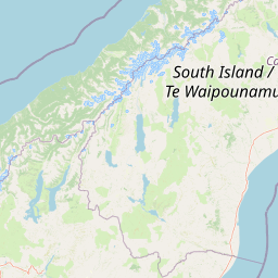
Map view of Peel Forest Park

Use this park location map to pinpoint Peel Forest Park in New Zealand, understand its exact geographic position, and read its mapped placement within the surrounding landscape more clearly.

Pigeon | © OpenStreetMap contributors

Examine the protected podocarp forest habitats and southern alps mountain terrain views.

Peel Forest Park Photos and Landscape Scenery Visual Exploration

Visual records illustrate the native podocarp forest canopy, mature kahikatea stands, and rolling foothill topography of Peel Forest Park. Photographic documentation reveals the environmental transition zone between the Canterbury plains and the alpine slopes of Mount Peel.

A wide mountain landscape under a bright blue sky with a few white clouds, showing rolling, vegetation-covered mountain slopes.

Park atlas

Compare regional geography, foothill reserves, and connected mountain terrain.

Explore Parks Near Peel Forest Park and Surrounding Protected Landscapes

Continue your protected-area research by discovering other regional reserves and foothill environments situated near Peel Forest Park. Expand your understanding of local conservation geography by comparing adjacent podocarp forests and surrounding mountain landscapes.
National parkCanterbury Region
About 68 km away#1 closest

West

Aoraki / Mount Cook National Park: New Zealand's Iconic Alpine Protected Landscape Exploration

Mapped glacial terrain and mountain peaks in the Canterbury Region.

Delve into the heart of New Zealand's alpine grandeur with Aoraki / Mount Cook National Park. This page offers an atlas-style exploration of its protected boundaries, dramatic glacial formations like the Tasman Glacier, and the towering peaks of the Southern Alps. Understand the park's significant geographic context within the Canterbury Region and discover the mapped landscape that defines this premier national park.

Area
707 km²
Established
1953
IUCN
II
Visitors
1M annual
National parkWest Coast
About 85 km away#2 closest

West

Westland Tai Poutini National Park: A Protected Landscape of Glaciers and Temperate Rainforests

Explore its mapped terrain and unique glacial features in West Coast, NZ.

Westland Tai Poutini National Park represents a remarkable intersection of glacial power and lush temperate rainforests along New Zealand's West Coast. As a protected national park, it showcases dramatic alpine scenery and the unique characteristic of glaciers descending to low elevations. Users can explore the mapped boundaries and the distinct natural landscapes that define this significant protected area, offering a clear view of its place within the region's geography.

Area
1,319.8 km²
Established
1960
IUCN
II
Relief
Mountain
A soft watercolor illustration featuring a panoramic view of rolling green hills, distant mountains, a meandering stream, and wildflowers in the foreground.
Protected landscapeSouth Island
About 91 km away#3 closest

Northeast

Craigieburn Forest Park: Protected Alpine Landscape and Southern Alps Geography

High country terrain from beech forests to alpine ridges.

Situated along the eastern flanks of the Southern Alps, Craigieburn Forest Park offers a complex mountain geography that serves as both a recreational hub and an ecological restoration zone. The area features a clear transition from beech-clad valley floors and glacial terraces to wide tussock basins and craggy summits, providing a detailed look at the diverse natural terrain of the Canterbury region.

Area
446.948 km²
Established
1967
Relief
Mountain
Climate
Alpine
National parkNew Zealand
About 95 km away#4 closest

North

Arthur's Pass National Park: Dramatic Alpine Protected Landscape in the Southern Alps

Explore the unique geography and mapped boundaries of this South Island national park.

Arthur's Pass National Park, a substantial protected area within New Zealand's Southern Alps, presents a compelling focus for geographic and atlas exploration. Characterized by dramatic alpine terrain shaped by ancient glacial forces, the park exhibits a striking ecological contrast between its drier eastern beech forests and wetter western rainforests. Users can delve into the mapped park boundaries and understand the regional landscape context of this unique protected area, making it a key destination for understanding New Zealand's natural geography.

Area
1,184.7 km²
Established
1929
IUCN
II
Relief
Mountain
Regional parkCanterbury Region
About 119 km away#5 closest

Northeast

Waimakariri River Regional Park: Geography and Protected Landscape Atlas for Canterbury

Braided river corridors and wetland habitats in the Canterbury Region

Waimakariri River Regional Park encompasses a significant managed corridor along the Waimakariri River, featuring an intricate mix of braided riverbeds, saltmarshes, and reforested land. This profile details the park topography, highlighting its role in regional flood management and its varied natural terrain across the Canterbury Plains, providing a clear geographic view of its multi-use protected boundaries.

Area
150 km²
Relief
Lowland
Access
Easy access
Scope
Terrestrial
National parkOtago
About 132 km away#6 closest

West

Mount Aspiring National Park: Glaciated Alpine Wilderness & Protected Landscape Atlas

Explore the U-shaped valleys and mapped boundaries of this iconic national park.

Mount Aspiring National Park showcases a breathtaking glacial landscape defined by steep-sided U-shaped valleys, active glaciers, and soaring alpine summits. As a designated national park within New Zealand's South Island, its protected status preserves a vast area of wilderness crucial for understanding regional geography and alpine terrain. This page provides an atlas-style exploration of its mapped boundaries and the stark, natural beauty that characterizes this significant conservation landscape in the Otago region.

Area
3,562 km²
Established
1964
IUCN
II
Relief
Mountain
A horizontal watercolor illustration depicting a coastal landscape with winding light-colored sandbars, pale water channels, and soft green rolling hills under a muted pastel sky.
Regional parkCanterbury Region
About 134 km away#7 closest

Northeast

Northern Pegasus Bay Regional Park: Canterbury Coastal Geography and Protected Land Atlas

Mapping the beaches, estuaries, and dunes of Northern Pegasus Bay.

Northern Pegasus Bay spans a long, curving stretch of the Canterbury coastline on New Zealand's South Island. This regional park protects a range of coastal landforms, including pebbly beaches, dune systems, and the regionally significant Ashley Rakahuri Estuary. The geography reflects a dynamic exchange of sediment across multiple river mouths, creating a distinct environmental corridor between coastal communities and the sea.

Relief
Lowland
Climate
Temperate
Access
Easy access
Scope
Mixed
A horizontal watercolor illustration showing a calm bay surrounded by rolling hills and soft greenery, with faint mountains in the background.
Marine protected areaNew Zealand
About 137 km away#8 closest

East

Akaroa Marine Reserve: Protected Harbour Geography and Marine Map

Volcanic coastal terrain and no-take zone boundaries

Located on the Banks Peninsula, Akaroa Marine Reserve represents a vital marine protected area within a deeply indented volcanic harbour. The reserve offers a unique look at the contrast between inner harbour mudflats and outer rocky reefs, serving as an essential case study for marine conservation and coastal geography in New Zealand.

Area
5.12 km²
Established
2014
IUCN
Ia
Relief
Lowland

Common questions about visiting, size, designation, and location context for Peel Forest Park

Peel Forest Park FAQs for park facts, access, geography, and protected area context

Find quick answers about Peel Forest Park, including protected-area facts, park geography, trail and visitor context, and how the park fits into its surrounding country and regional landscape.
MoriAtlas Explorer

Continue Your Protected Areas Search Across the Global Atlas

Deepen your exploration by continuing the structured search for national parks and protected areas worldwide. Utilize the comprehensive filtering capabilities to compare different conservation landscapes and refine your understanding of global park geography. Discover more about the distribution and characteristics of protected natural areas.

Global natural geography