
Mori Atlas logo
Wildlife reserveMuddy Mountains Wilderness

Examine the dramatic Aztec Sandstone cliffs and Mojave Desert topography within this federally designated wildlife reserve.

Muddy Mountains Wilderness: A Protected Desert Landscape and Rugged Terrain in Clark County

(Muddy Mountains Wilderness Area)

The Muddy Mountains Wilderness encompasses over 48,000 acres of intricate desert landscape defined by deeply eroded Aztec Sandstone ridges and narrow canyons. Situated east of Las Vegas in Clark County, this protected area features dramatic elevation changes and essential Mojave Desert habitat that extends toward the Lake Mead basin. The geographic character of the region is shaped by ancient sedimentary history, resulting in a complex, multi-layered terrain that serves as a vital refuge for rare flora and local wildlife populations.

wilderness areaMojave Desertdesert landscapeAztec Sandstonered rock scenerydesert wildlife
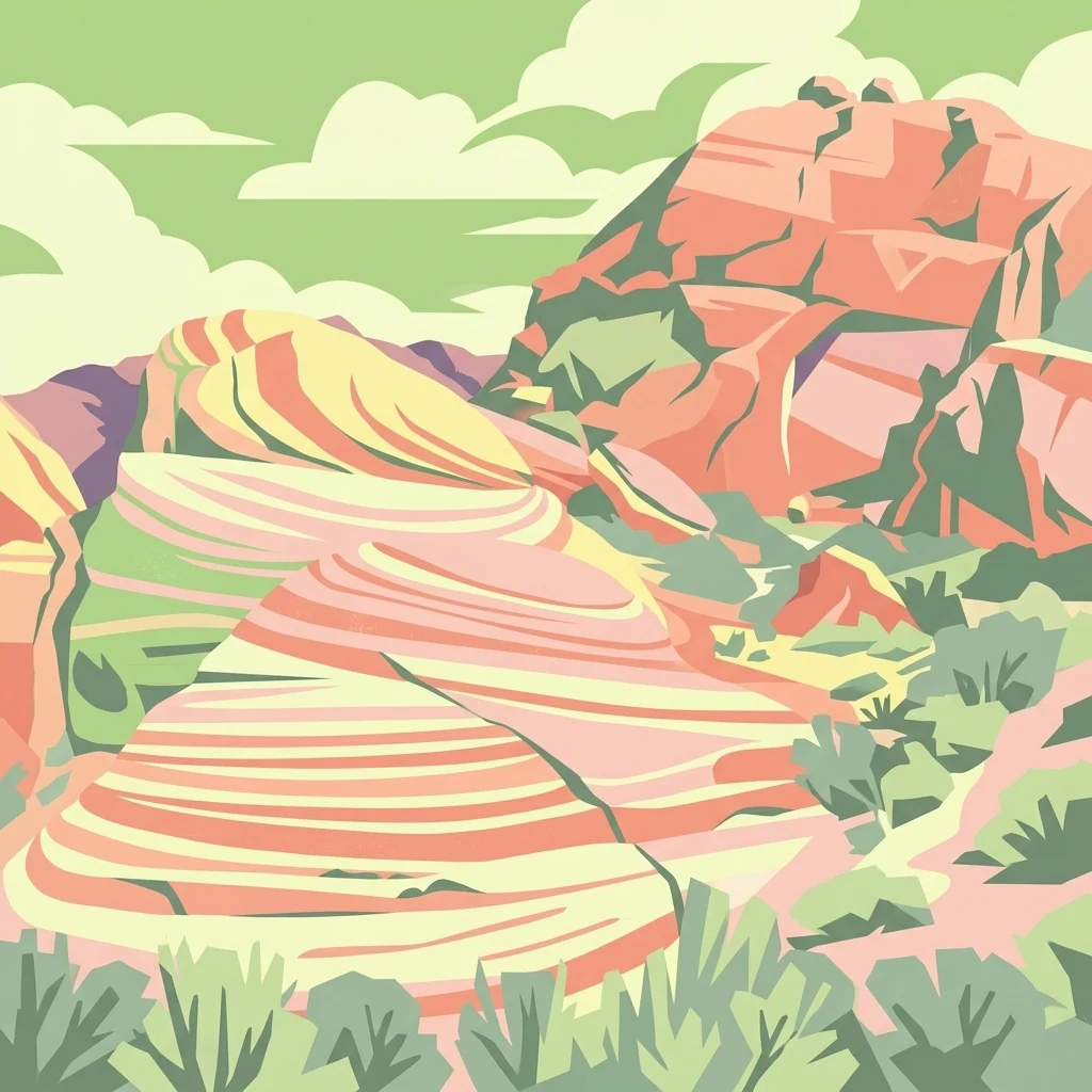
A graphic illustration of desert mountains with layered red and cream sandstone cliffs under a stylized sky.

Muddy Mountains Wilderness

Wildlife reserve

Park overview

Structured park overview, official facts, and landscape profile for Muddy Mountains Wilderness

Muddy Mountains Wilderness park facts, protected area profile, and essential visitor context

Review the core facts for Muddy Mountains Wilderness, including designation, size, terrain, visitor scale, habitats, and operating context in one park-focused overview.

About Muddy Mountains Wilderness

Muddy Mountains Wilderness preserves a striking expanse of eastern Mojave Desert scenery in southern Nevada, rising between the basins near Lake Mead and the rugged crest of the Muddy Mountains. Although it is not a national park in the traditional sense, it is a federally protected wilderness area, co-managed by the Bureau of Land Management and the National Park Service, and is part of the larger Lake Mead National Recreation Area setting.

Geologically, the wilderness is defined by Aztec Sandstone, a brightly colored rock unit whose cross-bedding patterns record the ancient sand dunes and shallow marine conditions that shaped the region long before the modern desert existed. Over time, erosion has carved these sandstones into deep canyons, sculpted ridges, and textured cliffs, producing a landscape of strong color contrasts and dramatic relief. The topography varies from around 1,700 feet near the lower desert basins to roughly 5,400 feet along the higher elevations, giving the wilderness a wide range of microhabitats within a relatively compact footprint.

Ecologically, the area preserves characteristic Mojave Desert vegetation, including widespread creosote bush, desert catalpa trees in favorable drainages, and notable populations of rare plants such as bear poppy and Las Vegas buckwheat. The wilderness also supports desert-adapted wildlife, including bighorn sheep, desert tortoise, and Gila monster, with the surrounding basins and washes providing important movement corridors and habitat edges.

Culturally, the Muddy Mountains have been part of Indigenous homelands for centuries, including the territory of the Mojave people. The wilderness contains rock shelters, artifacts, and rock art that document this long human presence, adding a cultural dimension to what is primarily a geological and ecological protected area. Designated by Congress in 2002, the wilderness anchors a major section of the Lake Mead recreational and conservation landscape, offering a more remote and rugged experience than the lakeshore itself.

Quick facts and research context for Muddy Mountains Wilderness

Muddy Mountains Wilderness lies in Clark County, Nevada, in the arid Mojave Desert region east of Las Vegas. It is jointly managed by the Bureau of Land Management and the National Park Service, and it forms part of the Lake Mead National Recreation Area, with clear views across to Lake Mead itself.

The area was designated by the United States Congress in 2002. It encompasses roughly 48,154 acres of rugged sandstone terrain, with elevations ranging from low basin floors near 1,700 feet to high ridges around 5,400 feet.

Park context

Deeper park guide and search-rich context for Muddy Mountains Wilderness

Muddy Mountains Wilderness history, landscape, wildlife, and travel context

Explore Muddy Mountains Wilderness through its history, landscape character, ecosystems, wildlife, conservation priorities, cultural context, and seasonal travel timing in a structured park guide built for atlas discovery and search intent.

Why Muddy Mountains Wilderness stands out

Muddy Mountains Wilderness is most recognized for its dramatic exposures of Aztec Sandstone, particularly the cross-bedded cliffs and canyons that reveal the area's origins as a shallow sea bed hundreds of millions of years ago. These vivid red and orange rock formations, carved by erosion into ridges, washes, and pinnacles, give the wilderness its distinctive appearance and much of its visual identity. Equally central to the park's identity is its position within the broader Mojave Desert ecosystem and its connection to Lake Mead. The wilderness blends classic high desert plant communities with geological scenery shaped by deep time, making it a defining landscape feature of the eastern Mojave region.
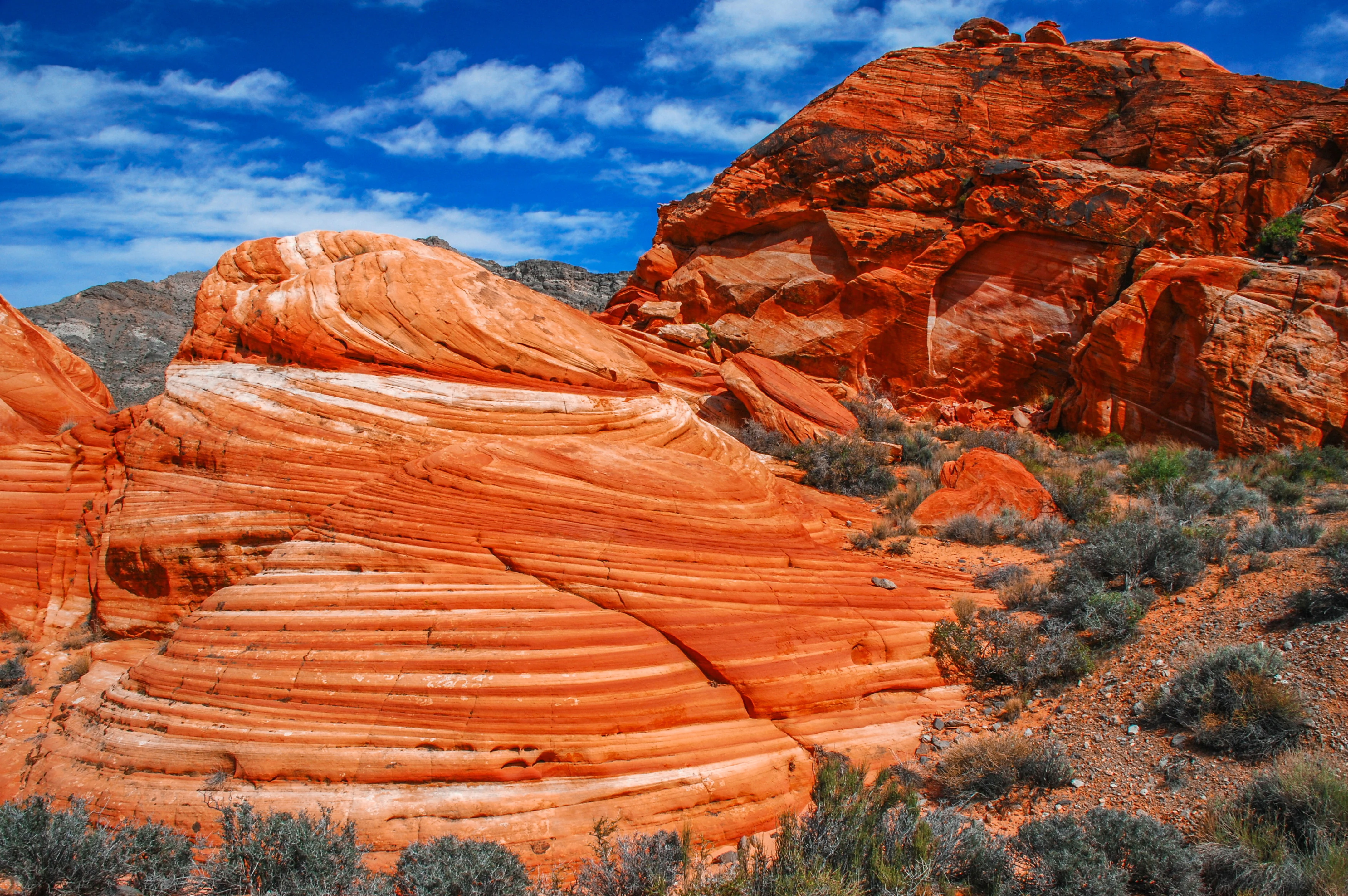
A desert landscape featuring vibrant orange, layered Aztec Sandstone with visible cross bedding patterns under a blue sky.
Prominent cross bedding patterns in the orange Aztec Sandstone of the Muddy Mountains Wilderness.

Muddy Mountains Wilderness history and protected-area timeline

The Muddy Mountains Wilderness was formally designated by the United States Congress in 2002, securing federal protection for nearly 48,154 acres of desert terrain in Clark County, Nevada. Its designation reflected a growing recognition of the ecological, scenic, and geological value of the Muddy Mountains range and its importance within the broader Lake Mead National Recreation Area.

Although the wilderness designation is recent, the area itself has a much longer human and natural story. Long before it became a protected landscape, the region was part of the traditional homeland of the Mojave people and other Indigenous groups who used the desert basins, springs, and rock shelters for sustenance and shelter. Rock artifacts, rock art, and ancient rock shelters still preserved in the wilderness attest to this enduring human relationship with the land.

On a geological timescale, the rocks of the Muddy Mountains tell an even deeper history. Roughly 300 million years ago, the area lay at the bottom of an ancient sea, and the sediments laid down in that environment were eventually transformed into the Aztec Sandstone that now dominates the wilderness scenery. This long geological inheritance, combined with more recent cultural history and modern conservation recognition, gives the wilderness a layered significance well beyond its formal designation date.

Muddy Mountains Wilderness landscape and geographic character

The landscape of Muddy Mountains Wilderness is dominated by the dramatic erosional forms of Aztec Sandstone, a brightly colored rock unit that produces vivid red, orange, and tan cliffs exposed across the range. Massive cross-bedded patterns are visible in many of the outcrops, recording the ancient dune and shallow marine environments that originally deposited the sand. Erosion has since sculpted this rock into ridges, canyons, washes, and isolated pinnacles that give the wilderness a rugged and visually varied terrain.

Elevations in the wilderness range from about 1,700 feet in the lower desert basins to roughly 5,400 feet along the higher ridges, producing steep local relief and a series of distinct topographic zones. The lower elevations open into broad desert flats and washes that gradually narrow and steepen as they approach the mountain front. From many vantage points within the wilderness, the waters of Lake Mead and the surrounding basin are clearly visible, anchoring the mountains within the larger Lake Mead landscape.

The contrast between the bare, sculpted sandstone and the deeply incised drainages cutting through it is one of the defining scenic qualities of the area. Dry washes, narrow slot-like cuts, and exposed cliff faces create a constantly shifting terrain that is both visually striking and challenging to traverse.

Muddy Mountains Wilderness ecosystems, habitats, and plant life

Ecologically, Muddy Mountains Wilderness sits firmly within the eastern Mojave Desert, where plant communities are shaped by arid conditions, strongly seasonal rainfall, and a wide range of elevations. The dominant vegetation across much of the area is typical Mojave Desert scrub, anchored by widespread creosote bush, with desert catalpa trees appearing in more favorable drainages and on sheltered slopes. These plant communities form the foundation of the food web that sustains the area's desert wildlife.

Among the more ecologically significant botanical features of the wilderness are populations of rare and localized plant species, including bear poppy and Las Vegas buckwheat, both of which are closely tied to the specialized soils and microhabitats of the eastern Mojave. The presence of these uncommon species adds botanical importance to the wilderness beyond what its scenery alone would suggest, and helps justify the area's protected status.

The transition zones between low desert flats, rocky slopes, and higher elevation ridges create a patchwork of habitats within the wilderness. This mosaic supports a variety of desert wildlife and provides critical connectivity across the broader Muddy Mountains landscape, linking the area to neighboring desert ecosystems and to the shoreline environments of Lake Mead.

Muddy Mountains Wilderness wildlife and species highlights

Muddy Mountains Wilderness supports a typical but ecologically important array of Mojave Desert fauna, with species adapted to arid conditions, rocky terrain, and wide temperature swings. Among the most prominent large mammals are desert bighorn sheep, which use the rugged sandstone terrain for movement, foraging, and escape from predators. The steep canyons and broken cliff faces of the Muddy Mountains provide ideal habitat for these animals.

The desert tortoise is another important resident of the wilderness, occupying lower elevation flats and washes where it can dig burrows in suitable soils. Because desert tortoise populations across the Mojave face significant conservation pressures, the protected status of the Muddy Mountains Wilderness is meaningful for the long-term survival of this species in the region. Gila monsters, one of the few venomous lizards native to the United States, also inhabit the area, adding to its reptile diversity.

Beyond these headline species, the broader wildlife community of the wilderness includes a range of smaller mammals, birds, reptiles, and invertebrates typical of the eastern Mojave. The wilderness's connectivity to surrounding desert basins and to the Lake Mead shoreline adds extra ecological value, particularly for migratory birds and animals that rely on multiple habitat types across the region.

Muddy Mountains Wilderness conservation status and protection priorities

Muddy Mountains Wilderness was designated by Congress in 2002 specifically to preserve a substantial block of eastern Mojave Desert landscape with notable geological, ecological, and cultural values. The designation provides a higher level of protection than ordinary public land, restricting road building, mechanized use, and other forms of development that could degrade the area's wilderness character.

The wilderness is jointly managed by the Bureau of Land Management and the National Park Service, and its location within the Lake Mead National Recreation Area links it to a larger network of protected desert and lake environments. This integration strengthens conservation outcomes by maintaining habitat continuity across administrative boundaries. The area's rare plant populations, including bear poppy and Las Vegas buckwheat, are an important part of the conservation rationale, as these species depend on the specialized desert conditions protected within the wilderness.

The wilderness also plays a role in conserving habitat for desert tortoise and desert bighorn sheep, both of which depend on large, connected expanses of undisturbed desert. By protecting nearly 48,154 acres of rugged terrain from major disturbance, the Muddy Mountains Wilderness contributes to the long-term ecological integrity of the eastern Mojave region, while also preserving the area's striking sandstone scenery and cultural sites for future generations.

Muddy Mountains Wilderness cultural meaning and human context

The Muddy Mountains have been part of Indigenous homelands for a very long time, with the territory historically associated with the Mojave people and other groups who made use of the desert's springs, washes, and rock shelters. Evidence of this long human presence remains visible in the wilderness in the form of rock artifacts, ancient rock shelters, and rock art, which together record generations of life adapted to the desert environment.

These cultural traces do not exist in isolation from the natural landscape; rather, they are woven into the same cliffs, canyons, and overhangs that define the wilderness today. Many of the rock shelters that hold cultural significance also reflect the geological character of the Aztec Sandstone that dominates the area, illustrating the close relationship between human history and the physical setting.

In a broader sense, the Muddy Mountains sit within a landscape of deep Indigenous heritage that extends across the lower Colorado River region. Recognizing this human history adds an important cultural layer to the wilderness, complementing its ecological and geological importance without overshadowing the natural values that are the primary focus of its protection.

Top sights and standout views in Muddy Mountains Wilderness

Muddy Mountains Wilderness offers some of the most visually striking Aztec Sandstone scenery in the eastern Mojave, with vivid cross-bedded cliffs, deep canyons, and bold color contrasts that reward exploration on foot. Its relatively compact size hides a surprising variety of terrain, from low desert washes with rare plants like bear poppy to rugged high ridges above 5,400 feet.

The wilderness also stands out for the strength of its sensory contrasts: open desert silence interrupted by the textures of sculpted stone, distant glimpses of Lake Mead far below, and the occasional sighting of desert bighorn sheep, desert tortoise, or Gila monster. Combined with its preserved cultural sites, these qualities make Muddy Mountains Wilderness a particularly rich example of the layered natural and human heritage of the Lake Mead region.

Best time to visit Muddy Mountains Wilderness

The character of a visit to Muddy Mountains Wilderness shifts significantly with the seasons, though the area is accessible year-round in mild conditions for those prepared for desert travel. Spring is typically the most rewarding time, when temperatures are moderate, wildflower and rare plant displays are most likely, and wildlife activity increases after winter rains.

Late fall and winter also offer cooler, more comfortable conditions for hiking and exploration, though shorter days and the occasional cold snap mean visitors should plan accordingly. Summer in the Mojave can be brutally hot, with extreme daytime temperatures that make strenuous activity dangerous; visitors during this period generally focus on early mornings, short routes, and well-planned hydration. Because the wilderness is managed for low-impact use, conditions on the ground are best assessed through current local information before any trip, regardless of season.
Monthly climate preview

Long-term representative temperature and precipitation rhythms across the coordinate point

Muddy Mountains Wilderness Climate Normals and Monthly Weather Data Profiles

Representative coordinate measurements record twelve-month temperature swings and precipitation rates for Muddy Mountains Wilderness from historical NASA records. Detailed monthly tables provide complete temperature averages and precipitation totals for deeper environmental comparison.
Annual mean17 °C
4 °C30 °C
Jan
Feb
Mar11°
Apr15°
May21°
Jun27°
Jul30°
Aug29°
Sep25°
Oct17°
Nov
Dec
Warmest month
July

30.1 °C

Coolest month
December

4.4 °C

Wettest month
February

1.1 mm/day

Driest month
June

0.1 mm/day

Park location guide

Geography guide, regional context, and park location map for Muddy Mountains Wilderness

Muddy Mountains Wilderness park geography, regions, and map view in United States of America

Understand where Muddy Mountains Wilderness sits in United States of America through a broader geographic reading of the surrounding landscape, nearby location context, and its mapped position within the national park landscape.

How Muddy Mountains Wilderness fits into United States of America

The United States of America is a federal presidential republic and one of the world's largest countries by area and population. It consists of 50 states across a vast territory spanning multiple time zones, with its capital in Washington, D.C. and largest city in New York City. The nation has a diverse economy, influential political system, and significant cultural and military presence globally.

Wider geography shaping Muddy Mountains Wilderness in United States of America

The United States occupies a vast territory in North America, bordered by Canada to the north and Mexico to the south. The 48 contiguous states stretch from the Atlantic to the Pacific Ocean, while Alaska occupies the northwestern region and Hawaii is an archipelago in the Pacific. The country encompasses diverse terrain including the Rocky Mountains, Appalachian Mountains, Great Plains, and extensive river systems.

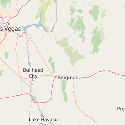
Map view of Muddy Mountains Wilderness

Use this park location map to pinpoint Muddy Mountains Wilderness in United States of America, understand its exact geographic position, and read its mapped placement within the surrounding landscape more clearly.

Pigeon | © OpenStreetMap contributors

Location context for Muddy Mountains Wilderness

Clark CountyNevada

Visualizing the sandstone cliffs, canyons, and Mojave Desert terrain

Muddy Mountains Wilderness Photos and Red Rock Desert Landscapes

Examine high-resolution imagery of Muddy Mountains Wilderness to understand the dramatic red rock formations and rugged desert topography. Visual records reveal the complex cross-bedded sandstone cliffs, deep drainage canyons, and protected Mojave Desert habitats that define the region.

A desert landscape featuring vibrant orange, layered Aztec Sandstone with visible cross bedding patterns under a blue sky.

Park atlas

Compare adjacent Mojave Desert landscapes and regional conservation areas.

Other Parks Near Muddy Mountains Wilderness and Surrounding Desert Protected Areas

Browse protected areas near Muddy Mountains Wilderness to examine shared desert topography and regional geological formations. Comparing adjacent wilderness units and national recreation zones reveals the broader ecological patterns shaping the eastern Mojave basin.
A watercolor painting showing a soft-toned landscape with a winding river in the foreground, a forested middle ground, and rolling mountains in the distance.
Protected landscapeUnited States of America
About 6.9 km away#1 closest

South

Lake Mead National Recreation Area: Desert Reservoir and Protected Landscape Atlas

United States protected geography and reservoir terrain

Spanning the lower Colorado River, Lake Mead National Recreation Area represents a unique convergence of desert ecosystems and large-scale water management. Its geography includes extensive reservoir shorelines, deep canyon corridors, and volcanic basin terrain that provide a foundational look at the arid environments of the American Southwest. The area remains a significant study of how engineered water features alter and interact with complex desert landscapes.

Area
6,053.31 km²
Established
1936
IUCN
V
Visitors
6.4M annual
Wildlife reserveNevada
About 35 km away#2 closest

South

Jimbilnan Wilderness: Geographic Overview and Protected Desert Landscape in Nevada

Mapping the canyons, washes, and plateaus of the Black Mountains

Jimbilnan Wilderness offers a dense mosaic of Mojave Desert habitats within a compact protected footprint. Located in Clark County, this Nevada wildlife reserve features a transition from deep, rocky canyons carved into the Black Mountains to wide desert washes and benches near Lake Mead. The area is notable for its botanical diversity, including rare milkvetch and buckwheat, serving as a critical link between upland desert systems and the lacustrine environment of the reservoir.

Area
76.4 km²
Established
2002
IUCN
Ib
Relief
Mountain
Wildlife reserveClark County
About 51 km away#3 closest

East

Jumbo Springs Wilderness: Geographic Profile and Protected Landscape Atlas

A rugged desert preserve in Clark County, Nevada

Jumbo Springs Wilderness preserves a dense concentration of desert geology within a compact footprint. Users can analyze the protected boundaries, which feature Precambrian metamorphic formations and granitic domes that rise above arid drainages. This area functions as a critical desert refuge near the Lake Mead reservoir, providing a distinct look at the transition between rocky mountain slopes and water-influenced desert microhabitats.

Area
18.74 km²
Established
2002
IUCN
Ib
Relief
Upland
National parkArizona
About 69 km away#4 closest

East

Grand Canyon National Park: Arizona National Park Protected Landscape & Geography

Explore mapped boundaries and regional atlas context.

Grand Canyon National Park stands as a premier national park, showcasing a unique protected landscape within Arizona's diverse geography. This detailed entry focuses on the park's specific geographic identity, its mapped boundaries, and its significance within the regional atlas. Discover the contours of this protected area and its place in the natural terrain of the American Southwest.

Area
4,926.08 km²
Established
1919
IUCN
II
Visitors
4.9M annual
A watercolor painting showing soft green hills, distant pink-hued mountains, and a pale blue lake in a serene, stylized landscape.
Protected landscapeNevada
About 72 km away#5 closest

Northwest

Humboldt, Toiyabe National Forest: Protected Landscape and Regional Mountain Geography

A vast network of Nevada mountain ranges and alpine wilderness

Humboldt, Toiyabe National Forest serves as a defining public land entity across Nevada and eastern California. As the largest national forest in the contiguous United States, it preserves a striking collection of isolated mountain ranges, including the Ruby Mountains and the rugged Jarbidge wilderness, within a broader basin-and-range landscape. Examine the boundaries and terrain that characterize this complex, high-desert ecosystem.

Area
25,454 km²
Established
1908
Relief
Mountain
Access
Easy access
Watercolor painting of green rolling hills and distant purple mountains with a small waterfall flowing into a body of water in the foreground.
Protected landscapeNevada
About 72 km away#6 closest

West

Spring Mountains National Recreation Area: Alpine Geography and Protected Mountain Landscapes

A rugged mountain anchor in the southern Nevada desert

Rising sharply from the desert floor, Spring Mountains National Recreation Area features dramatic elevation shifts across 316,000 acres of forested canyons and rocky ridges. This protected landscape preserves vital mountain habitat and diverse terrain, ranging from pinyon-juniper woodlands to high-alpine environments near Mount Charleston, serving as a distinct natural contrast to the Mojave surroundings.

Area
1,280 km²
Established
1993
IUCN
V
Relief
Mountain
Watercolor painting showing stylized green mountains, pine trees, and soft yellow and purple tones in the landscape.
Wildlife reserveNevada
About 78 km away#7 closest

West

Mount Charleston Wilderness: Protected Mountain Geography and Spring Mountains Atlas

High-altitude wilderness and ancient forest landscapes in southern Nevada

Spanning the crest of the Spring Mountains, Mount Charleston Wilderness stands as a protected natural landmark in Nevada. This area offers an atlas-focused view of subalpine ridges, ancient bristlecone pine forests, and steep fault-block terrain that contrast significantly with the arid Mojave Desert basins located below.

Area
232.46 km²
Established
1989
IUCN
Ib
Relief
Mountain
Wildlife reserveNevada
About 79 km away#8 closest

South

Ireteba Peaks Wilderness: Protected Desert Mountains and Lake Mohave Reservoir Shoreline

Mapping the Eldorado Mountains within southern Nevada desert protected areas.

Spanning the southern Eldorado Mountains and the northern shores of Lake Mohave, Ireteba Peaks Wilderness represents a critical Mojave Desert protected area. This landscape integrates rugged, rocky ridgelines with arid desert slopes and reservoir inlets. Its geographic character, shaped by both federal wilderness designation and proximity to the Avi Kwa Ame National Monument, preserves a vital slice of Nevada desert terrain and native ecological habitat.

Area
132.51 km²
Established
2002
IUCN
Ib
Relief
Mountain

Common questions about visiting, size, designation, and location context for Muddy Mountains Wilderness

Muddy Mountains Wilderness FAQs for park facts, access, geography, and protected area context

Find quick answers about Muddy Mountains Wilderness, including protected-area facts, park geography, trail and visitor context, and how the park fits into its surrounding country and regional landscape.
MoriAtlas Explorer

Continue Your Protected Areas Search Across the Global Atlas

Deepen your exploration by continuing the structured search for national parks and protected areas worldwide. Utilize the comprehensive filtering capabilities to compare different conservation landscapes and refine your understanding of global park geography. Discover more about the distribution and characteristics of protected natural areas.

Global natural geography