
Mori Atlas logo
Nature reserveMühlbachtal von Bergen-Enkheim

Mapping the distinct ecological boundaries and compact valley terrain of this regional refuge

Mühlbachtal von Bergen-Enkheim: A Protected Nature Reserve within the Hessen Landscape

Mühlbachtal von Bergen-Enkheim serves as a vital protected area within the Frankfurt district of Hessen, Germany. Covering a small yet botanically significant valley, this nature reserve features a mosaic of wet meadows, traditional orchards, and semi-dry grasslands. The site functions as a rare ecological refuge that preserves a unique population of great horsetail, representing a relic of former floodplain forests within an urbanized metropolitan setting.

small nature reservewet meadowtraditional orchardsemi-dry grasslandgreat horsetailfloodplain forest relic
A stylized graphic illustration depicting a valley with steep canyon walls, a central waterfall, a flowing stream, and evergreen trees under a soft-colored sky.

Mühlbachtal von Bergen-Enkheim

Nature reserve

Park overview

Structured park overview, official facts, and landscape profile for Mühlbachtal von Bergen-Enkheim

Mühlbachtal von Bergen-Enkheim park facts, protected area profile, and essential visitor context

Review the core facts for Mühlbachtal von Bergen-Enkheim, including designation, size, terrain, visitor scale, habitats, and operating context in one park-focused overview.

About Mühlbachtal von Bergen-Enkheim

Mühlbachtal von Bergen-Enkheim is a micro-scale nature reserve that punches well above its size in ecological significance. Tucked into the eastern outskirts of Frankfurt am Main in the district of Bergen-Enkheim, the reserve occupies a narrow, steep-sided valley carved by the historic Enkheimer Mühlbach into the southern slope of the Berger Rücken. With only 3.28 hectares, it is officially the smallest nature reserve within the city limits of Frankfurt.

Although its footprint is small, the valley preserves an unusually diverse botanical habitat. The presence of great horsetail (Equisetum telmateia) is its most distinctive feature; the species is otherwise entirely absent from the surrounding Rhine-Main region and is interpreted as a botanical relic of the ancient brook floodplain forests that once characterized this landscape. Surrounding habitats include wet meadows (Feuchtwiesen), traditional orchards (Streuobstwiesen), and semi-dry grassland (Halbtrockenrasen), each representing different stages of traditional land use and ecological succession on valley slopes.

The reserve was designated in 1986 and falls under IUCN Category IV as a Habitat/Species Management Area. Its location at the eastern edge of Frankfurt is particularly notable because the surrounding area is otherwise shaped by dense urban development typical of the Rhine-Main metropolitan region. In this context, Mühlbachtal functions as a small but valuable refuge for biodiversity, offering a contrast to the highly built-up surroundings.

The valley is also of cultural-historical interest. The Enkheimer Mühlbach, despite being only about 180 meters long, gave the valley its name and historically supported the Enkheimer Mühle, an 18th-century watermill. Today the mill pond has been filled in and the mill has not operated since 1890, but the stream and the mill are still part of the local cultural memory, listed as stations on the Quellenwanderweg im Frankfurter Grüngürtel, a themed trail that follows the city's historical springs.

Quick facts and research context for Mühlbachtal von Bergen-Enkheim

Mühlbachtal von Bergen-Enkheim is an IUCN Category IV Habitat/Species Management Area located in the eastern Frankfurt district of Bergen-Enkheim, in Hesse, Germany. Established in 1986, it covers approximately 3.28 hectares on the southern slope of the Berger Rücken ridge, making it the smallest nature reserve in Frankfurt am Main.

The reserve is officially recorded under the identifier 1412006 and in the World Database on Protected Areas as WDPA-ID 164717. Its defining ecological feature is the presence of great horsetail (Equisetum telmateia), a species otherwise absent from the Rhine-Main region, alongside wet meadows, traditional orchards (Streuobstwiesen), and semi-dry grassland.

Protection and recognition

Examine official designation records and management frameworks for this protected area.

Mühlbachtal von Bergen-Enkheim Protection Status and International Recognition

Mühlbachtal von Bergen-Enkheim brings together documented protection status details and official database registries for conservation analysis. Researchers examine verified protected area data to understand statutory frameworks and international recognition records.

Protection details

WDPA ID
164717
Park context

Deeper park guide and search-rich context for Mühlbachtal von Bergen-Enkheim

Mühlbachtal von Bergen-Enkheim history, landscape, wildlife, and travel context

Explore Mühlbachtal von Bergen-Enkheim through its history, landscape character, ecosystems, wildlife, conservation priorities, cultural context, and seasonal travel timing in a structured park guide built for atlas discovery and search intent.

Why Mühlbachtal von Bergen-Enkheim stands out

Mühlbachtal is best known for hosting the only population of great horsetail (Equisetum telmateia) in the entire Rhine-Main region, a species considered a living relic of the brook floodplain forests that once occupied the area. The reserve also stands out for combining several distinct habitat types, including wet meadows, traditional orchards, and semi-dry grassland, within an exceptionally compact protected area of just 3.28 hectares. The valley's identity is closely tied to the Enkheimer Mühlbach, historically one of Frankfurt's shortest streams, which once powered the Enkheimer Mühle watermill. Both the stream and the mill are recognized stations on the Quellenwanderweg, a hiking trail tracing historical springs along Frankfurt's green belt.
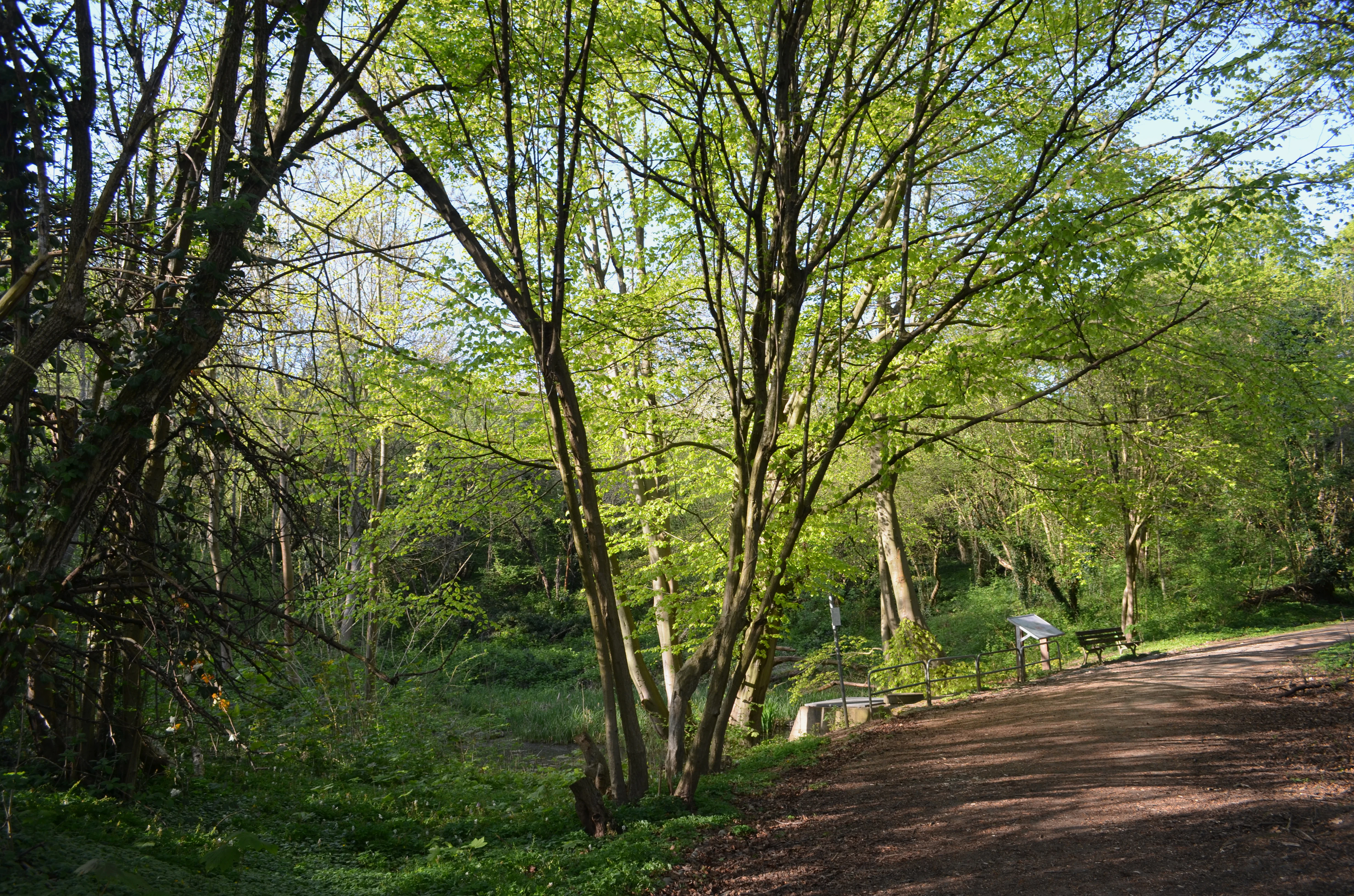
A dirt path winds through a bright green, leafy deciduous forest in spring, with a small information sign visible near the trees.
A view of the woodland path in the Mühlbachtal nature reserve during spring.

Mühlbachtal von Bergen-Enkheim history and protected-area timeline

The Mühlbachtal has been formally protected as a nature reserve (Naturschutzgebiet) since 1986, when it was designated by the city of Frankfurt am Main. The designation recognized both the valley's botanical importance, especially its unique population of great horsetail, and its compact mosaic of meadow and orchard habitats at the edge of a heavily urbanized metropolitan area.

The valley's cultural history, however, reaches back considerably further. The Enkheimer Mühlbach, one of Frankfurt's shortest streams at roughly 180 meters in length, was fed by several local springs named Schelmenborn, Röhrborn, Hessenborn, and Jakobsbrunnen, with the Pfingstborn added to the system from 1850 onward. A mill pond channeled this water to drive the Enkheimer Mühle, an 18th-century watermill. The mill continued operating until 1890, after which the mill pond was filled in and the historic water-driven function of the valley effectively ended.

In more recent years, there have been plans to renaturalize the Enkheimer Mühlbach and to redirect its flow back into the nearby Seckbacher Ried, a former Main river oxbow. The goal of this effort is to improve the water balance of the larger wetland area. Today the stream's visible source lies beneath the Heinrich-Bingemer-Weg in Bergen-Enkheim at about 138 meters above sea level, and the water disappears into the local sewer system shortly after at approximately 115 meters above sea level, following a steep descent.

Mühlbachtal von Bergen-Enkheim landscape and geographic character

The Mühlbachtal occupies a narrow valley cut between five and eight meters deep into the southern slope of the Berger Rücken ridge. This southern slope is described as particularly steep within the ridge's profile, giving the reserve a sheltered, valley-like character despite its very small size. The valley's modest dimensions, combined with the strongly sloping terrain, create a sharp local contrast with the flatter urban surroundings of eastern Frankfurt.

The valley floor itself is shaped by the shallow channel of the Enkheimer Mühlbach and by the meadow habitats that have developed along it. On the slopes above and alongside the stream, traditional orchards and semi-dry grassland reflect centuries of cultural land use, with the vegetation pattern clearly influenced by the transition from moist valley-bottom conditions to drier, more sun-exposed slope environments. The named source of the Mühlbach lies beneath the Heinrich-Bingemer-Weg, and the channel drops steeply from approximately 138 meters to about 115 meters above sea level before disappearing into urban drainage.
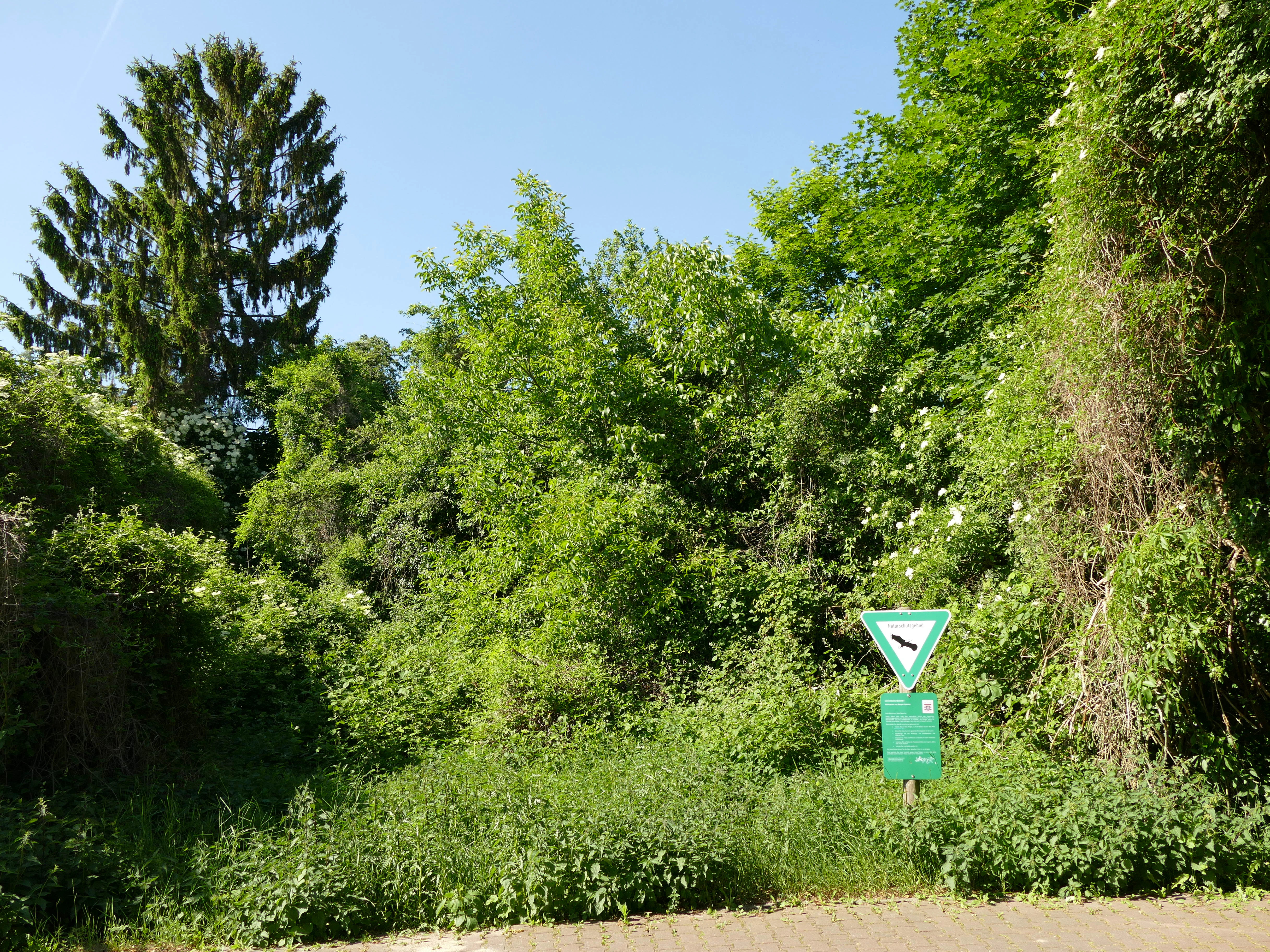
A triangular green and white nature reserve sign stands in front of a dense, lush green forest border.
A nature reserve sign marks the northern section of the Mühlbachtal valley.

Mühlbachtal von Bergen-Enkheim ecosystems, habitats, and plant life

Ecologically, Mühlbachtal is a textbook example of how much biological value can fit into a very small protected area. The defining habitat element is the population of great horsetail (Equisetum telmateia), which is interpreted as a relic of the historic brook floodplain forest, or Bachauenwald, that once occupied the valley. The species' presence here is the only known occurrence of this plant in the entire Rhine-Main region, lending the reserve disproportionate botanical significance relative to its size.

The valley's broader vegetation reflects a layered mosaic typical of small traditional valley landscapes. Along the drainage line and on the lower slopes, wet meadows (Feuchtwiesen) dominate, supported by the valley's moisture-retaining conditions and the influence of the small stream. Higher and drier zones transition into semi-dry grassland (Halbtrockenrasen), while the flatter, more accessible areas preserve traditional orchards (Streuobstwiesen), reflecting long-standing agricultural use. Together, these habitats create a compact but ecologically varied patchwork that supports a wider range of species than the reserve's modest area might suggest.
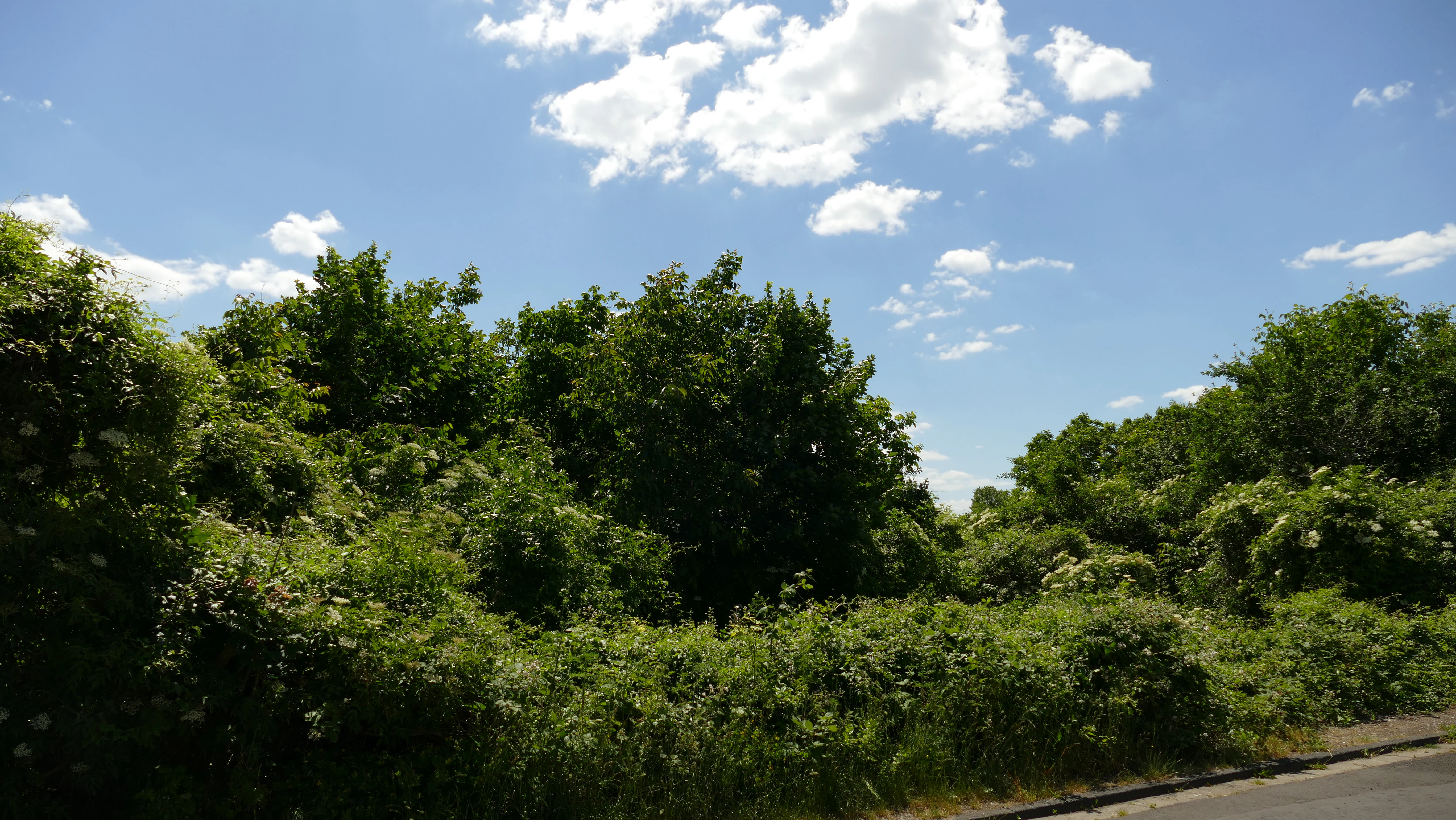
A view of dense green trees and shrubs under a bright blue sky with white clouds in the Mühlbachtal nature reserve.
View of the lush green vegetation in the Mühlbachtal nature reserve.

Mühlbachtal von Bergen-Enkheim wildlife and species highlights

The source material for Mühlbachtal places primary emphasis on the area's botanical rather than zoological significance. The standout wildlife-related feature is the population of great horsetail (Equisetum telmateia), which functions both as a botanical species and as the key indicator of the valley's relict floodplain forest character. Beyond this, the source does not provide detailed information on specific animal species inhabiting the reserve. As a small mosaic of wet meadows, traditional orchards, and dry grassland, however, the valley would be expected to support a corresponding mix of insects, small mammals, and typical orchard and meadow birdlife consistent with similar habitats in the Rhine-Main area.

Mühlbachtal von Bergen-Enkheim conservation status and protection priorities

The conservation significance of Mühlbachtal lies in the protection of a small but ecologically distinctive site at the eastern edge of one of Germany's largest metropolitan areas. With only 3.28 hectares, the reserve is the smallest nature reserve in Frankfurt am Main, yet it preserves habitats and species, most notably great horsetail, that have effectively disappeared from the surrounding region. Its designation in 1986 under the framework of Germany's nature reserve system recognized this small valley as a meaningful refuge for biodiversity.

Officially, the area is classified as an IUCN Category IV Habitat/Species Management Area, reflecting its role in actively maintaining specific habitats and species rather than functioning as a strictly untouched wilderness. The reserve is registered under German identifier 1412006 and has World Database on Protected Areas entry 164717, integrating it into the international protected-area network alongside much larger sites.

There is also a continuing conservation interest beyond the reserve itself. Plans to renaturalize the Enkheimer Mühlbach and redirect its flow back toward the Seckbacher Ried aim to improve the water balance of the larger adjacent wetland system, suggesting that the ecological value of Mühlbachtal is increasingly understood in connection with the wider surrounding landscape rather than as an isolated site.

Mühlbachtal von Bergen-Enkheim cultural meaning and human context

Although Mühlbachtal is primarily a natural site, its identity is closely interwoven with the historical land use of Bergen-Enkheim. The valley's name comes from the Enkheimer Mühlbach and the now-disused Enkheimer Mühle, an 18th-century watermill whose mill pond once occupied the valley bottom. The mill ceased operation in 1890, and the pond was later filled in, but this industrial-rural heritage remains an important part of the valley's character.

The valley's springs, including the Schelmenborn, Röhrborn, Hessenborn, Jakobsbrunnen, and from 1850 onward the Pfingstborn, were originally tapped and piped to feed the mill channel. Today the stream and the mill site are both recognized as numbered stations on the Quellenwanderweg im Frankfurter Grüngürtel, a themed hiking trail that follows the historical springs of Frankfurt's green belt. This integration into the local trail network reflects the valley's dual role as both a natural refuge and a tangible link to the traditional rural landscape of eastern Frankfurt.

Top sights and standout views in Mühlbachtal von Bergen-Enkheim

At just 3.28 hectares, Mühlbachtal is the smallest nature reserve in Frankfurt am Main. Its globally regional significance rests on its population of great horsetail (Equisetum telmateia), the only known occurrence of the species in the entire Rhine-Main region and a living relic of the former brook floodplain forest. The compact mosaic of wet meadow, traditional orchard, and semi-dry grassland creates remarkable habitat diversity within an exceptionally small footprint.

The valley is also historically layered: the 180-meter-long Enkheimer Mühlbach and the 18th-century Enkheimer Mühle watermill lend the site a strong cultural dimension. Both the stream and the mill are featured as stations on Frankfurt's Quellenwanderweg, a trail that connects the city's traditional springs. Designated as a nature reserve in 1986 and classified as an IUCN Category IV protected area, Mühlbachtal shows how even a tiny urban-edge valley can carry disproportionate ecological, botanical, and cultural weight.

Best time to visit Mühlbachtal von Bergen-Enkheim

The source material does not provide detailed seasonal visitation guidance for Mühlbachtal. As a very small protected area with a mosaic of wet meadows, orchards, and dry grassland on a south-facing slope, the valley is likely to be most visibly active in late spring and early summer, when the great horsetail and the surrounding meadow and grassland vegetation are at their most expressive. In autumn, the traditional orchards would display harvest character typical of Streuobstwiesen in Hesse. Weather conditions and trail-surface conditions, however, should always be considered on a steep south-facing slope.

Monthly climate preview

Long-term temperature ranges and monthly precipitation averages across the protected terrain

Mühlbachtal von Bergen-Enkheim Climate Normals and Annual Weather Patterns

Mühlbachtal von Bergen-Enkheim experiences long-term monthly temperature variations alongside steady precipitation rates throughout the recorded climatology period. Examining the complete twelve-month record reveals detailed annual weather distributions and representative meteorological baselines for this conservation area.
Annual mean10 °C
0 °C21 °C
Jan
Feb
Mar
Apr10°
May14°
Jun18°
Jul21°
Aug20°
Sep15°
Oct10°
Nov
Dec
Warmest month
July

20.6 °C

Coolest month
January

0.2 °C

Wettest month
July

2.2 mm/day

Driest month
April

1.4 mm/day

Park location guide

Geography guide, regional context, and park location map for Mühlbachtal von Bergen-Enkheim

Mühlbachtal von Bergen-Enkheim park geography, regions, and map view in Germany

Understand where Mühlbachtal von Bergen-Enkheim sits in Germany through a broader geographic reading of the surrounding landscape, nearby location context, and its mapped position within the national park landscape.

How Mühlbachtal von Bergen-Enkheim fits into Germany

Germany is a federal republic in Western and Central Europe with a population of over 83 million across sixteen constituent states. It is Europe's largest economy by nominal GDP and a major global exporter and importer. The capital is Berlin, and the country borders Denmark, Poland, Czech Republic, Austria, Switzerland, France, Luxembourg, Belgium, and the Netherlands.

Wider geography shaping Mühlbachtal von Bergen-Enkheim in Germany

Germany is located in Western and Central Europe, spanning 357,022 km². It borders Denmark to the north, Poland and the Czech Republic to the east, Austria and Switzerland to the south, and France, Luxembourg, Belgium, and the Netherlands to the west. The country has coastlines on the Baltic Sea and North Sea to the north, with the Alps located in the southern region.

Map view of Mühlbachtal von Bergen-Enkheim

Use this park location map to pinpoint Mühlbachtal von Bergen-Enkheim in Germany, understand its exact geographic position, and read its mapped placement within the surrounding landscape more clearly.

Pigeon | © OpenStreetMap contributors

Location context for Mühlbachtal von Bergen-Enkheim

Hessen

Visual exploration of steep slope terrain, wet meadows, and rare valley habitats

Mühlbachtal von Bergen-Enkheim Photos and Landscape Scenery

Photographic records capture the steep southern slopes, valley floor wetlands, and distinct vegetation mosaics defining this protected Frankfurt landscape. Visual reference material reveals the compact terrain and botanical character shaping this unique urban nature reserve.

A dirt path winds through a bright green, leafy deciduous forest in spring, with a small information sign visible near the trees.

A triangular green nature reserve sign on a wooden post surrounded by dense green vegetation on a clear day.

A triangular green and white nature reserve sign stands in front of a dense, lush green forest border.

A view of dense green trees and shrubs under a bright blue sky with white clouds in the Mühlbachtal nature reserve.

Park atlas

Compare surrounding protected landscapes and neighboring nature reserves across the region.

Other Parks Near Mühlbachtal von Bergen-Enkheim: Protected Areas and Regional Geography

Browsing other parks near Mühlbachtal von Bergen-Enkheim reveals related protected areas and diverse natural habitats within the surrounding region. Expanding the geographic comparison helps trace neighboring conservation landscapes and connected terrain features beyond a single reserve.
A soft watercolor painting of a pond with reeds in the foreground and a tree-lined bank in the background, set against a pale, washed-out sky.
Nature reserveHesse
About 2.2 km away#1 closest

East

Enkheimer Ried Nature Reserve: Geographic Overview and Protected Area Boundaries

Wetland landscape analysis within the Hesse region of Germany

Enkheimer Ried functions as a distinct nature reserve and wetland anchor near Frankfurt. This entry examines its spatial composition, including the central Riedteich pond and the Tränkebach floodplain, providing a clear geographic context for this ecologically rich conservation site in the heart of the Rhine-Main urban environment.

Area
0.282 km²
Established
1973
IUCN
IV
Relief
Lowland
A soft, horizontal watercolor painting depicting green rolling hills and wetland vegetation.
Nature reserveHessen
About 7.9 km away#2 closest

West

Riedwiesen Nature Reserve: Mapped Protected Wet Meadow Landscapes in Hessen, Germany

A critical fragment of floodplain ecology within the Frankfurt Grüngürtel

Riedwiesen serves as a protected nature reserve, preserving 20 hectares of wet meadow habitat along the Nidda river. This site highlights the intersection of urban infrastructure and resilient floodplain geography, providing a refuge for characteristic amphibians and wetland vegetation within the Hessen landscape.

Area
0.205 km²
Established
1983
IUCN
IV
Nature reserveLandkreis Offenbach
About 9.6 km away#3 closest

Southeast

Mayengewann von Lämmerspiel: Nature Reserve and Protected Landscape in Landkreis Offenbach

Oak woodlands and rare orchid meadows within the Rhine-Main landscape

Examine the geography of Mayengewann von Lämmerspiel, a significant nature reserve characterized by its mosaic of old oak forest and moist grassland. This site acts as an ecological refuge in Landkreis Offenbach, safeguarding rare species such as the fen violet, adder's-tongue fern, and multiple orchid varieties within a carefully managed protected boundary.

Area
0.067 km²
Established
1985
IUCN
IV
Relief
Lowland
A soft watercolor painting of a serene landscape featuring a central body of water surrounded by green banks, shrubs, and gentle rolling hills in the background.
Nature reserveHessen
About 9.9 km away#4 closest

Southeast

Oberwaldsee von Dietesheim Nature Reserve: Atlas and Geographic Landscape Overview

Protected basalt terrain in the Hessen region

Discover the geographic character of Oberwaldsee von Dietesheim, a protected nature reserve in Hessen defined by flooded basalt quarries and open sandy dry-grassland. This site serves as a vital ecological stepping stone within the Untermain lowlands, offering a study in microtopography and habitat diversity. Access detailed mapping and protected-area context for this essential German nature reserve within the Rhine-Main metropolitan corridor.

Area
0.335 km²
Established
1989
IUCN
IV
Watercolor painting of a green wetland landscape with trees, grasses, and distant rolling hills on a white background.
Nature reserveHessen
About 10 km away#5 closest

Southeast

Erlensteg von Bieber Nature Reserve: Geographic Map and Protected Habitat Overview

Compact wetland and forest mosaic in the Hessen region

Erlensteg von Bieber preserves a rare concentration of habitat types within a small footprint. From its moist floodplain meadows and sedge wetlands to its drier forest glades and fallow fields, this reserve showcases vital conservation management in the Rhine-Main area of Germany.

Area
0.752 km²
Established
1996
IUCN
IV
Watercolor illustration of a soft rolling landscape with grassy fields, scattered trees, and rolling hills in shades of green and yellow.
Nature reserveHessen
About 10 km away#6 closest

Southeast

Amerikafeld und Schindkaute bei Steinheim: Nature Reserve and Protected Grassland Map

Rare sand dry grassland habitat within the Hessen metropolitan region.

Amerikafeld und Schindkaute bei Steinheim is a protected nature reserve in Hanau that shelters scarce sand dry grasslands. The terrain, defined by ice-age sandy deposits, remains an important ecological island, maintaining an open steppe-like character through historic grazing practices in a landscape otherwise dominated by urban growth.

Area
16 km²
Established
1995
Nature reserveHessen
About 10 km away#7 closest

South

Bruch von Gravenbruch Nature Reserve: Geographic Profile and Protected Wetland Mapping

Hessen lowland moor and wetland habitat analysis

Examine the detailed terrain of Bruch von Gravenbruch, a notable nature reserve in Hessen characterized by its high groundwater table and intricate moisture-dependent ecosystems. The area serves as a key reference for studying lowland moor development, bog woodland structure, and the spatial distribution of protected wetland meadows across the regional landscape.

Area
0.932 km²
Established
1984
IUCN
IV
Nature reserveHessen
About 11 km away#8 closest

South

Luderbachaue von Dreieich: A Protected Floodplain Forest and Habitat in Hessen, Germany

Mapping the ecological geography of a significant lowland nature reserve

Spanning over 290 hectares, Luderbachaue von Dreieich serves as a major protected floodplain forest. The site preserves a diverse mosaic of oak, beech, and alder-ash woodlands that sustain rare fungal communities and old-growth timber, maintaining a vital green corridor in the urbanized Rhine-Main region.

Area
2.938 km²
Established
1996
IUCN
IV
Relief
Lowland

Common questions about visiting, size, designation, and location context for Mühlbachtal von Bergen-Enkheim

Mühlbachtal von Bergen-Enkheim FAQs for park facts, access, geography, and protected area context

Find quick answers about Mühlbachtal von Bergen-Enkheim, including protected-area facts, park geography, trail and visitor context, and how the park fits into its surrounding country and regional landscape.
MoriAtlas Explorer

Continue Your Protected Areas Search Across the Global Atlas

Deepen your exploration by continuing the structured search for national parks and protected areas worldwide. Utilize the comprehensive filtering capabilities to compare different conservation landscapes and refine your understanding of global park geography. Discover more about the distribution and characteristics of protected natural areas.

Global natural geography