Why Muni-Pomadze Ramsar Site stands out
Muni-Pomadze is especially known for the convergence of a coastal lagoon, mangrove vegetation, and forested reserves within a single Ramsar-designated site. The wetland is celebrated for its seasonal flooding dynamics, where the Muni Lagoon fills during the rainy season and occasionally spills across the surrounding floodplain. The site is also recognized for its birdlife and for the layered vegetation zones that line its shoreline, including halophytic plants such as Sesuvium portulacastrum along the dunes, mangrove stands in the northern wetland, and freshwater hydrophytes further inland. The blend of lagoon, dunes, mangroves, and upland vegetation gives the site a distinctive ecological character that few other Ghanaian wetlands share at this scale.
Muni-Pomadze Ramsar Site history and protected-area timeline
The Muni-Pomadze Ramsar Site was formally designated as a wetland of international importance under the Ramsar Convention in 1992. Its recognition drew attention to a landscape that had long supported local livelihoods, including fishing along the lagoon and traditional land use by the Efutu people in the surrounding inland areas.
Later in its protected history, the site gained additional international recognition when BirdLife International designated it as an Important Bird Area, citing the significant bird populations supported by its mosaic of lagoon, mangrove, and forest habitats. The Yenku A and Yenku B Forest Reserves, which cover a portion of the wider site, added an existing layer of forest protection to the Ramsar designation.
In more recent years, the conservation story of Muni-Pomadze has been shaped by community-led restoration. Between 2013 and 2014, A Rocha Ghana worked with over 3,000 people from three adjacent communities to promote the conservation and sustainable use of mangrove resources. This was supported by Canadian Fund for Local Initiative funding, which financed mangrove seedlings, particularly Rhizophora stylosa, planted in degraded parts of the wetland by members of the Nsuakyir and Warabeba fishing communities. These efforts have helped to embed the site firmly in the local conservation identity of Ghana's Central Region.
Muni-Pomadze Ramsar Site landscape and geographic character
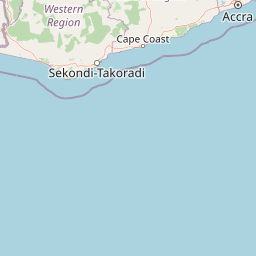
The landscape of Muni-Pomadze is defined by a compressed sequence of coastal and inland landforms. At its southern edge lies the Muni Lagoon and an adjacent beach, with sand dunes rising inland from the shoreline. These dunes have been planted with coconut palms, producing a distinctive coastal profile that transitions from open sand into cultivated and natural vegetation within a short distance.
North of the lagoon, the terrain rises into a gently undulating plain. The Yenku Hills in the north and north-east reach approximately 290 metres, while the Egyasimanku Hills in the south-west reach about 205 metres. The slopes that face the lagoon are relatively steep, shaping how seasonal rainfall moves across the catchment and into the water bodies below.
Three seasonal streams, the Pratu, the Boaku, and the Muni, run through this landscape and drain into the lagoon, creating a network of freshwater inputs that influence both the ecology and the seasonal rhythm of the site. The combination of dunes, floodplain, lagoon, forested hills, and coastal beach gives Muni-Pomadze a remarkably diverse physical setting for a wetland of its size.
Muni-Pomadze Ramsar Site ecosystems, habitats, and plant life
The ecological identity of Muni-Pomadze is built around the meeting point of saline, brackish, and freshwater environments. The lagoon and its fringing vegetation form the southern ecological core of the site, while mangroves and freshwater plant communities extend the wetland inward. Further inland, vegetation shifts again into grassland, thickets, eucalypt plantations, and areas of forest at varying stages of maturity, creating a layered ecological mosaic.
Shoreline vegetation follows a clear zonation pattern. Species such as Sesuvium portulacastrum, Pabulum vaginatum, and Bosporus virginicus occupy successive bands along the dunes. Behind these dunes, mangrove communities become prominent in the northern wetland, with species such as Typha australis and Ludwigia erecta occupying the freshwater zones further inland. This compositional gradation from halophytes to mangroves to freshwater hydrophytes gives the site a textbook example of coastal wetland vegetation transitions.
Upland vegetation, including eucalypt plantations and regenerating forest, complements the wetland systems and helps to buffer the catchment. The combined effect is a habitat mosaic where aquatic, saline, and terrestrial ecosystems interact closely within a relatively compact geographical footprint.
Muni-Pomadze Ramsar Site wildlife and species highlights
Although small in overall extent, Muni-Pomadze supports rich birdlife across its lagoon, mangrove, mangrove-edge, and forest habitats. The site's designation as an Important Bird Area by BirdLife International reflects the significance of the populations it sustains, drawing on the combination of open water, shoreline vegetation, mangroves, and surrounding woodland.
The diversity of habitat types allows the site to support both water-associated birds tied to the lagoon and mangroves, and forest-associated species using the upland vegetation. Seasonal fluctuations in water levels, including the rare full flooding events, are likely to influence food availability and habitat use for resident and visiting species throughout the year.
Muni-Pomadze Ramsar Site conservation status and protection priorities
Muni-Pomadze's conservation significance begins with its 1992 Ramsar designation, which placed it within the global network of wetlands recognized for their ecological and hydrological value. The site's combination of lagoon, mangroves, freshwater streams, and forest reserves gives it a layered protection profile that goes beyond a single habitat type.
BirdLife International's designation of Muni-Pomadze as an Important Bird Area added another international layer of recognition, particularly because the site's mosaic of habitats supports significant populations of multiple bird species. The presence of the Yenku A and Yenku B Forest Reserves extends the protection into upland forest vegetation, providing additional habitat continuity.
Community-based restoration has become an increasingly important dimension of conservation at Muni-Pomadze. Efforts led by fishing communities in Nsuakyir and Warabeba, supported by the Canadian Fund for Local Initiative and coordinated by A Rocha Ghana, have focused on replanting degraded mangrove areas, particularly with Rhizophora stylosa. These efforts reflect a model in which local livelihood communities are directly engaged in restoring the wetland resources on which they also depend.
Muni-Pomadze Ramsar Site cultural meaning and human context
The Efutu people have a longstanding cultural and traditional relationship with the inland portions of the Muni-Pomadze landscape, where their traditional hunting areas continue to overlap with the protected site. This connection provides an important continuity between historical land use and the modern protected area framework.
Fishing communities such as Nsuakyir and Warabeba, located adjacent to the site, are deeply tied to the lagoon and its resources. Their direct involvement in mangrove restoration has reinforced the cultural importance of the wetland as both a livelihood base and a community-protected natural area.
Top sights and standout views in Muni-Pomadze Ramsar Site
The site's most distinctive features include the seasonal flooding dynamics of the Muni Lagoon, the clearly zoned shoreline vegetation from halophytes through mangroves to freshwater species, and the unusual proximity of dunes, lagoon, forest reserves, and hills within a single Ramsar boundary. The convergence of Ramsar, Important Bird Area, and forest reserve protections makes Muni-Pomadze an unusually layered protected landscape along Ghana's coast.
Community-led mangrove restoration also distinguishes the site, demonstrating how local fishing communities have become active stewards of an internationally recognized wetland.
Best time to visit Muni-Pomadze Ramsar Site
The wetland's character shifts strongly with the seasons, since the Muni Lagoon and its catchment are shaped by seasonal rainfall. Visits during or shortly after the rainy season are likely to coincide with higher water levels in the lagoon and active stream flow through the Pratu, Boaku, and Muni catchments, while drier periods bring visibly lower water levels and more exposed shoreline vegetation along the dunes and lagoon margins.
Migratory and resident bird activity across the lagoon, mangroves, and upland habitats can vary with these seasonal conditions, making the wet and post-wet seasons particularly relevant for visitors interested in waterbird presence and flooded floodplain scenery. Travellers should expect the landscape to feel distinctly different between wet and dry phases rather than uniform throughout the year.