

Mori Atlas logo
Natural monumentNa loučkách II

Understanding the upland mosaic of heathlands, peatlands, and diverse montane habitats

Na loučkách II Natural Monument: Geography and Protected Landscape Context in the Ore Mountains

Na loučkách II is a significant protected natural monument located in the upper Ore Mountains of the Czech Republic. This upland site, situated within the Ústecký kraj region, features a complex mosaic of secondary montane habitats including extensive heathland, species-rich meadow clearings, and active peatland basins. Its geographic boundaries protect a critical mountain refugium for rare fauna and preserve the hydrological integrity of the surrounding Krušné hory landscape.

natural monumentheathlandpeatlandKrušné horyOre Mountainsblack grouse
A flat-style digital illustration depicting a mountain valley with a waterfall flowing from cliffs into a river, surrounded by pine and birch trees in a lush meadow.

Na loučkách II

Natural monument

Park overview

Structured park overview, official facts, and landscape profile for Na loučkách II

Na loučkách II park facts, protected area profile, and essential visitor context

Review the core facts for Na loučkách II, including designation, size, terrain, visitor scale, habitats, and operating context in one park-focused overview.

About Na loučkách II

Na loučkách II is a natural monument (přírodní památka) in the upper reaches of the Ore Mountains, the long mountain range that forms much of the northwestern borderlands of the Czech Republic. The protected area lies southwest of the town of Výsluní, in the Chomutov district of the Ústecký Region, and covers an extensive block of upland terrain spanning several cadastral territories. Geographically, it sits at moderate mountain elevation, between approximately 738 and 850 meters above sea level, within a landscape shaped historically by peat extraction, forestry, and energy supply to medieval and early industrial industries.

The site is administratively divided into two main sections. The western part is partially separated from the rest by the corridor of the Chomutov, Vejprty railway line along the slopes of the hill called Výšina. The larger eastern section surrounds two exclaves that have been excluded from protection: a meadow area northwest of Výsluní near Nový rybník and Rybníček u Nových Domků, and a small valley stretch along the Prunéřovský potok stream north of town. To the north, Na loučkách II borders a smaller, related nature reserve simply called Na loučkách, with which it forms an ecologically coherent complex.

Ecologically, the monument exists within a wider conservation network. It overlaps with the European Site of Community Importance (EVL) named Na loučkách and lies inside the Bird Protection Area Novodomské rašeliniště, Kovářská, which designates the area for its importance to breeding and migrating birds. This dual designation places the site within both habitat-based and species-based European conservation frameworks, reflecting its value for peatland, heathland, and birdlife in the Czech portion of the Krušné hory.

The primary conservation aim is to preserve the mosaic of secondary montane and submontane habitats: heaths, meadows, and peatlands together with their characteristic fauna and flora. Alongside habitat protection, the management seeks to restore the natural hydrological regime of these wetlands and to allow peat-forming processes to continue without human interference where possible.

Quick facts and research context for Na loučkách II

Na loučkách II is a Czech natural monument (přírodní památka, IUCN category IV) located in the upper Ore Mountains near Výsluní in the Chomutov district. It lies at an elevation of roughly 738 to 850 meters and spans several cadastral territories, including Přísečnice, Rusová, Sobětice u Výsluní, Třebíška, Volyně u Výsluní, and Výsluní. The protected area was declared administratively by the Regional Authority of the Ústecký Region and came into force in late December 2013. Its designated conservation targets are secondary mountain and submontane heathland, meadows, and peatland habitats, along with the species they support.

Protection and recognition

Explore the terrestrial protected area designation and official management records

Na loučkách II Protection Status and Documented Conservation Scope

Na loučkách II maintains a documented terrestrial protection status with structured records covering conservation parameters. Official data details the established management scope and formal designation framework for the protected area.

Protection details

Protection scope
Terrestrial
Transboundary protection
No
Park context

Deeper park guide and search-rich context for Na loučkách II

Na loučkách II history, landscape, wildlife, and travel context

Explore Na loučkách II through its history, landscape character, ecosystems, wildlife, conservation priorities, cultural context, and seasonal travel timing in a structured park guide built for atlas discovery and search intent.

Why Na loučkách II stands out

Na loučkách II is best known for its extensive upland heath and peatland mosaic in the Krušné hory, which provides habitat for the black grouse (Tetřívek obecný), one of the most threatened grouse species in Central Europe. The site is also recognized for its population of boreal owls and Eurasian pygmy owls, as well as its role within the broader Novodomské rašeliniště, Kovářská Bird Protection Area.
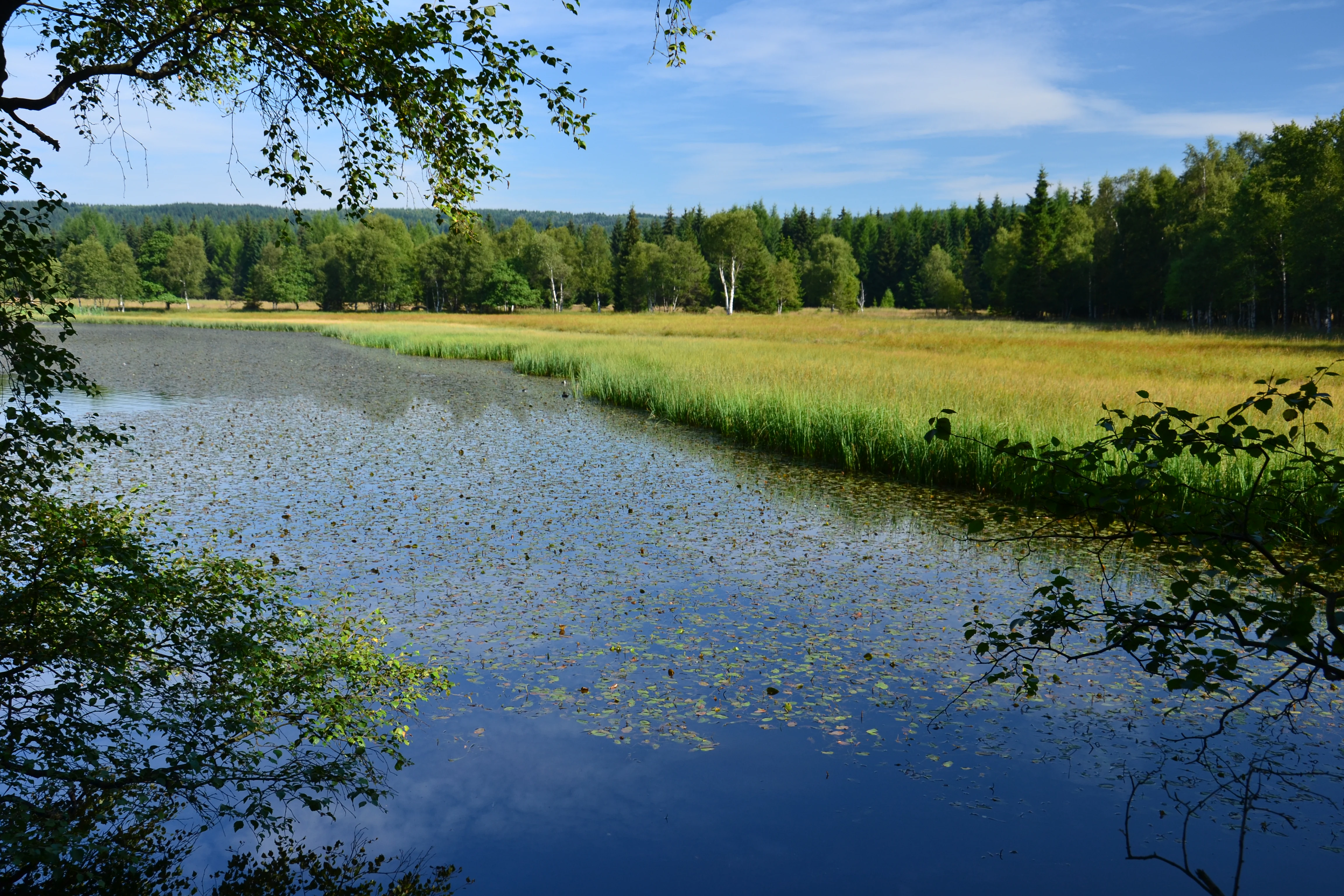
A peaceful pond framed by foreground tree branches with a grassy meadow and dense forest in the background.
A view of the pond at the Na loučkách II natural monument.

Na loučkách II history and protected-area timeline

The forests of the upper Ore Mountains historically functioned as an important source of energy for local households, smelters, and other industrial operations from the medieval period onward. In some locations, notably where peat had been extracted, the original woodland cover was removed entirely. When reforestation efforts took hold in the modern era, fast-growing commercial species were deliberately favored, so that by the early twentieth century spruce plantations had come to dominate the higher elevations of the Krušné hory.

Within this heavily modified landscape, pockets of open and semi-open habitat survived and gradually became repositories of biodiversity. Recognizing their ecological value, the Regional Authority of the Ústecký Region declared the area as the natural monument Na loučkách II, with the designation taking legal effect on December 28, 2013. The monument was established specifically to protect surviving heathland, meadow, and peatland communities together with the rare species they harbor, and to allow the gradual natural recovery of these habitats.

Na loučkách II landscape and geographic character

The landscape at Na loučkách II is characteristic of the upper Ore Mountains: a highland mosaic of open ground, remnant forest patches, and wetland basins. Elevations across the protected area range between roughly 738 and 850 meters, placing the site firmly within the mountain and submontane zone. The terrain includes gently rolling upland surfaces, peat-filled basins, and meadow clearings, with the broader Krušné hory massif forming the regional backdrop.

The protected territory is split into two pieces by infrastructure and hydrological features. The Chomutov, Vejprty railway crosses the western part, cutting across the slopes of the hill Výšina, while the larger eastern portion wraps around wet meadow corridors and stream valleys such as the Prunéřovský potok valley. Local water bodies, including Nový rybník and Rybníček u Nových Domků, add to the hydrological diversity of the surrounding landscape.

Na loučkách II ecosystems, habitats, and plant life

Ecologically, Na loučkách II is defined by a transition between open upland habitats and relict forest communities typical of the Ore Mountains. The protected habitats are classified as secondary mountain and submontane formations, meaning they originated through long interaction between human land use and the natural environment rather than as untouched wilderness.

The most distinctive ecological element is the heathland and peatland complex. Heath, or vřesoviště, dominates the dry, acidic upland soils, while peatlands form in waterlogged basins where sphagnum and other peat-forming species accumulate organic matter over centuries. Between these two extremes lie species-rich mountain meadows that maintain high botanical diversity. Wetland margins, springs, and small streams further enrich the ecological matrix.

The site's botanical interest includes several rare and ecologically sensitive species. Notable plants recorded include Meum athamanticum (spignel), Oxycoccus palustris (bog cranberry), Montia hallii (a spring species), Arnica montana (mountain arnica), Potentilla palustris (marsh cinquefoil), and more localized rarities such as Dactylorhiza fuchsii (common spotted orchid), Dactylorhiza majalis (May orchid), Diphasiastrum complanatum (a clubmoss), and Iris sibirica (Siberian iris).

Na loučkách II wildlife and species highlights

The wildlife profile of Na loučkách II is shaped by the open heathland, wetland, and forest-edge mosaic, which together support several notable bird, amphibian, reptile, and invertebrate species. The area lies within the Novodomské rašeliniště, Kovářská Bird Protection Area, an indication of its recognized importance for bird conservation.

Among breeding birds, the site is particularly significant for the black grouse (Lyrurus tetrix), a species of high conservation concern in Central Europe that depends on open montane habitat mosaics. Raptor and owl diversity is also notable, with the boreal owl (Aegolius funereus) and the Eurasian pygmy owl (Glaucidium passerinum) recorded as breeding species. The grey-headed woodpecker (Picus canus) is also a primary conservation target.

Amphibians and reptiles are described as locally numerous, taking advantage of the wetland, peatland, and meadow habitats. Among invertebrates, rare bee species including Nomada similis and Andrena intermedia have been recorded, contributing to the site's value as a refuge for pollinator and soil fauna communities that thrive in undisturbed heath and peat environments.

Na loučkách II conservation status and protection priorities

Na loučkách II is classified at the national level as a přírodní památka (natural monument), which is the Czech equivalent of an IUCN Category IV protected area, dedicated to the conservation of a specific species or habitat. Beyond its national designation, the site carries significant European conservation weight: it overlaps with the European Site of Community Importance also called Na loučkách, and forms part of the Novodomské rašeliniště, Kovářská Bird Protection Area under the European Birds Directive framework.

Conservation management is guided by three interrelated aims. The first is the preservation of the existing mosaic of secondary montane and submontane heathland, meadow, and peatland habitats. The second is the restoration of the natural water regime, an essential step in re-establishing functional peat-forming processes and supporting wetland biodiversity. The third is to allow peatlands to develop without further human interference, recognizing them as slow-forming, vulnerable ecosystems whose recovery depends on minimal disturbance.

Together, these measures make Na loučkách II a key component of the Krušné hory conservation landscape, contributing both to Czech biodiversity goals and to broader European habitat and species protection obligations.

Na loučkách II cultural meaning and human context

The cultural context of Na loučkách II is closely tied to the long history of human modification of the upper Ore Mountains. For centuries, the forests of these highlands supplied fuel and charcoal to local homes, foundries, and industrial operations, gradually reshaping the vegetation cover. Peat extraction further altered open basins, while later twentieth-century afforestation with spruce produced the simplified forest structure that still dominates parts of the surrounding landscape today.

The mosaic of heath, meadow, and peatland that the monument now seeks to protect is, in many ways, a cultural artifact as much as a natural one: a landscape whose character was shaped by centuries of selective human use, and whose biodiversity has accumulated within that long interaction between people and mountain terrain.

Top sights and standout views in Na loučkách II

Na loučkách II stands out for combining a substantial upland area with rare habitat types in a single protected unit: secondary montane heathland, species-rich meadows, and active peatland basins together with their dependent fauna.

The site's integration into both a European Site of Community Importance and a designated Bird Protection Area gives it a conservation profile that extends well beyond national boundaries, while the presence of black grouse, boreal owl, Eurasian pygmy owl, and grey-headed woodpecker underscores its role as a refugium for some of the most threatened upland species in the region.

Best time to visit Na loučkách II

Because Na loučkách II is a protected natural monument rather than a developed visitor site, seasonal timing is most relevant for those interested in observing its characteristic wildlife and habitats. Late spring and early summer are typically the best periods for flowering mountain meadows and for hearing displaying black grouse on open heathland. Peatland pools and wetland margins are most visible in late spring before dense vegetation obscures them. Winter snow cover, while limited, can reveal the open structure of the heathland landscape. Visitors should treat the area as a sensitive conservation site and focus on quiet observation rather than active recreation.


Monthly climate preview

Long term representative weather by month and precipitation rhythms

Na loučkách II Climate Normals and Annual Temperature Patterns

Long term historical records outline the measured annual temperature and precipitation rhythm across representative coordinates in Na loučkách II. Exploring the complete monthly climate profile reveals detailed thermal ranges and multiyear precipitation patterns.
Annual mean7 °C
-3 °C18 °C
Jan-3°
Feb-2°
Mar
Apr
May12°
Jun16°
Jul18°
Aug18°
Sep13°
Oct
Nov
Dec-2°
Warmest month
July

17.8 °C

Coolest month
January

-2.7 °C

Wettest month
July

2.7 mm/day

Driest month
April

1.4 mm/day

Park location guide

Geography guide, regional context, and park location map for Na loučkách II

Na loučkách II park geography, regions, and map view in Czechia

Understand where Na loučkách II sits in Czechia through a broader geographic reading of the surrounding landscape, nearby location context, and its mapped position within the national park landscape.

How Na loučkách II fits into Czechia

Czech Republic is a landlocked Central European country with a population of approximately 10.9 million people. The nation was established as an independent state on January 1, 1993, following the dissolution of Czechoslovakia. Its capital and largest city is Prague, with other major urban centers including Brno, Ostrava, Plzeň, and Liberec.

Wider geography shaping Na loučkách II in Czechia

The Czech Republic is a landlocked country in Central Europe. It is bordered by Germany to the west, Austria to the south, Poland to the northeast, and Slovakia to the southeast. The landscape is predominantly hilly, with the territory covering 78,871 square kilometers.

Map view of Na loučkách II

Use this park location map to pinpoint Na loučkách II in Czechia, understand its exact geographic position, and read its mapped placement within the surrounding landscape more clearly.

Pigeon | © OpenStreetMap contributors

Location context for Na loučkách II

Ústecký kraj

Visualizing upland heathland, peat basins, and protected mountain terrain

Na loučkách II Photos and Landscape Scenery in the Ore Mountains

Visual records capture the upland terrain, wet meadow corridors, and secondary heathland habitats defining Na loučkách II. Photographic documentation reveals the highland scenery and protected environmental character of the upper Krušné hory landscape.

A peaceful pond framed by foreground tree branches with a grassy meadow and dense forest in the background.

Park atlas

Compare surrounding mountain terrain and regional upland conservation landscapes

Exploring Other Protected Areas and Parks Near Na loučkách II

Browse nearby national parks and protected areas connected to the upland geography of Na loučkách II. Expanding the search reveals surrounding regional habitats, wetland mosaics, and mountain landscapes across the broader protected territory.
A horizontal watercolor painting showing a soft, atmospheric landscape with a marshy pool in the foreground, grassy plains in the midground, and rolling mountains in the distance.
Nature reserveÚstecký kraj
About 3.5 km away#1 closest

North

Prameniště Chomutovky: Nature Reserve Boundaries and Regional Landscape Context

Protected peatland ecosystems in the Czech Republic

Prameniště Chomutovky serves as a pivotal protected area in the Ore Mountains, characterized by its deep peat deposits and open bog-pine mosaics. This documentation of the reserve includes its role as a black grouse habitat, its connection to the Novodomské rašeliniště network, and the distinct geomorphology that shapes its montane environment.

Area
18.82 km²
Established
2012
IUCN
IV
Relief
Mountain
Nature reserveSaxony
About 9.7 km away#2 closest

North

Steinbach Nature Reserve: Regional Geography and Protected Landscape Map

Ecological connectivity in the Saxon Ore Mountains

Steinbach Nature Reserve encompasses a significant mosaic of beech, spruce, and floodplain forest communities across the Saxon Ore Mountains. This protected area plays an essential role in the ecological network of the Preßnitz catchment, where it preserves rare species and traditionally managed highland meadows within a distinct mountain terrain.

Area
4.406 km²
Established
2008
IUCN
IV
Relief
Highland
Nature reserveÚstecký kraj
About 14 km away#3 closest

West

Vápenka v Háji u Loučné pod Klínovcem: Nature Reserve and Calcareous Landscape Map

Examining rare flora and industrial heritage in Ústecký kraj.

Vápenka v Háji u Loučné pod Klínovcem protects an 8.37 hectare site defined by its unusual dolomitic geology and history of lime extraction. This landscape hosts a specialized assemblage of critically endangered fungi and plants, offering a distinct contrast to the acidic soils of the surrounding Ore Mountains.

Area
0.084 km²
Established
2024
IUCN
IV
Relief
Mountain
A watercolor painting showing a rolling landscape with green hills, scattered trees, blossoming pink trees, and several large dark boulders in the foreground.
Natural monumentÚstecký kraj
About 15 km away#4 closest

Southeast

Sluňáky Natural Monument: Geological Mapping and Protected Landscape Context

A preserved quartzite boulder field in the Ústecký kraj

Sluňáky represents a vital geological record within the Czech Republic, encompassing a distinctive group of silicified sandstone boulders. This natural monument serves as an important protected territory that illustrates the intersection of Tertiary geology and historical industrial extraction. The surrounding terrain reflects the complex volcanic and sedimentary history of the Doupovské hory foothills.

Area
0.032 km²
Established
1966
IUCN
III
Relief
Upland
A watercolor painting showing a calm lake or pond surrounded by wetland vegetation, tall grasses, and distant rolling hills.
Nature reserveÚstecký kraj
About 15 km away#5 closest

East

Pražská pole Nature Reserve: An Atlas of Wetland Recovery in Ústecký kraj

Protected wetland landscapes in the Czech Most Basin

Pražská pole is a remarkable nature reserve in the Ústecký kraj region, serving as a testament to natural recovery following deep brown coal mining. The site features a network of ten flooded subsidence depressions that host diverse aquatic communities, including specialized amphibians and dragonflies. This protected area offers significant value for understanding how industrial legacies transform into functional, high biodiversity wetland ecosystems within the Czech landscape.

Area
1.14 km²
Established
2024
IUCN
IV
Water
Major water bodies
Nature reserveÚstecký kraj
About 18 km away#6 closest

Southeast

Vinařský rybník Nature Reserve: Geographic Map and Protected Wetland Landscape

Lowland basin geography and habitat boundaries in Ústecký kraj.

Vinařský rybník represents a vital nature reserve and lowland wetland in the Ústecký kraj region, showcasing a distinct landscape of shallow ponds, reedbeds, and alluvial sediments. This site forms a key component of the regional avian habitat network, offering a concentrated look at the geological and hydrological features of the Žatecká pánev basin through detailed landscape mapping.

Area
0.151 km²
Established
1990
IUCN
IV
Relief
Upland
Natural monumentKarlovarský kraj
About 18 km away#7 closest

Southwest

Malý Stolec Natural Monument: Volcanic Landscape and Regional Protected Area Atlas

Exposing neovolcanic rock and ancient feeder conduits in Karlovarský kraj

Malý Stolec provides a focused view into the volcanic processes of the Doupovské hory. This natural monument displays rare geologic features including columnar jointing, coarse agglomeratic tuffs, and an intruded lava body. Its location on the southern slopes above the Ohře river offers a distinct landscape character that demonstrates how localized protected areas contribute to broader European conservation frameworks.

Area
0.06 km²
Established
2016
IUCN
IV
Relief
Mountain
Nature reserveSachsen
About 19 km away#8 closest

West

Fichtelberg Nature Reserve: Mapped Protected Landscapes and Geography of the Saxon Erzgebirge

High-altitude mountain meadows, subalpine mires, and rare periglacial landforms.

Fichtelberg Nature Reserve protects a mosaic of high-altitude habitats across the Erzgebirge mountain range. This area features rare Nardus grasslands, spruce forests, and waterlogged mire systems. The landscape is defined by its complex ice-age legacy, containing notable frost-patterned ground structures that provide an essential window into the natural history of Saxony.

Area
2.09 km²
Established
2008
IUCN
IV

Common questions about visiting, size, designation, and location context for Na loučkách II

Na loučkách II FAQs for park facts, access, geography, and protected area context

Find quick answers about Na loučkách II, including protected-area facts, park geography, trail and visitor context, and how the park fits into its surrounding country and regional landscape.
MoriAtlas Explorer

Continue Your Protected Areas Search Across the Global Atlas

Deepen your exploration by continuing the structured search for national parks and protected areas worldwide. Utilize the comprehensive filtering capabilities to compare different conservation landscapes and refine your understanding of global park geography. Discover more about the distribution and characteristics of protected natural areas.

Global natural geography