
Mori Atlas logo
Natural monumentNa Vážkách

A vital oligotrophic pond habitat and wetland reserve within the Karlovarský kraj regional landscape.

Na Vážkách Natural Monument: Mapped Geographic Boundaries and Protected Landscape Context

(Přírodní památka Na Vážkách)

The Na Vážkách natural monument in the Karlovarský kraj region represents a significant protected area defined by its rare aquatic habitat and unique geological setting. This oligotrophic fishpond, situated within the wider Slavkov Forest, sustains a rich variety of dragonfly species and specialized wetland vegetation. The mapped boundaries encompass a mosaic of sandy-bottomed water, peat-forming southern bays, and surrounding spruce forest, offering a concentrated look at Bohemia's protected forest conservation sites.

protected natural monumentslavkov forestoligotrophic ponddragonfly habitatwhite-faced darterwetland
A stylized vector-style illustration showing a man and a child standing on the grassy bank of a pond, watching a swimmer in the middle of the water, with a waterfall and forest in the background.

Na Vážkách

Natural monument

Park overview

Structured park overview, official facts, and landscape profile for Na Vážkách

Na Vážkách park facts, protected area profile, and essential visitor context

Review the core facts for Na Vážkách, including designation, size, terrain, visitor scale, habitats, and operating context in one park-focused overview.

About Na Vážkách

Na Vážkách is a small but ecologically intense protected natural monument in the heart of the Slavkov Forest. Designated in 2017, it lies in the Karlovy Vary region of the Czech Republic, in the Sokolov district, between the towns of Krásno and Horní Slavkov. Although barely more than two and a half hectares in size, the site has gained an outsized reputation among ecologists and conservation planners because of the exceptional dragonfly fauna supported by its single protected pond, locally called Nový rybník.

The pond is part of a historic pair of fishponds known as the Komáří rybníky, both of which originally served as a water source for the Puškařovská stoka, a 16th-century channel that fed ore processing operations in Horní Slavkov. Despite that long industrial history, the lower pond retained the oligotrophic, nutrient-poor character that defines it today. Its sandy bottom produces unusually transparent water, while gentler banks and better exposure to sunlight set it apart from the upper pond, which lies outside the protected boundary. The result is a small but ecologically rich water body that supports a striking diversity of dragonfly species.

The surrounding landscape is deeply forested, with spruce dominating the slopes around the pond. The southern bay of the pond transitions gradually into a peat-forming wetland, while the littoral zone harbors distinct sedge species such as beaked sedge and bladder sedge. The mosaic of open water, floating and emergent vegetation, peatland margin, and spruce forest gives the site a layered habitat structure within a very small area, and it is this combination that supports the reserve's remarkable dragonfly richness.

Quick facts and research context for Na Vážkách

Na Vážkách is a Czech natural monument, the equivalent of a small, locally designated protected area, situated in the Slavkov Forest Protected Landscape Area in the Karlovy Vary region of western Bohemia. It sits in the cadastral territory of Krásno nad Teplou, roughly between the towns of Krásno and Horní Slavkov in the Sokolov district. The reserve covers only about 2.6 hectares and centers on a single oligotrophic pond known locally as Nový rybník, part of a pair called Komáří rybníky. The protected site was declared in September 2017 and is managed by the administration of the surrounding landscape protected area.

Protection and recognition

Terrestrial conservation framework and official recognition records

Na Vážkách Protection Status and Designated Conservation Context

Documented protection parameters outline the terrestrial management scope and conservation standing established for Na Vážkách. Structured recognition records detail the official framework governing this protected natural landscape.

Protection details

Protection scope
Terrestrial
Transboundary protection
No
Park context

Deeper park guide and search-rich context for Na Vážkách

Na Vážkách history, landscape, wildlife, and travel context

Explore Na Vážkách through its history, landscape character, ecosystems, wildlife, conservation priorities, cultural context, and seasonal travel timing in a structured park guide built for atlas discovery and search intent.

Why Na Vážkách stands out

Na Vážkách is best known as one of the most important dragonfly sites in the Czech Republic and possibly in Central Europe, with twenty-six recorded dragonfly species representing about a third of all species known in the country. The reserve's defining feature is the population of the white-faced darter (Leucorrhinia albifrons), a rare and specially protected dragonfly whose presence here numbers many thousands of individuals and is considered one of the largest in the entire region. The combination of clean, nutrient-poor water, sandy pond substrate, gentle shore slopes, and protected shoreline vegetation creates ideal breeding conditions for these insects.
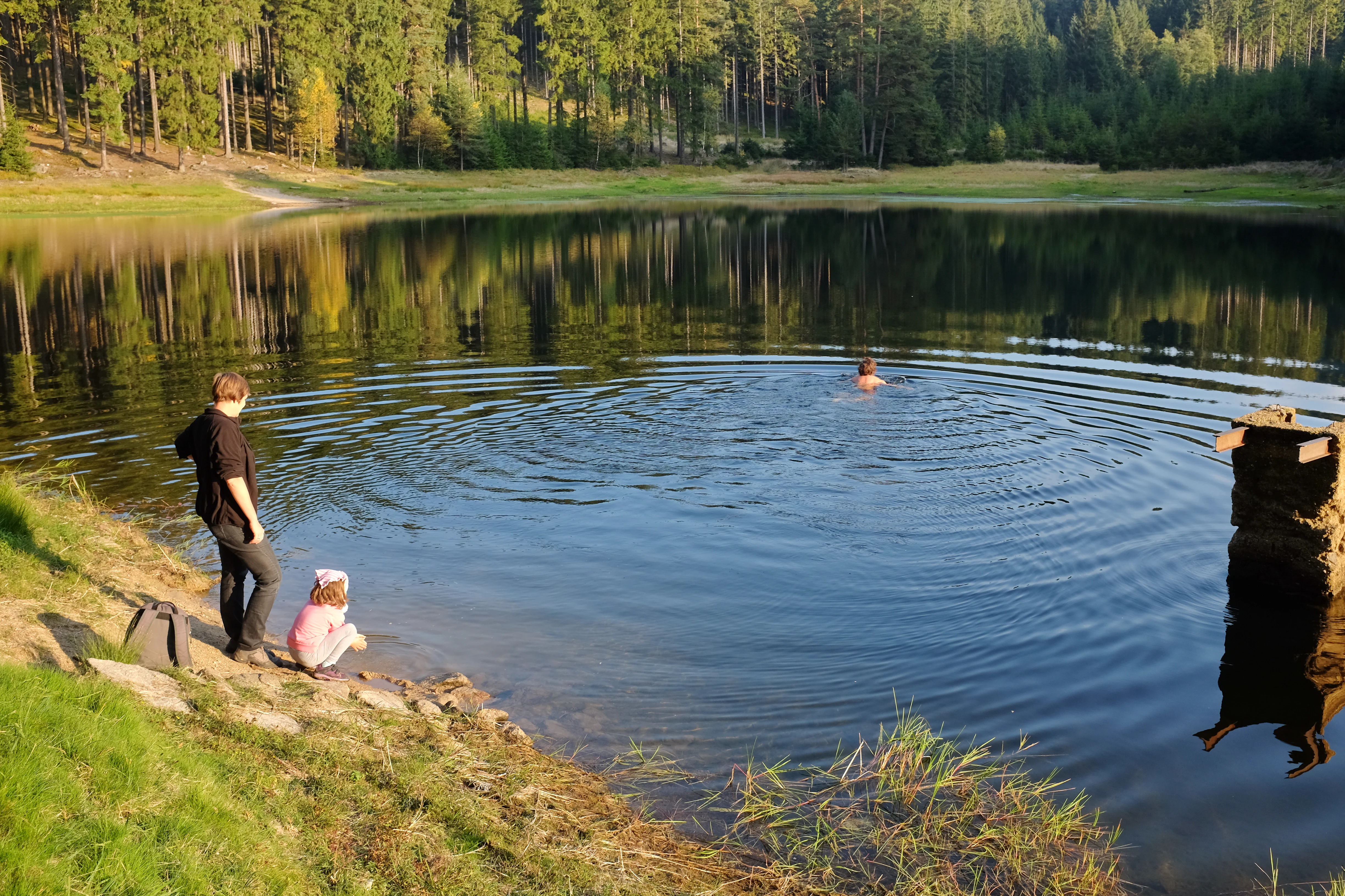
A calm pond surrounded by a dense forest, with people standing at the grassy shoreline and one person swimming in the water.
A pond within the Na Vážkách Natural Monument in the Slavkov Forest.

Na Vážkách history and protected-area timeline

The pond at Na Vážkách has its origins in the early modern mining era of the Slavkov Forest. As part of the Komáří rybníky system, it once supplied water to the Puškařovská stoka, a channel constructed in the 16th century to deliver water from local ponds into the ore processing works of Horní Slavkov. Over time, the industrial use faded and both ponds became primarily recreational and landscape features within the surrounding spruce forest.

The conservation history of the site is more recent. In 2010, intensive research on the white-faced darter and other dragonfly species confirmed the exceptional value of the lower Komáří pond, revealing both a species-rich community and one of the largest known populations of the white-faced darter in Central Europe. On 11 September 2017, the pond and its immediate surroundings were formally declared a přírodní památka, a small natural monument, nested within the larger Slavkov Forest Protected Landscape Area. The protected status did not change public recreational access, and bathing remains allowed, with the reserve managed by the CHKO administration.

Na Vážkách landscape and geographic character

The Na Vážkách reserve sits in a gently undulating section of the Slavkov Forest, surrounded by coniferous woodland dominated by spruce. The bedrock belongs to the Karlovy Vary granite pluton, and the sandy substrate of the pond reflects that geology, producing unusually clear water. The protected pond has gentle bank slopes and receives more sunlight than the upper Komáří pond, which, together with its sandy floor and low nutrient load, defines its special character.

The shoreline is bordered by a narrow zone of emergent vegetation and sedges, while the southern bay opens into a soft, peat-forming transition that connects the open water to the surrounding forest soils. The broader landscape is shaped by the history of mining and water management in the Slavkov Forest, with historic channels and ponds scattered through the forest mosaic.

Na Vážkách ecosystems, habitats, and plant life

The ecological identity of Na Vážkách revolves around its oligotrophic pond and its direct transition into peatland and coniferous forest. Despite its small size, the reserve holds a layered habitat structure: open clear water, sandy bottom with high transparency, littoral vegetation dominated by sedges, a peat-forming southern bay, and spruce forest surrounding the shoreline.

The undisturbed character of the pond is fundamental to its ecological value. Because the water remains nutrient-poor and unpolluted, it can support sensitive dragonfly species whose larvae require high water quality and stable aquatic vegetation. The combination of open water, transitional peatland, and shaded forest edge also makes the site attractive to amphibians and other wetland fauna, and explains why such a tiny locality can host an exceptionally rich community of dragonflies.

Na Vážkách wildlife and species highlights

The wildlife profile of Na Vážkách is overwhelmingly defined by its dragonfly fauna. Twenty-six dragonfly species have been recorded on the site, equivalent to roughly a third of all species known from the Czech Republic. The reserve's priority species is the white-faced darter (Leucorrhinia albifrons), a rare dragonfly protected under Czech law, whose population here is estimated at many thousands of individuals and is considered one of the largest in Central Europe.

The site is also home to other specially protected animals, including the common toad (Bufo bufo), the smooth newt (Lissotriton vulgaris), and the alpine newt (Ichtyosaura alpestris). The combination of these amphibians with the rich dragonfly assemblage underscores how the small pond functions as both a breeding habitat and a stabilizing refuge for sensitive aquatic and semi-aquatic species within the wider Slavkov Forest landscape.

Na Vážkách conservation status and protection priorities

Na Vážkách was declared a protected natural monument in 2017 primarily to safeguard the dragonfly fauna of the lower Komáří pond, and especially the white-faced darter, which depends on the extremely clean, nutrient-poor character of the water. Within the broader Slavkov Forest Protected Landscape Area, the site represents a small but disproportionately important refuge where the historical absence of intensive fish farming has preserved water quality suitable for sensitive species.

The site's conservation significance is amplified by the population size and stability documented during research in 2010, which showed tens of thousands of individual white-faced darters, making this one of the strongest populations in Central Europe. Management authority rests with the CHKO administration, which oversees the reserve while maintaining public recreational access, including continued permission for bathing in the pond.

Na Vážkách cultural meaning and human context

The cultural character of the Na Vážkách area is closely tied to the medieval and early modern mining history of the Slavkov Forest. The pond system once fed the Puškařovská stoka, an engineered channel that supplied water to mining and ore-processing operations in Horní Slavkov, reflecting how local water bodies were reshaped to support the region's silver and tin industries. Today, the forest surrounding the reserve preserves a quieter cultural identity shaped by small settlements, vanished hamlets such as the nearby settlement of Třídomí, and a long tradition of forest use and recreation that continues alongside the site's modern protection status.

Top sights and standout views in Na Vážkách

Na Vážkách stands out as a small protected site punch well above its weight in biodiversity value. The reserve's headline features are the twenty-six recorded dragonfly species, a population of the rare white-faced darter estimated in the tens of thousands, and the unusually clear, sandy-bottomed oligotrophic pond that sustains them. Surrounding spruce forest, a sedge-rich littoral zone, and a peat-forming southern bay give the site a layered ecological structure within just a few hectares, while its 2017 designation within the Slavkov Forest Protected Landscape Area confirms both its national importance and its place within a wider network of Bohemian forest conservation.

Best time to visit Na Vážkách

Late spring and summer are the most rewarding seasons for visiting Na Vážkách, when warm weather brings the dragonfly community to its peak activity and the pond's aquatic and wetland vegetation reach full development. Early summer in particular is the best window for observing adult white-faced darters and other dragonflies on the wing. Autumn visits can still offer pleasant forest scenery and quieter conditions, while winter typically brings frozen pond surfaces and reduced wildlife visibility, though the surrounding spruce forest retains atmospheric charm year-round.


Monthly climate preview

Long-term temperature ranges and monthly precipitation records across representative park coordinates

Na Vážkách Climate Normals and Measured Annual Weather Patterns

Historical data compiled from NASA records reveals measured shifts in monthly temperature averages and precipitation totals for Na Vážkách. Detailed climate profiles break down these long-term meteorological patterns across all twelve months of the year.
Annual mean7 °C
-3 °C18 °C
Jan-3°
Feb-2°
Mar
Apr
May12°
Jun16°
Jul18°
Aug18°
Sep13°
Oct
Nov
Dec-2°
Warmest month
July

17.8 °C

Coolest month
January

-3.1 °C

Wettest month
July

2.7 mm/day

Driest month
April

1.4 mm/day

Park location guide

Geography guide, regional context, and park location map for Na Vážkách

Na Vážkách park geography, regions, and map view in Czechia

Understand where Na Vážkách sits in Czechia through a broader geographic reading of the surrounding landscape, nearby location context, and its mapped position within the national park landscape.

How Na Vážkách fits into Czechia

Czech Republic is a landlocked Central European country with a population of approximately 10.9 million people. The nation was established as an independent state on January 1, 1993, following the dissolution of Czechoslovakia. Its capital and largest city is Prague, with other major urban centers including Brno, Ostrava, Plzeň, and Liberec.

Wider geography shaping Na Vážkách in Czechia

The Czech Republic is a landlocked country in Central Europe. It is bordered by Germany to the west, Austria to the south, Poland to the northeast, and Slovakia to the southeast. The landscape is predominantly hilly, with the territory covering 78,871 square kilometers.

Map view of Na Vážkách

Use this park location map to pinpoint Na Vážkách in Czechia, understand its exact geographic position, and read its mapped placement within the surrounding landscape more clearly.

Pigeon | © OpenStreetMap contributors

Location context for Na Vážkách

Karlovarský kraj

Explore protected area views, clear oligotrophic waters, and surrounding forest terrain.

Na Vážkách Photos and Landscape Scenery: Visualizing Western Bohemia Habitats

Visual documentation captures the unique aquatic habitats, sandy pond shorelines, and spruce forest mosaic defining Na Vážkách. Photographic reference allows researchers and visitors to examine the delicate ecological balance of this protected natural monument more closely.

A calm pond surrounded by a dense forest, with people standing at the grassy shoreline and one person swimming in the water.

Park atlas

Compare regional wetland habitats and connected forest reserves

Explore Protected Areas and Parks Near Na Vážkách in Western Bohemia

Browse nearby national parks and protected landscapes to continue exploring the ecological context surrounding Na Vážkách. Examining adjacent wetland reserves and forest habitats offers a broader view of regional conservation geography.
Natural monumentKarlovy Vary District
About 11 km away#1 closest

Southeast

Velikonoční rybník Natural Monument: Protected Wetland and Amphibian Habitat Geography

A core conservation site within the Slavkov Forest landscape

Velikonoční rybník stands as a noteworthy natural monument in the Karlovy Vary District, protecting essential wetland ecosystems. This small yet vital reservoir provides a specialized habitat for endangered amphibians and dragonflies, serving as a landmark of regional conservation efforts and ecological mapping within the Slavkov Forest region.

Area
0.018 km²
Established
2014
IUCN
IV
Relief
Upland
A soft, impressionistic watercolor painting depicting a wide, marshy landscape with green fields, low hills in the distance, and a small meandering stream.
Nature reserveKarlovarský kraj
About 14 km away#2 closest

South

Prameniště Teplé Nature Reserve: Protected Wetland and River Source Geography

A diverse springhead sanctuary in Karlovarský kraj

Prameniště Teplé stands as a significant nature reserve protecting the essential wetland mosaic surrounding the source of the Teplá River. Featuring a delicate balance of bogs, meadows, and forest fringes, this protected area preserves the ecological character of western Bohemian water-dominated landscapes through its unique spring-fed geography.

Area
0.429 km²
Established
1993
IUCN
IV
Relief
Upland
Natural monumentKarlovarský kraj
About 15 km away#3 closest

East

Viklan Natural Monument: A Geological Landmark in the Karlovarský kraj Landscape

Exploring the historic balancing granite boulder and surrounding pastoral terrain

Viklan functions as a compact yet iconic natural monument, shielding a prominent 3.5 meter granite boulder from modern disturbance. Set amidst the rolling, short-grass pastures of the Karlovarský kraj, the site serves as a vital point for geological mapping and historical study, documenting both natural weathering processes and long-standing regional folklore tied to this unusual stone formation.

Established
1979
IUCN
III
Relief
Upland
Access
Easy access
Natural monumentKarlovarský kraj
About 19 km away#4 closest

South

Milhostovské mofety: Geological Atlas of Natural Monuments in Karlovarský kraj

Cold mofette gas vents and wetland floodplain habitat.

Milhostovské mofety is a specialized natural monument protecting a cluster of carbon dioxide mofettes in the Cheb District. This site offers insight into regional post-volcanic phenomena, featuring shallow craters, alder carr landscapes, and amphibolite bedrock structures that illustrate the unique geological character of the Slavkov Forest territory.

Area
0.002 km²
Established
1993
IUCN
III
Relief
Lowland
Watercolor painting of columnar basalt formations surrounded by a pine forest and soft, layered hills in the background.
Natural monumentKarlovarský kraj
About 24 km away#5 closest

Northwest

Rotava Natural Monument: Geological Landforms and Basalt Outcrops in the Karlovarský kraj Region

Protected volcanic terrain and rare botanical habitats in the Czech Republic

Rotava Natural Monument showcases remarkable vertical basalt columns formed by ancient volcanic activity. Located in the Karlovarský kraj region, this site provides a dense, concentrated look at columnar jointing and the specific meadow flora that thrives in its mineral-rich, acidic soil conditions, serving as a landmark for regional geological study.

Area
0.003 km²
Established
1978
IUCN
IV
Relief
Mountain
A horizontal watercolor illustration depicting a soft, green, mountain landscape with hills, conifers, and a waterlogged meadow.
Natural monumentKarlovy Vary Region
About 27 km away#6 closest

North

Rudenská luční prameniště Natural Monument: Protected Mountain Wetland Atlas

Karlovy Vary Region Ore Mountains landscape mapping

Rudenská luční prameniště is a protected mountain wetland in the Ore Mountains, defined by a distinct mosaic of spring fens, peat deposits, and mountain meadows. Its geographic layout, spanning twenty three hectares across sloping terrain, creates a vital drainage system for the local landscape. By examining this protected site, you can better understand the unique hydrological and botanical features that distinguish these rare mountain mire complexes from the surrounding highland forests.

Area
0.232 km²
Established
2020
IUCN
IV
Relief
Mountain
Natural monumentKarlovarský kraj
About 31 km away#7 closest

North

Vlčí jámy Natural Monument: Protected Geological and Industrial Heritage in Bohemia

Ore Mountains mining collapse and relict microclimate landscape

Vlčí jámy protects a rare intersection of medieval mining history and environmental significance in the Karlovarský kraj. The site is defined by two deep collapse features, Ledová jáma and Vlčí jáma, which function as persistent cold traps. These geological anomalies support critically endangered mosses and bat colonies, illustrating how abandoned industrial landscapes in the Ore Mountains evolve into essential, small-scale protected habitats.

Area
0.014 km²
Established
1975
IUCN
III
Relief
Mountain
Natural monumentKarlovarský kraj
About 33 km away#8 closest

Northeast

Malý Stolec Natural Monument: Volcanic Landscape and Regional Protected Area Atlas

Exposing neovolcanic rock and ancient feeder conduits in Karlovarský kraj

Malý Stolec provides a focused view into the volcanic processes of the Doupovské hory. This natural monument displays rare geologic features including columnar jointing, coarse agglomeratic tuffs, and an intruded lava body. Its location on the southern slopes above the Ohře river offers a distinct landscape character that demonstrates how localized protected areas contribute to broader European conservation frameworks.

Area
0.06 km²
Established
2016
IUCN
IV
Relief
Mountain

Common questions about visiting, size, designation, and location context for Na Vážkách

Na Vážkách FAQs for park facts, access, geography, and protected area context

Find quick answers about Na Vážkách, including protected-area facts, park geography, trail and visitor context, and how the park fits into its surrounding country and regional landscape.
MoriAtlas Explorer

Continue Your Protected Areas Search Across the Global Atlas

Deepen your exploration by continuing the structured search for national parks and protected areas worldwide. Utilize the comprehensive filtering capabilities to compare different conservation landscapes and refine your understanding of global park geography. Discover more about the distribution and characteristics of protected natural areas.

Global natural geography